 W
WBrunswick Peninsula is a large peninsula in Magallanes y la Antártica Region, Patagonia, Chile, at 53.5°S 71.4166667°W. It is 16 kilometres (9.9 mi) wide at its base in the north, and almost 80 kilometres (50 mi) in the south. The Strait of Magellan defines the eastern and southern limits while the Otway Sound delimits its western shores. It measures 115 kilometres (71 mi) in length from the base to Cape Froward, the southernmost point of the American mainland. This yields an area of more than 6,300 square kilometres (2,400 sq mi).
 W
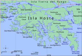
WPeninsula Hardy is a peninsula at one of the most southerly extremes of South America. It is the southern landform which extends into the Drake Passage to make the Bahia Nassau. It is part of a large island called Hoste, next to Isla Navarino and Isla Grande de Tierra del Fuego. It is located in the Commune of Cabo de Hornos, belonging to the Antártica Chilena Province of the Magallanes y Antártica Chilena Region, Chile. False Cape Horn is located at the southern tip of this peninsula.
 W
WThe Lacuy Peninsula, alternatively spelled with i, is located in the northwestern corner of Chiloé Island. The peninsula lies a few kilometer west of Ancud but the isthmus that connects to the rest Chiloé Island lies more than 10 km west of Ancud. During colonial times the peninsula hosted a Spanish fort system. consisting of three batteries, one sentinel outpost and one fort. The fort, named Fuerte de Agüi, was the site of the battle of Agüi in 1820. The geological Lacui Formation is named after the peninsula.
 W
WMejillones Peninsula protrudes from the coast of northern Chile north of Antofagasta and south of the port of Mejillones.
WMuñoz Gamero Peninsula is a peninsula in Chile. It is bordered on the west by the Smyth Channel and is connected to the Patagonia mainland by a narrow isthmus, between Skyring Sound to the south and the Obstrucción estuary to the north. The peninsula consists of several smaller peninsulas jutting from its central land mass. Riesco Island was considered part of this peninsula until 1904. The lake that occupies a significant part of its central portion was discovered in 1945. The peninsula is home to Monte Burney and Gran Campo Nevado.
 W
WThe Taitao Peninsula is a westward projection of the mainland of Chile, with which it is connected by the narrow Isthmus of Ofqui, over which the natives and early missionaries were accustomed to carry their boats between the Moraleda Channel and Gulf of Penas. It is situated in the Aysén del General Carlos Ibáñez del Campo Region and a part of this peninsula is located inside the boundaries of Laguna San Rafael National Park. The Presidente Ríos Lake, with a surface area of 352 square kilometres (136 sq mi), lies in the middle of the peninsula. A southward incurving projection of the outer shoreline of this peninsula is known as Tres Montes peninsula, the most southern point of which is a cape of the same name.
 W
WThe Tres Montes Peninsula is a southwestward projection of Taitao Peninsula which in turn connects to the mainland of Chile by the narrow Isthmus of Ofqui. The peninsula is situated in Aysén del General Carlos Ibáñez del Campo Region close to the Chile Triple Junction of the Nazca, Antarctic and South American plates.
 W
WTumbes Peninsula is a peninsula in Bío Bío Region, Chile. It connects to the mainland through the Plains of Talcahuano where the city of Talcahuano is located. The peninsula points northward, making the city of Talcahuano an excellent port and allowing port facilities and harbours to be located in its east side. Most of the peninsula is covered by monocultures of exotic trees which are harvested by clearcutting.