 W
WThe Basaltic Prisms of Santa María Regla are tall columnar joints of basalt rock near Huasca de Ocampo in the Mexican state of Hidalgo, that line a ravine through which water runs from the San Antonio Dam. This ravine area was part of the Santa María Regla Hacienda and was first promoted by Alexander von Humboldt in 1803.
 W
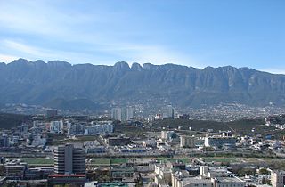
WThe Cerro de Chipinque is a mountain in the San Pedro Garza García, Monterrey and Santa Catarina municipalities; state of Nuevo León, Mexico. The mountain is part of the Sierra Madre Oriental range and the Cumbres de Monterrey National Park. The summit reaches 2,229 meters above sea level. The mountain is a symbol for the Monterrey metropolitan area. The mountain is surrounded by Santa Catarina valley, San Pedro valley, mount El Mirador, la Silla river, Ballesteros Canyon and La Huasteca canyon. The “Parque ecológico Chipinque” is on the north slope of the mountain.
 W
WCerro de la Loma Larga, or Loma Larga, is a lower extension of the Sierra Madre Oriental, particularly of Cerro de las Mitras. located in the Monterrey, Nuevo León metropolitan area.
 W
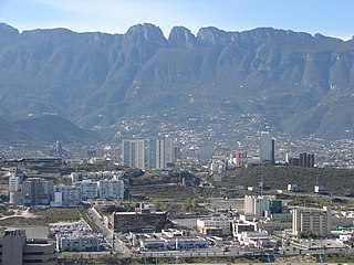
WThe Cerro de la Silla is a mountain and natural monument located within the metropolitan area of the city of Monterrey, Nuevo León, in northeastern Mexico. Named for its distinctive saddle-shaped profile when viewed from the west, it is a well-known symbol of the city of Monterrey, despite being located in the adjacent municipality of Guadalupe.
 W
WThe arch of Cabo San Lucas, is a distinctive rock formation at the southern tip of Cabo San Lucas, which is itself the extreme southern end of Mexico's Baja California Peninsula. The arch is locally known as "El Arco," which means "the arch" in Spanish, or "Land's End."
 W
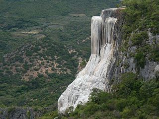
WHierve el Agua is a set of natural rock formations in the Mexican state of Oaxaca that resemble cascades of water. The site is located about 70 km east of Oaxaca city, past Mitla, in the municipality of San Lorenzo Albarradas, with a narrow, winding unpaved road leading to the site. The site consists of two rock shelves or cliffs which rise between fifty and ninety metres from the valley below, from which extend nearly white rock formations which look like waterfalls. These formations are created by fresh water springs, whose water is over-saturated with calcium carbonate and other minerals. As the water trickles over the cliffs, the excess minerals are deposited, much in the same manner that stalactites are formed in caves. One of the cliffs, called the "cascada chica" or the Amphitheatre, contains two large artificial pools for swimming as well as a number of small natural pools. One of the artificial pools is very near the edge of the cliff.
 W
WPeña de Bernal is a 433 m (1,421 ft) tall monolith, one of the tallest in the world. Peña de Bernal is located in San Sebastián Bernal, a small town in the Mexican state of Querétaro. It is one of the most touristic sites near the capital of Querétaro and considered one of the 13 Wonders of Mexico.
 W
WEl Potrero Chico is an internationally renowned rock climbing area in the Mexican state of Nuevo León, 3 kilometres (1.9 mi) outside the town of Hidalgo, within Sierra del Fraile protected area. El Potrero Chico is a unique geological formation of limestone cliffs and spires, some as high as 2,000 feet (610 m).