 W
WThis is a list of active and extinct volcanoes in Turkey.
 W
WGöllü is a lava dome located in central Turkey. The volcano has produced rhyolite, dacite and basalt. The lavas have been dated at 1.33 to 0.84 million years by fission track dating of obsidian. The dome lies above the Tertiary Derinkuyu caldera.
 W
WKaraca Dağ is a shield volcano located in eastern Turkey.
 W
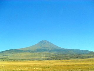
WKaradağ is an extinct volcano in Karaman Province, Turkey.
 W
WKarapınar Field is a volcanic field in central Anatolia, Asian Turkey.
 W
WKula is a volcanic field located in western Turkey. Kula field consists of a broad area of cinder cones and maars. It is the westernmost volcano of Turkey. The volcanic character of the area was recognized in antiquity, when it was named Katakekaumene from the appearance of the environment, which was mostly suited for viticulture. Volcanism began in the Miocene and over three stages continued in the Holocene. It is associated with the presence of two neighbouring active graben structures. Most cones are of small size and one of them has its internal structure exposed. Total volume of the volcanic field extrusion is about 2,3 km3 and the lavas are rich in xenoliths. The plant succession on the lava fields and cones was subject of a study in 1974, which found that the vegetation is influenced both by climate factors such as temperature and precipitation and the orientation of the sides of the volcanoes in question. Footprints of prehistoric humans have been found in the area. The area is a geopark recognized by UNESCO given the universal and scientific value.
 W
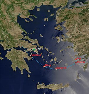
WThe South Aegean Volcanic Arc is a volcanic arc in the South Aegean Sea formed by plate tectonics as a consequence of the subduction of the African plate tectonic plate beneath the Eurasian plate. The southern Aegean is one of the most rapidly deforming regions of the Himalayan-Alpine mountain belt. It is approximately 450 km long and 20 km to 40 km wide and runs from the Isthmus of Corinth on the Greek mainland to the Bodrum peninsula on the Turkish mainland.
 W
WTendürek is a shield volcano located in the Ağrı and Van provinces of eastern Turkey, close to the borders with Iran. The elongated volcano rises 1,800 m (5,906 ft) above the Doğubeyazıt plain, south of Mount Ararat. Two main cones with a crater each and several minor lateral cones form the edifice. The edifice dates 700,000–500,000 years BP to 13,000 BP and is mostly constructed from basaltic lavas, with some pyroclastics and trachytic/trachyandesitic lavas. It has a volume of more than 300 km3 and covers a surface area of about 650 km2. Pyroclastic cones with basaltic lava flows on the eastern side of the mountain are around 2,500 years old. The last known eruption may have been a gas and ash eruption in 1855, and hydrothermal systems exist on the volcano. Since 1993, the volcano has been subsiding in a ring fault. The Armenian name for the mountain was Tondrak. The medieval Armenian Tondrakians, a religious movement of the 950s, is named after this area.