 W
WAngria Bank is a bank, a shallow sunken atoll, on the continental shelf off the west coast of India. It is located 105 kilometres (65 mi) west of Vijaydurg, Maharashtra.
 W
WBalaghat range is a mountain range of low elevation in the Maharashtra state of India. Balaghat Range runs south-eastwards from Western Ghats at the Harishchandra Range to the border of Maharashtra and Karnataka states.It extends about 320 kilometers. The range traverses the districts of Ahmednagar, Beed, Latur, Osmanabad and Solapur in Maharashtra.
 W
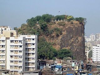
WGilbert Hill is a 200 ft (61 m) monolith column of black basalt rock at Andheri, in Mumbai, India. The rock has a sheer vertical face and was formed when molten lava was squeezed out of the Earth's clefts during the Mesozoic Era about 66 million years ago. During that era, molten lava had spread around most of the Indian states of Maharashtra, Gujarat and Madhya Pradesh, covering an area of 50,000 square kilometres (19,000 sq mi). The volcanic eruptions were also responsible for the destruction of plant and animal life during that era.
 W
WThe Harischandra Range is a spur of the Western Ghats in Maharashtra, India. It runs in a northwest to southeast direction stretching from northeast of Pune district through Ahmednagar and Beed to Osmanabad district. It lies between the Godavari and the Bhima rivers and acts as a water divide between the Godavari and Krishna river basins. These are low-lying hills with an average elevation of only 600 metres (1,970 ft) and they gain in elevation towards the northwest. Geologically, these hills are similar to the Deccan Plateau and are composed of basaltic lava deposits. The range derives its name from the Harischandragarh peak, a popular trekking spot and the highest peak of the range. The hills are covered under deciduous forests especially teak but much of it has been degraded due to the rapid industrialisation and urbanisation in this region. The city of Ahmednagar is the largest in this region.
 W
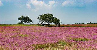
WThe Kas Plateau Reserved Forest, also known as the Kaas Pathar, is a plateau situated 25 kilometres west from Satara city in Maharashtra, India. It falls under the Sahyadri Sub Cluster of the Western Ghats, and it became a part of a UNESCO World Natural Heritage Site in 2012.
 W
WMahim Bay is a bay, part of the Arabian Sea in Mumbai, India. The southern end is Worli, northern end is Bandra Reclamation and Mahim is in the centre. The bay was named after the islands of Mahim and Salsette were merged in the early 19th century. The Mithi River drains into Mahim Creek which drains into the Bay, and forms the border between the city and its suburbs.
 W
WMangi-Tungi is a prominent twin-pinnacled peak with plateau in between, located near Tahrabad about 125 km from Nashik, Maharashtra, India. Mangi, 4,343 ft (1,324 m) high above sea level, is the western pinnacle and Tungi, 4,366 ft (1,331 m) high, the eastern. Mangi-Tungi is only 100 km away from Dhule, a well known city and district place in North Maharashtra (Khandesh).
 W
WThe Shree Vajreshwari Yogini Devi Mandir is a Hindu temple dedicated to the goddess Vajreshwari, located in the town Vajreshwari, 75 km away from Mumbai. The town, earlier known as Vadvali, was renamed Vajreshwari in honour of the presiding deity of the temple.
 W
WThe Western Ghats, also the "Sahyadri", is a mountain range that covers an area of 140,000 square kilometres (54,000 sq mi) in a stretch of 1,600 kilometres (990 mi) parallel to the western coast of the Indian peninsula, traversing the states of Tamil Nadu, Kerala, Karnataka, Goa, Maharashtra and Gujarat. It is a UNESCO World Heritage Site and is one of the eight hot-spots of biological diversity in the world. It is sometimes called the Great Escarpment of India. It contains a very large proportion of the country's flora and fauna, many of which are only found in India and nowhere else in the world. According to UNESCO, the Western Ghats are older than the Himalayas. They influence Indian monsoon weather patterns by intercepting the rain-laden monsoon winds that sweep in from the south-west during late summer. The range runs north to south along the western edge of the Deccan Plateau, and separates the plateau from a narrow coastal plain, called Konkan, along the Arabian Sea. A total of thirty-nine areas in the Western Ghats, including national parks, wildlife sanctuaries and reserve forests, were designated as world heritage sites in 2012 – twenty in Kerala, ten in Karnataka, six in Tamil Nadu and four in Maharashtra.