 W
WBangan Hill National Park is a protected area of the Philippines located in the municipality of Bayombong, Nueva Vizcaya in Cagayan Valley. The park covers an area of 13.90 hectares. It was declared a national park in 1995 by virtue of Republic Act No. 7954.
 W
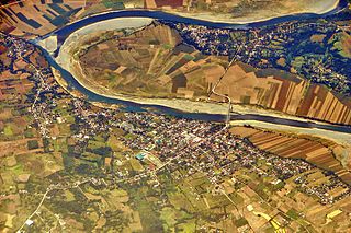
WThe Cagayan River, also known as the Rio Grande de Cagayan, is the longest river and the largest river by discharge volume of water in the Philippines. It has a total length of approximately 505 kilometres (314 mi) and a drainage basin covering 27,753 square kilometres (10,715 sq mi). It is located in the Cagayan Valley region in northeastern part of Luzon Island and traverses the provinces of Nueva Vizcaya, Quirino, Isabela and Cagayan.
 W
WThe Caraballo Mountains is a mountain range in the central part of Luzon island in the Philippines, situated between Cordillera Central and Sierra Madre mountain ranges. The mountains serve as the location of the headwaters of the Cagayan River, the longest in the country.
 W
WDalton Pass, also called Balete Pass, is a zigzag road and mountain pass that joins the provinces of Nueva Ecija and Nueva Vizcaya, in central Luzon island of the Philippines. It is part of Cagayan Valley Road segment of Pan-Philippine Highway.
 W
WMount Guiwan is a mountain in the Sierra Madre range in Alfonso Castañeda, Nueva Vizcaya, Philippines. It is probably the highest peak of Sierra Madre mountain range with a height of 1,915 metres (6,283 ft) above sea level according to NAMRIA topographic map. Bugkalots have long established trails which they use when hunting.
 W
WMagat River is a river in the Philippine island of Luzon with a total length of 183 kilometres (114 mi). It originates in the Nueva Vizcaya municipality of Aritao, where the Santa Fe River joins the Marang. It is the largest tributary of the Cagayan River by discharge volume of water, with an estimated drainage area of 5,110 square kilometres (1,970 sq mi), roughly twenty percent of the total drainage area of the Cagayan River.
 W
WMount Bintuod is a mountain in the Sierra Madre range in the municipality of Alfonso Castañeda in Nueva Vizcaya province. It is probably the highest peak in the Philippines longest mountain range with a first GPS-based measurement of 1,915 metres (6,283 ft) above sea level, from an expedition in April 2012. There are no records of the first ascent, but local tribe people have long established paths.
 W
WMount Pulag is Luzon’s highest peak at 2,928 metres (9,606 ft) above sea level. It is also a dormant volcano. The borders between the provinces of Benguet, Ifugao, and Nueva Vizcaya meet at the mountain's peak.
 W
WThe Salinas Natural Monument is a natural monument comprising saline springs and forested mountains in southern Cagayan Valley in the Philippines. It is one of four protected areas in the landlocked province of Nueva Vizcaya spanning an area of 6,675.56 hectares in the municipalities of Bambang, Kayapa and Aritao. The park was established on 18 May 1914 as the Salinas Forest Reserve covering the Salinas Salt Springs and surrounding forest through Executive Order No. 44 signed by Governor-General Francis Burton Harrison. In 1926, through amendments made in Proclamation No. 53 by Governor-General Leonard Wood, the forest reserve was re-established as the Salinas Deer Refuge. Salinas was finally declared a natural monument in 2000 under the National Integrated Protected Areas System through Proclamation No. 275 by President Joseph Estrada.