 W
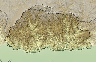
WThe mountains of Bhutan are some of the most prominent natural geographic features of the kingdom. Located on the southern end of the Eastern Himalaya, Bhutan has one of the most rugged mountain terrains in the world, whose elevations range from 160 metres (520 ft) to more than 7,000 metres (23,000 ft) above sea level, in some cases within distances of less than 100 kilometres (62 mi) of each other. Bhutan's highest peak, at 7,570 metres (24,840 ft) above sea level, is north-central Gangkhar Puensum, close to the border with China; the third highest peak, Jomolhari, overlooking the Chumbi Valley in the west, is 7,314 metres (23,996 ft) above sea level; nineteen other peaks exceed 7,000 metres (23,000 ft). Weather is extreme in the mountains: the high peaks have perpetual snow, and the lesser mountains and hewn gorges have high winds all year round, making them barren brown wind tunnels in summer, and frozen wastelands in winter. The blizzards generated in the north each winter often drift southward into the central highlands.
WChomolhari Kang is a 7046m mountain in the Himalayas in Gasa District, Bhutan near the border with Tibet, China. Quotes on its height vary from 7034m to 7121m, but 7046m is the most common figure. A Chinese crew who first climbed the mountain in 2013 reported a GPS height of 7,054m.
 W
WGangkhar Puensum is the highest mountain in Bhutan and the highest unclimbed mountain in the world, with an elevation of 7,570 metres (24,836 ft) and a prominence of 2,995 metres (9,826 ft). Its name means "White Peak of the Three Spiritual Brothers".
WJichu Drake is a mountain in the Himalayas, and a companion peak to Mount Jomolhari. Its height is given variously as 6714m, 6789m, 6797m, 6970m or 6989m by various sources. Jitchu Drake has a double summit, with the lower summit to the south.
 W
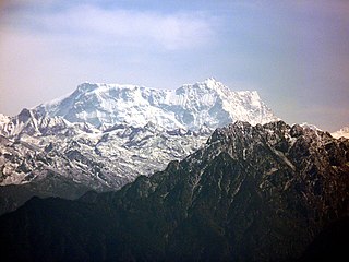
WJomolhari or Chomolhari sometimes known as "the bride of Kangchenjunga”, is a mountain in the Himalayas, straddling the border between Yadong County of Tibet, China and the Paro district of Bhutan. The north face rises over 2,700 metres (8,900 ft) above the barren plains. The mountain is the source of the Paro Chu which flows from the south side and the Amo Chu which flows from the north side.
WKangphu Kang or Shimokangri is a mountain in the Himalayas. At 7,204 m (23,635 ft) above sea level it is the 107th highest mountain in the world. The peak is located on the border of Bhutan and China (Tibet).
 W
WKula Kangri is claimed by many authorities to be the highest mountain in Bhutan but this is disputed by others, who claim that Kula Kangri is wholly in Tibet. The first ascent was by a combined Japanese and Chinese team in 1986. The mountain occupies two ranges, the Himalaya and the Bhutan Himalaya.
 W
WLiangkang Kangri is a mountain peak in the Himalayas on the border between Bhutan and China, as well as at the southeastern end of territory claimed by both countries. Liangkang Kangri is 7,535 metres (24,721 ft) high. To the south, a ridge leads to the 7,570-metre (24,840 ft) Gangkhar Puensum 2 kilometres (1.2 mi) to the south-southeast. Due to the low saddle height of 234 metres (768 ft), Liangkang Kangri is not regarded as an independent mountain. Westward a ridge leads to the 6,680-metre (21,920 ft) high Chumhari Kang. The Liangkanggletscher on the northwest flank and the Namsanggletscher on the eastern flank of Liangkang Kangri form the headwaters of the Lhobrak Chhu, a source river of Kuri Chhu. The glacier on the southwest flank belongs to the catchment area of Angde Chhu.
WTongshanjiabu is a mountain in the Himalayas. At 7,207 metres (23,645 ft) tall, Tongshanjiabu is the 103rd tallest mountain in the world. It sits in the disputed border territory between Bhutan and China. Tongshanjiabu has never been officially climbed.