 W
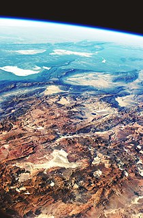
WThe Altiplano–Puna volcanic complex, also known as APVC, is a complex of volcanic systems in the Puna of the Andes. It is located in the Altiplano area, a highland bounded by the Bolivian Cordillera Real in the east and by the main chain of the Andes, the Western Cordillera, in the west. It results from the subduction of the Nazca Plate beneath the South American Plate. Melts caused by subduction have generated the volcanoes of the Andean Volcanic Belt including the APVC. The volcanic province is located between 21° S–24° S latitude. The APVC spans the countries of Argentina, Bolivia and Chile.
 W
WThe Andagua volcanic field is a volcanic field in southern Peru which includes a number of cinder cones, lava domes and lava flows which have filled the Andagua Valley. The volcanic field is part of a larger volcanic province that clusters around the Colca River and is mostly of Pleistocene age, although the Andagua sector also features volcanic cones with historical activity, with the last eruption about 370 years ago. Eruptions were mostly effusive, generating lava flows, cones and small eruption columns. Future eruptions are possible, and there is ongoing fumarolic activity. Volcanic activity in the field has flooded the Andahua valley with lava flows, damming local watersheds in the Laguna de Chachas, Laguna Mamacocha and Laguna Pumajallo lakes and burying the course of the Andagua River. The Andahua valley segment of the larger volcanic province was declared a geopark in 2015.
 W
WThe Eltanin impact is thought to be an asteroid impact in the eastern part of the South Pacific Ocean during the Pliocene-Pleistocene boundary around 2.51 ± 0.07 million years ago. The location was at the edge of the Bellingshausen Sea 1,500 km (950 mi) southwest of Chile. The asteroid was estimated to be about one to four km in diameter and the impact would have left a crater approximately 35 km (22 mi) across.
 W
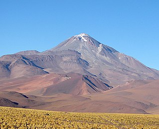
WLlullaillaco is a dormant stratovolcano at the border of Argentina and Chile. It lies in the Puna de Atacama, a region of tall volcanic peaks on a high plateau close to the Atacama Desert, one of the driest places in the world. It is the second highest active volcano in the world after Ojos del Salado.
 W
WThe Last Glacial Period (LGP) occurred from the end of the Eemian to the end of the Younger Dryas, encompassing the period c. 115,000 – c. 11,700 years ago. The LGP is part of a larger sequence of glacial and interglacial periods known as the Quaternary glaciation which started around 2,588,000 years ago and is ongoing. The definition of the Quaternary as beginning 2.58 million years ago is based on the formation of the Arctic ice cap. The Antarctic ice sheet began to form earlier, at about 34 Ma, in the mid-Cenozoic. The term Late Cenozoic Ice Age is used to include this early phase.
 W
WPaleo-Indians, Paleoindians or Paleo-Americans, were the first peoples who entered, and subsequently inhabited, the Americas during the final glacial episodes of the late Pleistocene period. The prefix "paleo-" comes from the Greek adjective palaios (παλαιός), meaning "old" or "ancient". The term "Paleo-Indians" applies specifically to the lithic period in the Western Hemisphere and is distinct from the term "Paleolithic".
 W
WPali-Aike volcanic field is a volcanic field in Argentina which straddles the border with Chile. It is part of a province of back-arc volcanoes in Patagonia, which formed from processes involving the collision of the Chile Rise with the Peru–Chile Trench. It lies farther east than the Austral Volcanic Zone, the volcanic arc which forms the Andean Volcanic Belt at this latitude.
 W
WLake Tauca is a former lake in the Altiplano of Bolivia. It is also known as Lake Pocoyu for its constituent lakes: Lake Poopó, Salar de Coipasa and Salar de Uyuni. The lake covered large parts of the southern Altiplano between the Eastern Cordillera and the Western Cordillera, covering an estimated 48,000 to 80,000 square kilometres of the basins of present-day Lake Poopó and the Salars of Uyuni, Coipasa and adjacent basins. Water levels varied, possibly reaching 3,800 metres (12,500 ft) in altitude. The lake was saline. The lake received water from Lake Titicaca, but whether this contributed most of Tauca's water or only a small amount is controversial; the quantity was sufficient to influence the local climate and depress the underlying terrain with its weight. Diatoms, plants and animals developed in the lake, sometimes forming reef knolls.
 W
WTupungato, one of the highest mountains in the Americas, is a massive Andean lava dome dating to Pleistocene times. It lies on the border between the Chilean Metropolitan Region and the Argentine province of Mendoza, about 100 km (62 mi) south of Aconcagua, the highest peak of both the Southern and Western hemispheres. Immediately to its southwest is the active Tupungatito volcano, which last erupted in 1987.