 W
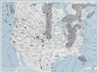
WThe blizzard of 1977 hit Western New York as well as southern Ontario from January 28 to February 1. Daily peak wind gusts ranging from 46 to 69 mph were recorded by the National Weather Service in Buffalo, with snowfall as high as 100 in (254 cm) recorded in areas, and the high winds blew this into drifts of 30 to 40 ft. There were 23 total storm-related deaths in Western New York, with five more in northern New York.
 W
WThe cold wave of January 1977 produced the only known trace of snow in the greater Miami area of Florida ever reported. It occurred following the passage of a strong cold front, in combination with a high-pressure area situated over the Mississippi River Valley. As a result, cold air moved far to the south across Florida, causing both snow flurries and record low temperatures. Most notably, the weather system brought snow flurries as far south as Homestead on January 19. No snow had ever been reported in southeastern Florida before or since. Damage was most significant to agriculture, as major losses occurred to Citrus fruits and tender vegetables. Statewide, agricultural damage from the cold wave totaled to $350 million (1977 USD), and losses overall totaled to $2 billion (1977 USD). One fatality occurred due to an automobile accident in Central Florida, which was related to the cold wave.
 W
WHurricane Anita was a powerful Atlantic hurricane during the otherwise quiet 1977 Atlantic hurricane season, and the latest first named storm on record since tropical cyclones were first named in 1950. The first tropical cyclone of the season, Anita developed from a tropical wave on August 29 in the north-central Gulf of Mexico. It tracked westward into an area with conditions favorable for further development, and quickly intensified into a hurricane by late on August 30. Initially, Anita was forecast to strike Texas, though a building ridge turned it to the west-southwest. The hurricane rapidly strengthened to attain peak winds of 175 mph (280 km/h), and on September 2 Anita made landfall in eastern Tamaulipas as a Category 5 hurricane. It quickly weakened as it crossed Mexico, and after briefly redeveloping into a tropical depression in the eastern Pacific Ocean, Anita dissipated on September 4 to the south of the Baja California Peninsula. Anita was the first major hurricane to form in The Gulf of Mexico since Hurricane Ethel of 1960.
 W
WThe Independence Day Derecho of 1977 was a derecho, or long-lived windstorm associated with a fast-moving band of thunderstorms, that occurred in the northern Great Plains of the U.S. on July 4, 1977. It lasted around 15½ hours. The derecho formed in Minnesota around 10 a.m. CDT on July 4 and became more intense around noon in the central part of the state. The derecho produced winds of 80-100 mph (130–160 km/h) in northern Wisconsin felling thousands of trees in the northern part of the state.
 W
WThe Johnstown flood of 1977, also known as the second great flood of Johnstown and the Johnstown disaster, was a major flood which began on the night of July 19, 1977, when heavy rainfall caused widespread flash flooding in Cambria County, Pennsylvania, United States, including the city of Johnstown and the Conemaugh Valley.
 W
WSouthern Airways Flight 242 was a flight from Muscle Shoals, Alabama to Atlanta, Georgia with a stop in Huntsville, Alabama. On April 4, 1977, it executed a forced landing on Georgia State Route 381 in New Hope, Paulding County, Georgia, United States, after suffering hail damage and losing thrust on both engines in a severe thunderstorm.
 W
WThis page documents the tornadoes and tornado outbreaks of 1977, primarily in the United States. Most tornadoes form in the U.S., although some events may take place internationally. Tornado statistics for older years like this often appear significantly lower than modern years due to fewer reports or confirmed tornadoes.
 W
WTyphoon Babe, also known as the Okinoerabu Typhoon , and also known as Typhoon Miling in the Philippines, was regarded as "the worst typhoon to threaten Japan in 18 years." Developing as a tropical depression on September 2, Babe initially tracked west-northwestward as it intensified. On September 5, an abrupt shift in steering currents caused the system to turn north-northwestward. Early on September 6, the system intensified into a typhoon. Over the following two days, Babe quickly intensified, ultimately attaining its peak intensity early on September 8 with winds of 240 km/h (150 mph) and a barometric pressure of 905 mbar. Not long after reaching this strength, another shift in the steering patterns caused the typhoon to execute a prolonged counter-clockwise arc, causing it to track through the Ryukyu Islands southwest of Japan, as it interacted with a low pressure originating from the Korean Peninsula. During this time, the system gradually weakened and eventually it made landfall near Shanghai, China on September 11 as a minimal typhoon before dissipating inland the following day. Coincidentally, Typhoon Babe and Atlantic Hurricane Babe existed at the same time from September 3–9.