 W
WThe Nez Perce National Historical Park is a United States National Historical Park comprising 38 sites located throughout the states of Idaho, Montana, Oregon, and Washington, which included traditional aboriginal lands of the Nez Perce people. The sites are strongly associated with the resistance of Chief Joseph and his band, who in June 1877 took off from Oregon in an attempt to reach freedom in Canada and avoid being forced on to a reservation. They were pursued by U.S. Army cavalry forces and fought numerous skirmishes against them.
WThe Battle of Bear Paw was the final engagement of the Nez Perce War of 1877. Following a 1,200-mile (1,900 km) running fight from western Idaho over the previous four months, the U.S. Army managed to corner most of the Nez Perce led by Chief Joseph in early October 1877 in northern Montana Territory, just 42 miles (68 km) south of the border with Canada, where the Nez Perce intended to seek refuge from persecution by the U.S. government.
 W
WThe Battle of Canyon Creek was a military engagement between the Nez Perce Indians and the United States 7th Cavalry. The battle was part of the larger Indian Wars of the latter 19th century and the immediate Nez Perce War. It took place on September 13, 1877, west of present-day Billings, Montana in the canyons and benches around Canyon Creek.
 W
WThe Battle of the Clearwater was a battle between the Nez Perce under Chief Joseph and the United States army. The army under General O. O. Howard surprised a Nez Perce village. The Nez Perce counter-attacked and inflicted significant casualties on the soldiers, but they were forced to abandon the village. After the battle, the Nez Perce retreated and crossed the Bitterroot Mountains via Lolo Pass with General Howard in pursuit.
 W
WBig Hole National Battlefield preserves a Nez Perce War battlefield located in Montana, United States. The Nez Perce fought a delaying action against the 7th Infantry Regiment here on August 9 and 10, 1877, during their failed attempt to escape to Canada. This action, the Battle of the Big Hole, was the largest battle fought between the Nez Perce and U.S. Government forces in the five-month conflict known as the Nez Perce War. In 1992 the park was made a part of Nez Perce National Historical Park, which consists of 38 locations in five states, following the flight of the Nez Perce tribe from the U.S. Cavalry, the route of which was designated Nez Perce National Historic Trail in 1986.
 W
WThe Camas Meadows Battle Sites, also known as Camas Meadows Camp and Battle Sites, are two sites important to the Battle of Camas Creek, fought August 20, 1877 between member of the Nez Perce tribe and troops of the United States Army. The Nez Perce captured about 150 horses and mules from a campsite of the pursuing army, and for several hours besieged a detachment sent to recover them at a second site. The two sites, each about 40 acres (16 ha) in size, are about 5 miles (8.0 km) apart in Clark County, Idaho. They were designated a National Historic Landmark in 1989, and are now part of Nez Perce National Historical Park, a collection of sites important in Nez Perce history.
 W
WThe name camas prairie refers to several distinct geographical areas in the western United States which were named for the native perennial camassia or camas, including regions in the states of Idaho, Montana, Oregon, and Washington. Camas bulbs were an important food source for Native Americans.
 W
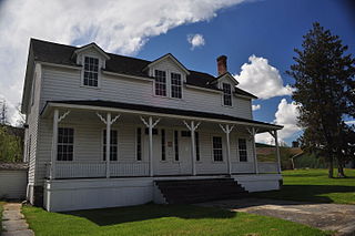
WFort Lapwai (1862–1884), was a federal fort in present-day Lapwai in north central Idaho, United States. On the Nez Perce Indian Reservation in Nez Perce County, it was originally called Camp Lapwai until 1863. East of Lewiston, it was located on the west bank of Lapwai Creek, three miles (5 km) above where it joins the Clearwater River at the state's first settlement, Lapwai Mission Station, built in 1836 by Henry Spalding. It is part of the multi-site Nez Perce National Historical Park. The word "Lapwai" means place of the butterflies, as the area had thousands in early summer in earlier years.
 W
WJoseph Canyon is a 2,000-foot (610 m)-deep basalt canyon in northern Wallowa County, Oregon, and southern Asotin County, Washington, United States.
 W
WThe Old Chief Joseph Gravesite, also known as Nez Perce Traditional Site, Wallowa Lake, Chief Joseph Cemetery and Joseph National Indian Cemetery is a Native American cemetery near Joseph, Oregon. The area was also a traditional campsite of the Nez Perce and may be archaeologically significant. It was declared a National Historic Landmark in 1985, listed as Wallowa Lake Site. It is a component of the Nez Perce National Historical Park.
 W
WWeippe Prairie is a "beautiful upland prairie field of about nine by twenty miles of open farmland bordered by pine forests" at 3,000 feet elevation in Clearwater County, Idaho, at Weippe, Idaho. Camas flowers grow well there, and attracted native gatherers of the camas roots. It is the location in Idaho where the Lewis and Clark Expedition emerged from crossing the Bitterroot Mountains on the Lolo Trail and first met the Nez Perce tribe of Native Americans.