 W
WThe Ardagh–Johnson Line is the northeastern boundary of Kashmir drawn by surveryor William Johnson and recommended by John Charles Ardagh as the official boundary of India. It abuts China's Xinjiang and Tibet autonomous regions.
 W
WThe Collins–Valentine line, or Valentine–Collins line, is the boundary at approximately 45 degrees north latitude that separates the province of Quebec from the states of New York and Vermont. It was surveyed and marked by survey monuments in 1771–3 by John Collins, surveyor-general of Quebec, and Thomas Valentine, a commissioner appointed by the government of New York.
 W
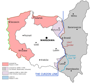
WThe Curzon Line was a proposed demarcation line between the Second Polish Republic and the Soviet Union, two new states emerging after World War I. It was first proposed by the British Foreign Secretary George Curzon to the Supreme War Council in 1919 as a diplomatic basis for a future border agreement.
 W
WDmowski's Line was a proposed border of Poland after World War I. It was proposed by the Polish delegation at the Paris Peace Conference of 1919 and it was named after Roman Dmowski, Polish foreign minister. Poland wanted Upper Silesia, Pomerelia including Danzig, Warmia and Masuria, all of Lithuania, and western parts of Belarus, Polesia, Volhynia and Podolia.
 W
WThe Durand Line is the 2,670 km (1,660 mi) international land border between Afghanistan and Pakistan in South Asia. It was originally established in 1893 as the international border between British India and the Emirate of Afghanistan by Mortimer Durand, a British diplomat of the Indian Civil Service, and Abdur Rahman Khan, the Afghan Emir, to fix the limit of their respective spheres of influence and improve diplomatic relations and trade.
 W
WThe Foch Line was a temporary demarcation line between Poland and Lithuania proposed by the Entente in the aftermath of World War I. The line was proposed by Marshal of France Ferdinand Foch and was accepted by the Conference of Ambassadors in 1919. With small adjustments the line formed the basis of the inter-war Polish-Lithuanian border. The line left Vilnius (Wilno) on the Polish side. After World War II only its westernmost part, close to the town of Suwałki, follows the line.
 W
WThe Keith line was a line drawn through the Province of New Jersey, dividing it into the Province of West Jersey and the Province of East Jersey. The line was created by Surveyor-General George Keith in 1686, when he ran the first survey to mark out the border between West Jersey and East Jersey. The Keith line was intended to clarify disputes resulting from the 1676 Quintipartite Deed, which created the two territories.
 W
WThe Macartney–MacDonald Line is a proposed boundary in the disputed area of Aksai Chin. It was proposed by British Indian Government to China in 1899 via its envoy to China, Sir Claude MacDonald. The Chinese Government never gave any response to the proposal. The Indian Government believed that, subsequently British India reverted to its traditional boundary, the Johnson–Ardagh Line. Independent scholars have not confirmed the claim.
 W
WThe Mason–Dixon line, also called the Mason and Dixon line or Mason's and Dixon's line, is a demarcation line separating four U.S. states, forming part of the borders of Pennsylvania, Maryland, Delaware, and West Virginia. Historically, it came to be seen as demarcating the North from the South in the U.S. It was surveyed between 1763 and 1767 by Charles Mason and Jeremiah Dixon in the resolution of a border dispute involving Maryland, Pennsylvania, and Delaware in Colonial America. The dispute had its origins almost a century earlier in the somewhat confusing proprietary grants by King Charles I to Lord Baltimore (Maryland) and by King Charles II to William Penn.
 W
WThe McMahon Line is the boundary between Tibet and British India as agreed in the maps and notes exchanged by the respective plenipotentiaries on 24-25 March 1914 at Delhi, as part of the 1914 Simla Convention. The Republic of China was not a party to the McMahon Line agreement, but the line was part of the overall boundary of Tibet defined in the Simla Convention, initialled by all three parties and quickly repudiated by the government of China. The Indian part of the Line currently serves as the de facto boundary between China and India, although its legal status is disputed by the People's Republic of China. The Burmese part of the Line was renegotiated by the People's Republic of China and Myanmar.
 W
WThe Radcliffe Line was the boundary demarcation line between the Indian and Pakistani portions of the Punjab and Bengal provinces of British India. It was named after its architect, Sir Cyril Radcliffe, who, as the joint chairman of the two boundary commissions for the two provinces, received the responsibility to equitably divide 175,000 square miles (450,000 km2) of territory with 88 million people.
 W
WThe Sullivan Line originally marked in 1816 forms three quarters of the border between Missouri and Iowa and an extension of it forms the remainder. The line was initially created to establish the limits of Native American territory ; disputes over the boundary were to erupt into the Honey War.
 W
WThe Syngman Rhee Line refers to a marine boundary line established by South Korean President Syngman Rhee in his "Peace Line" declaration of January 18, 1952, establishing a wide area of maritime sovereignty, beyond internationally accepted territorial waters, around the entire Korean Peninsula. This included placing the Liancourt Rocks (Dokdo/Takeshima) in South Korean territory.