 W
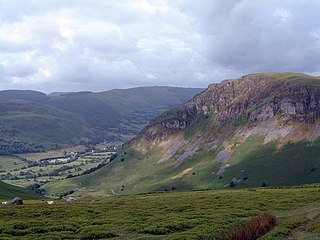
WAllt yr Esgair is a hill in the Brecon Beacons National Park in Powys, Wales. It is commonly referred to locally as simply 'The Allt'. The Welsh name signifies 'wooded slope of the ridge'. It takes the form of a northwest-southeast aligned ridge which rises to a height of 393m and which overlooks the valley of the River Usk to the west and south. To the northeast are panoramic views across Llangorse Lake to the Black Mountains There is a viewfinder on the summit erected as a monument to Eirene Lloyd White, Baroness White of Rhymney. It is a Marilyn with a prominence of 199 metres.
 W
WLong Mountain is a hill straddling the boundary between Powys (Wales) and Shropshire (England) to the east of Welshpool though the summit at 408 metres at Beacon Ring is within Wales. Long Mountain is a Marilyn, having a prominence of 305 metres.
 W
WBreidden Hill is an extinct volcanic hill in Powys, Wales, near the town of Welshpool. It is immediately surrounded by the villages of Trewern, Middletown, Criggion, Crew Green and Llandrinio. The peak of the hill reaches to 367 metres (1,204 ft). Footpaths which lead up to the summit provide excellent 360 degree views over Powys and over the border with England to the Shropshire Plain.
 W
WBurfa Castle is an Iron Age hillfort near the tiny town of Old Radnor, Radnorshire in Powys, Wales. The site is a scheduled monument described as a prehistoric defensive hillfort, and was included in an inventory of monuments by 1913. The site is near Offa's Dyke which passes near the bottom of Burfa Bank.
 W
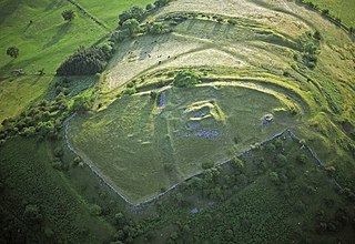
WCefn Carnedd is an Iron Age hillfort, about 1.5 miles (2 km) south-west of Caersws, in Powys, Wales. It is a scheduled monument.
 W
WCraig Rhiwarth is a mountain in the Berwyn range, in Powys, Wales, overlooking the village of Llangynog to the south. On the summit is an Iron Age hillfort, and there are remains of slate quarrying on the southern slopes.
 W
WCrug Hywel is a flat-topped mountain at the southern edge of the Black Mountains in south-east Wales. It rises to 451 m above sea level, from the southern flank of Pen Cerrig-calch (701 m), and overlooks the town of Crickhowell, to which it gives its name. The name is from Welsh crug, a hillock, and hywel, conspicuous.
 W
WCastell Dinas is a hillfort and castle in southern Powys, Wales. At 450 m (SO179301) it has the highest castle in England and Wales. It is positioned to defend the Rhiangoll pass between Talgarth and Crickhowell.
 W
WFfridd Faldwyn is an Iron Age Hillfort in northern Powys, in the former county of Montgomeryshire, It is sited on a prominent hill west of Montgomery, close to but higher than Montgomery Castle, overlooking the River Severn. It is one of the largest hill-forts in Wales.
 W
WLlwyn Bryn-Dinas is an Iron Age hillfort on the north side of the Tanat valley, about 1 mile (1.6 km) west of the village of Llangedwyn, in Powys, Wales.
 W
WMynydd Illtud is an extensive area of common land near Libanus, Powys, Wales, located in the Brecon Beacons National Park and some three miles south-west of Brecon. The common is an undulating plateau lying between 330 and 370 metres above sea level. Its highest points are 381 metres (1,250 ft) at Allt Lom and 367 metres (1,204 ft) at Twyn y Gaer trig point overlooking the valley of the River Usk. Twyn y Gaer is the site of an Iron Age hill fort.
 W
WPen-y-crug is a hill in the Brecon Beacons National Park in the county of Powys, south Wales. It is commonly referred to locally as simply 'The Crug'. The Welsh name signifies 'top of the mound'. It slopes are moderately gently on three sides; only to the west do they steepen somewhat. Its flat trig point adorned summit at 331m overlooks the valley of the River Usk to the south. To the southeast are panoramic views over Brecon whilst eastwards are the Black Mountains and south the Brecon Beacons.
 W
WPentre Camp is an Iron Age hillfort, near the hamlet of Llangynyw and about 2.5 miles (4 km) north-east of Llanfair Caereinion, in Powys, Wales. It is a scheduled monument.
 W
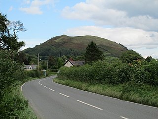
WRoundton Hill is a rounded, steep sided, 1,210 feet (370 m) hill, volcanic in origin, in the easternmost part of old Montgomeryshire, Wales, which juts into the English border near Church Stoke. It is managed as a nature reserve by the Montgomeryshire Wildlife Trust, who acquired it in 1985.
 W
WSlwch Tump, also known as Slwch Camp and formerly known as Pen Cevn-y-Gaer, is an Iron Age hillfort close to Brecon in Powys, Wales.