 W
WThere are twelve provinces of the Netherlands, representing the administrative layer between the national government and the local municipalities, with responsibility for matters of subnational or regional importance.
 W
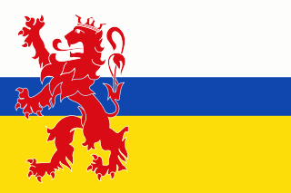
WThe coats of arms of the twelve provinces of the Netherlands are shown here.
 W
WThis list contains all twelve official flags of provinces of the Netherlands, including the pennons.
WThe Politics of the Dutch provinces takes places within the framework of the politics of the Netherlands. The province is the second-highest level of government, after the national government. The Netherlands is divided into twelve provinces.
 W
WDrenthe is a province of the Netherlands located in the northeastern part of the country. It is bordered by Overijssel to the south, Friesland to the west, Groningen to the north, and the German state of Lower Saxony to the east. As of November 2019, Drenthe had a population of 493,449 and a total area of 2,680 km2 (1,030 sq mi).
 W
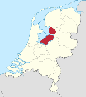
WFlevoland is the 12th and youngest province of the Netherlands, established in 1986, when the Southern and Eastern Flevopolders, together with the Noordoostpolder were merged into one provincial entity. It is in the centre of the country in the former Zuiderzee, which was turned into the freshwater IJsselmeer by the closure of the Afsluitdijk in 1932. Almost all of the land belonging to Flevoland was reclaimed in the 1950s and 1960s while splitting the Markermeer and Bordering lakes from the IJsselmeer. As to dry land, it is the smallest province of the Netherlands at 1,412 km2 (545 sq mi), but not gross land as that includes much of the waters of the fresh water lakes (meres) mentioned. The province has a population of 423,021 as of January 2020 and consists of six municipalities. Its capital is Lelystad and its most populous city is Almere.
 W
WFriesland, historically known as Frisia, is a province of the Netherlands located in the northern part of the country. It is situated west of Groningen, northwest of Drenthe and Overijssel, north of Flevoland, northeast of North Holland, and south of the Wadden Sea. As of January 2020, the province had a population of 649,944 and a total area of 5,749 km2 (2,220 sq mi).
 W
WGelderland, also known as Guelders in English, is a province of the Netherlands, occupying the centre-east of the country. With a total area of 5,136 km2 (1,983 sq mi) of which 173 km2 (67 sq mi) is water, it is the largest province of the Netherlands. Gelderland shares borders with six other provinces and the German state of North Rhine-Westphalia.
 W
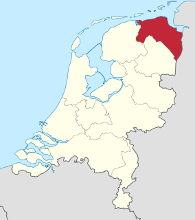
WGroningen is the northeasternmost province of the Netherlands. It borders on Friesland to the west, Drenthe to the south, the German state of Lower Saxony to the east, and the Wadden Sea to the north. As of November 2019, Groningen had a population of 585,881 and a total area of 2,960 km2 (1,140 sq mi).
 W
WLimburg is the southernmost of the 12 provinces of the Netherlands. The province is bordered by the province of Gelderland to the north and by North Brabant to its west. Its long eastern boundary forms the international border with Germany. Much of the western and southern boundary is the international border with Belgium, much of it delineated by the river Meuse. There is a Belgian province that is also named Limburg. The Vaalserberg is on the extreme south-eastern point, marking the tripoint of the Netherlands, Germany and Belgium.
 W
WNorth Brabant, also unofficially called Brabant, is a province in the south of the Netherlands. It borders the provinces of South Holland and Gelderland to the north, Limburg to the east, Zeeland to the west, and the Flemish provinces of Antwerp and Limburg to the south. The northern border follows the Meuse westward to its mouth in the Hollands Diep strait, part of the Rhine–Meuse–Scheldt delta. North Brabant has a population of 2,562,566 as of November 2019. Major cities in North Brabant are Eindhoven, Tilburg, Breda and its provincial capital 's-Hertogenbosch.
 W
WNorth Holland is a province of the Netherlands in the northwestern part of the country. It is located on the North Sea, north of South Holland and Utrecht, and west of Friesland and Flevoland. In November 2019, it had a population of 2,877,909 and a total area of 4,092 km2 (1,580 sq mi), of which 1,430 km2 (550 sq mi) is water.
 W
WOverijssel is a province of the Netherlands located in the eastern part of the country. The province's name translates to "across the IJssel", from the perspective of the Episcopal principality of Utrecht by which it was held until 1528. The capital city of Overijssel is Zwolle and the largest city is Enschede. The province had a population of 1,162,215 as of November 2019.
 W
WSouth Holland is a province of the Netherlands with a population of just over 3.7 million as of November 2019 and a population density of about 1,373/km2 (3,560/sq mi), making it the country's most populous province and one of the world's most densely populated areas. Situated on the North Sea in the west of the Netherlands, South Holland covers an area of 3,419 km2 (1,320 sq mi), of which 605 km2 (234 sq mi) is water. It borders North Holland to the north, Utrecht and Gelderland to the east, and North Brabant and Zeeland to the south. The provincial capital is the Dutch seat of government The Hague, while its largest city is Rotterdam. The Rhine-Meuse-Scheldt delta drains through South Holland into the North Sea. Europe's busiest seaport, the Port of Rotterdam, is located in South Holland.
 W
WUtrecht, officially the Province of Utrecht, is a province of the Netherlands. It is located in the centre of the country, bordering the Eemmeer in the north-east, the province of Gelderland in the east and south-east, the province of South Holland in the west and south-west and the province of North Holland in the north-west and north. The province of Utrecht has a population of 1,353,596 as of November 2019. It has a land area of approximately 1,485 square kilometres (573 sq mi). Apart from its eponymous capital, major cities in the province are Amersfoort, Houten, Nieuwegein, Veenendaal, IJsselstein and Zeist. The busiest railway station in the Netherlands, Utrecht Centraal, is located in the province of Utrecht.
 W
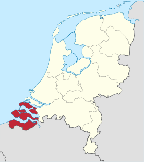
WZeeland is the westernmost and least populous province of the Netherlands. The province, located in the south-west of the country, borders North Brabant to the east, South Holland to the north, and the country of Belgium to the south and west. It consists of a number of islands and peninsulas and a strip bordering the Flemish provinces of East and West Flanders. Its capital is Middelburg with a population of 48,544 as of November 2019, the largest municipality in Zeeland is Terneuzen. Zeeland has two seaports: Vlissingen and Terneuzen. Its area is 2,934 square kilometres (1,130 sq mi), of which 1,151 square kilometres (440 sq mi) is water, and it has a population of 383,689 as of November 2019.