 W
WGreenwood is a city in south central British Columbia. It was incorporated in 1897 and was formerly one of the principal cities of the Boundary Country smelting and mining district. It was incorporated as a city originally and has retained that title despite the population decline following the closure of the area's industries.
 W
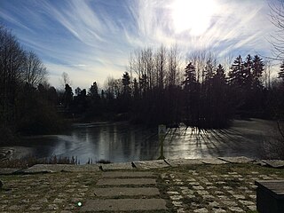
WHastings Park is located in the northeast sector of Vancouver, British Columbia, Canada, in a neighbourhood called Hastings-Sunrise. Its name references the Hastings Townsite, part of which was also known as New Brighton, which lay at the end of the Douglas Road from New Westminster, founded as a resort and watering-hole and as a port to connect the other settlements of the inlet—Gastown, Moodyville and Barnet—to the city.
 W
WKananaskis Village is an unincorporated community in Alberta's Rockies within the Kananaskis Country park system in the Kananaskis Improvement District of Alberta, Canada. It is located approximately 26 km (16 mi) south of the Trans-Canada Highway, 3 km (1.9 mi) west of Highway 40 via Mt. Allan Drive and Centennial Drive. The community is located on the west shore of the Kananaskis River at the base of Mount Kidd.
 W
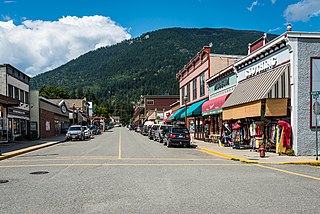
WKaslo is a village on the west shore of Kootenay Lake in the West Kootenay region of southeastern British Columbia. A member municipality of the Central Kootenay Regional District, the name derives from the adjacent Kaslo River. At 2016, the population was 968, and the idyllic village is regarded at the "Little Switzerland of Canada"
 W
WLillooet, formerly Cayoosh Flat, is a community on the Fraser River in British Columbia, Canada, about 240 km (150 mi) up the British Columbia Railway line from Vancouver. Situated at an intersection of deep gorges in the lee of the Coast Mountains, it has a dry climate with an average of 329.5 mm (12.97 in) of precipitation being recorded annually. Lillooet has a long growing season, and once had prolific market gardens and orchard produce. It often vies with Lytton and Osoyoos for the title of "Canada's Hot Spot" on a daily basis in summer.
 W
WMcGillivray, formerly McGillivray Falls, is an unincorporated recreational community on the west shore of Anderson Lake, just east of midway between the towns of Pemberton and Lillooet, British Columbia, Canada, in that province's southwest Interior.
WMinto City, often called just Minto, sometimes Minto Mines or Minto Mine, was a gold mining town in the Bridge River Valley of British Columbia from 1930 to 1936, located at the confluence of that river with Gun Creek, one of its larger tributaries. It was first called the Alpha group of claims in the 1920s, when underground miners were exploring the seams of Cadwallader Creek and the origins of the placer deposits downstream in the Bridge River. The mine prospect was never much successful although a model townsite was built by promoter "Big Bill" Davidson, who imported soil to build a specially-built rodeo ground and baseball diamond on the rocky site. The larger mine of Bralorne was nearby. The mine shut down in 1936 due to productivity issues, but restarted in 1940. The valley has since been significantly altered when most of the vestiges of the town were inundated by the waters of the Carpenter Lake reservoir following completion of the Bridge River Power Project. The town sat on the western end of the lake near the present Carpenter Lake Road, part of the road drove through a wooden Tudor arch built into the rock mill.
 W
WMinto is a Canadian village straddling the border of Sunbury County and Queens County, New Brunswick. It is located on the north shore of Grand Lake, approximately 50 kilometres northeast of Fredericton. Its population meets the requirements for "town" status under the Municipalities Act of the Province of New Brunswick, but the community has not made any change in municipal status.
WNew Denver is at the mouth of Carpenter Creek, on the east shore of Slocan Lake, in the West Kootenay region of southeastern British Columbia. The village is 47 kilometres (29 mi) west of Kaslo on Highway 31A, and 47 kilometres (29 mi) southeast of Nakusp and 32 kilometres (20 mi) northeast of Slocan on Highway 6.
 W
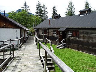
WNikkei Internment Memorial Centre is a museum that preserves and interprets one of ten Canadian concentration camps where more than 27,000 Japanese Canadians were incarcerated by the Canadian government during and after World War II. The centre was designated a National Historic Site of Canada in 2007.
 W
WÎle aux Noix is an island on the Richelieu River in Quebec, close to Lake Champlain. The island is the site of Fort Lennox National Historic Site of Canada. Politically, it is part of Saint-Paul-de-l'Île-aux-Noix.
WRosebery is an unincorporated community about 6 kilometres (4 mi) north of New Denver in the West Kootenay region of southeastern British Columbia. The former steamboat landing and ferry terminal is at the mouth of Wilson Creek on the eastern shore of Slocan Lake. The locality, on BC Highway 6, is about 106 kilometres (66 mi) by road north of Castlegar and 144 kilometres (89 mi) by road and ferry south of Revelstoke.
 W
WSandon is in the foothills of the Selkirk Mountains in the West Kootenay region of southeastern British Columbia. The near ghost town lies off BC Highway 31A, and is at the confluence of Sandon Creek into Carpenter Creek. By road, the place is about 14 kilometres (9 mi) east of New Denver and 43 kilometres (27 mi) west of Kaslo.
WShalalth, pop. c. 400, is one of the main communities of the Seton Lake Band of the St'at'imc (Lillooet) Nation and location of the two main powerhouses of the Bridge River Power Project.
 W
WThe Village of Slocan is in the West Kootenay region of southeastern British Columbia. The former steamboat landing and ferry terminal is at the mouth of Springer Creek, at the foot of Slocan Lake. The locality, on BC Highway 6 is about 69 kilometres (43 mi) by road north of Castlegar and 183 kilometres (114 mi) by road and ferry south of Revelstoke.
 W
WSunshine Valley is an unincorporated community consisting of cabins, tiny homes, and RV parks on the Crowsnest Highway between the town of Hope (NW) and the entrance to Manning Park in the Cascade Mountains of British Columbia. The community has its own volunteer fire department (SVVFD), recreation centre, heated outdoor pool, and playground. As of 2016, the population of Sunshine Valley is 177.