 W
WAigialeia is a municipality and a former province (επαρχία) in the eastern part of the Achaea regional unit, Greece. The seat of the municipality is the town Aigio. The municipality has an area of 723.063 km2. The main towns are Aigio, Akrata and Diakopto. The municipality Aigialeia stretches from the south coast of the Gulf of Corinth to the mountainous interior of the Peloponnese peninsula. The main rivers of the municipality are the Selinountas and the Vouraikos.
 W
WAktio–Vonitsa is a municipality in the Aetolia-Acarnania regional unit of the West Greece region of Greece. Its seat is the town of Vonitsa. The municipality has an area of 660.172 km2.
 W
WAmfilochia is a town and a municipality in the northwestern part of Aetolia-Acarnania in Greece, on the site of ancient Amfilochia. Under the Ottoman Empire, it was known as Karvasaras.
 W
WAndravida–Kyllini is a municipality in the Elis regional unit, West Greece region, Greece. The seat of the municipality is the town Lechaina. The municipality has an area of 355.476 km2.
 W
WAndritsaina–Krestena is a municipality in the Elis regional unit, West Greece region, Greece. The seat of the municipality is the town Krestena. The municipality has an area of 422.334 km2.
 W
WErymanthos is a municipality in the Achaea regional unit, Western Greece region, Greece. The seat of the municipality is the town Chalandritsa. The municipality has an area of 582.139 km2. It was named after Mount Erymanthos.
 W
WIlida is a municipality in the Elis regional unit, West Greece region, Greece. The seat of the municipality is the town Amaliada. The municipality has an area of 400.517 km2. It was named after the ancient region and city Elis.
 W
WKalavryta is a town and a municipality in the mountainous east-central part of the regional unit of Achaea, Greece. The town is located on the right bank of the river Vouraikos, 24 kilometres south of Aigio, 40 km southeast of Patras and 62 km northwest of Tripoli. Notable mountains in the municipality are Mount Erymanthos in the west and Aroania or Chelmos in the southeast. Kalavryta is the southern terminus of the Diakopto-Kalavryta rack railway, built by Italian engineers between 1885 and 1895.
 W
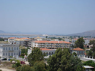
WMessolonghi or Missolonghi is a municipality of 34,416 people in western Greece. The town is the capital of Aetolia-Acarnania regional unit, and the seat of the municipality of Iera Polis Messolongiou. Messolonghi is known as the site of a dramatic siege during the Greek War of Independence, and of the death of poet Lord Byron.
 W
WNafpaktia, Latinized Naupactia, is the historical name for the region around the port town of Nafpaktos (Naupactus) in Central Greece.
 W
WOlympia, officially Archaia Olympia, is a small town in Elis on the Peloponnese peninsula in Greece, famous for the nearby archaeological site of the same name, which was a major Panhellenic religious sanctuary of ancient Greece, where the ancient Olympic Games were held every four years throughout Classical antiquity, from the 8th century BC to the 4th century AD. They were restored on a global basis in 1894 in honor of the ideal of peaceful international contention for excellence.
 W
WPatras is Greece's third-largest city and the regional capital of Western Greece, in the northern Peloponnese, 215 km (134 mi) west of Athens. The city is built at the foot of Mount Panachaikon, overlooking the Gulf of Patras.
 W
WPineios is a municipality in the Elis regional unit, West Greece region, Greece. The seat of the municipality is the town Gastouni. The municipality has an area of 161.496 km2. It was named after the river Pineios.
 W
WPyrgos is a city in the northwestern Peloponnese, Greece, capital of the regional unit of Elis and the seat of the Municipality of Pyrgos. The city is located in the middle of a plain, 4 kilometres from the Ionian Sea. The river Alfeios flows into sea about 7 km (4 mi) south of Pyrgos. The population of the town Pyrgos is 25,180, and of the municipality 47,995 (2011). Pyrgos is 16 km (10 mi) west of Olympia, 16 km (10 mi) southeast of Amaliada, 70 km (43 mi) southwest of Patras and 85 km (53 mi) west of Tripoli.
 W
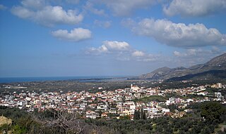
WThermo is a town and a municipality in Aetolia-Acarnania, Greece. It is located in the southeastern part of the regional unit, largely between Lake Trichonida and the southern border of Evrytania. It has a land area of 333.701 km2 (129 sq mi) and a population of 8,242 inhabitants.
 W
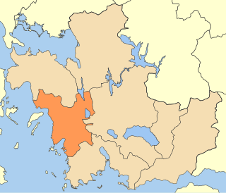
WWest Achaea is a municipality in the Achaea regional unit, West Greece region, Greece. The seat of the municipality is the town Kato Achaia. The municipality has an area of 573.30 km2.
 W
WXiromero municipality is a municipality in the Aetolia-Acarnania regional unit, West Greece region, Greece. The seat of the municipality is the town Astakos. Its borders do not coincide with the historical region of Xiromero, which extends to parts of the territory of the neighbouring municipality of Aktio-Vonitsa and most notably the area around Katouna. The municipality has an area of 590.113 km2.
 W
WZacharo is a town and municipality in western Peloponnese, Greece. Administratively, it belongs to the regional unit of Elis in West Greece. Zacharo is situated on the coast of the Gulf of Kyparissia, a part of the Ionian Sea. The mountain Lapithas is to the north, and the Minthi is to the east. Northwest of the town, between mount Lapithas and the sea, is the Kaiafas Lake. Zacharo is 18 km south of Olympia, 28 km southeast of Pyrgos, 65 km northwest of Kalamata and 65 km west of Tripoli. The town is crossed by the Greek National Road 9/E55, that links Patras with Kalamata.