 W
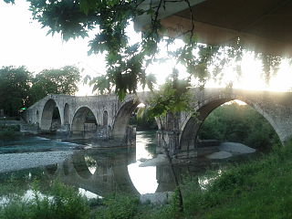
WArta is a city in northwestern Greece, capital of the regional unit of Arta, which is part of Epirus region. The city was known in ancient times as Ambracia. Arta is known for the medieval bridge over the Arachthos River. Arta is also known for its ancient sites from the era of Pyrrhus of Epirus and its well-preserved 13th-century castle. Arta's Byzantine history is reflected in its many Byzantine churches; perhaps the best known is the Panagia Paregoretissa, built about 1290 by Despot Nikephoros I Komnenos Doukas.
 W
WCentral Tzoumerka is a municipality in the Arta regional unit, Epirus, Greece. The seat of the municipality is the village Vourgareli. The municipality has an area of 509.231 km2. The municipality is named after the Tzoumerka mountains.
 W
WDodoni is a village and a municipality in the Ioannina regional unit, Epirus, Greece. The seat of the municipality is the village Agia Kyriaki.
 W
WFiliates is a town and a municipality in Thesprotia, Greece. It is located in the northernmost part of the regional unit, bordering western Ioannina regional unit and southern Albania.
 W
WGeorgios Karaiskakis is a municipality in the regional unit of Arta, Greece, named after Georgios Karaiskakis, a leader of the Greek War of Independence. The seat of the municipality is in Ano Kalentini.
 W
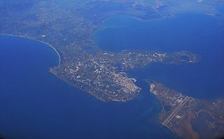
WIgoumenitsa is a coastal city in northwestern Greece. It is the capital of the regional unit of Thesprotia.
 W
WIliochori is one of the Zagori villages in northwest Greece. It is located in the municipal unit of Tymfi in the northern part of the regional unit of Ioannina. According to a local legend, the village was founded as Rasciana, on the river of the same name. However, that site was abandoned because of a lack of drinking water, and the inhabitants scattered to found Iliochori and the nearby town of Laista. Iliochori was traditionally an agricultural village, with husbandry and cultivation of barley and vetch being among its primary areas of economic activity. Viticulture was also prominent, and the village produced a wine, Dobrovino, that gave it its original name. Caravans leaving from Iliochori carried products from the region to the Balkans for trade. The town suffered severe damage in both World War II and the Greek Civil War and lost a large portion of its population during the 1940s as a result.
 W
WIoannina, often called Yannena within Greece, is the capital and largest city of the Ioannina regional unit and of Epirus, an administrative region in north-western Greece. According to the 2011 census, the city population was 65,574, while the municipality had 112,486 inhabitants. It lies at an elevation of approximately 500 metres above sea level, on the western shore of lake Pamvotis (Παμβώτις). Ioannina is located 410 km (255 mi) northwest of Athens, 260 kilometres southwest of Thessaloniki and 80 km east of the port of Igoumenitsa in the Ionian Sea.
WKonitsa is a town of Ioannina in Epirus, Greece. It is located north of the capital Ioannina and near the Albanian border. Northeast of Konitsa lies a group of villages known as the Zagorochoria. The town was built amphitheatrically-shaped on a mountain slope of the Pindos mountain range from where it overlooks the valley where the river Aoos meets the river Voidomatis.
 W
WMetsovo is a town in Epirus, in the mountains of Pindus in northern Greece, between Ioannina to the west and Meteora to the east.
 W
WNikolaos Skoufas is a municipality in the regional unit of Arta, Greece, named after Nikolaos Skoufas, a leader of the Greek independence movement. The seat of the municipality is in Peta. The municipality has an area of 231.842 km2.
 W
WNorth Tzoumerka is a municipality in the Ioannina regional unit, Epirus, Greece. The seat of the municipality is the village Pramanta. The municipality has an area of 358.334 km2. The municipality is named after the Tzoumerka mountains.
 W
WParga is a town and municipality located in the northwestern part of the regional unit of Preveza in Epirus, northwestern Greece. The seat of the municipality is the village Kanallaki. Parga lies on the Ionian coast between the cities of Preveza and Igoumenitsa. It is a resort town known for its natural environment.
 W
WPogoni is a municipality in the Ioannina regional unit, Epirus, Greece. The seat of the municipality is the village Kalpaki. The municipality has an area of 701.059 km2. Its population was 8,960 at the 2011 census.
 W
WPreveza is a city in the region of Epirus, northwestern Greece, located on the northern peninsula at the mouth of the Ambracian Gulf. It is the capital of the regional unit of Preveza, which is part of the region of Epirus. The Aktio-Preveza Immersed Tunnel – the first and so far only undersea tunnel in Greece – was completed in 2002 and connects Preveza in the north to Aktio in western Acarnania in Aetolia-Acarnania south of the mouth of the Ambracian Gulf. The ruins of the ancient city of Nicopolis lie 7 kilometres north of the city.
 W
WSouli is a municipality in Epirus, northwestern Greece. The seat of the municipality is the town of Paramythia.
 W
WZagori, is a region and a municipality in the Pindus mountains in Epirus, in northwestern Greece. The seat of the municipality is the village Asprangeloi. It has an area of some 1,000 square kilometers and contains 46 villages known as Zagori villages, and is in the shape of an upturned equilateral triangle. Ioannina, the provincial capital, is at the southern point of the triangle, while the south-western side is formed by Mount Mitsikeli (1,810m). The Aoos river running north of Mt Tymphe forms the northern boundary, while the south-eastern side runs along the Varda river to Mount Mavrovouni (2,100m) near Metsovo. The municipality has an area of 989.796 km2. The population of the area is about 3,700, which gives a population density of 4 inhabitants per square kilometer, very sparse when compared to an average of 73.8 for Greece as a whole.
 W
WZiros is a municipality in the Preveza regional unit, Epirus, Greece. The seat of the municipality is the village Filippiada. The municipality has an area of 380.601 km2.
 W
WZitsa is a village and a municipality in the Ioannina regional unit, Epirus, Greece. The seat of the municipality is the village Eleousa. The municipality has an area of 565.566 km2, the municipal unit 65.868 km2, the community 29.169 km2.