 W
WHadrian's Wall, also known as the Roman Wall, Picts' Wall, or Vallum Hadriani in Latin, is a former defensive fortification of the Roman province of Britannia, begun in AD 122 in the reign of the emperor Hadrian. Running "from Wallsend on the River Tyne in the east to Bowness-on-Solway in the west", the Wall covered the whole width of the island, as Jarrett A. Lobell says. In addition to the wall's defensive military role, its gates may have been customs posts.
 W
WThe Corbridge Lion, Northumberland, England, is an ancient Roman free-standing sandstone sculpture of a male lion standing on a prone animal on a semi-cylindrical coping stone base. Measuring 0.95m in length by 0.36m in width and 0.87m high, it was originally a piece of decorative funerary ornamentation from a tomb. It was subsequently re-used as a fountainhead by passing a water pipe through its mouth. It was found in a water tank in 1907 in excavations led by Leonard Woolley on Site II on the Roman site at Corbridge. It is believed to date to the 2nd or 3rd centuries AD.
 W
WCoventina was a Romano-British goddess of wells and springs. She is known from multiple inscriptions at one site in Northumberland county of England, an area surrounding a wellspring near Carrawburgh on Hadrian's Wall. It is possible that other inscriptions, two from Hispania and one from Narbonensis, refer to Coventina, but this is disputed.
 W
WCuneus Frisionum or Frisiorum cuneus are the names of units of Frisian auxiliaries in the Roman army.
 W
WHadrian's Wall Path is a long-distance footpath in the north of England, which became the 15th National Trail in 2003. It runs for 84 miles (135 km), from Wallsend on the east coast of England to Bowness-on-Solway on the west coast. For most of its length it is close to the remains of Hadrian's Wall, the defensive wall built by the Romans on the northern border of their empire. This is now recognised as part of the "Frontiers of the Roman Empire" World Heritage Site.
The Hadrianic Society was a British historical society focused upon Hadrian's Wall and Roman Britain as well as the Antonine Wall, the Gask Ridge, and other Roman Frontier systems. It was founded in 1971 under the leadership of Brian Dobson, David Breeze, and Valerie Maxfield. The Hadrianic Society closed in 2018. Some of its functions continue to be fulfilled by the Roman Army School.
Illuminating Hadrian's Wall was a public event on Hadrian's Wall which took place on 13 March 2010 and saw the route of the wall lit with beacons. The event was organised by Hadrian's Wall Heritage Ltd. and coincided with the 1600th anniversary of the End of Roman rule in Britain.
 W
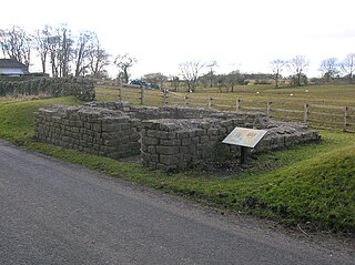
WThe Knag Burn Gateway is a gateway which was built into Hadrian's Wall some time after construction of the wall itself, generally acknowledged to be during the fourth century.
 W
WLeahill Turret is a typical example of one of the lookout towers located between the milecastles on Hadrian's Wall in Cumbria; located on the Lanercost Road near Banks, Parish of Waterhead. It is designated turret 51b and lies east of the Signal Tower at Pike Hill.
 W
WLimestone Corner is an area of Hadrian's Wall at its most northerly point, in present-day northern England. It represents the most northerly point of the Roman Empire, outside the two periods during which the Antonine Wall was occupied by the Roman military. Other notable features at Limestone Corner are the wall ditch at this point, which was never completely excavated, a Roman camp and the site of Milecastle 30. Also present is a trig point. The B6318 Military Road also runs through Limestone Corner, as does the Military Way, serving Milecastle 30. The Military Way is visible on the ground at this point, the most eastern point where this is the case.
 W
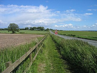
WThe Military Road is a name given locally to part of the B6318 road in Northumberland, England, which runs from Heddon-on-the-Wall (54.9974°N 1.7929°W) in the east to Greenhead (54.9820°N 2.5344°W) in the west.
 W
WThe Military Way is the modern name given to a Roman road constructed immediately to the south of Hadrian's Wall.
 W
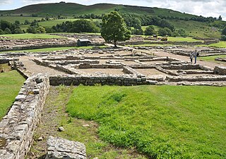
WPike Hill Signal Tower was one of a number of signal stations that were built on high ground overlooking the line of the Roman Stanegate road in northern Britannia during the early 2nd century. It later became incorporated into Hadrian's Wall. Its remains, a 2-metre long fragment of the south-east wall, lie south of a modern road cutting and field wall, and are located in the parish of Waterhead in Cumbria, United Kingdom. The tower is located between Turret 51B and Turret 52A with the fort of Banna located to the east.
 W
WPlanetrees is an extant section of Hadrian's Wall named after the farm located around 250 metres (270 yd) to the west. The surviving section is 35 metres (115 ft) in length.
 W
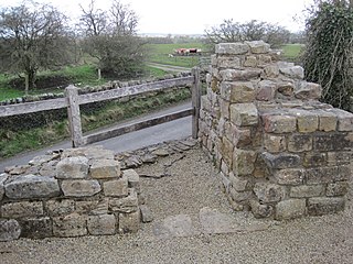
WThe Portgate was a fortified gateway, constructed as part of Hadrian's Wall where it crossed the Roman road now known as Dere Street, which preceded Hadrian's Wall by around 50 years. It was built to control traffic along Dere Street as it passed north through Hadrian's Wall. The gate's remains exist beneath the old B6318 Military Road to the south-west of the Stagshaw Roundabout.
 W
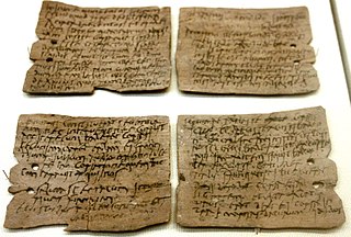
WClaudia Severa was a literate Roman woman, the wife of Aelius Brocchus, commander of an unidentified fort near Vindolanda fort in northern England. She is known for a birthday invitation she sent around 100 AD to Sulpicia Lepidina, wife of Flavius Cerialis, commander at Vindolanda. This invitation, written in ink on a thin wooden tablet, was discovered in the 1970s and is probably the best-known item of the Vindolanda Tablets.
 W
WThe Staffordshire Moorlands Pan, sometimes known as the Ilam Pan, is a 2nd-century AD enamelled bronze trulla with an inscription relating to the forts of Hadrian's Wall. It was found in June 2003 in Ilam parish, Staffordshire, by metal-detectorists, and, in 2005, was bought jointly by the Tullie House Museum in Carlisle, the Potteries Museum in Stoke-on-Trent and London's British Museum, with the help of a grant of £112,200 from the Heritage Lottery Fund. It is a find of great national and international significance. The pan rotates between a number of locations, including the joint owning museums and another museum on Hadrian's Wall.
 W
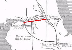
WThe Stanegate was an important Roman road built in what is now northern England. It linked two forts that guarded important river crossings: Corstopitum (Corbridge) on the River Tyne in the east, and situated on Dere Street, and Luguvalium (Carlisle) on the River Eden in the west. The Stanegate ran through the natural gap formed by the valleys of the River Tyne in Northumberland and the River Irthing in Cumbria. It predated Hadrian's Wall by several decades; the Wall would later follow a similar route, slightly to the north.
 W
WThe Sycamore Gap Tree or Robin Hood Tree is a sycamore tree standing next to Hadrian's Wall near Crag Lough in Northumberland, England. It is located in a dramatic dip in the landscape and is a popular photographic subject, described as one of the most photographed trees in the country. It derives its alternative name from featuring in a prominent scene in the 1991 film Robin Hood: Prince of Thieves. The tree won the 2016 England Tree of the Year award.
 W
WA turret was a small watch tower, incorporated into the curtain wall of Hadrian's Wall. The turrets were normally spaced at intervals of one third of a Roman mile between Milecastles, giving two Turrets between each Milecastle.
 W
WThe Vallum is a huge earthwork associated with Hadrian's Wall in England. Unique on any Roman frontier, it runs practically from coast to coast to the south of the wall.
 W
WThe Vindolanda tablets were, at the time of their discovery, the oldest surviving handwritten documents in Britain. They are a rich source of information about life on the northern frontier of Roman Britain. Written on fragments of thin, post-card sized wooden leaf-tablets with carbon-based ink, the tablets date to the 1st and 2nd centuries AD. Although similar records on papyrus were known from elsewhere in the Roman Empire, wooden tablets with ink text had not been recovered until 1973, when archaeologist Robin Birley, his attention being drawn by student excavator Keith Liddell, discovered some at the site of Vindolanda, a Roman fort in northern England.