 W
WFor administrative purposes British India was subdivided into the following units:
WThe Provinces of India, earlier Presidencies of British India and still earlier, Presidency towns, were the administrative divisions of British governance in the Indian subcontinent. Collectively, they have been called British India. In one form or another, they existed between 1612 and 1947, conventionally divided into three historical periods:Between 1612 and 1757 the East India Company set up "factories" in several locations, mostly in coastal India, with the consent of the Mughal emperors, Maratha empire or local rulers. Its rivals were the merchant trading companies of Portugal, Denmark, the Netherlands, and France. By the mid-18th century three Presidency towns: Madras, Bombay and Calcutta, had grown in size. During the period of Company rule in India, 1757–1858, the Company gradually acquired sovereignty over large parts of India, now called "Presidencies". However, it also increasingly came under British government oversight, in effect sharing sovereignty with the Crown. At the same time, it gradually lost its mercantile privileges. Following the Indian Rebellion of 1857 the company's remaining powers were transferred to the Crown. Under the British Raj (1858–1947), administrative boundaries were extended to include a few other British-administered regions, such as Upper Burma. Increasingly, however, the unwieldy presidencies were broken up into "Provinces".
WThe Divisions of British India were administrative units of the Government of the British Raj or Indian Empire.
WAn agency of British India was an internally autonomous or semi-autonomous unit of British India whose external affairs were governed by an agent designated by the Viceroy of India.
 W
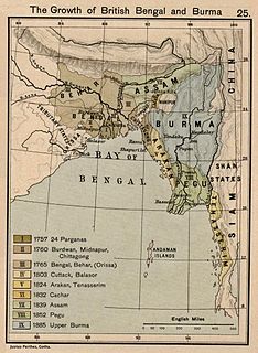
WColonial Assam (1826–1947) refers to the period of History of Assam between the signing of the Treaty of Yandabo and Independence of India when Assam was under the British colonial rule. The political institutions and social relations that were established or severed during this period continue to have a direct effect on contemporary events. The legislature and political alignments that evolved by the end of the British rule continued in the post Independence period. The immigration of farmers from East Bengal and tea plantation workers from Central India continue to affect contemporary politics, most notably that which led to the Assam Movement and its aftermath.
 W
WBengal is a geopolitical, cultural and historical region in South Asia, specifically in the eastern part of the Indian subcontinent at the apex of the Bay of Bengal, predominantly covering present-day Bangladesh and the Indian state of West Bengal. Geographically, it is made up by the Ganges-Brahmaputra delta system, the largest such formation in the world, along with mountains in its north bordering the Himalayan states of Nepal and Bhutan, and east bordering Myanmar.
 W
WThe Bohmong Circle is one of three hereditary chiefdoms in the Chittagong Hill Tracts of modern-day Bangladesh. The jurisdiction of the Bohmong Circle encompasses parts of Bandarban District. The chiefdom's members are of Marma descent and are known as ragraisa. Most inhabitants of the Mong Circle settled in the south during a migration wave from the Kingdom of Mrauk U between the 16th and 18th centuries, while inhabitants of the other Marma chiefdom, the Mong Circle, settled in the northwest and are known as phalansa (ဖလံသား).
 W
WThe present-day state of Assam and its predecessor Undivided Assam was colonized by the East India Company and the British Raj over a period of 150 years—beginning with the Goalpara region in 1765 to drawing of the McMahon Line in 1913-1914 when the British consolidated its rule over the present-day Arunachal Pradesh.
 W
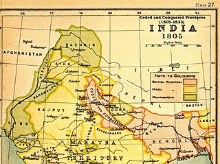
WThe Ceded and Conquered Provinces constituted a region in northern India that was ruled by the British East India Company from 1805 to 1834; it corresponded approximately—in present-day India—to all regions in Uttar Pradesh state with the exception of the Lucknow and Faizabad divisions of Awadh; in addition, it included the Delhi territory and, after 1816, the Kumaun division and a large part of the Garhwal division of present-day Uttarakhand state. In 1836, the region became the North-Western Provinces, and in 1904, the Agra Province within the United Provinces of Agra and Oudh.
 W
WThe Central Provinces was a province of British India. It comprised British conquests from the Mughals and Marathas in central India, and covered parts of present-day Madhya Pradesh, Chhattisgarh and Maharashtra states. Its capital was Nagpur. It became the Central Provinces and Berar in 1903.
WThe Central Provinces and Berar was a province of British India and later the Dominion of India which existed from 1903 to 1950. It was formed by the merger of the Central Provinces with the province of Berar, which was territory leased by the British from the Hyderabad State. Through an agreement signed on 5 November 1902, 6th Nizam Mahbub Ali Khan, Asaf Jah VI leased Berar permanently to the British for an annual payment of 25 lakhs Rupees. Lord Curzon decided to merge Berar with the Central Provinces, and this was proclaimed on 17 September 1903.
 W
WThe Chakma Circle, also known as the Chakma Raj, is one of three hereditary chiefdoms in the Chittagong Hill Tracts of modern-day Bangladesh. The Chakma Circle encompasses parts of Rangamati Hill District and Dighinala and Rajasthali Upazilas in neighbouring Khagrachari District and Bandarban District respectively. The chiefdom's members are of Chakma descent.
 W
WBefore the Partition of India in 1947, about 584 princely states, also called "native states", existed in India, which were not fully and formally part of British India, the parts of the Indian subcontinent which had not been conquered or annexed by the British but under indirect rule, subject to subsidiary alliances.
WThe Mong Circle is one of three hereditary chiefdoms in the Chittagong Hill Tracts of modern-day Bangladesh. The jurisdiction of the Mong Circle encompasses parts of Khagrachhari District. The chiefdom's members are of Marma descent and are known as phalansa. Most inhabitants of the Mong Circle settled in the northwest during a migration wave from the Kingdom of Mrauk U between the 16th and 18th centuries, while inhabitants of the other Marma chiefdom, the Bohmong Circle settled in the south and are known as ragraisa.
WThe North-Western Provinces was an administrative region in British India. The North-Western Provinces were established in 1836, through merging the administrative divisions of the Ceded and Conquered Provinces. In 1858, the nawab-ruled kingdom of Oudh was annexed and merged with the North-Western Provinces to form the renamed North-Western Provinces and Oudh. In 1902, this province was reorganized to form the United Provinces of Agra and Oudh. Allahabad served as its capital from 1858, when it also became the capital of India for a day.
WThe Northern Circars was a division of British India's Madras Presidency. It consisted of a narrow slip of territory lying along the western side of the Bay of Bengal from 15° 40′ to 20° 17′ north latitude, in the present-day Indian states of Andhra Pradesh and Odisha.
WBihar and Orissa was a province of British India, which included the present-day Indian states of Bihar, Jharkhand, and Odisha. The territories were conquered by the British in the 18th and 19th centuries, and were governed by the then Indian Civil Service of the Bengal Presidency, the largest administrative subdivision in British India.
 W
WThe Presidency of Coromandel and Bengal Settlements was an administrative division of British India, established by the East India Company on 17 July 1682.
WThe Saugor and Nerbudda Territories, was a region of British India, located in the central part of present-day Madhya Pradesh state in central India. It included the present-day districts of Sagar (Saugor), Damoh, Jabalpur, and Narsinghpur.
 W
WPenang is a Malaysian state located on the northwest coast of Peninsular Malaysia, by the Malacca Strait. It has two parts: Penang Island, where the capital city, George Town, is located, and Seberang Perai on the Malay Peninsula. They are connected by Malaysia's two longest road bridges, the Penang Bridge and the Sultan Abdul Halim Muadzam Shah Bridge; the latter is also, as of May 2019, the longest oversea bridge in Southeast Asia. The second smallest Malaysian state by land mass, Penang is bordered by Kedah to the north and the east, and Perak to the south.
 W
WThe Trucial States, also known as Trucial Coast, and the Trucial Sheikhdoms, was the name the British government gave to a group of tribal confederations in southeastern Arabia whose leaders had signed protective treaties, or truces, with the United Kingdom between 1820 and 1892.
 W
WTulsipur State was a small kingdom in the Awadh region of India that became the United Provinces of Agra and Oudh under the British Raj. Tulsipur also extended north beyond Dundwa Range of the Siwaliks to include the Dang and Deukhuri Valleys later part of the Kingdom of Nepal. It was one of the areas traditionally inhabited by the Tharu people.
 W
WThe United Provinces of Agra and Oudh was a province of India under the British Raj, which existed from 1902 to 1947; the official name was shortened by the Government of India Act 1935 to United Provinces (UP), by which the province had been commonly known, and by which name it was also a province of independent India until 1950.