 W
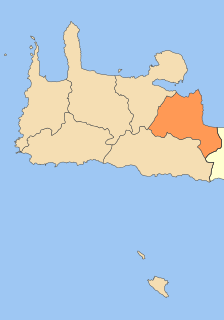
WAgios Nikolaos, Hagios Nikolaos or Aghios Nikolaos is a coastal town on the Greek island of Crete, lying east of the island's capital Heraklion, north of the town of Ierapetra and west of the town of Sitia.
 W
WAgios Vasileios is a village and a municipality in Rethymno regional unit, Crete, Greece. The seat of the municipality is the village Spili. The municipality has an area of 359.171 km2 (138.677 sq mi).
 W
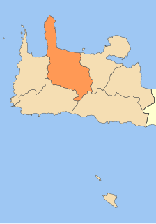
WAmari is a village and a municipality in Rethymno regional unit, Crete, Greece. The seat of the municipality is the village Agia Foteini. The municipal unit has an area of 277.285 km2 (107.060 sq mi). One of the major geographic features of Amari is the Amari Valley, a landform of high elevation known for olive cultivation. It is thought that Monastiraki was developed by Phaistos inhabitants founding a satellite center as they pushed out into the Amari Valley.
WAnogeia (Ανώγεια) is a municipality in the Rethymno regional unit, Crete, Greece. The municipality has an area of 102.632 km2 (39.626 sq mi). Population 2,379 (2011).
 W
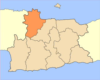
WApokoronas is a municipality and a former province (επαρχία) in the Chania regional unit, north-west Crete, Greece. It is situated on the north coast of Crete, to the east of Chania itself. The seat of the municipality is the village Vryses. The municipality has an area of 315.478 km2 (121.807 sq mi).
 W
WArchanes–Asterousia is a municipality in Heraklion regional unit, Crete, Greece. The seat of the municipality is the village Peza. The municipality has an area of 337.137 km2.
 W
WChania is a city in Greece and the capital of the Chania regional unit. It lies along the north west coast of the island Crete, about 70 km (43 mi) west of Rethymno and 145 km (90 mi) west of Heraklion.
 W
WElafonisi is an island located close to the southwestern corner of the Mediterranean island of Crete, of which it is administratively a part, in the regional unit of Chania. When the weather is fine it is possible to walk to the island through the shallow water. The island is a protected nature reserve. It is known for its pink sand beaches, created by tidal and wave-induced deposits of pigmented microorganisms living in a symbiotic relationship with native seaweed.
 W
WFaistos is a municipality in Heraklion regional unit, Crete, Greece. The seat of the municipality is the village Moires. It is named after the ancient city Phaistos, located in the municipality. The municipality has an area of 410.810 km2 (158.615 sq mi).
 W
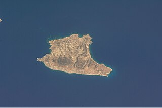
WGavdos is the southernmost Greek island, located to the south of its much larger neighbour, Crete, of which it is administratively a part, in the regional unit of Chania. It forms a community with surrounding islets and was part of the former Selino Province. The island is situated at the southern tip of Greece; it is the southernmost point of Europe.
 W
WGortyn, Gortys or Gortyna is a municipality, and an archaeological site, on the Mediterranean island of Crete 45 km (28 mi) away from the island's capital, Heraklion. The seat of the municipality is the village Agioi Deka. Gortyn was the Roman capital of Creta et Cyrenaica. The area was first inhabited around 7000 BC.
 W
WHeraklion or Iraklion is the largest city and the administrative capital of the island of Crete and capital of Heraklion regional unit. It is the fourth largest city in Greece with a population of 211,370 according to the 2011 census. The population of the municipality was 173,993.
 W
WHersonissos, also transliterated as Chersonissos and Hersónisos, is a town and a local government unit in the north of Crete, bordering the Mediterranean / Aegean Sea. The town is about 25 kilometers east of Heraklion and west of Agios Nikolaos. What is usually called Hersonissos is in fact its peninsula and harbour. It is part of the Heraklion regional unit. It is situated 25 km from the Heraklion airport and 27 km from the Heraklion port. The seat of the local government unit is the village of Gournes.
 W
WIerapetra is a Greek town and municipality located on the southeast coast of Crete.
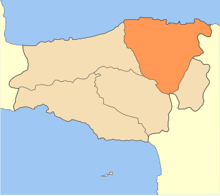
WKantanos-Selino is a municipality in Chania regional unit, Crete, Greece. It is numbered 4 on the map of the Chania region. The seat of the municipality is the village of Palaiochora. The municipality has an area of 376.254 km2 (145.272 sq mi). A significant number of fresco's painted by Ioannis Pagomenos are located in Selino.
 W
WKissamos is a town and a municipality in the west of the island of Crete, Greece. It is part of the Chania regional unit and of the former Kissamos Province which covers the northwest corner of the island. The town of Kissamos is also known as Kastelli Kissamou and often known simply as Kastelli after the Venetian castle that was there. It is now a port and fishing harbour, with a regular ferry from the Peloponnese via Kythira. A town museum is located in the old Venetian governor's palace and there have been important archaeological finds in the town, including fine mosaics, dating from the Roman city of Kisamos. The head town of the municipality is Kastelli-Kissamos itself.
 W
WThe Lasithi Plateau, sometimes spelt Lassithi Plateau is a high endorheic plateau, located in the Lasithi regional unit in eastern Crete, Greece. Since the 1997 Kapodistrias reform, it is a municipality whose seat is Tzermiado and the second biggest village is Agios Georgios. The municipality has an area of 129,9 km2.
 W
WMalevizi is a municipality in Heraklion regional unit, Crete, Greece. The seat of the municipality is the town of Gazi. The municipality has an area of 291.907 km2 (112.706 sq mi).
 W
WMinoa Pediada is a municipality in Heraklion regional unit, Crete, Greece. The seat of the municipality is the village Evangelismos. The municipality has an area of 398.206 km2 (153.748 sq mi).
 W
WMylopotamos is a municipality in Rethymno regional unit, on Crete, southern Greece. The seat of the municipality is the village Perama. The municipal unit has an area of 360.703 km2 (139.268 sq mi).
 W
WPlatanias is a village and municipality on the Greek island of Crete. It is located about 10 km (6.2 mi) west from the city of Chania and east of Kissamos, on Chania Bay. The seat of the municipality is the village Gerani. Platanias is a popular tourism village with beaches, several hotels, restaurants, bars, nightclubs and souvenir shops. The area is especially popular with Scandinavian tourists with the season running from April to October. Not far from the coast is the island of Agioi Theodoroi.
 W
WThe Municipality of Rethymno is a municipality in the Rethymno of the region of Crete established by Kallikratis reform. It consists of the unification of the pre-existing municipalities Arkadi, Lappa, Rethymno and Nikiforos Fokas of Rethymno Prefecture. The extent of the new municipality is 396.256 km2 (152.995 sq mi), and it had a population of 55,525 inhabitants at the 2011 census. The seat of the new municipality is the town Rethymno.
 W
WSfakiá is a mountainous area in the southwestern part of the island of Crete, in the Chania regional unit. It is considered to be one of the few places in Greece that have never been fully occupied by foreign powers. With a 2011 census population of 1,889 inhabitants living on a land area of 467.589 km2 (180.537 sq mi), Sfakia is one of the largest and least densely populated municipalities on the island of Crete. The etymology of its name is disputed. According to the prevailing theory, it relates to its rugged terrain, deriving from the ancient Greek word σφαξ, meaning land chasm or gorge.
 W
WSitia is a port town and a municipality in Lasithi, Crete, Greece. The town has 9,912 inhabitants (2011) and the municipality has 18,318 (2011). It lies east of Agios Nikolaos and northeast of Ierapetra. Sitia port is on the Sea of Crete, part of the Aegean Sea and is one of the economic centers of the Lasithi region. European route E75, which ends in Vardø, starts in Sitia. Sitia is served by the Sitia Public Airport. Sitia has not experienced the effects of mass tourism even though there is a long beach along the road leading to Vai and several places of historical interest.
 W
WViannos is a municipality in the Heraklion regional unit, Crete, Greece. The municipality has an area of 221.539 km2 (85.537 sq mi). Population 5,563 (2011). The seat of the municipality is in Ano Viannos.