 W
W22 Gia Long Street, now 22 Lý Tự Trọng Street, is an apartment building in Ho Chi Minh City, the largest city in Vietnam. In 1975, photojournalist Hubert van Es, working for UPI, captured an iconic photo of U.S government employees evacuating the city by helicopter during the Fall of Saigon, the last major battle of the Vietnam War. The evacuation was code named Operation Frequent Wind.
 W
WThe Ban Karai Pass is a mountain pass in the Annamite Range between northern Vietnam and Laos, located approximately 60 km southwest of Đồng Hới and 115 km northwest of Quảng Trị, Vietnam. The pass is 418 m above sea level and connects National Road 565 in Vietnam to Route 912 in Khammouane Province in Laos.
 W
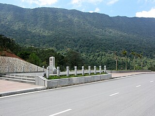
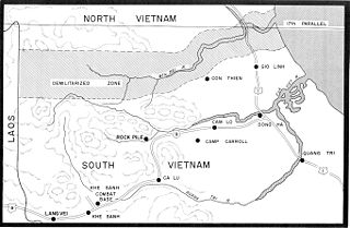
WThe Bến Hải River is a river in central Vietnam which became an important landmark in the partition of the country into a northern and a southern zone along the 17th parallel by the Geneva Accords of 1954 then ended in 1976. The demilitarized zone (DMZ) separating the two parts extended about 5 kilometers (3.1 mi) from either side of the river.
 W
WThe Bình An Cemetery is a cemetery in Dĩ An, Bình Dương Province, Vietnam. It was an Army of the Republic of Vietnam (ARVN) military cemetery.
 W
WChí Hòa Prison is a functioning Vietnamese prison located in Ho Chi Minh City, Vietnam. The prison is an octagonal building on a 7-hectare site consisting of detention rooms, jail cells, prison walls, watchtowers, facilities and prisoner's farmlands. The prison is one of 12 national prisons in Vietnam. Originally built by the French Indochina colonial government in 1943 to replace the Saigon Grand Prison, the prison was extensively used by all succeeding governments of Vietnam. Due to its complex and effective architecture, the prison is considered one of the highest security prisons in Vietnam as there were only two successful prison breaks in its history.
 W
WCôn Đảo Prison, also Côn Sơn Prison, is a prison on Côn Sơn Island the largest island of the Côn Đảo archipelago in southern Vietnam (today it is in Bà Rịa–Vũng Tàu Province. The prison was built in 1861 by the French colonists to jail those considered especially dangerous to the colonial government. Many of the high-ranking leaders of Vietnam were detained here. It is ranked a special historical relic of national importance by the government of Vietnam. The most famous site in this prison are the "tiger cages". The French tiger cages cover an area of 5.475 m2, within which each cell occupies 1.408 m2, solariums occupy 1.873 m2, and other spaces occupy 2.194 m2. The prison includes 120 cells. The prison was closed after the end of the Vietnam War and opened for visitors soon after.
 W
WCôn Sơn, also known as Côn Lôn,(Khmer: កោះត្រលាច) is the largest island of the Côn Đảo archipelago, off the coast of southern Vietnam.
 W
WDixie Station was a geographic position during the Vietnam War in the South China Sea off the Mekong Delta from which United States Navy aircraft carriers launched strikes providing close air support for American and Army of the Republic of Vietnam (ARVN) ground troops in South Vietnam. It was located about 130 km due southeast of Cam Ranh Bay, at 11° N and 110° E in 600 m (2000 ft) of water.
 W
WĐồng Lộc Junction was a strategic road T-junction at the beginning of the Ho Chi Minh trail which was extensively bombed by American forces during the Vietnam War. Although it is often referred to as a "crossroads" in English sources, a crossroads is ngã tư (4-junction), whereas a T-junction is ngã ba (3-junction).
 W
WDong Re Lao Mountain is located at 16.3038°N 107.2479°E in the A Shau Valley, Vietnam, near the Laotian border. It is densely forested and rises to 4,879 feet (1,487 m), just north of A Luoi, a former French airfield.
 W
WThe Ho Chi Minh Trail, also called Annamite Range Trail was a logistical network of roads and trails that ran from the Democratic Republic of Vietnam to the Republic of Vietnam through the kingdoms of Laos and Cambodia. The system provided support, in the form of manpower and materiel, to the National Front for the Liberation of South Vietnam and the People's Army of Vietnam (PAVN), or North Vietnamese Army (NVA), during the Vietnam War.
 W
WLeatherneck Square was an area just south of the Vietnamese Demilitarized Zone that separated North Vietnam and South Vietnam.
 W
WThe Mụ Giạ Pass is a mountain pass in the Annamite Range between northern Vietnam and Laos, located 90 km northwest of Đồng Hới, Vietnam. The pass is 418 m above sea level and connects National Road 15 from Tân Ấp in Vietnam to Route 12 in Khammouane Province in Laos.
 W
WMuang Soui is a small town in Xiangkhouang Province in northeastern Laos. It is located along Route 7, northwest of Phonsavan.
 W
WNational Route 9 runs across Vietnam roughly in line with the 17th Parallel. The route includes two segments. The segment called National Route 9A begins at Đông Hà and ends at Lao Bảo on the Vietnam-Laos border and is entirely within Quảng Trị Province. The 8 km-long segment called National Route 9B begins at Dong Ha and runs eastward to Cửa Việt Port.
 W
WNational Route 19 runs across Vietnam roughly in line with the 14th parallel north. The route includes two segments: National Route 19 begins at Qui Nhơn and ends just short of the Vietnam-Cambodia border, while National Route 19B begins on the Qui Nhơn peninsula and joins Route 1 east of Phu Cat Airport.
 W
WPhu Quoc Prison is a prison in Phú Quốc, southern Vietnam (today it is in Kiên Giang Province. The prison was built in 1949–1950 by French colonialists as a place to detain political dissidents. During the Vietnam War, it was used for detention of captured Viet Cong and North Vietnamese soldiers. Many of the high ranking leaders of Vietnam were detained here. It is ranked a special historical relic of national significance by the government of Vietnam. The prison covers an area of 40,000 square metres. The prison was closed after the country united, but is currently open for visitors.
WPIRAZ is a United States Navy acronym for Positive Identification Radar Advisory Zone. The zone is defined by the air search radar coverage of a ship patrolling a designated PIRAZ station. The concept was similar to radar picket stations established in World War II. The PIRAZ ship requires a Naval Tactical Data System radio-linked computer installation to effectively identify and track all aircraft anticipated to enter the airspace of the zone during combat.
 W
WThe Sơn Mỹ Memorial is a memorial to victims of the My Lai Massacre in Son My, Vietnam. It is located in the village of Tịnh Khê, Sơn Tịnh District, Quảng Ngãi Province. U.S. soldiers killed at least 504 Vietnamese in this area on 16 March 1968. The memorial was built in 1978. At the time of the massacre, Sơn Mỹ was a village that included Mỹ Lai and several other hamlets. Because Mỹ Lai was not the only hamlet involved, the Vietnamese media refers to the event as the "Sơn Mỹ massacre."
 W
WThe Sơn Tây prison camp was a POW camp operated by North Vietnam near Sơn Tây and approximately 23 miles (37 km) west of Hanoi in the late 1960s through late 1970 and again in 1975. About 65 US prisoners of war were held there during the middle of the Vietnam War. It was later used to house foreigners captured in South Vietnam during the 1975 Spring Offensive.
 W
WStreet Without Joy or La Rue Sans Joie was the name given by troops of the French Far East Expeditionary Corps to the stretch of Route 1 from Huế to Quảng Trị during the First Indochina War.
 W
WThud Ridge was the nickname given by United States Air Force F-105 Thunderchief pilots during the Vietnam War to the Tam Dao range a 24 km, 5000 ft high ridge that ran parallel to the Red River approximately 32 km northwest of Hanoi, which was both a waypoint during air attacks and a terrain masking feature for ingressing fighters in the vicinity of Hanoi, North Vietnam.
 W
WU Minh Thượng National Park or National Park of Upper U Minh is a national park in the province of Kiên Giang, Vietnam.
 W
WThe Vietnamese Demilitarized Zone was a demilitarized zone established as a dividing line between North and South Vietnam from July 1954 to 1976 as a result of the First Indochina War. During the Vietnam War (1955-1975) it became important as the battleground demarcation separating North from South Vietnamese territories. The zone ceased to exist with the reunification of Vietnam on 2 July 1976, though the area remains dangerous due to the numerous undetonated explosives it contains.
 W
WVinh Moc is a tunnel complex in Quảng Trị, Vietnam. During the Vietnam War it was strategically located on the border of North Vietnam and South Vietnam. The tunnels were built to shelter people from the intense bombing of Son Trung and Son Ha communes in Vinh Linh county of Quảng Trị Province in the Vietnamese Demilitarized Zone.
WYankee Station was a fixed coordinate off the coast of Vietnam where U.S. Navy aircraft carriers and support ships loitered in open waters over a nine-year period during the Vietnam War. The location was used primarily by aircraft carriers of Task Force 77 to launch strikes over North Vietnam. While the coordinate's official designation was "Point Yankee", it was universally referred to as Yankee Station. Carriers conducting air operations at Yankee Station were said to be "on the line" and statistical summaries were based on days on the line. Yankee Station was initially located at 16° 00′ N, 110° 00′ E, however with a massive increase in operations over North Vietnam in 1966 the station was moved about 145 miles (230 km) northwest to 17° 30′ N, 108° 30′ E, placing it about 90 miles (145 km) from the North Vietnamese shore.