 W
WThe geography of Egypt relates to two regions: North Africa and Southwest Asia.
 W
WAbbassia is a neighbourhood in Cairo, Egypt. The Saint Mark's Coptic Orthodox Cathedral, Cairo is located in Abbassia. The medical faculty of Ain Shams University and its affiliate hospital units are located in Abbassia. The Abbassia metro station is located here, as well.
 W
WBashmur was a region in the Nile Delta in Egypt. In the early Middle Ages, it was inhabited by Christian Copts and was the scene of a series of revolts against Arab rule in the 8th and 9th centuries.
 W
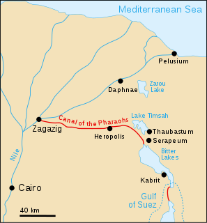
WThe Canal of the Pharaohs, also called the Ancient Suez Canal or Necho's Canal, is the forerunner of the Suez Canal, constructed in ancient times and kept in use, with intermissions, until being closed for good in 767 AD for strategic reasons during a rebellion. It followed a different course from its modern counterpart, by linking the Nile to the Red Sea via the Wadi Tumilat. Work began under the pharaohs. According to Darius the Great's Suez Inscriptions and Herodotus, the first opening of the canal was under Persian king Darius the Great, but later ancient authors like Aristotle, Strabo, and Pliny the Elder claim that he failed to complete the work. Another possibility is that it was finished in the Ptolemaic period under Ptolemy II, when engineers solved the problem of overcoming the difference in height through canal locks.
 W
WEgypt essentially has a hot desert climate. The climate is generally extremely dry all over the country except on the northern Mediterranean coast which receives rainfall in winter. In addition to rarity of rain, extreme heat during summer months is also a general climate feature of Egypt although daytime temperatures are more moderated along the northern coast.
 W
WEl Gorah is a locale in northeastern Sinai, in Egypt, approximately 16 kilometers from the Israeli border and 37 km southeast of El Arish. The area is sparsely populated by nomads and by farmers who tend small orchards.
 W
WThe Fraser Tombs are a necropolis located 10 km (6.2 mi) northeast of Al Minya, Upper Egypt. They sit around 2 km (1.2 mi) south of Tihna el-Gebel village, which was an ancient limestone quarry.
 W
WThe Gaza Strip smuggling tunnels are smuggling tunnels that had been dug under the Philadelphi Corridor along the Egypt-Gaza border. They were dug to combat the blockade of the Gaza Strip to smuggle in fuel, food, weapons and other goods into the Gaza Strip. After the Egypt–Israel Peace Treaty of 1979, the town of Rafah, in the southern Gaza Strip, was split by this Corridor. One part is located in the southern part of Gaza, and the smaller part of the town is in Egypt. After Israel withdrew from Gaza in 2005, the Philadelphi Corridor was placed under the control of the Palestine Authority until 2007, when Hamas seized power in 2007, and Egypt and Israel closed borders with the Gaza Strip.
 W
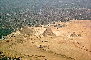
WThe Giza Plateau is a plateau in Giza, on the outskirts of Cairo, Egypt, site of the Fourth Dynasty Giza Necropolis, which includes the Great Pyramids of Khufu, Khafre and Menkaure, the Sphinx, several cemeteries, a workers' village and an industrial complex.
 W
WHu is the modern name of an Egyptian town on the Nile, which in more ancient times was the capital of the 7th Nome of Upper Egypt.
 W
WItbāy or ʿAtbāy is a region of southeastern Egypt and northeastern Sudan. It is characterised by a chain of mountains, the Red Sea Hills, running north–south and parallel with the Red Sea. The hills separate the narrow coastal plain from the Eastern Desert.
 W
WKassassin is a village of Lower Egypt 22 miles (35 km) by rail west of Ismailia, a major city on the Suez Canal.
 W
WThe Mokattam, also known as the Mukattam Mountain or Hills, is the name of a range of hills and a suburb in them, located in southeastern Cairo, Egypt.
 W
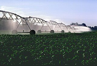
WThe New Valley Project or Toshka Project consists of building a system of canals to carry water from Lake Nasser to irrigate part of the sandy wastes of the Western Desert of Egypt, which is part of the Sahara Desert. In 1997, the Egyptian government decided to develop a new valley where agricultural and industrial communities would develop. It has been an ambitious project which was meant to help Egypt cope with its rapidly growing population.
 W
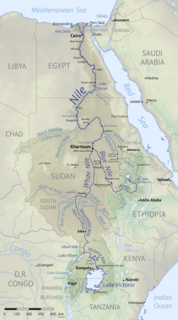
WThe Nile Basin is the part of Africa drained by the Nile River and its tributaries.
 W
WThe Northern Coast of Egypt extends for about 1,050 km (650 mi) along the Mediterranean Sea, it covers entirely the northern territory of Egypt. It is one of the longest Mediterranean coastlines in North Africa.
 W
WRuweisat Ridge is a geographical feature in the Western Egyptian desert, midway between the Mediterranean Sea and the Qattara Depression. During World War II was a prominent part of the defence line in the First and Second Battle of El Alamein. During the Second Battle of El Alamein, the 4th Indian Infantry Division was given the task of defending the feature.
 W
WSahl Hasheesh is a bay located on the Red Sea coast of Egypt, across from Sharm El Sheikh, approximately 18 km south of Hurghada International Airport.
 W
WSamannud is a city (markaz) located in Gharbia Governorate, Egypt. Known in classical antiquity as Sebennytos, Samannud is a historic city that has been inhabited since the Ancient Egyptian period. As of 2019, the population of the markaz of Samannud was estimated to be 410,388, with 83,417 people living in urban areas and 326,971 in rural areas.
 W
WSharq El Owainat is located in the New Valley Governorate of Egypt. It is in the south-west of the country, between the Nile and Libya.
WSidi Abdel Rahman is a village on the coast of the Mediterranean Sea in Egypt. It is most famous for its beach located 132 kilometres (82 mi) west of Alexandria and some 30 km (19 mi) west of Al Alamein. This desert and beach area is located some 190 km (120 mi) east of Mersa Matruh and is often a resting point on trips from Alexandria to the Siwa Oasis and to Matruh.
 W
WSidi Bishr is a neighborhood in the Montaza District of Alexandria, Egypt. Established as a summering site by the Egyptian middle class before the Revolution of 1952, it has since become one of the largest neighborhoods of the city.
 W
WThe Egyptian Geographic Society was established by a decree of Khedive Ismail Pasha on 19 May 1875. Its first president was the German botanist, traveller and ethnologist Georg August Schweinfurth. Founded as the Khedivial Society of Geography, its name was modified several times in order to reflect Egypt's changing political status. It acquired its current name following the Egyptian Revolution of 1952.
 W
WThe Suez Canal is an artificial sea-level waterway in Egypt, connecting the Mediterranean Sea to the Red Sea through the Isthmus of Suez and dividing Africa and Asia. The canal is part of the Silk Road that connects Europe with Asia.
 W
WThe Tibesti-Jebel Uweinat montane xeric woodlands is a deserts and xeric shrublands ecoregion in the eastern Sahara. The woodlands ecoregion occupies two separate highland regions, covering portions of northern Chad, southwestern Egypt, southern Libya, and northwestern Sudan.
 W
WVia Maris is one modern name for an ancient trade route, dating from the early Bronze Age, linking Egypt with the northern empires of Syria, Anatolia and Mesopotamia — along the Mediterranean coast of modern-day Egypt, Palestine, Israel, Iran, Iraq, Turkey and Syria. In Latin, Via Maris means "way of the sea", a translation of the Greek ὁδὸν θαλάσσης found in Isaiah 9:1 of the Septuagint. It is a historic road that runs in part along the Israeli Mediterranean coast. It was the most important route from Egypt to Syria which followed the coastal plain before crossing over into the plain of Jezreel and the Jordan valley.
 W
WWadi Feiran or Wadi Faran is Sinai's largest and widest wadi. It rises from the mountains around Saint Catherine's Monastery, at 2500 m above sea level. It is important because according to legend it is the site of Rephidim, where Moses struck a rock caused it to spring water, allowing his people the Hebrews to drink.