 W
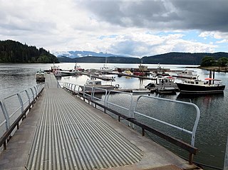
WAlliford Bay is a bay, and was the location of a town, on Moresby Island on Haida Gwaii. It is 15 kilometers west of Sandspit and is now a terminus for BC Ferries and North Pacific Seaplanes.
 W
WNaval Station Argentia is a former base of the United States Navy that operated from 1941 to 1994. It was established in the community of Argentia in what was then the Dominion of Newfoundland, which later became the tenth Canadian province, Newfoundland and Labrador.
 W
WThe Township of Ashfield–Colborne–Wawanosh is a municipality in Huron County, Ontario, Canada. It was formed as an amalgamation of the former Ashfield, Colborne and West Wawanosh townships in 2001, in an Ontario-wide local government restructuring imposed by the government of that time. The three former townships now comprise the wards of the amalgamated municipality. Mayor of Dungannon Robert Brindley Jr.
 W
WCap-de-la-Madeleine is a former city in Quebec, Canada at the confluence of the Saint-Maurice River and the St. Lawrence River. It was amalgamated into the City of Trois-Rivières in 2002. Population 33,022.
 W
WDavidson is a town in south central Saskatchewan, Canada. It is located 104 kilometres (65 mi) southeast of Saskatoon beside provincial highway 11, in the rural municipality of Arm River. It is located approximately halfway between Saskatoon and Regina, is a popular stopping-off with many restaurants and gas stations located adjacent to the highway.
WJarvis is a small community in Haldimand County, Ontario, Canada.
 W
WRCAF Station Fingal was a Second World War British Commonwealth Air Training Plan (BCATP) air station located near Fingal, Ontario, Canada. It was operated and administered by the Royal Canadian Air Force (RCAF).
 W
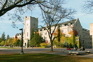
WRCAF Station Guelph was a Second World War British Commonwealth Air Training Plan (BCATP) station located in Guelph, Ontario on the campus of the Ontario Agricultural College (OAC), the Ontario Veterinary College (OVC), and the Macdonald Institute. The station is usually known as No. 4 Wireless School and was home to several schools as well as test facilities for air force kitchens.
 W
WRoyal Canadian Air Force Station Jarvis was a Second World War British Commonwealth Air Training Plan (BCATP) station located near Jarvis, Ontario. The station was home to No. 1 Bombing and Gunnery School and is usually known by that name. Bombing and Gunnery schools trained Air Gunners, Wireless Air Gunners, Air Observers, Air Bombers, and Navigator-Bomb Aimers. These airmen served as aircrew on bombers and maritime patrol aircraft.
 W
WRCAF Station Macdonald was a RCAF air training station located 16 km (10 mi) northwest of Portage la Prairie, Manitoba.
 W
WSaint-Jean Airport,, is located in the southwestern section of the city of Saint-Jean-sur-Richelieu, Quebec, Canada. The airport handles general aviation traffic and is also the main site of the annual International Balloon Festival of Saint-Jean-sur-Richelieu. Summer also sees a major increase in the number of movements due to the Royal Canadian Air Cadets glider center held at the airport.
 W
WSt. Thomas Municipal Airport,, located 3.5 nautical miles east of St. Thomas, Ontario, Canada is a small airport serving the general aviation needs of the area. The airport was established in 1941 as an air training base for the British Commonwealth Air Training Program. The base was operated by the Department of National Defence until the late 1940s as a relief field for No. 14 Service Flying Training School Aylmer, Ontario and No. 4 Bombing & Gunnery School Fingal, Ontario. It has a six runways, and four IFR approaches.
 W
WWindsor is a town of 5,300 people, part of the Le Val-Saint-François Regional County Municipality in the Estrie region of Quebec, Canada, of which it is the seat.
 W
WBell Island is an island located off the Avalon Peninsula of Newfoundland and Labrador, Canada in Conception Bay. Measuring 9.7 kilometres (6.0 mi) in length and 3.5 kilometres (2.2 mi) in width, it has an area of 34 square kilometres. The subsurface is composed of Ordovician sandstone and shale with red hematite. It was once the site of large iron ore mines.
 W
WThis article contains a List of Facilities of the British Commonwealth Air Training Plan (BCATP) in Canada. The BCATP was a major program for training Allied air crews during World War II that was administered by the Government of Canada, and commanded by the Royal Canadian Air Force with the assistance of a board of representatives from the United Kingdom, Australia, New Zealand and Canada.
 W
WCamp X was the unofficial name of the secret Special Training School No. 103, a Second World War British paramilitary installation for training covert agents in the methods required for success in clandestine operations. It was located on the northwestern shore of Lake Ontario between Whitby and Oshawa in Ontario, Canada. The area is known today as Intrepid Park, after the code name for Sir William Stephenson, Director of British Security Co-ordination (BSC), who established the program to create the training facility.
 W
WKaien Island is a Canadian island on the coast of British Columbia, just north of the mouth of the Skeena River and to the south of the Alaska Panhandle. The island has an area of about 45 square kilometres, is roughly oval, and about 11 kilometres (6.8 mi) long along its long axis. The island consists of a central mountain ridge, surrounded by coastal lowlands, the dominant central peak is Mount Hays reaching 708 metres (2,323 ft), with a secondary peak, Mount Olfield reaching 555 metres (1,821 ft) to the northeast.
 W
WCoal Harbour is a harbour and community on northern Vancouver Island, British Columbia, Canada located on the north side of Holberg Inlet in the Quatsino Sound region. It is named after a small and unsuccessful local coal mine that was founded in 1883. The village's most successful industry, however, was whaling. It was the last whaling station in British Columbia when it closed in 1967. The station utilized the original buildings of the RCAF.
 W
WDigby Island is a small island immediately west of Kaien Island, which is the location of the city of Prince Rupert, British Columbia. The island is home to the Prince Rupert Airport and the small community of Dodge Cove. The island is named for Henry A. Digby, an officer on HMS Malacca.
 W
WFort Amherst is a neighbourhood in St. John's, Newfoundland and Labrador. It is located at 47°33′48.96″N 52°40′49.60″W, on the southern side of the Narrows, the entrance to St. John's harbour. Apart from some family dwellings, Fort Amherst consists of a man-made harbour, a lighthouse and the remains of gun emplacements built during World War II to defend against German U-boats. Two QF 4.7-inch B Mark IV* guns remain in place, and can still be seen on their mountings.
 W
WFort Rodd Hill National Historic Site is a 19th-century coastal artillery fort on the Colwood, British Columbia side of Esquimalt Harbour,. The site is adjacent to Fisgard Lighthouse National Historic Site, the first lighthouse on the west coast of Canada. Both the fort and lighthouse are managed and presented to the public by Parks Canada.
WDigby Island is a small island immediately west of Kaien Island, which is the location of the city of Prince Rupert, British Columbia. The island is home to the Prince Rupert Airport and the small community of Dodge Cove. The island is named for Henry A. Digby, an officer on HMS Malacca.
 W
WThe Macaulay Point Battery is a historic gun emplacement in Victoria, British Columbia. A fort was built here between February 1894 and October 1897. The site is now a park.
WKaien Island is a Canadian island on the coast of British Columbia, just north of the mouth of the Skeena River and to the south of the Alaska Panhandle. The island has an area of about 45 square kilometres, is roughly oval, and about 11 kilometres (6.8 mi) long along its long axis. The island consists of a central mountain ridge, surrounded by coastal lowlands, the dominant central peak is Mount Hays reaching 708 metres (2,323 ft), with a secondary peak, Mount Olfield reaching 555 metres (1,821 ft) to the northeast.
 W
WSteveston, founded in the 1880s, is a neighbourhood of Richmond in Metro Vancouver. On the southwest tip of Lulu Island, the village is a historic port and salmon canning centre at the mouth of the South Arm of the Fraser River. The early 1900s style architecture attracts both the film and tourism industries.
 W
WThe Battery is a neighbourhood within the city of St. John's, Newfoundland and Labrador that sits on the entrance to the harbour, on the slopes of Signal Hill. It is sometimes described as an outport within the city of St. John's and is noted for its steep slopes, and colourful houses. The Battery has been the site, over the centuries, for gun emplacements (batteries), such as Fort Waldegrave, for the defence of St. John's Harbour, including during both World Wars.
 W
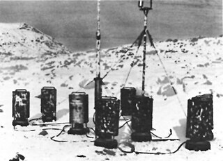
WWeather Station Kurt was an automatic weather station, erected by a German U-boat crew in northern Labrador, Dominion of Newfoundland in October 1943. Installing the equipment for the station was the only known armed German military operation on land in North America during the Second World War. After the war it was forgotten until its rediscovery in 1977.