 W
WFort Albany was a bastioned earthwork that the Union Army built in Arlington County in Virginia. The Army constructed the fort during May 1861 as part of its Civil War defenses of Washington.
 W
WThe Civil War Defenses of Washington were a group of Union Army fortifications that protected the federal capital city, Washington, D.C., from invasion by the Confederate States Army during the American Civil War. The sites of some of these fortifications are within a collection of National Park Service (NPS) properties that the National Register of Historic Places identifies as the Fort Circle. The sites of other such fortifications in the area have become parts of state, county or city parks or are located on privately owned properties. A trail connecting the sites is part of the Potomac Heritage Trail.
 W
WFort Clifton Archeological Site is a historic American Civil War fort archaeological site located at Fort Clifton Park, Colonial Heights, Virginia. The park is the site of Fort Clifton on the Appomattox River where five Union ships sailed on Confederate troops on June 11, 1864. The Confederate Battery, with cannon emplacements, remained in Confederate hands as the cannons drove the Union attackers away. The park has earthworks that criss-cross the property. Fort Clifton Park has hiking trails and Civil War campaign signage on site.
 W
WBuilt by Confederate Lieutenant Collier and Virginia militia with the aid of Federal prisoners, the Fort Collier redoubt guarded the north entrance of Winchester, Virginia on the east side of the Martinsburg Pike. During later Federal occupations, it was known as Battery No. 10. The fort was set on low ground, and generally offered little military advantage, except as a guard post for the pike. LtGen Jubal Early used it as part of his defensive works in the Third Battle of Winchester.
 W
WFort Corcoran was a wood-and-earthwork fortification constructed by the Union Army in northern Virginia as part of the defenses of Washington, D.C. during the American Civil War. Built in 1861, shortly after the occupation of Arlington, Virginia by Union forces, it protected the southern end of the Aqueduct Bridge and overlooked the Potomac River and Theodore Roosevelt Island, known as Mason's Island.
 W
WFort Darling was a Confederate military installation during the American Civil War located at Drewry's Bluff, a high point of 80–100 feet overlooking a bend in the James River south of Richmond in Chesterfield County, Virginia. It protected the Confederate capital of Richmond from Union naval attacks throughout most of the war.
 W
WThe Fort Early and Jubal Early Monument was started in the early 1900s, and consists of the remains of an American Civil War fort and monument located on a 1.29-acre (5,200 m2) site at Lynchburg, Virginia. Confederate forces under the command of Lt. Gen. Jubal Early constructed the roughly square earthen fort in June 1864 as part of the outer defenses of Lynchburg as the Union Army of West Virginia, under Maj. Gen. David Hunter, advanced from the north and west in an attempt to capture the city during the Battle of Lynchburg. It is the only section of the Lynchburg defenses still in existence.
 W
WFort Edward Johnson was a series of Confederate States of America (CSA) military breastworks constructed in April 1862 by the four-thousand member brigade known as the "Army of the Northwest". The Army of the Northwest was a remnant of the Confederate Army of the Northwest which had been disbanded in February 1862. The Army of the Northwest was commanded by Colonel Edward "Alleghany" Johnson and had been ordered to secure a major roadway through the Appalachian Mountains known as the Staunton and Parkersburg Turnpike. Johnson ordered the construction of fortifications and breastworks at a high point along the turnpike on top of Shenandoah Mountain, which is in the U.S. state of Virginia, 26 miles (42 km) west of Staunton.
 W
WFort Ellsworth was a timber and earthwork fortification constructed west of Alexandria, Virginia, as part of the defenses of Washington, D.C. during the American Civil War. Built in the weeks following the Union defeat at Bull Run, Fort Ellsworth was situated on a hill north of Hunting Creek, and Cameron Run,. From its position on one of the highest points west of Alexandria, the fort overlooked the Orange and Alexandria Railroad, the Little River Turnpike, and the southern approaches to the city of Alexandria, the largest settlement in Union-occupied Northern Virginia.
 W
WFort Ethan Allen was an earthwork fortification that the Union Army built in 1861 on the property of Gilbert Vanderwerken in Alexandria County, Virginia, as part of the Civil War defenses of Washington. The remains of the fort are now within Arlington County's Fort Ethan Allen Park.
 W
WFreestone Point Confederate Battery is a historic American Civil War gun emplacement located at Leesylvania State Park, Woodbridge, Prince William County, Virginia. The battery has four individual gun emplacements, which are fairly simple in configuration. All are formed by a large, deep, rectangular depression with high earthen berms built up on the north and south side of each depression. Three of the batteries are located on the cliff about 90 feet above the Potomac River. For five months, from October 1861 to March 1862, the batteries contributed to the Confederate military's success in blockading the Potomac River.
 W
WBattery Garesche or Battery Garesché was a Union Army artillery battery built as part of the defenses of Washington, D.C. in the American Civil War at what is now Abingdon Street at South 30th Road in Fairlington, Arlington County, Virginia.
 W
WFort Gregg was a Confederate fort located near Petersburg, Virginia.
 W
WFort Harrison, later renamed Fort Burnham, was an important component of the Confederate defenses of Richmond during the American Civil War. Named after Lieutenant William Harrison, a Confederate engineer, it was the largest in the series of fortifications that extended from New Market Road to the James River that also included Forts Brady, Hoke, Johnson, Gregg, and Gilmer. These earthworks were designed to protect the strategically important Chaffin's Bluff on the James.
 W
WFort Lyon was a timber and earthwork fortification constructed south of Alexandria, Virginia as part of the defenses of Washington, D.C. during the American Civil War. Built in the weeks following the Union defeat at Bull Run, Fort Lyon was situated on Ballenger's Hill south of Hunting Creek, and Cameron Run, near Mount Eagle. From its position on one of the highest points south of Alexandria, the fort overlooked Telegraph Road, the Columbia Turnpike, the Orange and Alexandria Railroad, the Little River Turnpike, and the southern approaches to the city of Alexandria, the largest settlement in Union-occupied Northern Virginia.
 W
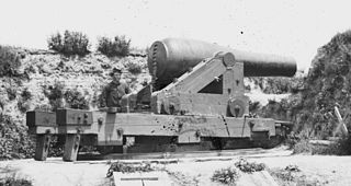
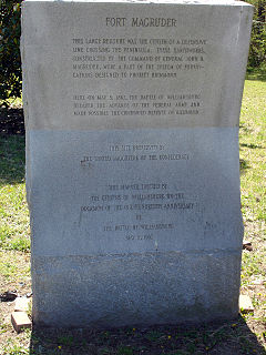
WFort Magruder was a 30-foot (9.1 m) high earthen fortification straddling the road between Yorktown and Williamsburg, Virginia, just outside the latter city during the American Civil War. At the center of the Williamsburg Line, it was also referred to as Redoubt Number 6.
 W
WFort Marcy Park is a public park located in unincorporated McLean, Virginia, in Fairfax County. It is administered by the National Park Service as part of the George Washington Memorial Parkway.
 W
WFort Monroe, preserved as the Fort Monroe National Monument, is a decommissioned military installation in Hampton, Virginia, at Old Point Comfort, the southern tip of the Virginia Peninsula, United States. Along with Fort Wool, Fort Monroe originally guarded the navigation channel between the Chesapeake Bay and Hampton Roads—the natural roadstead at the confluence of the Elizabeth, the Nansemond and the James rivers. Until disarmament in 1946, the areas protected by the fort were the entire Chesapeake Bay and Potomac River regions, including the water approaches to the cities of Washington, D.C. and Baltimore, Maryland, along with important shipyards and naval bases in the Hampton Roads area. Surrounded by a moat, the six-sided bastion fort is the largest fort by area ever built in the United States.
 W
WFort Myer is the previous name used for a U.S. Army post next to Arlington National Cemetery in Arlington County, Virginia, and across the Potomac River from Washington, D.C. Founded during the American Civil War as Fort Cass and Fort Whipple, the post merged in 2005 with the neighboring Marine Corps installation, Henderson Hall, and is today named Joint Base Myer–Henderson Hall.
 W
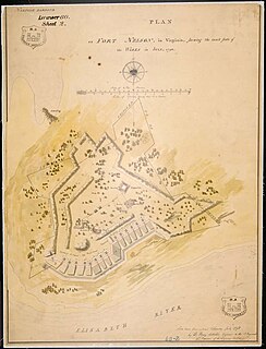
WFort Nelson was a fort located on Hospital Point in Portsmouth, Virginia, which is currently the site of the Portsmouth Naval Hospital. The fort was named for Thomas Nelson Jr., governor of Virginia in 1781. It and Fort Norfolk were built to guard the Elizabeth River, including the cities of Norfolk and Portsmouth and the Gosport Navy Yard. The fort was originally built by patriot forces with funding from the Virginia government in 1776 during the American Revolutionary War, but destroyed when the British occupied the area in 1779. A British map shows that they rebuilt the fort by 1781. Following the Revolution, the fort was again rebuilt in 1794 under the first system of US fortifications, was garrisoned in the War of 1812, but was demolished in 1827 to make room for the naval hospital. The fort was again rebuilt by Confederate forces in 1861, but the Confederates evacuated the area in May 1862 and the fort was eventually demolished.
 W
WFort Norfolk is a historic fort and national historic district located at Norfolk, Virginia. With the original buildings having been built between 1795 and 1809, the fort encloses 11 buildings: main gate, guardhouse, officers' quarters, powder magazine, and carpenter's shop. Fort Norfolk is the last remaining fortification of President George Washington's 18th century harbor defenses, later termed the first system of US fortifications. It has served as the district office for the U.S. Army Engineer District, Norfolk since 1923.
 W
WFort Pocahontas was an earthen fort on the north bank of the James River at Wilson's Wharf, in Charles City County, Virginia which served as a Union supply depot during the American Civil War. The fort was constructed by African-American soldiers of the United States Colored Troops under the command of Brig. Gen. Edward Augustus Wild.
 W
WFort Reynolds was a Union Army redoubt built as part of the defenses of Washington, D.C., in the American Civil War.
 W
WFort Richardson was a detached redoubt that the Union Army constructed in September 1861 as part of the Civil War defenses of Washington. The Army built the fort shortly after its rout at the First Battle of Bull Run (Manassas) in late July 1861. The Army named the fort after General Israel B. Richardson, whose division had been deployed to defend the City of Washington against attack by way of the Columbia Turnpike.
 W
WFort Runyon was a timber and earthwork fort constructed by the Union Army following the occupation of northern Virginia in the American Civil War in order to defend the southern approaches to the Long Bridge as part of the defenses of Washington, D.C. during that war. The Columbia Turnpike and Alexandria and Loudon Railroad ran through the pentagonal structure, which controlled access to Washington via the Long Bridge. With a perimeter of almost 1,500 yards (1,400 m), and due to its unusual shape it was approximately the same size, shape, and in almost the same location as the Pentagon, built 80 years later.
 W
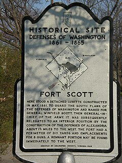
WFort Scott was a detached lunette constructed in May 1861 to guard the south flank of the defenses of Washington during the American Civil War. It was named for General Winfield Scott, who was then General-in-Chief of the Union Army. An historic marker and a small remnant of the fort are the only evidence of the site of the fort on the grounds of what is now Fort Scott Park in Arlington County, Virginia.
 W
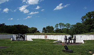
WFort Ward is a former Union Army installation now located in the city of Alexandria in the U.S. state of Virginia. It was the fifth largest fort built to defend Washington, D.C. in the American Civil War. It is currently well-preserved with 90-95% of its earthen walls intact.
 W
WFort Williams was a timber and earthwork fortification constructed in Alexandria, Virginia as part of the defenses of Washington, D.C. during the American Civil War.
WFort Woodbury was part of the Arlington Line, an extensive network of fortifications erected in present-day Arlington County, Virginia to protect Washington, D.C. from Confederate attack during the American Civil War. Construction began on the Arlington Line in May 1861, shortly after war broke out, and accelerated after the Union's defeat at the First Battle of Bull Run in July 1861.