 W
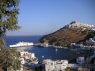
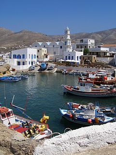
WAgathonísi is a small Greek island and municipality located at the northernmost point of the Dodecanese in Greece. It is surrounded by many smaller islands and is home to two villages, both inland; Megalo Chorio, and Mikro Chorio. Between them is the small settlement of Agios Georgios, which forms the island's only harbor and consists of a few hotels and restaurants. The island is also locally known as Gaidaro ("Donkey"), or by its ancient name Tragea.
 W
WAmorgos is the easternmost island of the Cyclades island group and the nearest island to the neighboring Dodecanese island group in Greece. Along with 16 neighboring islets, the largest of which is Nikouria Island, it comprises the municipality of Amorgos, which has a land area of 126.346 square kilometres and a population of 1,973.
 W
WAnafi, anciently, Anaphe, is a Greek island community in the Cyclades. In 2011, it had a population of 271. Its land area is 40.370 square kilometres. It lies east of the island of Thíra (Santorini). Anafi is part of the Thira regional unit.
 W
WAndros is the northernmost island of the Greek Cyclades archipelago, about 10 km (6 mi) southeast of Euboea, and about 3 km (2 mi) north of Tinos. It is nearly 40 km (25 mi) long, and its greatest breadth is 16 km (10 mi). It is for the most part mountainous, with many fruitful and well-watered valleys. The municipality, which includes the island Andros and several small, uninhabited islands, has an area of 380 km2 (146.719 sq mi). The largest towns are Andros (town), Gavrio, Batsi, and Ormos Korthiou.
 W
WAntiparos is a small island in the southern Aegean, at the heart of the Cyclades, which is less than one nautical mile (1.9 km) from Paros, the port to which it is connected with a local ferry. Saliagos island is the most ancient settlement in the Cyclades, and Despotiko, an uninhabited island in the southwest of Antiparos, is a place of great archaeological importance.
 W
WAstypalaia, is a Greek island with 1,334 residents. It belongs to the Dodecanese, an archipelago of twelve major islands in the southeastern Aegean Sea.
 W
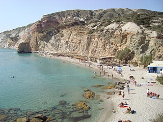
WFiriplaka or Firiplaka Beach is a beach situated at the southern side in Milos Island, Greece between the other beaches of Provatas (West) and Tsigrado (East). It is one of the most popular beach on the island. The beach is extensive with majestic towering volcanic cliffs, snow-grey fine sand and white pebbles and shallow turquoise waters. There are umbrellas and sunbeds and a bar hut. There is also a huge rock with a cave under it in the water near the shore and it was sculptured out from a volcanic a long time ago. The access to the beach is possible by your own vehicle, taxi, bus or even boat which goes around the island from the port of Adamas. The largest part of the road is asphalt, however the last part of it, is a gravel paved driveway.
 W
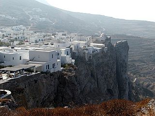
WFolegandros is a small Greek island in the Aegean Sea that, together with Sikinos, Ios, Anafi and Santorini, forms the southern part of the Cyclades. Its surface area is 32.216 square kilometres (12.439 sq mi) and it has 765 inhabitants. It has three small villages, Chora, Karavostasis, and Ano Meria, which are connected by a paved road. Folegandros is part of the Thira regional unit.
 W
WHalki is a Greek island and municipality in the Dodecanese archipelago in the Aegean Sea, some 9 km (6 mi) west of Rhodes. With an area of 28 km2 (11 sq mi), it is the smallest inhabited island of the Dodecanese. It is part of the Rhodes regional unit. It has a permanent population of 330, concentrated in the only village Emborio. The 2011 census showed a population of 478 inhabitants. The community is divided in two parts, Chorio Emporio.
 W
WIos, Io or Nio is a Greek island in the Cyclades group in the Aegean Sea. Ios is a hilly island with cliffs down to the sea on most sides, situated halfway between Naxos and Santorini. It is about 18 kilometres long and 10 kilometres wide, with an area of 109.024 square kilometres (42.094 sq mi). Population was 2,024 in 2011. Ios is part of the Thira regional unit.
 W
WKalymnos is a Greek island and municipality in the southeastern Aegean Sea. It belongs to the Dodecanese island chain, between the islands of Kos and Leros : the latter is linked to it through a series of islets. Kalymnos lies between two and five hours away by sea from Rhodes.
 W
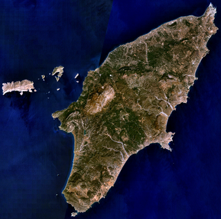
WKarpathos, also Carpathos, is the second largest of the Greek Dodecanese islands, in the southeastern Aegean Sea. Together with the neighboring smaller Saria Island it forms the municipality of Karpathos, which is part of the Karpathos regional unit. Because of its remote location, Karpathos has preserved many peculiarities of dress, customs and dialect, the last resembling those of Crete and Cyprus. Karpathos has also been called Carpathus in Latin and Scarpanto in Italian. The island lies within the subtropical zone, being at 35ºN latitude.
 W
WKasos, also Casos, is a Greek island municipality in the Dodecanese. It is the southernmost island in the Aegean Sea, and is part of the Karpathos regional unit. As of 2011, its population was 1,084.
 W
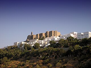
WKastellorizo or Castellorizo, officially Megisti, is a Greek island and municipality of the Dodecanese in the Eastern Mediterranean. It lies roughly 2 kilometres off the south coast of Turkey, about 570 km (354 mi) southeast of Athens and 125 km (78 mi) east of Rhodes, almost halfway between Rhodes and Antalya, and 280 km (170 mi) northwest of Cyprus. Kastellorizo is part of the Rhodes regional unit.
 W
WKea, also known as Tzia and in antiquity Keos, is a Greek island in the Cyclades archipelago in the Aegean Sea. Kea is part of the Kea-Kythnos regional unit.
 W
WKimolos is a Greek island in the Aegean Sea. It lies on the southwest of the island group of Cyclades, near the bigger island of Milos. Kimolos is the administrative center of the municipality of Kimolos, which also includes the uninhabited islands of Polyaigos, Agios Efstathios and Agios Georgios. The island has a land area of 36 square kilometres (13.900 sq mi), while the municipality's land area is 53.251 square kilometres (20.560 sq mi), and it reported a population of 910 inhabitants in the 2011 census.
WKos or Cos is a Greek island, part of the Dodecanese island chain in the southeastern Aegean Sea. Kos is the third largest island of the Dodecanese by area, after Rhodes and Karpathos; it has a population of 33,388, making it the second most populous of the Dodecanese, after Rhodes. The island measures 40 by 8 kilometres. Administratively, Kos constitutes a municipality within the Kos regional unit, which is part of the South Aegean region. The principal town of the island and seat of the municipality is Kos Town.
 W
WKythnos is a Greek island and municipality in the Western Cyclades between Kea and Serifos. It is 56 nautical miles (104 km) from the Athenian harbor of Piraeus. The municipality Kythnos is 100.187 km2 (38.68 sq mi) in area and has a coastline of about 100 km (62 mi). It has more than 70 beaches, many of which are still inaccessible by road. Of particular note is the crescent-shaped isthmus of fine sand at Kolona.
 W
WLeipsoi is an island south of Samos and to the north of Leros in Greece. It is well serviced with ferries passing between Patmos and Leros and on the main route for ferries from Piraeus. Leipsoi is a small group of islets at the northern part of the Dodecanese near to Patmos island and Leros. The larger Leipsi-Arkoi archipelago consists of some 37 islands and islets of which only three are larger than 1 square kilometre : Leipsoi, Arkoi and Agreloussa. Only Leipsoi, Arkoi and Marathos are inhabited. Leipsoi is a municipality, part of the Kalymnos regional unit, which is part of the South Aegean region. The municipality has an area of 17.350 square kilometres (6.699 sq mi). In ancient times, it contained a town named Lepsia.
 W
WLeros is a Greek island and municipality in the Dodecanese in the southern Aegean Sea. It lies 317 kilometres from Athens's port of Piraeus, from which it can be reached by an 9-hour ferry ride, and about 20 miles to Turkey. Leros is part of the Kalymnos regional unit. The island has been also called in Italian: Lero.
WMarathos is a small Greek Island in the Aegean sea. It is east of Patmos island and west of Arkoi island. It is part of the Dodecanese archipelago.
 W
WMilos or Melos is a volcanic Greek island in the Aegean Sea, just north of the Sea of Crete. Milos is the southwesternmost island in the Cyclades group.
 W
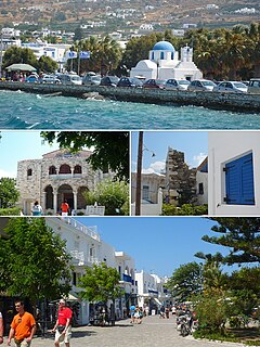
WMykonos is a Greek island, part of the Cyclades, lying between Tinos, Syros, Paros and Naxos. The island has an area of 85.5 square kilometres (33.0 sq mi) and rises to an elevation of 341 metres at its highest point. There are 10,134 inhabitants according to the 2011 census, most of whom live in the largest town, Mykonos, which lies on the west coast. The town is also known as Chora.
 W
WNaxos and Lesser Cyclades is a municipality in the Naxos regional unit, South Aegean region, Greece. The seat of the municipality is the town Naxos (city). The municipality consists of the Cycladic island of Naxos and the islands of the Lesser Cyclades: Donousa, Irakleia, Koufonisia, Schoinoussa and several smaller islands. The municipality has an area of 495.867 km2.
 W
WNisyros also spelled Nisiros is a volcanic Greek island and municipality located in the Aegean Sea. It is part of the Dodecanese group of islands, situated between the islands of Kos and Tilos.
 W
WParos is a Greek island in the central Aegean Sea. One of the Cyclades island group, it lies to the west of Naxos, from which it is separated by a channel about 8 kilometres wide. It lies approximately 150 km south-east of Piraeus. The Municipality of Paros includes numerous uninhabited offshore islets totaling 196.308 square kilometres (75.795 sq mi) of land. Its nearest neighbor is the municipality of Antiparos, which lies to its southwest. In ancient Greece, the city-state of Paros was located on the island.
 W
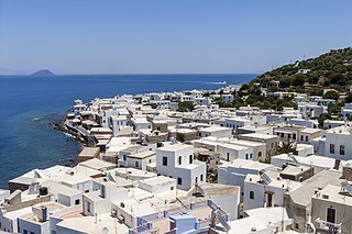
WPatmos is a small Greek island in the Aegean Sea. It is perhaps best known today as the location the disciple / apostle John received the visions found in the Book of Revelation of the New Testament, and where the book was written.
 W
WRhodes is the largest of the Dodecanese islands of Greece and is also the island group's historical capital. Administratively the island forms a separate municipality within the Rhodes regional unit, which is part of the South Aegean administrative region. The principal town of the island and seat of the municipality is Rhodes. The city of Rhodes had 50,636 inhabitants in 2011. It is located northeast of Crete, southeast of Athens. Rhodes' nickname is The Island of the Knights, named after the Knights of Saint John of Jerusalem, who ruled the island from 1310 to 1522.
 W
WSantorini, officially Thira and classic Greek Thera, is an island in the southern Aegean Sea, about 200 km (120 mi) southeast from the Greek mainland. It is the largest island of a small, circular archipelago, which bears the same name and is the remnant of a volcanic caldera. It forms the southernmost member of the Cyclades group of islands, with an area of approximately 73 km2 (28 sq mi) and a 2011 census population of 15,550. The municipality of Santorini includes the inhabited islands of Santorini and Therasia, as well as the uninhabited islands of Nea Kameni, Palaia Kameni, Aspronisi and Christiana. The total land area is 90.623 km2 (34.990 sq mi). Santorini is part of the Thira regional unit.
 W
WSerifos is a Greek island municipality in the Aegean Sea, located in the western Cyclades, south of Kythnos and northwest of Sifnos. It is part of the Milos regional unit. The area is 75.207 square kilometres (29.038 sq mi) and the population was 1,420 at the 2011 census. It is located about 170 kilometres ESE of the Athenian port of Piraeus.
 W
WSikinos is a Greek island and municipality in the Cyclades. It is located midway between the islands of Ios and Folegandros. Sikinos is part of the Thira regional unit.
 W
WSymi, also transliterated as Syme or Simi, is a Greek island and municipality. It is mountainous and includes the harbor town of Symi and its adjacent upper town Ano Symi, as well as several smaller localities, beaches, and areas of significance in history and mythology. Symi is part of the Rhodes regional unit.
 W
WSyros, or Siros or Syra is a Greek island in the Cyclades, in the Aegean Sea. It is located 78 nautical miles (144 km) south-east of Athens. The area of the island is 83.6 km2 (32 sq mi) and it has 21,507 inhabitants.
 W
WTílos is a small Greek island and municipality located in the Aegean Sea. It is part of the Dodecanese group of islands, and lies midway between Kos and Rhodes. It has a population of 780 inhabitants. Along with the uninhabited offshore islets of Antitilos and Gaidaros, it forms the Municipality of Tilos, which has a total land area of 64.525 square kilometres (24.913 sq mi). Tilos is part of the Rhodes regional unit.
 W
WTinos is a Greek island situated in the Aegean Sea. It is located in the Cyclades archipelago. In antiquity, Tinos was also known as Ophiussa and Hydroessa. The closest islands are Andros, Delos, and Mykonos. It has a land area of 194.464 square kilometres (75.083 sq mi) and a 2011 census population of 8,636 inhabitants.