 W
WThis is a list of all Pacific typhoons that have had their names retired by the Japan Meteorological Agency. A total of 54 typhoon names have been retired since the start of official tropical cyclone naming in the western North Pacific Ocean in 2000. Tropical cyclone names are retired by the World Meteorological Organization (WMO) in a meeting in January or February. Those typhoons that have their names retired tend to be exceptionally destructive storms. Several names were removed or altered naming list for various reasons other than retirement. Collectively, retired typhoons have caused over $108 billion in damage (2021 USD), as well as over 12,000 deaths.
 W
WSince 1963, the Philippine Atmospheric, Geophysical and Astronomical Services Administration (PAGASA) has assigned local names to a tropical cyclone should it move into or form as a tropical depression in their area of responsibility located between 135°E and 115°E and between 5°N-25°N, even if the cyclone has had an international name assigned to it. All three agencies that have assigned names to tropical cyclones within the Western Pacific have retired the names of significant tropical cyclones, with the PAGASA retiring names if a cyclone has caused at least ₱1 billion in damage and/or have caused at least 300 deaths within the Philippines.
 W
WTyphoon Bess struck Japan in early August 1982, resulting in severe damage. The eleventh tropical storm, sixth typhoon, and first super typhoon of the 1982 Pacific typhoon season, the system first developed on July 21. Two days later, it was upgraded into a tropical storm, and subsequently began to intensify while tracking northwest. Bess attained typhoon intensity on July 24, before it briefly turned southwest. After turning north-northwest, the typhoon entered a period of rapid intensification and late on July 28 reached peak winds of 230 km/h (145 mph). After turning north, Bess began to weaken as it encountered less favorable conditions. On August 1, Bess was downgraded into a tropical storm. Shortly after that, the storm struck southeastern Japan, and on August 2 merged with a low pressure area atop of the Sea of Japan.
 W
WTyphoon Bess, known in the Philippines as Typhoon Susang, was responsible for the disappearance of a United States Air Force weather reconnaissance aircraft. Developing out of a poorly organized system on October 8 to the east of the Philippines, Bess featured two centers of circulation. Initially the southern low was monitored; however, a low to the north soon became the dominant center. Tracking generally west-northwestward, the storm gradually intensified before striking northern Luzon as a minimal typhoon on October 11. Temporary weakening took place due to interaction with land. After moving back over water the following morning, Bess regained typhoon intensity. This was short-lived though, as conditions surrounding the cyclone soon caused it to weaken. Now moving due west, the weakening storm eventually struck Hainan Island as a tropical storm on October 12 before diminishing to a tropical depression. The depression briefly moved back over water before dissipating in northern Vietnam on October 14.
 W
WSevere Tropical Storm Bilis, known in the Philippines as Tropical Storm Florita, was a weak tropical cyclone in July 2006 that caused significant damage to areas of the Philippines, Taiwan, and southeastern China. The word Bilis, submitted by the Philippines, means 'speed' or 'swiftness' in Tagalog.
 W
WTyphoon Bopha, known in the Philippines as Typhoon Pablo, was the strongest tropical cyclone on record to ever affect the southern Filipino island of Mindanao, making landfall as a Category 5 super typhoon with winds of 175 mph (280 km/h). The twenty-fourth tropical storm, along with being the fourth and final super typhoon of the 2012 Pacific Typhoon season, Bopha originated unusually close to the equator, becoming the second-most southerly Category 5 super typhoon, reaching a minimum latitude of 7.4°N on December 3, 2012, as only Typhoon Louise-Marge of 1964 came closer to the equator at this strength, at 7.3°N. After first landfalling in Palau, where it destroyed houses, disrupted communications and caused power outages, flooding and uprooted trees, Bopha made landfall late on December 3 on Mindanao, an island that had been devastated by the much weaker Tropical Storm Washi in December 2011. The storm caused widespread destruction on Mindanao, leaving thousands of people homeless and killing 1901 people.
 W
WTyphoon Chanchu, known in the Philippines as Typhoon Caloy, was the most intense typhoon in the South China Sea in the month of May according to the Hong Kong Observatory (HKO). The first named storm of the 2006 Pacific typhoon season, Chanchu formed on May 8 in the vicinity of the Federated States of Micronesia and progressed westward. It gradually intensified into a tropical storm and later severe tropical storm before moving through the Philippines. On May 13, Chanchu entered the South China Sea and became a typhoon, according to the Japan Meteorological Agency (JMA). Warm waters and favorable outflow allowed the storm to quickly intensify to peak maximum sustained winds of 175 km/h (110 mph) on May 15. Around that time, the typhoon turned sharply to the north toward southeastern China. Chanchu weakened as it curved to the northeast, making landfall near Shantou, Guangdong on May 17 as a severe tropical storm. The government of China considered Chanchu the earliest typhoon to make landfall in the province. On the next day, the storm emerged into the East China Sea, becoming extratropical on May 19 before dissipating west of Kyushu.
 W
WTyphoon Chataan, known in the Philippines as Typhoon Gloria, was the deadliest natural disaster in the history of Chuuk, a state in the Federated States of Micronesia (FSM). The typhoon formed on June 28, 2002, near the FSM, and for several days it meandered while producing heavy rainfall across the region. On Chuuk, the highest 24-hour precipitation total was 506 mm (19.9 in), which was greater than the average monthly total. The rain produced floods up to 1.5 m (4.9 ft) deep, causing landslides across the island that killed 47 people. There was also one death on nearby Pohnpei, and damage in the FSM totaled over $100 million.
 W
WTyphoon Fanapi, known in the Philippines as Typhoon Inday, was a damaging and deadly typhoon that struck Taiwan and southeastern China in September 2010. It was the eleventh tropical storm and fourth typhoon of the very inactive season. The storm formed on September 14 east of the Philippines and moved slowly for several days, initially to the northwest, then curving to the northeast before turning westward due to a ridge to the north. During this time, Fanapi intensified to reach 10 minute maximum sustained winds of 175 km/h (110 mph). Fanapi made its first landfall on September 19 over Hualien, Taiwan, becoming the first typhoon to hit the island since Typhoon Morakot in August 2009. Later that day made a final landfall in Fujian, China. The storm dissipated on September 21 over southern China.
 W
WTyphoon Fitow, known in the Philippines as Typhoon Quedan, was the strongest typhoon to make landfall in Mainland China during October since 1949. The 21st named storm of the 2013 Pacific typhoon season, Fitow developed on September 29 to the east of the Philippines. It initially tracked north-northwestward, gradually intensifying into a tropical storm and later to typhoon status, or with winds of at least 120 km/h (75 mph). Fitow later turned more to the west-northwest due to an intensifying ridge to the east, bringing the typhoon over the Ryukyu Islands with peak winds of 140 km/h (85 mph) on October 5. The next day, the typhoon struck China at Fuding in Fujian province. Fitow quickly weakened over land, dissipating on October 7.
 W
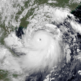
WTyphoon Haiyan, known in the Philippines as Super Typhoon Yolanda, was one of the most powerful tropical cyclones ever recorded. On making landfall, Haiyan devastated portions of Southeast Asia, particularly the Philippines. It is one of the deadliest Philippine typhoons on record, killing at least 6,300 people in that country alone. In terms of JTWC-estimated 1-minute sustained winds, Haiyan is tied with Meranti in 2016 for being the second strongest landfalling tropical cyclone on record only behind Goni of 2020. In January 2014, bodies were still being found. Haiyan was also the most intense tropical cyclone worldwide in 2013.
 W
WTyphoon Ike was the second deadliest tropical cyclone in the 20th century in the Philippines, where it was known as Typhoon Nitang. Ike originated from an area of disturbed weather southeast of Guam on August 21, 1984, and five days later, developed into a tropical depression. Following an increase in organization, the depression attained tropical storm intensity on August 27. Initially tracking west-southwest, the storm gradually gained strength as wind shear resulted relaxed and Ike became a typhoon on August 30. Continuing to rapidly intensity, Ike turned west and attained peak intensity on September 1, with the Japan Meteorological Agency estimating winds of 170 km/h (105 mph). At around 14:00 UTC that day, Ike made landfall on the northeastern tip of Mindanao. The cyclone emerged into the South China Sea on September 3 as a tropical storm before re-intensifying into a typhoon and moving onshore Hainan. Ike then struck the Chinese mainland as a tropical storm in the Guangxi and dissipated on September 6.
 W
WTyphoon Imbudo, known in the Philippines as Typhoon Harurot, was a powerful typhoon that struck the Philippines and southern China in July 2003. The seventh named storm and fourth typhoon of the season, Imbudo formed on July 15 to the east of the Philippines. The storm moved generally west-northward for much of its duration due to a ridge to the north. Favorable conditions allowed Imbudo to intensify, gradually at first before undergoing rapid deepening on July 19. After reaching typhoon status, Imbudo strengthened further to peak 10–minute sustained winds of 165 km/h (105 mph) on July 20. The typhoon made landfall on northern Luzon near peak intensity on July 22, but quickly weakened over land. Once in the South China Sea, Imbudo re-intensified slightly before making its final landfall in southern China near Yangjiang on July 24, dissipating the next day.
 W
WTyphoon Jane, known in Japan as Jane Typhoon (ジェーン台風), was a catastrophic and deadly tropical cyclone that left significant effects to Japan during the 1950 Pacific typhoon season. It caused over 398 reported deaths and 141 to be missing, mainly due to the landslides and flooding. It also destroyed some battle and cargo ships. The sixth reported typhoon of the season, Jane was first mentioned in weather maps as a tropical depression to the east of the Philippines. It quickly strengthened to a tropical storm as it moved to the northwest. It then curved to the northeast, reaching its peak intensity of 185 km/h before weakening and striking Minami in Tokushima Prefecture on September 3 as a Category 2 typhoon. It quickly weakened, passing through the Awaji Island and Kobe before becoming extratropical in the Sea of Japan on the same day. The extratropical remnants of the system persisted until it was no longer tracked on September 7.
 W
WTyphoon Karen was the most powerful tropical cyclone to strike the island of Guam, and has been regarded as one of the most destructive events in the island's history. It was first identified as a tropical disturbance on November 6, 1962, well to the southeast of Truk. Over the following two days, the system tracked generally northward and quickly intensified. Karen became a tropical storm late on November 7, and within two days it explosively intensified into a Category 5-equivalent super typhoon on the Saffir–Simpson scale. Turning westward, the typhoon maintained its intensity and struck Guam with winds of 280 km/h (175 mph) on November 11. Once clear of the island, it strengthened slightly and reached its peak intensity on November 13 with winds of 295 km/h (185 mph) and a barometric pressure of 894 mb. The storm then gradually turned northward as it weakened, brushing the Ryukyu Islands on November 15, before moving east-northeastward over the open waters of the Pacific. Karen continued to weaken and transitioned into an extratropical cyclone on November 17 before losing its identity the following day between Alaska and Hawaii.
 W
WTyphoon Ketsana, known in the Philippines as Tropical Storm Ondoy, was the second-most devastating tropical cyclone of the 2009 Pacific typhoon season, causing $1.15 billion in damages and 921 fatalities, only behind Morakot earlier in the season, which caused 789 deaths and damages worth $6.2 billion. Ketsana was the sixteenth tropical storm, and the eighth typhoon of the season. It was the most devastating tropical cyclone to hit Manila, surpassing Typhoon Patsy (Yoling) in 1970.
 W
WTyphoon Longwang, known in the Philippines as Typhoon Maring, was the deadliest tropical cyclone to impact China during the 2005 Pacific typhoon season. Longwang was first identified as a tropical depression on September 25 north of the Mariana Islands. Moving along a general westward track, the system quickly intensified and reached typhoon status on September 27. After reaching Category 4-equivalent intensity on the Saffir–Simpson hurricane scale, adverse atmospheric conditions along with internal structural changes resulted in temporary weakening. The structural change culminated in Longwang becoming an annular typhoon and prompted re-intensification. The storm attained peak strength with winds of 175 km/h (110 mph) and a pressure of 930 mbar on October 1 as it approached Taiwan. Interaction with the mountainous terrain of the island and further structural changes caused some weakening before the typhoon made landfall near Hualien City early on October 2. Crossing the island in six hours, Longwang emerged over the Taiwan Strait before moving onshore again later that day, this time in Fujian Province, China as a minimal typhoon. Once over mainland China, the storm quickly weakened and ultimately dissipated late on October 3.
 W
WTropical Storm Lucille was the first tropical cyclone to have its name retired in the Western Pacific basin. Lucille was identified as a weak tropical depression on May 25, 1960, to the east of the Philippines. Tracking northwestward, the system failed to develop and warnings on it were discontinued on May 27. At the same time, a second system began organizing along the west coast of Luzon. The two systems ultimately merged into one over the Philippines between May 28 and 29. Now tracking northeastward, the system re-intensified and became a tropical storm on May 30. Lucille attained its peak intensity later that day with winds of 85 km/h (50 mph). As it accelerated over open waters, the system brushed the islands of Iwo Jima and Chichi-jima before transitioning into an extratropical cyclone on June 1. The remnants of Lucille were last noted on June 4 near the International Date Line.
 W
WTyphoon Maemi, known in the Philippines as Typhoon Pogi, was the most powerful typhoon to strike South Korea since record-keeping began in the country in 1904. Maemi formed on September 4, 2003 from a disturbance in a monsoon trough in the western Pacific Ocean. It slowly intensified into Tropical Storm Maemi while moving northwestward, becoming a typhoon on September 8. That day, favorable conditions facilitated more rapid strengthening; the storm developed a well-defined eye and reached peak maximum sustained winds of 195 km/h (120 mph). While near peak intensity, Maemi decelerated and began turning to the north-northeast. Soon after, the eyewall passed over the Japanese island of Miyako-jima on September 10 and produced an air pressure reading of 912 mbar (26.9 inHg), the fourth-lowest recorded in the nation. Due to warm waters, Maemi was able to maintain much of its intensity before it made landfall just west of Busan, South Korea, on September 12. The typhoon became extratropical in the Sea of Japan the next day, although its remnants persisted for several days, lashing northern Japan with strong winds.
 W
WTyphoon Matsa, known in the Philippines as Typhoon Gorio, was the second of eight Pacific tropical cyclones to make landfall on China during the 2005 Pacific typhoon season. The ninth tropical storm and fifth typhoon of the season, Matsa developed on July 30 to the east of the Philippines. Matsa intensified as it tracked northwestward, and attained peak 10-minute sustained winds of 150 km/h (90 mph) near Taiwan before weakening and striking the Chinese province of Zhejiang on August 5. The system continued northward into the Yellow Sea, and on August 7 Matsa became extratropical after again moving ashore along the Liaodong Peninsula. Matsa is a Laotian name for a lady fish.
 W
WTyphoon Mawar was a strong super typhoon that battered southern Japan and caused great damage across the country. The eleventh named storm and ninth typhoon of the 2005 Pacific typhoon season, Mawar originated from a cluster of thunderstorms that persisted near the Mariana Islands. On August 19, the JMA reported that a tropical depression formed from these thunderstorms, at the same time that Tropical Depression 12W became a tropical storm, naming it Guchol. The JTWC issued a TCFA on the same day, before both agencies upgraded the system to a tropical storm, earning the name Mawar from the JMA. Influenced by a subtropical ridge to the northeast, the small Mawar rapidly strengthened, reaching Category 4 super typhoon status on August 22, before it slowly weakened due to unfavorable conditions. It continued to weaken, before making landfall near Tokyo, Japan on August 25. It recurved to the northeast before transitioning to an extratropical low on August 27. The remnants of Mawar persisted for three more days before dissipating on August 30.
 W
WTyphoon Mike, known in the Philippines as Typhoon Ruping, of 1990 was the strongest typhoon to hit the Philippines since Typhoon Irma in 1981. Forming from an area of persistent convection over the Caroline Islands, Mike was first designated on November 6, 1990 and moved generally westward. Later that day, the depression strengthened to Tropical Storm Mike near Yap. Mike became a typhoon early on November 9, and subsequently entered a period of rapid deepening. Late on November 10, the typhoon reached its maximum intensity of 115 mph (185 km/h), as estimated by the Japanese Meteorological Agency. After weakening slightly, Mike made landfall in the central Philippines, after weakening slightly. The storm weakened considerably due to land interaction, only to briefly re-intensify on November 14. Typhoon Mike turned west-northwest and later north-northwest, avoiding land interaction with Vietnam. Vertical wind shear increased, and on November 15, Mike weakened below typhoon intensity. Early the next day, the storm passed over western Hainan Island, and degraded to a tropical depression that night. After briefly emerging into the Gulf of Tonkin, Mike passed over Northern Vietnam and southern China, where it dissipated on November 18.
 W
WTyphoon Mireille, known in the Philippines as Typhoon Rosing, was the costliest typhoon on record, until it was surpassed by Typhoon Hagibis in 2019. Striking Japan in September 1991, it became the 20th named storm of the 1991 Pacific typhoon season, Mireille formed on September 13 from the monsoon trough near the Marshall Islands. It moved westward for several days as a small system, steered by the subtropical ridge to the north. The storm rapidly intensified to typhoon status on September 16, and several days later passed north of Saipan in the Northern Marianas Islands. Mireille intensified further after deleterious effects from a nearby tropical storm subsided. On September 22, the American-based Joint Typhoon Warning Center (JTWC) estimated maximum 1‑minute sustained winds of 240 km/h (150 mph), and on the next day, the official Japan Meteorological Agency (JMA) estimated 10‑minute sustained winds of 185 km/h (115 mph). The typhoon weakened slightly while turning northward, passing just east of Miyako-jima and later to the west of Okinawa. On September 27, Mireille made landfall near Nagasaki in southwestern Japan with winds of 175 km/h (110 mph), the strongest since Typhoon Nancy in 1961. The storm accelerated to the northeast through the Sea of Japan, moving over Hokkaido before becoming extratropical on September 28. The remnants of Mireille continued to the east, passing through the Aleutian Islands of Alaska on October 1.
 W
WTyphoon Morakot, known in the Philippines as Typhoon Kiko, was the deadliest typhoon to impact Taiwan in recorded history. The eighth named storm and fourth typhoon of the 2009 Pacific typhoon season, Morakot wrought catastrophic damage in Taiwan, leaving 673 people dead and 26 missing, and causing roughly NT$110 billion (US$3.3 billion) in damages. Morakot originated as a tropical depression in the West Pacific on August 2. The system initially moved northeastward, before taking a westward track, developing into a tropical storm on August 3, with the JMA giving it the name Morakot. The storm gradually strengthened as it moved towards Taiwan, intensifying into a Category 1-equivalent typhoon on August 5. Morakot reached its peak intensity on August 7, with a minimum central pressure of 945 millibars (27.9 inHg), maximum 10-minute sustained winds of 140 km/h (85 mph), and maximum 1-minute sustained winds of 150 km/h (90 mph). Afterward, Morakot's forward motion slowed and the system gradually weakened, making landfall on central Taiwan later that day as a severe tropical storm. Over the next day, Morakot slowly meandered over Taiwan, before emerging into the Taiwan Strait and turning northward, making landfall on Mainland China on August 9. Afterward, Morakot accelerated northward while gradually weakening, before later turning northeastward. On August 11, Morakot degenerated into a remnant low in the East China Sea, before dissipating on August 13, over northern Japan.
 W
WTyphoon Nabi, known in the Philippines as Typhoon Jolina, was a powerful typhoon that struck southwestern Japan in September 2005. The 14th named storm of the 2005 Pacific typhoon season, Nabi formed on August 29 to the east of the Northern Mariana Islands. It moved westward and passed about 55 km (35 mi) north of Saipan on August 31 as an intensifying typhoon. On the next day, the Joint Typhoon Warning Center upgraded the storm to super typhoon status, with winds equivalent to that of a Category 5 hurricane on the Saffir–Simpson Hurricane Scale. The Japan Meteorological Agency estimated peak ten-minute winds of 175 km/h (110 mph) on September 2. Nabi weakened while curving to the north, striking the Japanese island of Kyushu on September 6. After brushing South Korea, the storm turned to the northeast, passing over Hokkaido before becoming extratropical on September 8, before dissipating on September 12.
 W
WTyphoon Omar of 1992, known in the Philippines as Typhoon Lusing, was the strongest and costliest typhoon to strike Guam since Typhoon Pamela in 1976. The cyclone formed on August 23 from the monsoon trough across the western Pacific Ocean. Moving westward, Omar slowly intensified into a tropical storm, although another tropical cyclone nearby initially impeded further strengthening. After the two storms became more distant, Omar quickly strengthened into a powerful typhoon. On August 28, it made landfall on Guam with winds of 195 km/h (120 mph). The typhoon reached its peak intensity the next day, with estimated 1‑minute winds of 240 km/h (150 mph), making it a "super typhoon" according to the Joint Typhoon Warning Center (JTWC). Omar weakened significantly before striking eastern Taiwan on September 4, proceeding into eastern China the next day and dissipating on September 9.
 W
WTyphoon Ophelia was a long-lived and powerful tropical cyclone that had devastating impacts on the small atoll of Ulithi in the Caroline Islands. Forming as a tropical depression on November 21, 1960 near Enewetak Atoll, the incipient cyclone struggled to develop. Moving haphazardly along an s-shaped track over the western Pacific Ocean, it degenerated into a disturbance two days later. By November 27, the system reorganized and was classified a tropical depression for a second time well to the southeast of Guam. Moving slowly west-southwest, it steadily intensified into a tropical storm later that day and further into a typhoon on November 29 as it gained a steady westward track. The following day, the eye of Ophelia passed directly over Ulithi atoll with winds estimated at 230 km/h (145 mph).
 W
WTyphoon Parma, known in the Philippines as Typhoon Pepeng, was the second typhoon to affect the Philippines within the span of a week during September 2009.
 W
WTyphoon Pongsona was the last typhoon of the 2002 Pacific typhoon season, and was the second costliest United States disaster in 2002, only behind Hurricane Lili. The name "Pongsona" was contributed by North Korea for the Pacific tropical cyclone list and is the Korean name for the garden balsam. Pongsona developed out of an area of disturbed weather on December 2, and steadily intensified to reach typhoon status on December 5. On December 8 it passed through Guam and the Northern Mariana Islands while near its peak winds of 175 km/h. It ultimately turned to the northeast, weakened, and became extratropical on December 11. Typhoon Pongsona produced strong wind gusts peaking at 290 km/h, which left the entire island of Guam without power and destroyed about 1,300 houses. With strong building standards and experience from repeated typhoon strikes, there were no fatalities directly related to Pongsona, although there was one indirect death from flying glass. Damage on the island totaled over $730 million, making Pongsona among the five costliest typhoons on the island. The typhoon also caused Extreme damage on Rota and elsewhere in the Northern Mariana Islands, and as a result of its impact the name was retired.
 W
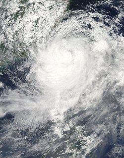
WTyphoon Rammasun, known in the Philippines as Typhoon Glenda, was one of the only three Category 5 super typhoons on record in the South China Sea, with the other ones being Pamela in 1954 and Meranti in 2016. Rammasun had destructive impacts across the Philippines, South China, and Vietnam in July 2014. Rammasun is a Siamese word for thunder god. After Lingling and Kajiki earlier in 2014, Rammasun became the third tropical cyclone, and first typhoon to directly impact the Philippines in 2014. The ninth named storm and the third typhoon of the annual typhoon season, Rammasun formed in the Intertropical Convergence Zone, an area near the equator where the northeast and southeast trade winds come together, and slowly drifted northwest. Having passed through the islands of Micronesia, the system turned west and quickly moved under the influence of a subtropical ridge (STR). Rammasun posed a significant threat to the Philippine island of Luzon, as it was expected to reach typhoon intensity before making landfall there. Though initially forecast to make landfall in Cagayan Valley, the storm followed a more westerly path and was later forecast to make landfall in the Bicol Region and then pass through Bataan and Zambales before brushing past Metro Manila.
 W
WTyphoon Rananim, known in the Philippines as Typhoon Karen, was the strongest typhoon to make landfall on the Chinese province of Zhejiang since 1956. It formed on August 6, 2004, intensifying into a tropical storm on August 8. Rananim gradually intensified, initially moving northward before turning to the northwest and attaining typhoon status. After developing a small eye, the typhoon attained peak winds of 150 km/h (90 mph) as it passed between Taiwan and Okinawa. On August 12, Rananim moved ashore in China, and it dissipated three days later. The name Rananim means "hello" in the Chuukese language.
 W
WTyphoon Roy, known in the Philippines as Typhoon Asiang, was the second-most intense January tropical cyclone on record in the Western Pacific basin. Forming out of an area of disturbed weather on January 7, 1988, Roy quickly intensified as it moved through the Marshall Islands. By January 9, the storm intensified into a typhoon and attained its peak intensity the following day. At its peak, sustained winds reached 215 km/h (135 mph). Slight weakening took place before the storm moved through the Mariana Islands. Continuing westward, the system eventually struck the Philippines as a minimal typhoon before dissipating over the South China Sea on January 19.
 W
WTyphoon Rusa was the most powerful typhoon to strike South Korea in 43 years. It was the 21st JTWC tropical depression, the 15th named storm, and the 10th typhoon of the 2002 Pacific typhoon season. It developed on August 22 from the monsoon trough in the northwestern Pacific Ocean, well to the southeast of Japan. For several days, Rusa moved to the northwest, eventually intensifying into a powerful typhoon. On August 26, the storm moved across the Amami Islands of Japan, where Rusa left 20,000 people without power and caused two fatalities. Across Japan, the typhoon dropped torrential rainfall peaking at 902 mm (35.5 in) in Tokushima Prefecture.
 W
WTyphoon Saomai, known in the Philippines as Typhoon Juan, was considered the most powerful typhoon on record to strike the east coast of the People's Republic of China. It was the eighth tropical storm, fifth typhoon, and third super typhoon of the 2006 Pacific typhoon season recognized by the Joint Typhoon Warning Center. According to the Japan Meteorological Agency, Saomai was the seventh tropical storm and fifth typhoon of the season. The name "Saomai" was submitted by Vietnam, and is from the Vietnamese word for "morning star", a reference to the planet Venus.
 W
WTyphoon Sudal, known in the Philippines as Typhoon Cosme, was the strongest typhoon to strike the island of Yap in the Federated States of Micronesia (FSM) in about 50 years. Yap is one of the four administrative divisions of the FSM. The entire island, only 17 km (11 mi) in length, experienced typhoon force winds, and 90% of the structures were damaged or destroyed. Damage was most severe in southeastern Yap, where the eyewall struck and winds exceeded 185 km/h (115 mph), but the center of the typhoon passed south of the island.
 W
WTropical Storm Thelma, known in the Philippines as Tropical Storm Uring, was one of the deadliest tropical cyclones in Philippine history, killing at least 5,081 people. Forming out of a tropical disturbance on November 1, 1991, several hundred kilometers north-northeast of Palau, the depression that would become Thelma tracked generally westward. After turning southwestward in response to a cold front, the system intensified into a tropical storm on November 4 as it approached the Philippines. Hours before moving over the Visayas, Thelma attained its peak intensity with estimated ten-minute sustained winds of 75 km/h (45 mph) and a barometric pressure of 992 mbar. Despite moving over land, the system weakened only slightly, emerging over the South China Sea on November 6 while retaining gale-force winds. Thelma ultimately succumbed to wind shear and degraded to a tropical depression. On November 8, the depression made landfall in Southern Vietnam before dissipating hours later.
 W
WTyphoon Tingting was a destructive tropical cyclone that produced record-breaking rains in Guam. The eighth named storm of the 2004 Pacific typhoon season, Tingting originated from a tropical depression over the open waters of the western Pacific Ocean. The storm gradually intensified as it traveled northwest, becoming a typhoon on June 28 and reaching its peak the following day while passing through the Mariana Islands. After maintaining typhoon intensity for three days, a combination of dry air and cooler sea surface temperatures caused the storm to weaken as it traveled northward. On July 1, the storm passed by the Bonin Islands, off the coast of Japan, before moving out to sea. By July 4, Tinting had transitioned into an extratropical cyclone. The remnants were last reported by the Japan Meteorological Agency, the Regional Specialized Meteorological Center for the western Pacific basin, near the International Date Line on July 13.
 W
WTyphoon Utor, known in the Philippines as Typhoon Labuyo, was the 15th depression, the 2nd typhoon and the first super typhoon in the 2013 typhoon season.
 W
WTropical Storm Vamei was a Pacific tropical cyclone that formed closer to the equator than any other tropical cyclone on record. The last storm of the 2001 Pacific typhoon season, Vamei developed on December 26 at 1.4° N in the South China Sea. It strengthened quickly and made landfall along extreme southeastern Peninsular Malaysia. Vamei rapidly weakened into a remnant low over Sumatra on December 28, and the remnants eventually re-organized in the North Indian Ocean. Afterward, the storm encountered strong wind shear once again, and dissipated on January 1, 2002.
 W
WSevere Tropical Storm Washi, known in the Philippines as Tropical Storm Sendong, was a late-season tropical cyclone that caused catastrophic damage in the Philippines in late 2011. Washi made landfall over Mindanao, a major region in the Philippines, on December 16. Washi weakened slightly after passing Mindanao, but regained strength in the Sulu Sea, and made landfall again over Palawan on December 17.
 W
WTyphoon Xangsane, known in the Philippines as Typhoon Milenyo, was a typhoon that affected the Philippines, Vietnam, and Thailand during the 2006 Pacific typhoon season. The name Xangsane was submitted by Laos and means elephant.