 W
WThis article lists hill forts in Scotland. There are 1,695 in the country. Hill forts typically date from the Bronze and Iron Ages. Typically, they only survive as earthworks today, although remains of vitrified forts are found throughout Scotland.
 W
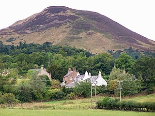
WBennachie is a range of hills in Aberdeenshire, Scotland. It has several tops, the highest of which, Oxen Craig, has a height of 528 metres (1,732 ft). Though not particularly high, compared to other peaks within Scotland, the mountain is very prominent, owing to its isolation and the relative flatness of the surrounding terrain, and dominates the skyline from several viewpoints.
 W
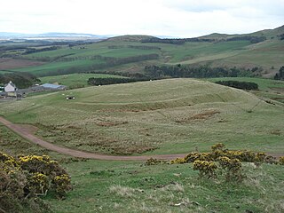
WThe Black Hill in South Lanarkshire is owned by the National Trust for Scotland. It overlooks the Clyde Valley, and is the location of a burial cairn from the Bronze Age and an Iron Age fortress.
 W
WBlack Meldon is a prehistoric site, a hillfort near the village of Lyne and about 4 miles (6 km) west of Peebles, in the Scottish Borders, Scotland. It is a Scheduled Monument.
 W
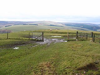
WBlackcastle Hill is an Iron Age hill fort south of Innerwick, East Lothian, Scotland. It is near Cocklaw in the Lammermuir Hills at grid reference NT729724, at a height of 280 metres (920 ft) above sea level. The fort has a single defensive bank.
 W
WCaskieben Caskieben was a palisaded tower built by the Garviach family during the 12th-century Norman expansion into Scotland. It stood on a low, circular mound surrounded by a 2 metre deep, 15 metre wide moat.
 W
WCastle Law is a hill south west of Fairmilehead in the Pentland Hills in Midlothian, Scotland.
 W
WCaterthun, or the Caterthuns, is a ridge of hills near the city of Brechin in Angus, Scotland. The Caterthuns are notable for being the site of two Iron Age forts known as the White Caterthun and the Brown Caterthun which are designated as a scheduled monument.
 W
WThe fort of Clatchard Craig was located on a hill of the same name by the Tay. A human presence on the site has been identified from the neolithic period onward and the fort itself was occupied from the sixth century AD until at least the eighth century. It stood close to several places which were centres of secular and religious power during the early Middle Ages including Abernethy, Forteviot, Scone and Moncreiffe. As such it seems to have been an important stronghold of the Picts.
 W
WCluny Hill is a hill on the East side of Forres, Scotland.
 W
WCraig Phadrig is a forested hill on the western edge of Inverness, Scotland. A hill fort on the summit is generally supposed to have been the base of the Pictish king Bridei mac Maelchon. The hill rises to 172 metres (564 ft) above sea level, and overlooks the Beauly Firth to the north and the mouth of the River Ness to the north-east. The hill is currently owned and managed by Forestry and Land Scotland.
 W
WThe Doon of May is a conifer plantation associated with an Iron Age hill fort in Dumfries and Galloway, south-west Scotland. Located around 14 kilometres (8.7 mi) west of Wigtown on the Machars peninsula, it is in the parish of Mochrum in the traditional county of Wigtownshire. The plantation was purchased from the Forestry Commission by the Tinne Beag Workers’ Co-operative in 1999 and since then the co-operative has been managing the woodland for sustainable use of both timber and non-timber forest products, while increasing biodiversity and restoring native vegetation types where possible.
 W
WThe Doune of Relugas is a hill fort located 9.25 kilometres (5.75 mi) south south west of Forres in Moray, Scotland. It is situated on a rocky knoll rising to approximately 400 feet (120 m) above ordnance datum and forming the south east part of the promontory at the confluence of the River Findhorn and the River Divie. The site commands an uninterrupted view of the valley of the Findhorn as far as Culbin Sands, 9 miles to the north on the shore of the Moray Firth.
 W
WDumglow is the highest peak of the Cleish Hills in Perth and Kinross, Scotland. It is located north of Dunfermline. An ancient fort lies on its summit.
 W
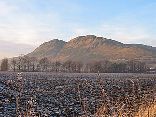
WDumyat or Dunmyat is a hill at the western extremity of the Ochil Hills in central Scotland. The name is thought to originate from Dun of the Maeatae.
 W
WDùn a' Choin Duibh is a hillfort located near Torinturk, Argyll and Bute, Scotland. According to the local shanachies, the fort is named after a black wolfhound which was half wolf, which defended the fort. The fort provides views to the Inner Hebridean islands of Gigha, Islay and Jura and further to the Mull of Kintyre and Ireland.
 W
WDun Cruinn is a prehistoric site about 10 kilometres (6.2 mi) north-west of Portree, on the Isle of Skye, Scotland. It is on the Skerinish Peninsula, between Loch Snizort Beag and Loch Eyre.
 W
WDùn Dubh is a hillfort, located on the Inner Hebridean island of Coll. The fort is one of three associated with a local tradition which states that they were once the fortresses of Norsemen before being defeated by a Maclean chieftain. The early 20th century antiquary Erskine Beveridge considered it as one of the four most interesting fortifications, on Coll. The site is located at grid reference NM18365942.
 W
WDùn Eibhinn, also known as Dun Evan, Dun Eivan or Fort of Eyvind, is a hillfort located on the Inner Hebridean island of Colonsay, Scotland. The site is located at grid reference NR38209437.
 W
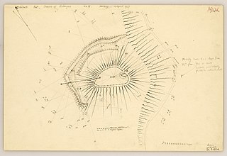
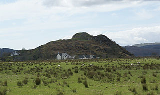
WDùn Èistean is a multi-period archaeological site on an inter-tidal sea stack on the north east coast of the Isle of Lewis, near the village of Knockaird in the area of Nis (Ness) in the Western Isles of Scotland. It is accorded the status of traditional stronghold of Clan Morrison, once a highly powerful family within the Lordship of the Isles, in local oral tradition. The ruins of two large buildings and groups of interconnecting cellular structures can be seen amongst the grassy tussocks on the top of the island, as well as an artificial pond and a low turf wall enclosing the site. The most prominent feature of the site is a large circular mound of rubble situated on the highest point of the stack, on the north east side of the site. The topographical survey of the site shows these buildings.
 W
WDun Evan or the Doune of Cawdor is a hill fort located 2.5 kilometres (1.6 mi) south west of Cawdor in the Highland area of Scotland. It is situated on a rocky hill that rises to 678 feet (207 m) above ordnance datum between the valleys of the River Nairn and its tributary the Allt Dearg. The site has a wide view in all directions, extending to the mouth of the River Nairn at the town of Nairn, 7 miles to the north east on the shore of the Moray Firth. Dun Evan is scheduled by Historic Environment Scotland as a site of national importance.
 W
WDun Guaidhre, also known as Dùn Ghùaidhre, is an Iron Age fort southwest of Kilmeny, Islay, Scotland. It is protected as a scheduled monument.
 W
WDùn Morbhaidh, also known as Dun Borbaidh, is a hill fort located on the Inner Hebridean island of Coll. The early 20th century antiquary Erskine Beveridge considered it as one of the four most interesting fortifications on Coll. The site is located at grid reference NM23456331.
 W
WDun Ringill is an Iron Age hill fort on the Strathaird peninsula on the island of Skye, Scotland. Further fortified in the Middle Ages, tradition holds that it was for several centuries the seat of Clan MacKinnon. It is located east of Kirkibost on the west shore of Loch Slapin.
 W
WDun Skeig is an oval Iron Age dun (fort) complex which is perched atop a rocky outcropping about 40 metres (130 ft) above sea level overlooking West Loch Tarbert in Kintyre, Argyll and Bute, Scotland, about 1 kilometre (0.62 mi) northwest of the village of Clachan.
 W
WDun Skudiburgh is a prehistoric fort near Uig, Skye, Scotland.
 W
WDunadd is a hillfort in Argyll and Bute, Scotland, dating from the Iron Age and early medieval period and is believed to be the capital of the ancient kingdom of Dál Riata. Dal Riata was a kingdom, that appeared in Argyll in the early centuries AD, after the Romans had abandoned Scotland.
 W
WDunagoil is a vitrified fort or dun on the Isle of Bute – an Iron Age hill fort whose ramparts have been melted by intense heat. It stands on a volcanic headland and gives its name to the bay that it overlooks. Like other places, such as Donegal, its name is from the Gaelic dún na gall – fort of the foreigners.
 W
WDunearn is a hill fort located 15 kilometres (9.3 mi) south south east of Nairn in Highland, Scotland. It is situated on a steep-sided hill called Doune rising to approximately 266 metres (873 ft) above ordnance datum just south of Dulsie Bridge in the parish of Ardclach.
 W
WDunnicaer, or Dun-na-caer, is a precipitous sea stack just off the coast of Aberdeenshire, Scotland, between Dunnottar Castle and Stonehaven. Despite the unusual difficulty of access, in 1832 Pictish symbol stones were found on the summit and 21st-century archaeology has discovered evidence of a Pictish hill fort which may have incorporated the stones in its structure. The stones may have been incised in the third or fourth centuries AD but this goes against the general archaeological view that the simplest and earliest symbol stones date from the fifth or even seventh century AD.
 W
WDunnideer Castle, now ruined, was a tower house located near Insch, Aberdeenshire, Scotland. It was built c.1260 partially from the remains of an existing vitrified hill fort in the same location. It consisted of a single rectangular tower of 15m by 12.5m with walls 1.9m thick. Evidence suggests that a first-floor hall existed. Evidence shows it had several floors.
 W
WEdin's Hall Broch is a 2nd-century broch near Duns in the Borders of Scotland. It is one of very few brochs found in southern Scotland. It is roughly 28 metres in diameter.
 W
WEildon Hill lies just south of Melrose, Scotland in the Scottish Borders, overlooking the town. The name is usually pluralised into "the Eildons" or "Eildon Hills", because of its triple peak. The 422 metres (1,385 ft) high eminence overlooks Teviotdale to the South. The north hilltop is surrounded by over 5 km (3.1 mi) of ramparts, enclosing an area of about 16 ha (40 acres) in which at least 300 level platforms have been cut into the rock to provide bases for turf or timber-walled houses, forming one of the largest hill forts known in Scotland. A Roman army signalling station was later constructed on the same site as this hill fort.
 W
WKilpatrick Dun is an Iron Age dun, located about 1 mile south of the village of Blackwaterfoot on the Isle of Arran in Scotland.
 W
WKirkinner is a village in the Machars, in the historical county of Wigtownshire in Dumfries and Galloway, Scotland. About 3 miles (4.8 km) southwest of Wigtown, it is bounded on the east by the bay of Wigtown, along which it extends for about three miles, and on the north by the river Bladnoch.
 W
WThe Knock of Alves is a small wooded hill that lies 3 miles (4.8 km) to the west of Elgin in Moray, Scotland, rising to 335 feet (102 m) above ordnance datum. Its summit is marked by York Tower, a 3-storey octagonal folly erected in 1827 to commemorate Prince Frederick, the Duke of York; and the Forteath Mausoleum, built in 1850 as the burial place of 7 members of the Forteath family of the nearby house of Newton.
 W
WMilkieston Rings is a prehistoric site, a hillfort near the village of Eddleston and about 3 miles (5 km) north of Peebles, in the Scottish Borders, Scotland. It is a Scheduled Monument.
 W
WNorman's Law is a prominent hill at the far eastern end of the Ochil Fault, Scotland. It sits above the south bank of the River Tay, around four miles north west of Cupar.
 W
WNorthshield Rings is a prehistoric site, a hillfort near the village of Eddleston and about 6 miles (10 km) north of Peebles, in the Scottish Borders, Scotland. It is a Scheduled Monument.
 W
WRubers Law is a prominent, conical hill in the Scottish Borders area of south-east Scotland. It stands on the south bank of the River Teviot, between the towns of Hawick and Jedburgh, and south of the village of Denholm. The hill is on the border between the historic parishes of Cavers and Hobkirk, and until 1975 it stood within the historic county of Roxburghshire.
 W
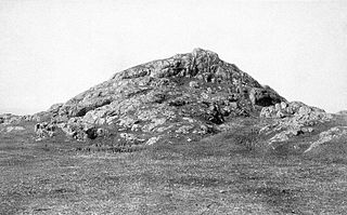
WThe Tap o' Noth is a hill and fort, 8 miles south of Huntly in Aberdeenshire, Scotland at grid reference NJ485293. It is the second highest fort in Scotland and its main feature is its well-preserved vitrified wall which encloses an area of approximately 100 m by 30 m, 0.3 hectares. Archaeological finds from the site include a stone axe head dated to between c. 2000 BC– c.800 BC, and a decorated bronze rein-ring dated to the 1st–3rd century AD. The site has been designated a scheduled ancient monument.
 W
WTorr a'Chaisteal is an Iron Age fort (dun), located about 1 mile northeast of the village of Sliddery, on the Isle of Arran in Scotland.
 W
WTraprain Law is a hill 6 km (4 mi) east of Haddington, East Lothian, Scotland, It is the site of a hill fort or possibly "oppidum", which covered at its maximum extent about 16 ha. It is the site of the Traprain Law Treasure, the largest Roman silver hoard from anywhere outside the Roman Empire which included exquisite silver artefacts.
WTrusty's Hill is a small vitrified hillfort about a mile to the west of the present-day town of Gatehouse of Fleet, in the parish of Anwoth in the Stewartry district of Dumfries and Galloway.
 W
WWhite Meldon is a prehistoric site, a hillfort near the village of Lyne and about 4 miles (6 km) west of Peebles, in the Scottish Borders, Scotland. It is a Scheduled Monument.