 W
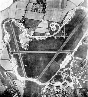
WRoyal Air Force Attlebridge or more simply RAF Attlebridge is a former Royal Air Force station located near Attlebridge and 8 miles (13 km) northwest of Norwich, Norfolk, England.
 W
WRAF Bacton is a former Royal Air Force landing field, built to accommodate aircraft intercepting Zeppelin bombers during the First World War.
WRAF Barton Bendish was an airfield for the Royal Air Force located on the far side of the Downham Market to Swaffham road from its parent station, RAF Marham. It was built because at the outbreak of the Second World War it was considered important for bomber stations to have a satellite airfield. The only aircraft known to have operated out of Barton Bendish were Vickers Wellington bombers from Marham. It was abandoned in 1942, as it was considered too close to the parent station to be developed further.No. 26 Squadron RAF. No. 268 Squadron RAF.
WRoyal Air Force Bircham Newton or more simply RAF Bircham Newton is a former Royal Air Force station located 2.1 miles (3.4 km) south east of Docking, Norfolk and 13.4 miles (21.6 km) north east of King's Lynn, Norfolk, England.
 W
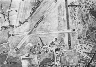
WRoyal Air Force Bodney or more simply RAF Bodney is a former Royal Air Force Station located 4.5 miles (7.2 km) west of Watton, Norfolk, England.
 W
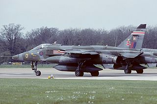
WRoyal Air Force Coltishall, more commonly known as RAF Coltishall, is a former Royal Air Force station located 10 miles (16 km) North-North-East of Norwich, in the English county of Norfolk, East Anglia, which operated from 1938 to 2006.
 W
WRoyal Air Force Deopham Green or more simply RAF Deopham Green is a former Royal Air Force station located near Deopham Green 2 miles (3.2 km) north of Attleborough, Norfolk, England.
WRoyal Air Force Docking or more simply RAF Docking is a former Royal Air Force station a few miles from Bircham Newton in Norfolk, England.
WRAF Downham Market was a Royal Air Force station in the west of the county of Norfolk in the United Kingdom which operated during the second half of the Second World War.
 W
WRoyal Air Force East Wretham or more simply RAF East Wretham is a former Royal Air Force station located 6 miles (9.7 km) northeast of Thetford, Norfolk, England.
 W
WRoyal Air Force Feltwell or more simply RAF Feltwell is a Royal Air Force station in Norfolk, East Anglia that is used by the United States Air Forces in Europe – Air Forces Africa. The station is located about 10 miles west of Thetford, and is in the borough of King's Lynn and West Norfolk at approximate Ordnance Survey grid reference TL 715 900.
WRoyal Air Force Foulsham, more commonly known as RAF Foulsham is a former Royal Air Force station, a military airfield, located 15 miles North-West of Norwich, in the English county of Norfolk, East Anglia, from 1942 to 1945.
WRoyal Air Force Great Massingham or more simply RAF Great Massingham is a former Royal Air Force station located 8.1 miles (13.0 km) southwest of Fakenham, Norfolk and 11.7 miles (18.8 km) east of King's Lynn, Norfolk, England.
 W
WRoyal Air Force Hardwick or more simply RAF Hardwick is a former Royal Air Force station located between the Norfolk villages of Topcroft and Hardwick in England. It is around 5 miles (8.0 km) west of Bungay, Suffolk.
 W
WRoyal Air Force Hethel or more simply RAF Hethel is a former Royal Air Force station which was used by both the United States Army Air Forces (USAAF) and the Royal Air Force (RAF) during the Second World War. The airfield is located 7 miles (11 km) south west of Norwich, Norfolk, England and is now owned by Lotus Cars.
 W
WRAF Horsham St Faith is a former Royal Air Force station near Norwich, Norfolk, England which was operational from 1939 to 1963. It was then developed as Norwich International Airport.
 W
WRoyal Air Force Langham or more simply RAF Langham is a former Royal Air Force station, located at Langham, 27.2 miles (43.8 km) northwest of Norwich in the English county of Norfolk. It operated between 1940 and 1961. The airfield was the most northerly of the wartime RAF airfields in Norfolk and its position, just 3.3 miles (5.3 km) from the North Sea at Blakeney, made it a suitable site for RAF Coastal Command aircraft.
 W
WRoyal Air Force Little Snoring or more simply RAF Little Snoring is a former Royal Air Force station located north of the Norfolk village of Little Snoring. The airfield remains open for general aviation use as Little Snoring Airfield.
WRoyal Air Force Ludham or more simply RAF Ludham is a former Royal Air Force station located near the village of Ludham, Norfolk.
 W
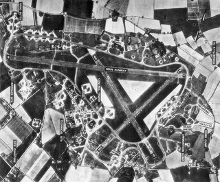
WRAF Marham is a Royal Air Force station and military airbase near the village of Marham in the English county of Norfolk, East Anglia.
 W
WRAF Matlaske was a satellite airfield of the Royal Air Force to RAF Coltishall, situated near Matlaske in Norfolk, England.
WRAF Mattishall is a former Royal Flying Corps landing ground located 1 mile (1.6 km) east of Mattishall, Norfolk and 10.2 miles (16.4 km) north west of Norwich, Norfolk, England.
 W
WRoyal Air Force Methwold or more simply RAF Methwold is a Royal Air Force station located 2.1 miles (3.4 km) north east of Feltwell, Norfolk and 10.9 miles (17.5 km) north west of Thetford, Norfolk, England.
 W
WThe area of Norwich between the Salhouse and Plumstead roads was originally the Cavalry Training Ground and then became the Royal Flying Corps Mousehold Heath aerodrome where Boulton Paul, among other manufacturers, passed over the aircraft they made for service. It was sometimes known as Norwich aerodrome by the Royal Flying Corps before it became Royal Air Force Mousehold Heath in April 1918.
WRAF Narborough was a military aerodrome in Norfolk operated in the First World War. It opened on 28 May 1915, originally as a Royal Naval Air Station for RNAS Great Yarmouth tasked with defending against Zeppelin raids. The airfield covered a 908-acre (3.67 km2) site, including 30 acres (120,000 m2) of buildings - making it the largest First World War airfield in Britain. These buildings included seven large hangars, seven sheds, five workshops, two coal yards, two Sergeant’s Messes, three Dope sheds and a Guardroom.
 W
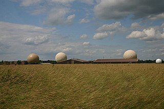
WRemote Radar Head Neatishead or RRH Neatishead is an air defence radar station operated by the Royal Air Force. It is located approximately 11 kilometres (6.8 mi) north east of Norwich in Norfolk, England.
WRoyal Air Force North Creake or more simply RAF North Creake is a former Royal Air Force station located 3.3 miles (5.3 km) southwest of Wells-next-the-Sea, Norfolk and 5.7 miles (9.2 km) northwest of Fakenham, Norfolk, England.
 W
WRoyal Air Force North Pickenham or more simply RAF North Pickenham is a former Royal Air Force station located 3 miles (4.8 km) East of Swaffham, Norfolk, England.
 W
WRoyal Air Force Old Buckenham is a former Royal Air Force station located 2 miles (3.2 km) south east of Attleborough, Norfolk, England which was used during the Second World War by the United States for the strategic bombing campaign against Germany.
 W
WRoyal Air Force Oulton or more simply RAF Oulton is a former Royal Air Force satellite airfield located 3 miles (4.8 km) west of Aylsham, Norfolk and 12.5 miles (20.1 km) northwest of Norwich, Norfolk, England.
 W
WRNAS Pulham was a Royal Navy Air Service (RNAS) airship station, near Pulham St Mary 18 mi (29 km) south of Norwich, UK. Though land was purchased by the Admiralty in 1912 the site was not operational until 1915. From 1918 to 1958, the unit was a Royal Air Force establishment. The land today is in private ownership, and little remains above ground. However, the Pennoyer Centre in Pulham St Mary holds an extensive archive of photographs and memorabilia relating to the Air Station.
 W
WRoyal Air Force Rackheath or more simply RAF Rackheath is a former Royal Air Force station located near the village of Rackheath, approximately 6 miles (9.7 km) north-east of Norwich, England.
 W
WSculthorpe Training Area, previously RAF Sculthorpe is a training site owned by the UK Ministry of Defence. It is about 3 mi (4.8 km) west of Fakenham in Norfolk, England. It forms part of the Defence Training Estate.
WRAF Sedgeford was a Royal Air Force airfield, located in the East of England county of Norfolk, East Anglia.
 W
WRoyal Air Force Seething or more simply RAF Seething is a former Royal Air Force station located 9 miles (14 km) south east of Norwich, Norfolk, England, just south of the village of Seething.
 W
WRoyal Air Force Shipdham or more simply RAF Shipdham is a former Royal Air Force station located 3 miles south of Dereham, Norfolk, England.
 W
WRoyal Air Force Snetterton Heath or more simply RAF Snetterton Heath is a former Royal Air Force station located south east of the A11, 6 miles (9.7 km) south west of Attleborough, Norfolk, England.
WRoyal Air Force Swannington, or more simply RAF Swannington, was a Royal Air Force station located 1.9 miles (3.1 km) south of Cawston and 9.3 miles (15.0 km) north west of Norwich in Norfolk, England.
 W
WThe former Royal Air Force Swanton Morley, more commonly known as RAF Swanton Morley, was a Royal Air Force station in Norfolk, England, located near to the village of Swanton Morley. The site is now occupied by the British Army, and is now known as Robertson Barracks.
 W
WRoyal Air Force Thorpe Abbotts or more simply RAF Thorpe Abbotts is a former Royal Air Force station located 4 miles (6.4 km) east of Diss, Norfolk, England.
 W
WRoyal Air Force Tibenham or more simply RAF Tibenham is a former Royal Air Force station located 13.5 miles (21.7 km) southwest of Norwich and 5.8 miles (9.3 km) north of Diss, Norfolk, England.
 W
WRemote Radar Head Trimingham or RRH Trimingham is a TPS-77 radar station situated on the coast in the English county of Norfolk. The site is located on the coast road between Cromer and Mundesley, 1 kilometre east of the village of Trimingham. The radar station is a satellite station of RAF Neatishead. This radar station is controlled and maintained by a section of Radar Technicians and Operators and supported by a team of Ground Engineers. Trimingham provides extensive coverage of the East coast of the United Kingdom and helps contribute to the recognised air picture and defence of the United Kingdom. The type 93 became operational on the site in April 1997.
 W
WRoyal Air Force Watton or more simply RAF Watton is a former Royal Air Force station located 9 mi (14 km) southwest of East Dereham, Norfolk, England.
 W
WRoyal Air Force Wendling or RAF Wendling is a former Royal Air Force station located 4 miles (6.4 km) north west of East Dereham, Norfolk, England.
WRoyal Air Force West Beckham or RAF West Beckham is a former Chain Home radar station controlled by the Royal Air Force located 3.8 miles (6.1 km) southeast of Holt, Norfolk and 5.3 miles (8.5 km) southwest of Cromer, Norfolk, England.
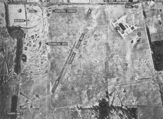
WRoyal Air Force West Raynham or more simply RAF West Raynham is a former Royal Air Force station located 2 miles (3.2 km) west of West Raynham, Norfolk and 5.5 miles (8.9 km) southwest of Fakenham, Norfolk, England.
 W
WRAF Weybourne was a Second World War anti-aircraft establishment. 'X' Flt, No 1 Anti-Aircraft Co-operation Unit were based at the station between 16 May and 14 September 1939, with 'T' Flt, No 1 Anti-Aircraft Co-operation Unit there between 25 February and 29 April 1942. No 6 Anti-Aircraft Co-operation Unit were based there between 7 December 1942 and 30 November 1943.