 W
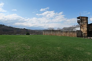
WFort Ashby is a historic stockade fort located in Fort Ashby, West Virginia, US. A military installation constructed during the French and Indian War, it is listed on the National Register of Historic Places.
 W
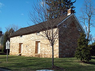
WAspen Hall, also known as the Edward Beeson House, was built beginning in 1771 as a stone house in the Georgian style in what would become Martinsburg, West Virginia. The first portion of the house was a 20 by 20 foot "fortified stone home", 2½ stories tall., in coursed rubble limestone built in 1745 by Edward Beeson I. It is the oldest house in Martinsburg.
 W
WFort Augusta was a stronghold in Northumberland County, Pennsylvania, in the upper Susquehanna Valley from the time of the French and Indian War to the close of the American Revolution.
 W
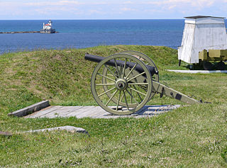
WThe Battlefields Park includes the Plains of Abraham with the nearby and smaller Des Braves park, both within the district of Montcalm in Quebec City, and forms one of the few Canadian national urban parks. Its significance lies in the Battle of the Plains of Abraham (1759) and the Battle of Sainte-Foy, fought six months later on today's Des Braves park.
 W
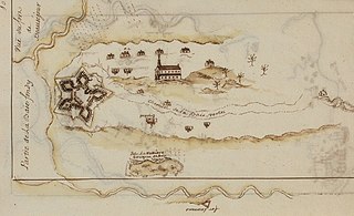
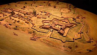
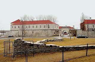
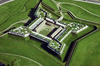
WFort Beauséjour, Fort Cumberland from 1755, is a large, five-bastioned fort on the Isthmus of Chignecto in eastern Canada, a neck of land connecting the present-day province of New Brunswick with that of Nova Scotia. The site was strategically important in Acadia, a French colony that included primarily the Maritimes, the eastern part of Quebec, and northern Maine of the later United States. The fort was built by the French from 1751 to 1752. They surrendered it to the British in 1755 after their defeat in the Battle of Fort Beauséjour, during the Seven Years' War. The British renamed the structure as Fort Cumberland. The fort was strategically important throughout the Anglo-French rivalry of 1749–63, known as the French and Indian Wars by British colonists. Less than a generation later, it was the site of the 1776 Battle of Fort Cumberland, when the British forces repulsed sympathisers of the American Revolution.
 W
WFort Boishébert is a National Historic Site of Canada located at modern-day Woodmans Point in the town of Grand Bay–Westfield, Kings County, New Brunswick, Canada. Located at the confluence of the Saint John River and Nerepis rivers, the fort may have had its origins as a fortified aboriginal village. Joseph Robineau de Villebon noted this in a letter dated October 22, 1696, "Sr. de Neuvillette reported that he was continuing on his way down river and would, as he passed the fort of the Nerepis Indians..." Earlier in October 1696, French soldiers upon being rescued by Nerepis, retreated to Fort Nerepis after being attacked by a small English fleet that had entered Saint John Harbour.
 W
WFort Carillon, the precursor of Fort Ticonderoga, was constructed by Pierre de Rigaud de Vaudreuil, Governor of French Canada, to protect Lake Champlain from a British invasion. Situated on the lake some 15 miles (24 km) south of Fort Saint Frédéric, it was built to prevent an attack on Canada and slow the advance of the enemy long enough for reinforcements to arrive.
 W
WFort Charlotte, Mobile is a partially-reconstructed 18th-century fort in Mobile, Alabama.
 W
WFort Chiswell is a census-designated place (CDP) in Wythe County, Virginia, United States. The population was 939 at the 2010 census.
 W
WFort Crown Point was a British fort built by the combined efforts of both British and provincial troops in North America in 1759 at a narrows on Lake Champlain on what later became the border between New York and Vermont. Erected to secure the region against the French, the fort is in upstate New York near the town of Crown Point and was the largest earthen fortress built in the United States. The fort's ruins, a National Historic Landmark, are now administered as part of Crown Point State Historic Site.
 W
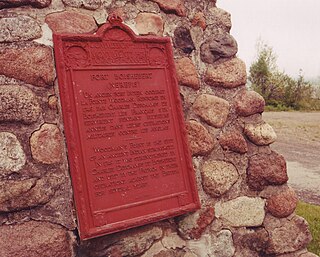
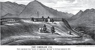
WFort Cumberland was an 18th-century frontier fort at the current site of Cumberland, Maryland, USA. It was an important military and economic center during the French and Indian War (1754–63) and figured significantly in the early career of George Washington.
WFort Depuy, located in Shawnee on Delaware, is a village in Smithfield Township. It was one of many forts in Colonial Pennsylvania built in 1755 and 1756 during the French and Indian War.
 W
WFort Deshler, located near Egypt, Lehigh County, Pennsylvania, was a French and Indian War era frontier fort established in 1760 to protect settlers from Indian attacks. The fort was near the location of what is now the intersection of Pennsylvania Route 145 and Chestnut Street, between Egypt and Coplay.
 W
WFort Dobbs was an 18th-century fort in the Yadkin–Pee Dee River Basin region of the Province of North Carolina, near what is now Statesville in Iredell County. Used for frontier defense during and after the French and Indian War, the fort was built to protect the American settlers of the western portion of what was then Rowan County, and served as a vital outpost for soldiers, traders, and colonial officials. Fort Dobbs' primary structure was a blockhouse with log walls, surrounded by a shallow ditch, and by 1761, a palisade. It was intended to provide protection from French-allied Native Americans such as the Shawnee and Delaware, and French raids into North Carolina.
 W
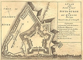
WFort Duquesne was a fort established by the French in 1754, at the confluence of the Allegheny and Monongahela rivers. It was later taken over by the English, and later Americans, and developed as Pittsburgh in the U.S. state of Pennsylvania. Fort Duquesne was destroyed by the French, prior to English conquest during the Seven Years' War, known as the French and Indian War on the North American front. The latter replaced it, building Fort Pitt between 1759 and 1761. The site of both forts is now occupied by Point State Park, where the outlines of the two forts have been laid in brick.
 W
WFort Edward is a National Historic Site of Canada in Windsor, Nova Scotia, and was built during Father Le Loutre's War (1749-1755). The British built the fort to help prevent the Acadian Exodus from the region. The Fort is most famous for the role it played both in the Expulsion of the Acadians (1755) and in protecting Halifax, Nova Scotia from a land assault in the American Revolution. While much of Fort Edward has been destroyed, including the officers' quarters and barracks, the blockhouse that remains is the oldest extant in North America. A cairn was later added to the site.
 W
WFort Sackville was a British fort in present-day Bedford, Nova Scotia. It was built during Father Le Loutre's War by British adjacent to present-day Scott Manor House, on a hill overlooking the Sackville River to help prevent French, Acadian and Mi'kmaq attacks on Halifax. The fort consisted of a blockhouse, a guard house, a barracks that housed 50 soldiers, and outbuildings, all encompassed by a palisade. Not far from the fort was a rifle range. The fort was named after George Germain, 1st Viscount Sackville.
 W
WFort Vieux Logis was a small British frontier fort built at present-day Hortonville, Nova Scotia, Canada in 1749, during Father Le Loutre's War (1749). Ranger John Gorham moved a blockhouse he erected in Annapolis Royal in 1744 to the site of Vieux Logis. The fort was in use until 1754. The British rebuilt the fort again during the French and Indian War and named it Fort Montague (1760).
 W
WThe Fort at Number 4 was a mid-18th century stockade fortification protecting Plantation Number 4, the northernmost British settlement along the Connecticut River in the Province of New Hampshire until after the French and Indian War. It was located in the present-day town of Charlestown, New Hampshire. A recreation of the fort, dating to 1960, now functions as an open-air museum, and was added to the New Hampshire State Register of Historic Places in July 2020.
 W
WFort Frontenac was a French trading post and military fort built in July 1673 at the mouth of the Cataraqui River where the St. Lawrence River leaves Lake Ontario, in a location traditionally known as Cataraqui. It is the present-day location of Kingston, Ontario, Canada. The original fort, a crude, wooden palisade structure, was called Fort Cataraqui but was later named for Louis de Buade de Frontenac, Governor of New France who was responsible for building the fort. It was abandoned and razed in 1689, then rebuilt in 1695.
 W
WFort Garrison, also known as Oulton's Garrison, Risteau's Garrison, and Olton's Garrison, is a historic fortification building located at Stevenson, Baltimore County, Maryland on Garrison Farms Court. It is a rectangular fieldstone building built about 1695. The fort was built to serve as a stronghold against attacks by Native Americans and was used during the French and Indian War. It is approximately 48 feet long and 18 feet wide with one large stone fireplace. Modifications in the early-19th century raised the height of the fort building adding a second story loft and a wood shingle roof. It was constructed following a 1693 order from Governor Francis Nicholson and his Council. The property was acquired in 1965 by the Baltimore County Department of Recreation and Parks.
 W
WFort George was a British colonial fort, erected in 1715 - 1737, that was located in Pejepscot (Brunswick), when Maine was under jurisdiction of the Province of Massachusetts Bay.
 W
WFort Granville was a militia stockade located in the colonial Province of Pennsylvania. Its site was about a mile from Lewistown, in what is now Granville Township, Mifflin County. Active from 1755 until 1756, the stockade briefly sheltered pioneer settlers in the Juniata River valley during the French and Indian War.
 W
WFort Halifax is a former British colonial outpost on the banks of the Sebasticook River, just above its mouth at the Kennebec River, in Winslow, Maine. Originally built as a wooden palisaded fort in 1754, during the French and Indian War, only a single blockhouse survives. The oldest blockhouse in the United States, it is preserved as Fort Halifax State Historic Site, and is open to the public in the warmer months. The fort guarded Wabanaki canoe routes that reached to the St. Lawrence and Penobscot Valleys via the Chaudière-Kennebec and Sebasticook-Souadabscook rivers. The blockhouse was declared a National Historic Landmark and added to the National Register of Historic Places in 1968.
 W
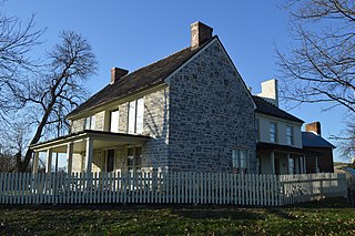
WDaniel Harrison House, also known as Fort Harrison, is a historic home located near Dayton, Rockingham County, Virginia. The original structure was built in 1748 as a two-story, three bay limestone dwelling, with a steep gable roof and wide chimney caps. A brick extension was added in the early 1800s. It was originally surrounded by a palisade and was reported to have an underground passage to the nearby spring. During the French and Indian War, the legislature of Virginia designated the house and surrounding property "Fort Harrison." The house is one of the oldest in the Shenandoah Valley, and is closely associated with the early history of Rockingham County.
 W
WFort Herkimer was a colonial fort located on the south side of the Mohawk River, opposite the mouth of its tributary West Canada Creek, in German Flatts, New York, United States.
 W
WFort Hyndshaw was a fort in Middle Smithfield Township, Monroe County, Pennsylvania, built in 1755 and 1756 during the French and Indian War.
 W
WOld Fort Johnson is a historic house museum and historic site at 2 Mergner Road in Fort Johnson, New York. It is the site of Fort Johnson, a two-story stone house originally enclosed in fortifications built by Sir William Johnson about 1749. The fort served as Johnson's home, business office and trading center until 1763 when he moved to Johnson Hall in what is now Johnstown, New York. Sir William's son Sir John Johnson owned the house from 1763 until 1776, when it was confiscated by the local Committee of Safety. The house remains and is owned and operated as a museum by the Montgomery County Historical Society. It was designated a National Historic Landmark in 1972.
 W
WLake George Battlefield Park Historic District is a national historic district relating to the French and Indian War Battle of Lake George and located near Lake George in Warren County, New York. The parkland was purchased and developed by New York State between 1896 and 1965. It encompasses numerous significant archaeological sites related to a series of conflicts dated from about 1755 to 1814. The archaeological sites include those related to Fort George (1759), earthen trenches (1757-1758), and barracks and hospitals dated to the 1750s. The historic districts also includes a number of plaques and monuments including those commemorating Henry Knox (1925), the Bloody Morning Scout (1935), Fr. Isaac Jogues (1939), King Hendrick Theyanoguin and General William Johnson. Other contributing features relate to the property's development as a park and include the battlefield park and battlefield campground, Fort George Road, the Delaware and Hudson Railway right of way, the Dowling Farmhouse, and the maintenance complex.
 W
WFort Le Boeuf was a fort established by the French during 1753 on a fork of French Creek, in present-day Waterford, in northwest Pennsylvania. The fort was part of a line that included Fort Presque Isle, Fort Machault, and Fort Duquesne.
 W
WFort Ligonier is a British fortification from the French and Indian War located in Ligonier, Pennsylvania, United States. The fort served as a staging area for the Forbes Expedition of 1758. During the eight years of its existence as a garrison, Fort Ligonier was never taken by an enemy. It served as a post of passage to the new Fort Pitt, and during Pontiac's War of 1763, was a vital link in the British communication and supply lines. It was attacked twice and besieged by the Native Americans, prior to the decisive victory at Bushy Run in August of that year. The fort was decommissioned from active service in 1766. Today, there is a museum next to the reconstructed fort. Inside the museum there are artifacts from the battle. An individual can take a guided tour of the fort, and on Fort Ligonier Days, the fort's cannons are fired.
WFort Loudoun was a fort in colonial Pennsylvania, one of several forts in colonial America named after John Campbell, 4th Earl of Loudoun. The fort was built in 1756 during the French and Indian War by the Second Battalion of the Pennsylvania Regiment under Colonel John Armstrong, and served as a post on the Forbes Road during the Forbes expedition that successfully drove the French away from Fort Duquesne.
 W
WFort Loudoun was a British fort located in what is now Monroe County, Tennessee. Constructed from 1756 until 1757 to help garner Cherokee support for the British at the outset of the French and Indian War, the fort was one of the first significant British outposts west of the Appalachian Mountains. The fort was designed by John William Gerard de Brahm, while its construction was supervised by Captain Raymond Demeré; the fort's garrison was commanded by Demeré's brother, Paul Demeré. It was named for the Earl of Loudoun, the commander of British forces in North America at the time.
 W
WFort Machault was a fort built by the French in 1754 near the confluence of French Creek with the Allegheny River, at present-day Franklin, in northwest Pennsylvania. The fort was part of a line that included Fort Presque Isle, Fort Le Boeuf, and Fort Duquesne.
WFort Necessity National Battlefield is a National Battlefield in Fayette County, Pennsylvania, United States, which preserves the site of the Battle of Fort Necessity. The battle, which took place on July 3, 1754, was an early battle of the French and Indian War, and resulted in the surrender of British colonial forces under Colonel George Washington, to the French and Indians, under Louis Coulon de Villiers.
 W
WFort Niagara is a fortification originally built to protect the interests of New France in North America. It is located near Youngstown, New York, on the eastern bank of the Niagara River at its mouth, on Lake Ontario.
 W
WNorridgewock was the name of both an Indigenous village and a band of the Abenaki Native Americans/First Nations, an Eastern Algonquian tribe of the United States and Canada. The French of New France called the village Kennebec. The tribe occupied an area in the interior of Maine. During colonial times, this area was territory disputed between British and French colonists, and was set along the claimed western border of Acadia, the western bank of the Kennebec River.
 W
WFort Ontario is an American historic bastion fort situated by the City of Oswego in Oswego County, New York. It is owned by the state of New York and operated as a museum known as Fort Ontario State Historic Site.
 W
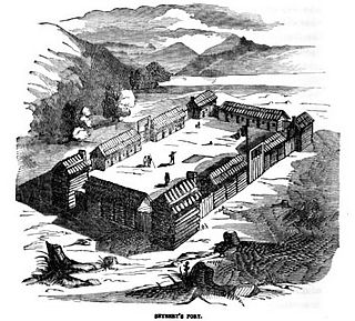
WFort Oswego was an 18th-century trading post in the Great Lakes region in North America, which became the site of a battle between French and British forces in 1756 during the French and Indian War. The fort was established in 1727 on the orders of New York governor William Burnet, adjacent to a 1722 blockhouse that had originally been a way station for French traders. The log palisade fort established a British presence on the Great Lakes.
 W
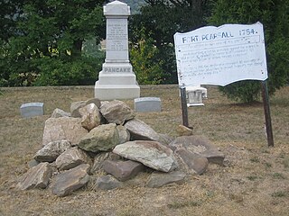
WFort Pearsall was an early frontier fort constructed in 1756 in Romney, West Virginia to protect local settlers in the South Branch Potomac River valley against Native American raids. The area around present-day Romney had been settled as early as 1725 by hunters and traders in the valley.
 W
WFort Pitt was a fort built by British forces between 1759 and 1761 during the French and Indian War at the confluence of the Monongahela and Allegheny rivers, where the Ohio River is formed in western Pennsylvania. It was near the site of Fort Duquesne, a French colonial fort built in 1754 as tensions increased between Great Britain and France in both Europe and North America. The French destroyed Fort Duquesne in 1758 when they retreated under British attack.
 W
WFort Presque Isle was a fort built by French soldiers in summer 1753 along Presque Isle Bay at present-day Erie, Pennsylvania, to protect the northern terminus of the Venango Path. It was the first of the French posts built in the Ohio Country, and was part of a line that included Fort Le Boeuf, Fort Machault, and Fort Duquesne.
 W
WFort Prince George was an uncompleted fort on what is now the site of Pittsburgh, at the confluence of the Allegheny and Monongahela Rivers in Allegheny County, Pennsylvania. The site was originally a trading post established by Ohio Company trader William Trent in the 1740s. Construction of Fort Prince George, named for the crown prince and later King George III), was begun in January 1754 by 41 Virginians. The plan to occupy the strategic forks was formed by Virginia Lieutenant Governor Robert Dinwiddie, on the advice of Lieutenant Colonel George Washington, whom Dinwiddie had sent on a mission to warn French commanders they were on English territory in late 1753, and had made a military assessment of the site. Captain Trent commanded the force constructing the fort, but his men were captured by 1,000 French soldiers and Indians led by Claude-Pierre Pécaudy de Contrecœur. At the time of the French arrival, Trent was at Wills Creek for a conference, while his second-in-command, Lieutenant John Fraser, was at his own plantation at Turtle Creek on the Mononghela River. Ensign Edward Ward was left to surrender the fort on April 18, 1754. The French attack was the hostile act of the war, and it led to George Washington's own surprise attack at the Battle of Jumonville Glen.
 W
WFort Schlosser was a fortification built in Western New York in the United States around 1760 by British Colonial forces, in order to guard the upper entrance to the portage around Niagara Falls, near the Porter-Barton Dock.
 W
WFort Seybert was an 18th-century frontier fort in the Allegheny Mountains in what is now Pendleton County, West Virginia, United States. In a 1758 surprise raid occasioned by the French and Indian War (1754–63), most of the 30 white settlers sheltering there were massacred by Shawnee and Delaware warriors and the fort was burned. A similar number of settlers at nearby Fort Upper Tract had met the same fate on the previous day. Fort Seybert, of which almost no trace remains today, was situated about 8 miles northeast of the present town of Franklin.
 W
WFort Stanwix was a colonial fortress whose construction commenced on August 26, 1758, under the direction of British General John Stanwix, at the location of present-day Rome, New York, but was not completed until about 1762. The bastion fort was built to guard a portage known as the Oneida Carry during the French and Indian War. Fort Stanwix National Monument, a reconstructed structure built by the National Park Service, now occupies the site.
 W
WFort Ticonderoga, formerly Fort Carillon, is a large 18th-century star fort built by the French at a narrows near the south end of Lake Champlain, in northern New York, in the United States. It was constructed by Canadian-born French military engineer Michel Chartier de Lotbinière, Marquis de Lotbinière between October 1755 and 1757, during the action in the "North American theater" of the Seven Years' War, often referred to in the US as the French and Indian War. The fort was of strategic importance during the 18th-century colonial conflicts between Great Britain and France, and again played an important role during the Revolutionary War.
 W
WFort Van Meter — or Fort VanMeter — is a mid-18th century frontier fort in the South Branch Potomac River Valley about 9 miles (14 km) southwest of Romney in Hampshire County, West Virginia, USA. It is located 15 miles (24 km) northeast of Moorefield and about a mile northeast of the former community of Glebe at the northern end of the rugged river gorge known as The Trough.
 W
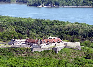
WFort William Henry was a British fort at the southern end of Lake George, in the province of New York. The fort's construction was ordered by Sir William Johnson in September 1755, during the French and Indian War, as a staging ground for attacks against the French position at Fort St. Frédéric. It was part of a chain of British and French forts along the important inland waterway from New York City to Montreal, and occupied a key forward location on the frontier between New York and New France. In 1757, the French general Louis-Joseph de Montcalm conducted a successful siege that forced the British to surrender. The Huron warriors who accompanied the French army subsequently killed many of the British prisoners. The siege and massacre were famously portrayed in James Fenimore Cooper's novel The Last of the Mohicans.