 W
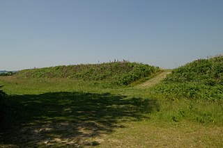
WBerry Camp or Berry Cliff, is an Iron Age Hill fort on a partially eroded cliff top close to Branscombe in Devon. The cliff is situated some 140 metres (460 ft) above sea level.
 W
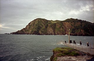
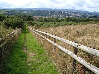
WBerry Head is a coastal headland that forms the southern boundary of Tor Bay in Devon, England. Lying to the east of the town of Brixham, it is a national nature reserve and a local nature reserve. Berry Head To Sharkham Point is a Site of Special Scientific Interest.
 W
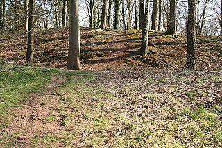
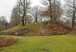
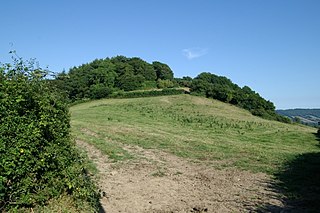
WBlackbury Camp is an Iron Age hill fort situated in Southleigh, Devon, England. The ramparts are still relatively high, showing an unusual entrance feature. The fort occupies the end of a large ridge at some 185 metres (607 ft) above sea level. It was defended by a single bank and ditch, forming a roughly D-shaped enclosure approximately 200 metres (660 ft) long and 100 metres (330 ft) wide. A triangular barbican was added to the south but was never completed. The fort was probably occupied in the 2nd and 1st centuries BC by a cattle-farming community.
 W
WThe Blackdown Rings are the earthworks of an Iron Age hill fort near the hamlet of Hazelwood in Devon, England. The fort is situated on a hilltop approximately 185 metres (607 ft) above sea level, in a commanding position above the River Avon.
 W
WBolt Tail is a headland in Devon, England, immediately to the southwest of Hope Cove in the South Hams district, at grid reference SX670397.
 W
WBoringdon Camp is an English Iron Age and Roman earthwork in Cann Woods, near Plympton, Plymouth, Devon. It is a scheduled ancient monument and owned by South Hams District Council.
 W
WBremridge Wood formerly part of the Domesday Book estate of Bremridge near South Molton, Devon, England, is the site of an Iron Age enclosure or hill fort. The earthwork is situated in woodland on a Hillside forming a promontory above the River Bray to the West of the Town at approx 175 Metres above Sea Level.
 W
WBrent Hill is the site of an Iron Age hill fort situated close to South Brent in Devon, England. The fort occupies the top of Brent Hill at approx 311 Metres above Sea Level.
 W
WBurley Wood is the site of an Iron Age hill fort north of Lydford in Devon, England. The fort occupies much of a hilltop some 220 metres above sea level overlooking the river Lew. The site also has a Norman motte-and-bailey earthwork just below it to the northeast at approx 215 metres above sea level.
 W
WBurridge Fort is an Iron Age Hill fort situated to the North East of Barnstaple in Devon, England. The fort occupies a hill top approx 150 Metres above Sea Level overlooking the Yeo and Bradiford rivers.
 W
WCadbury Castle is an Iron Age Hillfort close to Bickleigh, Devon, England. It was later encamped by the Parliamentarian forces during the English Civil War under Thomas Fairfax when he laid siege to Bickleigh Castle.
 W
WCapton is a village near Dartmouth in Devon, England.
 W
WCastle Close is a circular earthwork located near Stoodleigh in Mid Devon, England at OS grid reference SS937181. It is described on maps as a settlement. Situated some 208 metres above sea level, overlooking the River Exe, it is most likely to be an Iron Age Hill fort or enclosure.
 W
WCastle Dyke is an Iron Age hill fort situated between Chudleigh and Dawlish in Devon, England. The fort is situated on a Hilltop at approx 140 metres above sea level.
 W
WThere are two hills named Castle Hill within the immediate environs of Great Torrington in Devon, England. The first is within the town and is the site of the Norman & mediaeval castles, but was probably an Iron Age hill fort before this.50.9509°N 4.1436°W
 W
WCotley Castle is a large Iron Age Hill fort near Dunchideock in Devon and close to Exeter in England. It occupies a significant hilltop at 220 metres (720 ft) above sea level, just to the north of Great Haldon, part of the same ridge of the Haldon Hills.
 W
WCranbrook Castle is an Iron Age Hill fort occupying a commanding hilltop just to the south of and overlooking the Teign valley in Devon. It is 337 metres above sea level and 2 km south and slightly west of Prestonbury castle, 3 km west of Wooston Castle.
 W
WCranmore Castle is an Iron Age earthwork situated on a hillside above the Devon town of Tiverton in south-west England. Its National Grid reference is SS958118. It is an English Heritage scheduled monument, and has been given a National Monument number of 34256.
 W
WDenbury Hill is the name of an Iron Age hill fort near the village of Denbury in Devon, England.
 W
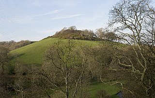
WDolbury is another local name for the Iron Age hill fort or enclosure at Killerton Park in Devon. It is referred to as such in several books and websites on Iron Age sites. The hill fort is situated on a hilltop some 128 Metres above Sea Level, the hilltop has a flat promontory jutting out northwards, still some 100 metres above sea level, around which the River Culm bends. The situation of the hill in the Culm Valley makes it very significant, although that can be hard to appreciate from the views afforded of it from the M5 motorway.
 W
WDumpdon Hill is an Iron Age Hill Fort near Honiton in Devon. Somewhat overshadowed by its better known neighbour Hembury Fort it is nonetheless as impressive an earthwork.
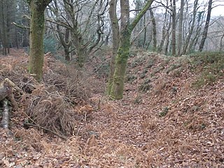
Embury Beacon is the site of an Iron Age promontory fort on the West of the Hartland Peninsula to the North of Bude and West of Clovelly in North Devon. The fort almost entirely been lost to coastal erosion, but a fraction of the Eastern Ramparts still exist at approx 150 Metres above Sea Level.
 W
WHalwell Camp is an Iron Age hill fort situated close to the village of Halwell in Devon, England. The fort is situated on a pass between two hilltops to the east of the village at approx 185 metres above sea level.
 W
WHawkesdown Hill is an Iron Age Hill fort close to Axmouth in Devon situated on a prominent hillside above the Axe Estuary. It is approximately 130 metres (430 ft) above sea level.
 W
WHembury is a Neolithic causewayed enclosure and Iron Age hill fort near Honiton in Devon. Its history stretches from the late fifth and early fourth millennia BC to the Roman invasion. The fort is situated on a south facing promontory at the end of a 240m high ridge in the Blackdown Hills. It lies to the north of and overlooking the River Otter valley and this location was probably chosen to give good views of the surrounding countryside as well as for defensive reasons.
 W
WHembury Castle is an Iron Age hillfort about a mile north-west of the village of Buckfast on the south-eastern edge of Dartmoor in Devon, England. The fort is about 178 metres above sea level on a promontory between the River Dart on the east and the Holy Brook, south-west. The slope down to the River Dart is very steep and is covered by Hembury Woods which is now a Site of Special Scientific Interest.
 W
WHigh Peak is a hill which is partially eroded, resulting in a cliff face, on the English Channel coast to the southwest of Sidmouth, Devon, southern England. Its highest point is about 157 metres (515 ft) above sea-level. It is a partially eroded Iron Age hill fort, with pre-Roman and post Roman pottery found there.
 W
WHillsborough is a local nature reserve in Ilfracombe, North Devon. It is known locally as the sleeping elephant. It was bought by the local council in the late nineteenth century to prevent development on the site. As well as a pleasant coastal area where visitors may roam, it includes the remains of an Iron Age hill fort.
 W
WHuntsham Castle, Devon, England is an Iron Age Hill fort enclosure near the village of Huntsham, it is located 260 m (850 ft) above sea level on the edge of the former Parish of Tiverton. The monument includes a slight univallate hillfort situated on a prominent hill overlooking the valleys of two separate tributaries to the River Lowman. The monument survives as a sub-circular enclosure, defining an area which slopes gently down to the south and measures approximately 150m in diameter. It is clearly demarcated on all sides by a rampart which varies in height from 1m up to 2.4m internally, being generally of greater height on the northern side of the enclosure. Externally this rampart is up to 2.9m high. Surrounding the rampart is an outer ditch which measures up to 5.4m wide and 0.4m deep and this is visible on all sides of the monument, although it is predominantly preserved as a buried feature. On the north eastern side, the outer edge of this ditch is defined by a field boundary bank and the infilled ditch has been used in the past as a track. There is an inturned entrance on the north eastern side which measures 7m wide, and the inturned banks are up to 2.2m wide and 0.4m high. The enclosure is crossed by a parish boundary bank which measures up to 2m wide and 1.5m high, and has been partially cut at the north eastern corner by a quarry, approximately 20m long, 15m wide and up to 2.8m deep, which lies to the north of the entrance. A further quarry lies to the south of the parish boundary bank, on the western side of the enclosure and measures 8.7 metres (29 ft) long, 5.3 metres (17 ft) wide and up to 1 metre (3.3 ft) deep. A third quarry lies to the north west and has partially cut into the ditch and rampart on this side; however much of this quarry lies just beyond the monument itself. A further entrance to the enclosure may lie on the western side, where the rampart is seen to kink slightly inwards. The stock proof fences around the rampart and ditch, the gates and gateposts which facilitate access, the Ordnance Survey triangulation point which is situated on the north eastern side of the enclosure just above the quarry, and the field boundary bank which defines the outer edge of the ditch in the north eastern corner are excluded from the scheduling, although the ground beneath all these features is included.
 W
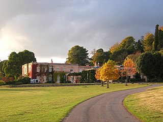
WKillerton is an 18th-century house in Broadclyst, Exeter, Devon, England, which, with its hillside garden and estate, has been owned by the National Trust since 1944 and is open to the public. The National Trust displays the house as a comfortable home. On display in the house is a collection of 18th- to 20th-century costumes, originally known as the Paulise de Bush collection, shown in period rooms.
 W
WKnowle Hill Castle is an Iron Age hill fort situated close to Braunton in Devon, England. The fort is situated on a hillside forming a promontory above the River Caen at approx 90 metres above sea level to the north of the town, close to the village of Knowle.
WLee Wood is the location of an Iron Age enclosure or hill fort situated near to Braunton and Barnstaple in Devon, England. The enclosure is situated on a sloping Hillside forming a promontory above the Knowle Water at approx 120 Metres above Sea Level to the north east of Braunton and north west of Barnstaple.
 W
WMembury Castle is an Iron Age Hill fort situated above the Village of Membury in Devon. The fort occupies a commanding hilltop position some 204 metres above sea level with views across both the Yarty & Axe Valleys.
 W
WMilber Down is an Iron Age hill fort on the hill above the suburb of Milber, Newton Abbot in Devon, England. The fort is situated on the north-western slope of Milber Down at about 110 metres above sea level, and is bisected by the minor ridge road that leads to Barton, Torquay. One Iron Age artefact discovered there was a figurine of a stag.
 W
WMusbury Castle is an Iron Age Hill fort situated above the Village of Musbury in Devon. The fort occupies a commanding hill top approx 175 Metres above Sea Level overlooking the Axe valleyat Ordnance Survey grid reference SY282941.
WPeppercombe is a small valley (combe) on the north-western coast of Devon, England. It is situated on the South West Coast Path between Westward Ho! to the north and Bucks Mills to the west. There is also a path descending from Horns Cross on the A39 road. The small stream of Peppercombe Water is a little over a kilometre long, but its valley is relatively deep. It ends in a waterfall consisting in a series of cascades, each between 0.5 and 1.5 metres high, that have formed due to the unequal hardness of the different beds of the underlying rock. The seaward section of Peppercombe is at the eastern end of the Hobby to Peppercombe biological Site of Special Scientific Interest (SSSI), while the coast section to north-east is part of the Mermaid's Pool to Rowden Gut geological SSSI.
 W
WPosbury is an ancient estate in Devon, now a hamlet, situated about 2 miles south-west of Crediton and 2 miles north of Tedburn St Mary and 1 mile west of the small hamlet of Venny Tedburn.
 W
WPrestonbury Castle is an Iron Age Hill fort on the north east edge of Dartmoor in Devon, England. Situated on a massive hilltop some 240 metres above sea level overlooking the Teign Valley, it is located near two other hill forts both of which lie about 2 km (1 mi) away.
 W
WRaddon Top is the highest point of the Raddon Hills, a small ridge of hills in the Shobrooke area of Mid Devon. The summit is at some 235 metres above sea level, making it a significant feature in the surrounding countryside.
 W
WRoborough Castle is an Iron Age enclosure or hill fort situated close to Lynton in Devon, England. The fort is situated on the North East edge of a Hillside forming a promontory above a tributary to the East Lyn River known as Hoaroak Water at approx 320 Metres above Sea Level.
 W
WShoulsbury Castle is an Iron Age hill fort close to Challacombe in Devon, England. It takes the form of a multi-ditch and rampart enclosure close to the top of a hill on the shoulder of Shoulsbarrow Common at an elevation of 472 metres (1,549 ft) above sea level.
 W
WSidbury Castle is a substantial Iron Age hill fort near Sidbury in Devon, England. It occupies a large hilltop overlooking the town and the River Sid at approximately 185 metres (607 ft) above sea level.
 W
WSlapton Castle is an Iron Age hill fort situated close to Slapton in Devon, England. The fort is on a promontory on the eastern side of a hilltop at approximately 65 metres (213 ft) above sea level, overlooking Slapton Ley.
 W
WStockland Castle is the name given to two Iron Age hill forts on Stockland Hill close to Stockland in Devon, England. Stockland Great Castle occupies a position on the eastern slope of the hill at 190–210 metres (620–690 ft) above sea level. Stockland Little Castle, located about 1 kilometre (0.6 mi) northeast of its larger neighbour, occupies a small promontory on the eastern slope of the hill at approximately 175 metres (574 ft) above sea level.
 W
WStoke Hill is a large hill rising to the north of Exeter in Devon, England. It is significant as the site of both an Iron Age hill fort and a later Roman signal station.
 W
WWind Hill, situated close to Lynmouth in Devon, England, is the location of an Iron Age enclosure or "spur" hill fort. The site is effectively a hillside forming a spur or promontory between the steep valley of the East Lyn River to the south and the cliffs to the north. Wind Hill's summit is at 261 metres (856 ft) above sea level, though the enormous earthworks defending the spur are at a lower level to the east.
 W
WWindbury Head is the site of an Iron Age hill fort on the Hartland Peninsula, just north of Clovelly in North Devon, England. Most of the fort has been lost to coastal erosion, but the southern ramparts still exist at approximately 100 metres (330 ft) above sea level.
 W
WWoodbury Castle is an Iron Age hillfort near the village of Woodbury in the English county of Devon, some eight miles southeast of the city of Exeter.
 W
WWooston Castle is an Iron Age Hill fort situated on the edge of a hill overlooking the Teign Valley in Devon some 200 metres above sea level, only 3 km south and east of Prestonbury Castle and 5 km east of Cranbrook Castle.