 W
WThe Bregenz Forest Mountains, also the Bregenzerwald Mountains, are a range of the Northern Limestone Alps, named after the town of Bregenz. The Bregenz Forest Mountains are entirely located in the Austrian state of Vorarlberg.
 W
WPiz Buin is a mountain in the Silvretta range of the Alps on the border between Austria and Switzerland. It forms the border between the Swiss canton of Graubünden and the Austrian state of Vorarlberg and is the highest peak in Vorarlberg.
 W
WPiz Buin Pitschen (Rumantsch) or Kleiner Piz Buin (German) is a peak in the Silvretta Alps. The Piz Buin Pitschen lies western of his higher neighbor the Piz Buin Grond or Großer Piz Buin.
 W
WThe Signalhorn is a mountain of the Silvretta Alps, located on the border between Switzerland and Austria. It lies just east of the Silvretta Pass and is the tripoint between the regions of Prättigau and Engadin and Montafon.
 W
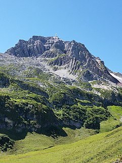
WDamülser Mittagsspitze is a 2,095 m (AA) high mountain in the Bregenz Forest Mountains in the Austrian state Vorarlberg.
 W
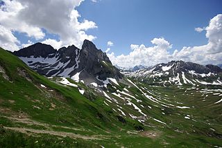
WThe Drei Türme are a group of peaks in the Rätikon range of the Alps, located on the border between Austria and Switzerland. The highest of the three, the Grosser Turm, lies on the Austrian side of the border, in the state of Vorarlberg. It is the highest point of the Drusenfluh group.
 W
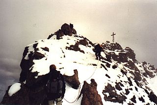
WThe Dreiländerspitze is one of the higher mountains in the Silvretta range in the eastern Alps, at 3,197 metres. The borders of Graubünden (Switzerland), Vorarlberg (Austria) and Tyrol (Austria) meet at the peak. Its name refers to a meeting point between the territories of three ancient tribes and their languages. It is also on the watershed between the Rhine and Danube. It is a favourite viewpoint, due to its position and accessibility. Its first documented ascent was by the German alpinist Theodor Petersen, accompanied by two locals, on 14 July 1870, although it appeared to have been previously climbed by surveyors in the 1850s. The nearest settlements are Galtür, 14 km to the north, and Guarda, 9 km to the south.
 W
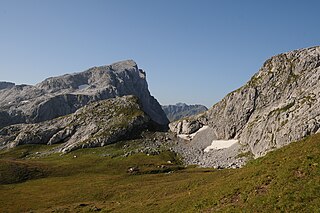
WThe Drusenfluh is a mountain in the Rätikon range of the Alps, located on the border between Austria and Switzerland. According to the Swisstopo map, the mountain both includes the 2827 m Drusenfluh on the border and the three peaks named the Drei Türme, the highest of which is north of the main ridge on the Austrian site. The Drusenfluh and Drei Türme are separated by the 2637 m Eisjöchl.
 W
WThe Fellhorn is a mountain in the "Allgäu Alps" near Oberstdorf, Germany, on the border with Austria. It is known for its fields of alpenroses. According to Austrian sources the mountain is 2,039 m above sea level (AA).
 W
WGalinakopf is a mountain on the border of Austria and Liechtenstein in the Rätikon range of the Eastern Alps, with a height of 2,198 metres (7,211 ft).
 W
WGamsgrat is a mountain on the border of Liechtenstein and Austria in the Rätikon range of the Eastern Alps close to the town of Malbun, with a height of 2,246 metres (7,369 ft).
 W
WThe Glatthorn in Vorarlberg in Austria is the highest mountain in the Bregenz Forest Mountains with a height of 2,133 m (AA). It lies west of and above the saddle of Faschinajoch, between Damüls to the north and Fontanella in the Großwalsertal to the south.
WGorfion is a mountain on the border of Austria and Liechtenstein in the Rätikon range of the Eastern Alps, with a height of 2,308 metres (7,572 ft).
 W
WThe Gross Litzner is a mountain in the Silvretta Alps, located on the border between Austria and Switzerland.
 W
WThe Gross Seehorn is a mountain of the Silvretta Alps, located on the border between Austria and Switzerland.
 W
WThe Great Walser Valley is located in the Austrian state of Vorarlberg. It is a side valley of the Walgau and stretches from there north to the mountainous center of the country. The end of the valley borders on the Bregenz Forest.
 W
WThe Hochmaderer is a prominent mountain, 2,823 metres high, in the Silvretta in the Austrian state of Vorarlberg, at the end of the Montafon valley. The multi-peaked block of primitive rock drops in mighty precipices to the south and east.
 W
WThe Hoher Ifen is a 2,230 metre high mountain in the Allgäu Alps, west of the Kleinwalsertal valley. In winter it forms the backdrop for a small ski area. It lies on the border between Germany and Austria. The summit is the highest point on the gently, tilted Ifen plateau.
 W
WIsentällispitz is a mountain of the Silvretta Alps, located on the border between Austria and Switzerland. The closest locality is Klosters on the Swiss side.
 W
WThe Kanisfluh is a mostly isolated massif in the central Bregenz Forest Mountains between the municipalities Mellau and Au.The Kanisfluh is considered the most famous mountain and landmark of the Bregenz Forest, Vorarlberg, Austria.
 W
WKanzelwand is a mountain on the border between Vorarlberg, Austria and Bavaria, Germany.
 W
WThe Karren is a mountain within the city bounds of Dornbirn, in Western Austria.
 W
WThe Kirchlispitzen is a mountain in the Rätikon range of the Alps, located on the border between Austria and Switzerland. It overlooks the Lünersee on its northern side.
 W
WThe Lechquellen Mountains or Lechquellen range is a small mountain group within the Northern Limestone Alps of the Eastern Alps. It lies entirely within the Austrian state of Vorarlberg and includes the upper reaches of the river Lech with its headstreams in a horseshoe shape as well as the Upper Großwalsertal valley.
WMaurerberg or Mauerer Berg is a mountain on the border of Liechtenstein and Austria in the Rätikon range of the Eastern Alps to the southeast of the town of Schaanwald, with a height of 1,378 metres (4,521 ft).
 W
WThe Mohnenfluh is a 2,544-metre-high mountain in the Austrian state of Vorarlberg.
 W
WThe Naafkopf is a mountain in the Rätikon range of the Alps, located at the border between Austria, Liechtenstein and Switzerland.
WOchsenkopf is a mountain on the border of Liechtenstein and Austria in the Rätikon range of the Eastern Alps close to the town of Malbun, with a height of 2,286 metres (7,500 ft).
 W
WThe Panüeler Kopf is a mountain in the Austrian state Vorarlberg. The Panüeler Kopf is part of the Schesaplana group and with an elevation of 2,859 m (AA) the second highest mountain in the Rätikon mountain range. The 950 m high west face is the highest rock face in the Rätikon.
 W
WThe Pfänder is a mountain in western Austria close to Lake Constance (Bodensee). The city of Bregenz lies at the foot of the mountain on the shores of the lake. With its views over the lake and the surrounding mountain peaks, the Pfänder is one of the most famous lookout points of the region.
 W
WThe Pflunspitzen are the highest points in the western Verwall Group in the Austrian Alps, reaching a maximum height of 2,912 m (AA). They lie west of the neighbouring Kaltenberg; the nearest village is Klösterle by Arlberg north of the peaks.
WRauher Berg is a mountain on the border of Liechtenstein and Austria in the Rätikon range of the Eastern Alps, close to the town of Malbun, with a height of 2,094 metres (6,870 ft).
 W
WThe Roggalspitze is a peak, 2,673 m (AA), in the Lechquellen Mountains, in the Austrian state of Vorarlberg. It is considered one of the most attractive climbing peaks in the range. The name of the mountain is derived from the Romansh word rocca, which means "rock" or "crag".
WThe Rotbüelspitz is a mountain of the Silvretta Alps, located on the border between Austria and Switzerland. It is located north of the slightly higher Isentällispitz.
 W
WThe Rote Wand is a mountain in the Lechquellen Mountains range of Vorarlberg, in western Austria.
 W
WSarojahöhe or Saroja is a mountain on the border of Liechtenstein and Austria in the Rätikon range of the Eastern Alps to the east of the village of Planken, with a height of 1,659 metres (5,443 ft).
WSattelköpfle is a mountain in on the border of Liechtenstein and Austria in the Rätikon range of the Eastern Alps to the east of the village of Planken, with a height of 1,688 metres (5,538 ft).
WScheienkopf is a mountain on the border of Liechtenstein and Austria, although the summit is in Austria, in the Rätikon range of the Eastern Alps with a height of 2,159 metres (7,083 ft).
 W
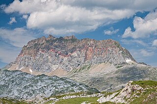
WThe Schesaplana is the highest mountain in the Rätikon mountain range at the border between Vorarlberg, Austria and Graubunden, Switzerland. It has an elevation of 2,964.3 m (9,725 ft).
 W
WThe Schijenflue is a mountain in the Rätikon range of the Alps, located on the border between Austria and Switzerland.
 W
WThe Silvrettahorn is a mountain of the Silvretta Alps, located on the border between Switzerland and Austria. On its southern Swiss side it overlooks the Silvretta Glacier.
 W
WThe Staufen is a 1465 metre high mountain in the very western part of Austria. The mountaintop splits the two bordering cities, Dornbirn and Hohenems. The Staufen is connected to the Karren, which belongs to the city of Dornbirn.
 W
WThe Sulzfluh is a mountain in the Rätikon range of the Alps, located on the border between Austria and Switzerland. The closest locality is St. Antönien, on the southern side.
 W
WTilisuna-Schwarzhorn is a 2,460 m (AA) in the Sulzfluh sub-range of the Rätikon mountain range in the Austrian state Vorarlberg. It has a long ridge from north to south and wide scarps east and west. Besides the main summit, there is a second summit called Kleines Schwarzhorn. Both summits are separated by the col Fürkele. The alpine club hut Tilisunahütte (2208 m) is located near the Tilisuna-Schwarzhorn.
 W
WThe Tschaggunser Mittagsspitze is a 2,168 m (AA) high mountain in the Rätikon mountain range of the Central Eastern Alps. It is located in the Austrian state Vorarlberg, south of the village Tschagguns in the Montafon valley.
 W
WValluga is a 2,809 m (AA) high mountain in the Lechtal Alps. The border between the Austrian states Tyrol and Vorarlberg runs over the summit. It is about 3 km north of the village St. Christoph am Arlberg and the Arlberg Pass.
 W
WVallüla is a mountain of the Silvretta Alps on the border between Tyrol and Vorarlberg, Austria. It is located above the Bielerhöhe pass, from where most climbs start from.
 W
WThe Großer Widderstein is a mountain, 2,533 m (AA), in the west Austrian state of Vorarlberg. Topographically it belongs to the Allgäu Alps. It is the highest peak in the subgroup of the Southeastern Walsertal Mountains.
 W
WThe Wildberg is a 2,788 m (AA) high mountain in the Schesaplana group of the Rätikon mountain range in the Austrian state Vorarlberg.
 W
WThe Untere Wildgrubenspitze is the highest peak of the Lechquellen Mountains in Austria. It reaches a height of 2,753 m above sea level (AA) and is located west of the ski resort of Zürs.
 W
WThe Wiss Platte is a mountain in the Rätikon range of the Alps, located on the border between Austria and Switzerland. It lies between Schruns (Vorarlberg) and St. Antönien (Graubünden).
WZigerbergkopf is a mountain on the border of Liechtenstein and Austria in the Rätikon range of the Eastern Alps with a height of 2,051 metres (6,729 ft).
 W
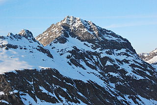
WThe Zimba, elevation 2,645 m (8,678 ft), is the most familiar mountain in the Austrian mountain range called Rätikon. Located in the hinterland of Bludenz, this horn is the landmark of Montafon valley and especially of the main village of Schruns. Three ridges and three walls emphasize the shapeliness of the form. The eastern ridge is one of the most familiar climbing routes of the whole Rätikon range, but the normal way leads along the western ridge. Despite the altitude of just 2,645 m, the Zimba is a great viewpoint for the entire region.