 W
WFlight instruments are the instruments in the cockpit of an aircraft that provide the pilot with data about the flight situation of that aircraft, such as altitude, airspeed, vertical speed, heading and much more other crucial information in flight. They improve safety by allowing the pilot to fly the aircraft in level flight, and make turns, without a reference outside the aircraft such as the horizon. Visual flight rules (VFR) require an airspeed indicator, an altimeter, and a compass or other suitable magnetic direction indicator. Instrument flight rules (IFR) additionally require a gyroscopic pitch-bank, direction and rate of turn indicator, plus a slip-skid indicator, adjustable altimeter, and a clock. Flight into instrument meteorological conditions (IMC) require radio navigation instruments for precise takeoffs and landings.
 W
WAn air data computer (ADC) is an essential avionics component found in modern aircraft. This computer, rather than individual instruments, can determine the calibrated airspeed, Mach number, altitude, and altitude trend data from an aircraft's pitot-static system. In some very high speed aircraft such as the Space Shuttle, equivalent airspeed is calculated instead of calibrated airspeed.
 W
WAn air data module is a component of the navigation system. Each unit converts pneumatic information from a pitot tube or a static port into numerical information which is sent on a data bus. This pressure information is received and processed by the Air Data Reference (ADR) component of the Air Data Inertial Reference Unit (ADIRU). This processed information is then sent to one or more display management computers that present information on the cockpit's primary flight display. Airspeed information is also sent to the flight computers and other electronics, including the autoflight subsystem.
 W
WIn aviation, ACARS is a digital datalink system for transmission of short messages between aircraft and ground stations via airband radio or satellite. The protocol was designed by ARINC and deployed in 1978, using the Telex format. More ACARS radio stations were added subsequently by SITA.
 W
WThe airspeed indicator (ASI) or airspeed gauge is a flight instrument indicating the airspeed of an aircraft in kilometers per hour (km/h), knots (kn), miles per hour (MPH) and/or meters per second (m/s). The recommendation by ICAO is to use km/h, however knots is currently the most used unit. The ASI measures the pressure differential between static pressure from the static port, and total pressure from the pitot tube. This difference in pressure is registered with the ASI pointer on the face of the instrument.
 W
WArea navigation is a method of instrument flight rules (IFR) navigation that allows an aircraft to choose any course within a network of navigation beacons, rather than navigate directly to and from the beacons. This can conserve flight distance, reduce congestion, and allow flights into airports without beacons. Area navigation used to be called "random navigation", hence the acronym RNAV.
 W
WThe attitude indicator (AI), formerly known as the gyro horizon or artificial horizon, is a flight instrument that informs the pilot of the aircraft orientation relative to Earth's horizon, and gives an immediate indication of the smallest orientation change. The miniature aircraft and horizon bar mimic the relationship of the aircraft relative to the actual horizon. It is a primary instrument for flight in instrument meteorological conditions.
 W
WAn automatic direction finder (ADF) is a marine or aircraft radio-navigation instrument that automatically and continuously displays the relative bearing from the ship or aircraft to a suitable radio station. ADF receivers are normally tuned to aviation or marine NDBs operating in the LW band between 190 – 535 kHz. Like RDF units, most ADF receivers can also receive medium wave (AM) broadcast stations, though as mentioned, these are less reliable for navigational purposes.
 W
WA non-directional (radio) beacon (NDB) is a radio transmitter at a known location, used as an aviation or marine navigational aid. As the name implies, the signal transmitted does not include inherent directional information, in contrast to other navigational aids such as low frequency radio range, VHF omnidirectional range (VOR) and TACAN. NDB signals follow the curvature of the Earth, so they can be received at much greater distances at lower altitudes, a major advantage over VOR. However, NDB signals are also affected more by atmospheric conditions, mountainous terrain, coastal refraction and electrical storms, particularly at long range.
 W
WAn autopilot is a system used to control the trajectory of an aircraft, marine craft or spacecraft without requiring constant manual control by a human operator. Autopilot does not replace human operators. Instead, autopilot assists the operator's control of the vehicle, allowing the operator to focus on broader aspects of operations.
 W
WAvidyne Entegra is an integrated aircraft instrumentation system, produced by Avidyne Corporation, consisting of a primary flight display (PFD), and multi-function display (MFD). Cirrus became the first customer of the Entegra system and began offering it on the SR20 and SR22 aircraft in 2003 as the first integrated flight deck for light general aviation (GA). The original Entegra system was designed to use third-party components such as a GPS from Garmin and an autopilot system from S-TEC Corporation.
 W
WAvionics are the electronic systems used on aircraft, artificial satellites, and spacecraft. Avionic systems include communications, navigation, the display and management of multiple systems, and the hundreds of systems that are fitted to aircraft to perform individual functions. These can be as simple as a searchlight for a police helicopter or as complicated as the tactical system for an airborne early warning platform. The term avionics is a portmanteau of the words aviation and electronics.
 W
WIn navigation, the course of a watercraft or aircraft is the cardinal direction in which the craft is to be steered. The course is to be distinguished from the heading, which is the compass direction in which the craft's bow or nose is pointed.
 W
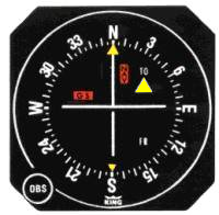
WA course deviation indicator (CDI) is an avionics instrument used in aircraft navigation to determine an aircraft's lateral position in relation to a course to or from a radio navigation beacon. If the location of the aircraft is to the left of this course, the needle deflects to the right, and vice versa.
 W
WDistance measuring equipment (DME) is a radio navigation technology that measures the slant range (distance) between an aircraft and a ground station by timing the propagation delay of radio signals in the frequency band between 960 and 1215 megahertz (MHz). Line-of-visibility between the aircraft and ground station is required. An interrogator (airborne) initiates an exchange by transmitting a pulse pair, on an assigned 'channel', to the transponder ground station. The channel assignment specifies the carrier frequency and the spacing between the pulses. After a known delay, the transponder replies by transmitting a pulse pair on a frequency that is offset from the interrogation frequency by 63 MHz and having specified separation.
 W
WThe Earth inductor compass is a compass that determines directions using the principle of electromagnetic induction, with the Earth's magnetic field acting as the induction field for an electric generator. The electrical output of the generator will vary depending on its orientation with respect to the Earth's magnetic field. This variation in the generated voltage is measured, allowing the Earth inductor compass to determine direction.
 W
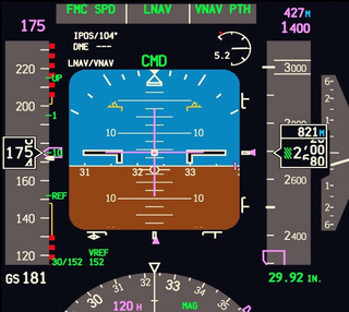
WAn electronic flight instrument system (EFIS) is a flight deck instrument display system that displays flight data electronically rather than electromechanically. An EFIS normally consists of a primary flight display (PFD), multi-function display (MFD), and an engine indicating and crew alerting system (EICAS) display. Early EFIS models used cathode ray tube (CRT) displays, but liquid crystal displays (LCD) are now more common. The complex electromechanical attitude director indicator (ADI) and horizontal situation indicator (HSI) were the first candidates for replacement by EFIS. Now, however, few flight deck instruments cannot be replaced by an electronic display.
 W
WAn engine-indicating and crew-alerting system (EICAS) is an integrated system used in modern aircraft to provide aircraft flight crew with instrumentation and crew annunciations for aircraft engines and other systems. On EICAS equipped aircraft the "recommended remedial action" is called a checklist.
 W
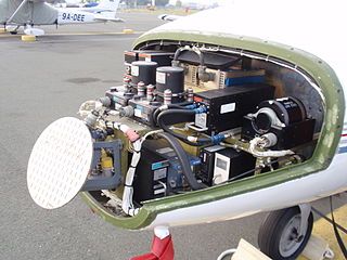
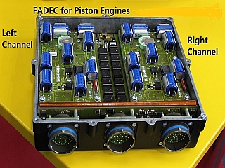
WA full authority digital engine control (FADEC) is a system consisting of a digital computer, called an "electronic engine controller" (EEC) or "engine control unit" (ECU), and its related accessories that control all aspects of aircraft engine performance. FADECs have been produced for both piston engines and jet engines.
 W
WFlight control mode or flight control law both refer to the computer software that transforms the movement of the joystick, made by an aircraft pilot, into movements of the aircraft control surfaces. The control surface movements depend on which of several modes the flight computer is in. In aircraft in which the flight control system is fly-by-wire, the movements the pilot makes to the joystick in the cockpit, to control the flight, are converted to electronic signals, which are transmitted to the flight control computers that determine how to move each control surface to provide the aircraft movement the pilot ordered.
 W
WA flight management system (FMS) is a fundamental component of a modern airliner's avionics. An FMS is a specialized computer system that automates a wide variety of in-flight tasks, reducing the workload on the flight crew to the point that modern civilian aircraft no longer carry flight engineers or navigators. A primary function is in-flight management of the flight plan. Using various sensors to determine the aircraft's position, the FMS can guide the aircraft along the flight plan. From the cockpit, the FMS is normally controlled through a Control Display Unit (CDU) which incorporates a small screen and keyboard or touchscreen. The FMS sends the flight plan for display to the Electronic Flight Instrument System (EFIS), Navigation Display (ND), or Multifunction Display (MFD). The FMS can be summarised as being a dual system consisting of the Flight Management Computer (FMC), CDU and a cross talk bus.
 W
WThe Garmin G1000 is an integrated flight instrument system typically composed of two display units, one serving as a primary flight display, and one as a multi-function display. Manufactured by Garmin, it serves as a replacement for most conventional flight instruments and avionics.
 W
WThe Garmin G3000 is an avionics system designed for light turbine aircraft. It is the first of its class to have an integrated touchscreen system, and it contains multiple glass cockpit displays, capable of operating a synthetic vision system, a three-dimensional displayed rendering of terrain. The G3000 was unveiled at the NBAA Convention in 2009.
WA glass cockpit is an aircraft cockpit that features electronic (digital) flight instrument displays, typically large LCD screens, rather than the traditional style of analog dials and gauges. While a traditional cockpit relies on numerous mechanical gauges to display information, a glass cockpit uses several multi-function displays driven by flight management systems, that can be adjusted to display flight information as needed. This simplifies aircraft operation and navigation and allows pilots to focus only on the most pertinent information. They are also popular with airline companies as they usually eliminate the need for a flight engineer, saving costs. In recent years the technology has also become widely available in small aircraft.
 W
WA Ground Proximity Warning System (GPWS) is a system designed to alert pilots if their aircraft is in immediate danger of flying into the ground or an obstacle. The United States Federal Aviation Administration (FAA) defines GPWS as a type of terrain awareness warning system (TAWS). More advanced systems, introduced in 1996, are known as enhanced ground proximity warning systems (EGPWS), a modern type of TAWS.
 W
WA gyrocompass is a type of non-magnetic compass which is based on a fast-spinning disc and the rotation of the Earth to find geographical direction automatically. The use of a gyrocompass is one of the seven fundamental ways to determine the heading of a vehicle. Although one important component of a gyrocompass is a gyroscope, these are not the same devices; a gyrocompass is built to use the effect of gyroscopic precession, which is a distinctive aspect of the general gyroscopic effect. Gyrocompasses are widely used for navigation on ships, because they have two significant advantages over magnetic compasses:they find true north as determined by the axis of the Earth's rotation, which is different from, and navigationally more useful than, magnetic north, and they are unaffected by ferromagnetic materials, such as in a ship's steel hull, which distort the magnetic field.
 W
WA head-up display or heads-up display, also known as a HUD, is any transparent display that presents data without requiring users to look away from their usual viewpoints. The origin of the name stems from a pilot being able to view information with the head positioned "up" and looking forward, instead of angled down looking at lower instruments. A HUD also has the advantage that the pilot's eyes do not need to refocus to view the outside after looking at the optically nearer instruments.
 W
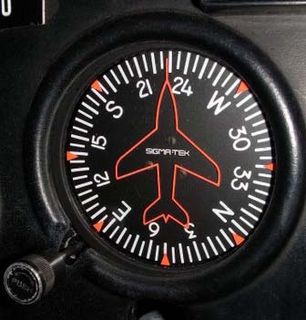
WThe heading indicator is a flight instrument used in an aircraft to inform the pilot of the aircraft's heading. It is sometimes referred to by its older names, the directional gyro or DG, and also direction indicator or DI.
 W
WThe Hemispherical Resonator Gyroscope (HRG), also called wine-glass gyroscope or mushroom gyro, is a compact, low noise, high performance angular rate or rotation sensor. An HRG is made using a thin solid-state hemispherical shell, anchored by a thick stem. This shell is driven to a flexural resonance by electrostatic forces generated by electrodes which are deposited directly onto separate fused-quartz structures that surround the shell. The gyroscopic effect is obtained from the inertial property of the flexural standing waves. Although the HRG is a mechanical system, it has no moving parts, and can be very compact.
 W
WHobbs meter is a genericized trademark for devices used in aviation to measure the time that an aircraft is in use. The meters typically display hours and tenths of an hour, but there are several ways in which the meter may be activated:It can measure the time that the electrical system is on. This maximizes the recorded time. It can be activated by oil pressure running into a pressure switch, and therefore runs while the engine is running. Many rental aircraft use this method to remove the incentive to fly with the master electrical switch off. It can be activated by another switch, either an airspeed sensing vane under a wing or a pressure switch attached to the landing gear. In these cases, the meter only measures the time the aircraft is actually flying. Metrics such as Time In Service and Turbine Actual Runtime are kept to monitor overhaul cycles, and are usually used by commercial operators under Federal Aviation Regulations Parts 135, 121, or 125. It can be activated when the engine alternators are online.
 W
WHoneywell Primus is a range of Electronic Flight Instrument System (EFIS) glass cockpits manufactured by Honeywell Aerospace. Each system is composed of multiple display units used as primary flight display and multi-function display.
 W
WThe horizontal situation indicator is an aircraft flight instrument normally mounted below the artificial horizon in place of a conventional heading indicator. It combines a heading indicator with a VHF omnidirectional range-instrument landing system (VOR-ILS) display. This reduces pilot workload by lessening the number of elements in the pilot's instrument scan to the six basic flight instruments. Among other advantages, the HSI offers freedom from the confusion of reverse sensing on an instrument landing system localizer back course approach. As long as the needle is set to the localizer front course, the instrument will indicate whether to fly left or right, in either direction of travel.
 W
WHOTAS, an acronym of hands on throttle-and-stick, is the concept of placing buttons and switches on the throttle lever and flight control stick in an aircraft's cockpit. By adopting such an arrangement, pilots are capable of performing all vital functions as well as flying the aircraft without having to remove their hands from the controls.
 W
WAn inertial measurement unit (IMU) is an electronic device that measures and reports a body's specific force, angular rate, and sometimes the orientation of the body, using a combination of accelerometers, gyroscopes, and sometimes magnetometers. IMUs are typically used to maneuver aircraft, including unmanned aerial vehicles (UAVs), among many others, and spacecraft, including satellites and landers. Recent developments allow for the production of IMU-enabled GPS devices. An IMU allows a GPS receiver to work when GPS-signals are unavailable, such as in tunnels, inside buildings, or when electronic interference is present. A wireless IMU is known as a WIMU.
 W
WAn inertial navigation system (INS) is a navigation device that uses a computer, motion sensors (accelerometers) and rotation sensors (gyroscopes) to continuously calculate by dead reckoning the position, the orientation, and the velocity of a moving object without the need for external references. Often the inertial sensors are supplemented by a barometric altimeter and occasionally by magnetic sensors (magnetometers) and/or speed measuring devices. INSs are used on mobile robots and on vehicles such as ships, aircraft, submarines, guided missiles, and spacecraft. Other terms used to refer to inertial navigation systems or closely related devices include inertial guidance system, inertial instrument, inertial measurement unit (IMU) and many other variations. Older INS systems generally used an inertial platform as their mounting point to the vehicle and the terms are sometimes considered synonymous.
 W
WAn inertial reference unit (IRU) is a type of inertial sensor which uses gyroscopes and accelerometers to determine a moving aircraft’s or spacecraft’s change in rotational attitude and translational position over a period of time. In other words, an IRU allows a device, whether airborne or submarine, to travel from one point to another without reference to external information. They mainly have application in guided missiles.
 W
WIn aviation, an instrument approach or instrument approach procedure (IAP) is a series of predetermined maneuvers for the orderly transfer of an aircraft under instrument flight conditions from the beginning of the initial approach to a landing or to a point from which a landing may be made visually. These approaches are approved in the European Union by EASA and the respective country authorities and in the United States by the FAA or the United States Department of Defense for the military. The ICAO defines an instrument approach as a series of predetermined maneuvers by reference to flight instruments with specific protection from obstacles from the initial approach fix, or where applicable, from the beginning of a defined arrival route to a point from which a landing can be completed and thereafter, if landing is not completed, to a position at which holding or enroute obstacle clearance criteria apply.
 W
WThe Intelligent Flight Control System (IFCS) is a next-generation flight control system designed to provide increased safety for the crew and passengers of aircraft as well as to optimize the aircraft performance under normal conditions. The main benefit of this system is that it will allow a pilot to control an aircraft even under failure conditions that would normally cause it to crash. The IFCS is being developed under the direction of the NASA Dryden Flight Research Center with the collaboration of the NASA Ames Research Center, Boeing Phantom Works, the Institute for Scientific Research at West Virginia University, and the Georgia Institute of Technology.
 W
WThe LN-3 inertial navigation system is an inertial navigation system (INS) that was developed in the 1960s by Litton Industries. It equipped the Lockheed F-104 Starfighter versions used as strike aircraft in European forces. An inertial navigation system is a system which continually determines the position of a vehicle from measurements made entirely within the vehicle using sensitive instruments. These instruments are accelerometers which detect and measure vehicle accelerations, and gyroscopes which act to hold the accelerometers in proper orientation.
 W
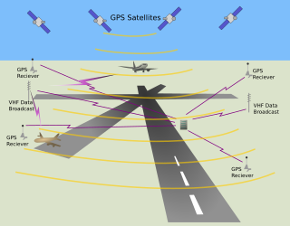
WThe local-area augmentation system (LAAS) is an all-weather aircraft landing system based on real-time differential correction of the GPS signal. Local reference receivers located around the airport send data to a central location at the airport. This data is used to formulate a correction message, which is then transmitted to users via a VHF Data Link. A receiver on an aircraft uses this information to correct GPS signals, which then provides a standard ILS-style display to use while flying a precision approach. The FAA has stopped using the term LAAS and has transitioned to the International Civil Aviation Organization (ICAO) terminology of Ground-Based Augmentation System (GBAS). While the FAA has indefinitely delayed plans for federal GBAS acquisition, the system can be purchased by airports and installed as a Non-Federal navigation aid.
 W
WLoran-C was a hyperbolic radio navigation system that allowed a receiver to determine its position by listening to low frequency radio signals transmitted by fixed land-based radio beacons. Loran-C combined two different techniques to provide a signal that was both long-range and highly accurate, features that had formerly been incompatible. The disadvantage was the expense of the equipment needed to interpret the signals, which meant that Loran-C was used primarily by militaries after it was first introduced in 1957.
 W
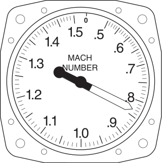
WA Machmeter is an aircraft pitot-static system flight instrument that shows the ratio of the true airspeed to the speed of sound, a dimensionless quantity called Mach number. This is shown on a Machmeter as a decimal fraction. An aircraft flying at the speed of sound is flying at a Mach number of one, expressed as Mach 1.
 W
WA multifunction display (MFD) is a small-screen surrounded by multiple soft keys that can be used to display information to the user in numerous configurable ways. MFDs originated in aviation, first in military aircraft, and later were adopted by commercial aircraft, general aviation, automotive use, and shipboard use.
 W
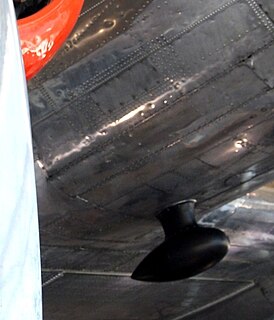
WA pitot tube, also known as pitot probe, is a flow measurement device used to measure fluid flow velocity. The pitot tube was invented by the French engineer Henri Pitot in the early 18th century and was modified to its modern form in the mid-19th century by French scientist Henry Darcy. It is widely used to determine the airspeed of an aircraft, water speed of a boat, and to measure liquid, air and gas flow velocities in certain industrial applications.
 W
WA pitot-static system is a system of pressure-sensitive instruments that is most often used in aviation to determine an aircraft's airspeed, Mach number, altitude, and altitude trend. A pitot-static system generally consists of a pitot tube, a static port, and the pitot-static instruments. Other instruments that might be connected are air data computers, flight data recorders, altitude encoders, cabin pressurization controllers, and various airspeed switches. Errors in pitot-static system readings can be extremely dangerous as the information obtained from the pitot static system, such as altitude, is potentially safety-critical. Several commercial airline disasters have been traced to a failure of the pitot-static system.
 W
WA primary flight display or PFD is a modern aircraft instrument dedicated to flight information. Much like multi-function displays, primary flight displays are built around a Liquid-crystal display or CRT display device. Representations of older six pack or "steam gauge" instruments are combined on one compact display, simplifying pilot workflow and streamlining cockpit layouts.
 W
WRadar is a detection system that uses radio waves to determine the range, angle, or velocity of objects. It can be used to detect aircraft, ships, spacecraft, guided missiles, motor vehicles, weather formations, and terrain. A radar system consists of a transmitter producing electromagnetic waves in the radio or microwaves domain, a transmitting antenna, a receiving antenna and a receiver and processor to determine properties of the object(s). Radio waves from the transmitter reflect off the object and return to the receiver, giving information about the object's location and speed.
 W
WRecon Instruments was a Canadian technology company that produced smartglasses and wearable displays marketed by the company as "heads-up displays" for sports. Recon's products delivered live activity metrics, GPS maps, and notifications directly to the user's eye. Recon's first heads-up display offering was released commercially in October 2010, roughly a year and a half before Google introduced Google Glass.
 W
WA satellite navigation or satnav system is a system that uses satellites to provide autonomous geo-spatial positioning. It allows small electronic receivers to determine their location to high precision using time signals transmitted along a line of sight by radio from satellites. The system can be used for providing position, navigation or for tracking the position of something fitted with a receiver. The signals also allow the electronic receiver to calculate the current local time to high precision, which allows time synchronisation. These uses are collectively known as Positioning, Navigation and Timing (PNT). Satnav systems operate independently of any telephonic or internet reception, though these technologies can enhance the usefulness of the positioning information generated.
 W
WSTRIL is short for "Stridsledning och Luftbevakning" which means "Combat control and air surveillance" in Swedish. STRIL 50 and STRIL 60 were integrated systems for aerial warfare control including early warning radar and ground-controlled interception. The systems depended on radar and radio as primary technologies but STRIL 50 was based on manual control while STRIL 60 applied the usage of early digital computers.
 W
WA tachometer is an instrument measuring the rotation speed of a shaft or disk, as in a motor or other machine. The device usually displays the revolutions per minute (RPM) on a calibrated analogue dial, but digital displays are increasingly common.
 W
WA tactical air navigation system, commonly referred to by the acronym TACAN, is a navigation system used by military aircraft. It provides the user with bearing and distance to a ground or ship-borne station. It is a more accurate version of the VOR/DME system that provides bearing and range information for civil aviation. The DME portion of the TACAN system is available for civil use; at VORTAC facilities where a VOR is combined with a TACAN, civil aircraft can receive VOR/DME readings. Aircraft equipped with TACAN avionics can use this system for en route navigation as well as non-precision approaches to landing fields. The space shuttle is one such vehicle that was designed to use TACAN navigation but later upgraded with GPS as a replacement.
 W
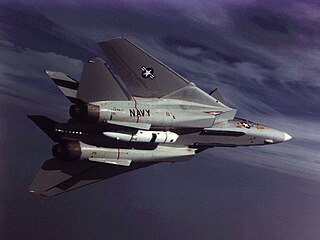
WThe Tactical Airborne Reconnaissance Pod System (TARPS) was a large and sophisticated camera pod carried by the Grumman F-14 Tomcat. It contains three camera bays with different type cameras which are pointed down at passing terrain. It was originally designed to provide an interim aerial reconnaissance capability until a dedicated F/A-18 Hornet reconnaissance version could be fielded. TARPS was pressed into service upon arrival in the fleet in 1981, and remained in use up to the end of Tomcat service in 2006.
 W
WIn aviation, the turn and slip indicator and the turn coordinator (TC) variant are essentially two aircraft flight instruments in one device. One indicates the rate of turn, or the rate of change in the aircraft's heading; the other part indicates whether the aircraft is in coordinated flight, showing the slip or skid of the turn. The slip indicator is actually an inclinometer that at rest displays the angle of the aircraft's transverse axis with respect to horizontal, and in motion displays this angle as modified by the acceleration of the aircraft. The most commonly used units are degrees per second (deg/s) or minutes per turn (min/tr).
 W
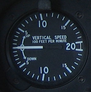
WA variometer – also known as a rate of climb and descent indicator (RCDI), rate-of-climb indicator, vertical speed indicator (VSI), or vertical velocity indicator (VVI) – is one of the flight instruments in an aircraft used to inform the pilot of the rate of descent or climb. It can be calibrated in metres per second, feet per minute or knots, depending on country and type of aircraft. It is typically connected to the aircraft's external static pressure source.
WVery high frequency omni-directional range (VOR) is a type of short-range radio navigation system for aircraft, enabling aircraft with a receiving unit to determine its position and stay on course by receiving radio signals transmitted by a network of fixed ground radio beacons. It uses frequencies in the very high frequency (VHF) band from 108.00 to 117.95 MHz. Developed in the United States beginning in 1937 and deployed by 1946, VOR is the standard air navigational system in the world, used by both commercial and general aviation. In the year 2000 there were about 3,000 VOR stations operating around the world including 1,033 in the US, reduced to 967 by 2013.
 W
WThe yaw string, also known as a slip string, is a simple device for indicating a slip or skid in an aircraft in flight. It performs the same function as the slip-skid indicator ball, but is more sensitive, and does not require the pilot to look down at the instrument panel. Technically, it measures sideslip angle, not yaw angle, but this indicates how the aircraft must be yawed to return the sideslip angle to zero.