 W
WTurn-by-turn Navigation is a feature of some GPS navigation devices where directions for a selected route are continually presented to the user in the form of spoken or visual instructions. The system keeps the user up-to-date about the best route to the destination, and is often updated according to changing factors such as traffic and road conditions. Turn-by-turn systems typically use an electronic voice to inform the user whether to turn left or right, the street name, and how much distance to the turn.
 W
WAllTrails is a fitness and travel mobile app used in outdoor recreational activities. AllTrails is commonly used for outdoor activities such as hiking, mountain biking, climbing and snow sports. The service allows users to access a database of trail maps, which includes crowdsourced reviews and images. Depending on a user's subscription status these resources can be used online and offline.
 W
WFind My Friends was a mobile phone tracking app and service for iOS devices developed by Apple Inc. It was replaced by the app Find My in 2019.
 W
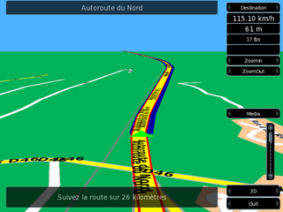
WThe iGO Navigation Engine, developed by Hungary-based NNG LLC is a GPS navigation software package. NNG sells some versions of the software directly to users, as well as to device manufacturers, auto makers, network operators and professional transport specialists. Products based on iGO are available in brands including Becker, Clarion, Pioneer, Samsung and Vodafone.
 W
WLife360 Inc. is a San Francisco–based information technology company that provides location-based services, including sharing and notifications, to consumers globally. Its main service is called Life360, a family social networking app released in 2008. It is a location-based service designed primarily to enable friends and family members to share their location with each other.
 W
WLocus Map is a multi-functional Android navigation app adding advanced online and offline GPS capabilities to Android devices. Primarily it is designed and used for leisure time outdoor activities like hiking, biking, geocaching. Besides its leisure time utilization the app is also used by professionals e.g. for collecting geospatial data, by rescue squad teams, aerial reconnaissance teams etc.
 W
WMaps.me is a mobile app for Android, iOS and BlackBerry that provides offline maps using OpenStreetMap data. It was formerly known as MapsWithMe. In November 2014, it was acquired by Mail.Ru Group and became part of its My.com brand. In September 2015, the app was open sourced. First, the whole team has developed an application in Belarus and Switzerland. Maps.me was founded by Yury Melnichek, Alexander Borsuk, Viktor Govako and Siarhei Rachytski. Under the leadership of Alexander, MapsWithMe got its first 2.5M users worldwide. Yury Melnichek was leading the project from November 2013 until April 2016 when Evgeny Lisovskiy took over. In early 2017 the philosophy of the app changed, leading it to be supported by unobtrusive adverts.
OsmAnd is a map and navigation app for Android and iOS. It uses the OpenStreetMap (OSM) map database for its primary displays, but is an independent app not endorsed by the OpenStreetMap Foundation. It is available in both free and paid versions; the latter unlocks the download limit for offline maps and provides access to Wikipedia points of interest (POIs) and their descriptions from within the app. Map data can be stored on the device for offline use. Using the device's GPS capabilities, OsmAnd offers routing, with visual and voice guidance, for car, bike, and pedestrian. All of the main functionalities work both online and offline.
 W
WTraccar is a free and open source GPS tracking server. As of 2019, Traccar claims to support more than 1,500 different models of GPS tracking devices.