 W
WA passenger information system or passenger information display system is an automated system for supplying users of public transport with information about the nature and state of a public transport service, through visual, voice or other media. They are also known as Customer Information Systems and Operational Information Systems. Among the information provided by such systems, a distinction can be drawn between:Static or schedule information, which changes only occasionally and is typically used for journey planning prior to departure. Real time information, derived from automatic vehicle location systems, which changes continuously as a result of real-world events and is typically used during the course of a journey.
 W
WAPTIS was the Accountancy and Passenger Ticket Issuing System used on the British Rail/National Rail until 2007. It was originally called "Advanced Passenger Ticket Issuing System" as it was being developed at the time of the Advanced Passenger Train.
 W
WA clock-face schedule or cyclic schedule is a timetable system under which public transport services run at consistent intervals, as opposed to a timetable that is purely driven by demand and has irregular headways. The name derives from the fact that departures take place at the same time or times during the day. For example, services with a half-hourly frequency might leave at 5:15, 5:45, 6:15, 6:45, 7:15, 7:45 etc.
 W
WA destination sign or destination indicator/destination blind is a sign mounted on the front, side or rear of a public transport vehicle, such as a bus, tram/streetcar or light rail vehicle, that displays the vehicle's route number and destination, or the route's number and name on transit systems using route names. The main such sign, mounted on the front of the vehicle, usually located above the windshield, is often called the headsign, most likely from the fact that these signs are located on the front, or head, end of the vehicle. Depending on the type of the sign, it might also display intermediate points on the current route, or a road that comprises a significant amount of the route, especially if the route is particularly long and its final terminus by itself is not very helpful in determining where the vehicle is going.
 W
WThe General Transit Feed Specification (GTFS) defines a common format for public transportation schedules and associated geographic information.
 W
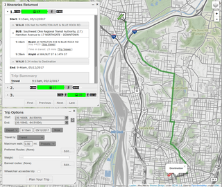
WA journey planner, trip planner, or route planner is a specialized search engine used to find an optimal means of travelling between two or more given locations, sometimes using more than one transport mode. Searches may be optimized on different criteria, for example fastest, shortest, fewest changes, cheapest. They may be constrained, for example, to leave or arrive at a certain time, to avoid certain waypoints, etc. A single journey may use a sequence of several modes of transport, meaning the system may know about public transport services as well as transport networks for private transportation. Trip planning or journey planning is sometimes distinguished from route planning, where route planning is typically thought of as using private modes of transportation such as cycling, driving, or walking, normally using a single mode at a time. Trip or journey planning, in contrast, would make use of at least one public transport mode which operates according to published schedules; given that public transport services only depart at specific times, an algorithm must therefore not only find a path to a destination, but seek to optimize it so as to minimize the waiting time incurred for each leg. In European Standards such as Transmodel, trip planning is used specifically to describe the planning of a route for a passenger, to avoid confusion with the completely separate process of planning the operational journeys to be made by public transport vehicles on which such trips are made.
 W
WMTA Bus Time, stylized as BusTime, is a Service Interface for Real Time Information, automatic vehicle location (AVL), and passenger information system provided by the Metropolitan Transportation Authority (MTA) of New York City for customers of its bus operations under the New York City Bus and MTA Bus Company brands. First tested in late 2010 and officially launched in early 2011, MTA Bus Time was installed in all MTA bus routes in New York City by 2014.
WA journey planner, trip planner, or route planner is a specialized search engine used to find an optimal means of travelling between two or more given locations, sometimes using more than one transport mode. Searches may be optimized on different criteria, for example fastest, shortest, fewest changes, cheapest. They may be constrained, for example, to leave or arrive at a certain time, to avoid certain waypoints, etc. A single journey may use a sequence of several modes of transport, meaning the system may know about public transport services as well as transport networks for private transportation. Trip planning or journey planning is sometimes distinguished from route planning, where route planning is typically thought of as using private modes of transportation such as cycling, driving, or walking, normally using a single mode at a time. Trip or journey planning, in contrast, would make use of at least one public transport mode which operates according to published schedules; given that public transport services only depart at specific times, an algorithm must therefore not only find a path to a destination, but seek to optimize it so as to minimize the waiting time incurred for each leg. In European Standards such as Transmodel, trip planning is used specifically to describe the planning of a route for a passenger, to avoid confusion with the completely separate process of planning the operational journeys to be made by public transport vehicles on which such trips are made.
 W
WA public transport timetable is a document setting out information on public transport service times, to assist passengers with planning a trip. Typically, the timetable will list the times when a service is scheduled to arrive at and depart from specified locations. It may show all movements at a particular location or all movements on a particular route or for a particular stop. Traditionally this information was provided in printed form, for example as a leaflet or poster. It is now also often available in a variety of electronic formats.
 W
WThe Atos Worldline FASTticket system is a passenger-operated, self-service railway ticket issuing system, developed by the Guildford-based company Shere Ltd and first introduced on a trial basis in Britain in 1996, shortly after privatisation. It has been developed and upgraded consistently since then, and is now used by seven Train Operating Companies (TOCs) as their primary self-service ticket issuing system. Other TOCs have FASTticket machines at some of their stations, sometimes supplementing other systems.
 W
WThe Shere SMART is a desktop-based railway ticket issuing system, developed by the Guildford-based company Shere Ltd, utilising Newbury Data ND4020 ticket printer, first introduced in Britain in 2003. Since the first trial installation of the system in the ticket office at London Bridge station, approximately 300 terminals have been installed at stations on the Southern and former Thameslink networks.
 W
WThe SMRT Active Route Map Information System is a rail travel information system developed in house by communications engineers from SMRT Corporation for its North South Line and East West Line (NSEWL) trains in Singapore. This system was officially announced on 7 November 2008 and firstly installed onboard a C151 train, set 053/054 for a 2-month trial. This was later extended to other trains from February 2009.
 W
WThe Transport Direct Portal was a distributed Internet-based multi-modal journey planner providing information for travel in England, Wales and Scotland. It was managed by Transport Direct, a division of the Department for Transport. It was launched in 2004 and was operated by a consortium led by Atos and later enhanced to include a cycle journey planning function. The closure of the portal was announced in September 2014 "Closure of the Transport Direct website" (PDF). Archived from the original (PDF) on 12 September 2014. and the portal closed on 30 September 2014.
 W
WTraveline is a public transport route planner service provided by a partnership between local authorities and transport operators in the UK to provide impartial and comprehensive information about public transport which has operated since 2000. It prepares comprehensive public transport data for the UK and provides a number of regional public transport journey planners.
 W
WTube, formerly called the Passenger Assist Railway Display System (PARDS), is a passenger information system currently deployed on certain lines of the Manila Light Rail Transit (LRT) and Metro Rail Transit (MRT) systems. Developed by Filipino technology companies TrackMate Business Solutions and PHAR Philippines, the system was initially unveiled on May 5, 2017.