 W
WCelestial navigation, also known as astronavigation, is the ancient and modern practice of position fixing that enables a navigator to transition through a space without having to rely on estimated calculations, or dead reckoning, to know their position. Celestial navigation uses "sights", or angular measurements taken between a celestial body and the visible horizon. The Sun is most commonly used, but navigators can also use the Moon, a planet, Polaris, or one of 57 other navigational stars whose coordinates are tabulated in the nautical almanac and air almanacs.
 W
WAn almucantar is a circle on the celestial sphere parallel to the horizon. Two stars that lie on the same almucantar have the same altitude.
 W
WThe Bris sextant is not a sextant proper, but is a small angle-measuring device that can be used for navigation. The Bris is, however, a true reflecting instrument which derives its high accuracy from the same principle of double reflection which is fundamental to the octant, the true sextant, and other reflecting instruments. It differs from other sextants primarily in being a fixed angle sextant, capable of measuring a few specific angles.
 W
WThe circle of equal altitude, also called circle of position (CoP), is the real line of position in celestial navigation. It is defined as the locus of points on Earth on which an observer sees a star, at a given time, with the same observed altitude. It was discovered by the American sea-captain Thomas Hubbard Sumner.
 W
WThe history of longitude is a record of the effort, by astronomers, cartographers and navigators over the centuries, to discover a means of determining longitude.
 W
WIn celestial navigation, lunar distance is the angular distance between the Moon and another celestial body. The lunar distances method uses this angle, also called a lunar, and a nautical almanac to calculate Greenwich time. That calculated time can be used in solving a spherical triangle. The method was published in 1763 and used until about 1850 when it was superseded by the marine chronometer. A similar method uses the positions of the Galilean moons of Jupiter.
WIn celestial navigation, lunar distance is the angular distance between the Moon and another celestial body. The lunar distances method uses this angle, also called a lunar, and a nautical almanac to calculate Greenwich time. That calculated time can be used in solving a spherical triangle. The method was published in 1763 and used until about 1850 when it was superseded by the marine chronometer. A similar method uses the positions of the Galilean moons of Jupiter.
 W
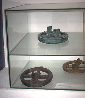
WThe mariner's astrolabe, also called sea astrolabe, was an inclinometer used to determine the latitude of a ship at sea by measuring the sun's noon altitude (declination) or the meridian altitude of a star of known declination. Not an astrolabe proper, the mariner's astrolabe was rather a graduated circle with an alidade used to measure vertical angles. They were designed to allow for their use on boats in rough water and/or in heavy winds, which astrolabes are ill-equipped to handle. In the sixteenth century, the instrument was also called a ring.
 W
WThe navigational algorithms are the quintessence of the executable software on portable calculators or PDA as an aid to the art of navigation, this attempt article describe both algorithms and software for "PC-PDA" implementing different calculation procedures for navigation . The calculation power obtained by the languages: Basic, "C", Java, etc. .., from portable calculators or PDAs, has made it possible to develop programs that allow calculating the position without the need for tables, in fact they have some basic tables with the correction factors for each year and calculate the values "on the fly" at runtime.
 W
WThe octant, also called reflecting quadrant, is a measuring instrument used primarily in navigation. It is a type of reflecting instrument.
 W
WA sextant is a doubly reflecting navigation instrument that measures the angular distance between two visible objects. The primary use of a sextant is to measure the angle between an astronomical object and the horizon for the purposes of celestial navigation.
 W
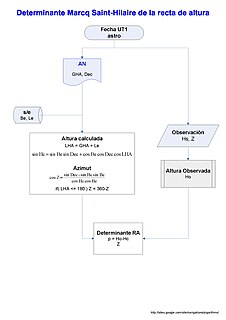
WIn navigation, sight reduction is the process of deriving from a sight,, the information needed for establishing a line of position.
 W
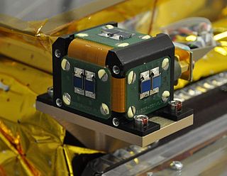
WA star tracker is an optical device that measures the positions of stars using photocells or a camera. As the positions of many stars have been measured by astronomers to a high degree of accuracy, a star tracker on a satellite or spacecraft may be used to determine the orientation of the spacecraft with respect to the stars. In order to do this, the star tracker must obtain an image of the stars, measure their apparent position in the reference frame of the spacecraft, and identify the stars so their position can be compared with their known absolute position from a star catalog. A star tracker may include a processor to identify stars by comparing the pattern of observed stars with the known pattern of stars in the sky.
WA star tracker is an optical device that measures the positions of stars using photocells or a camera. As the positions of many stars have been measured by astronomers to a high degree of accuracy, a star tracker on a satellite or spacecraft may be used to determine the orientation of the spacecraft with respect to the stars. In order to do this, the star tracker must obtain an image of the stars, measure their apparent position in the reference frame of the spacecraft, and identify the stars so their position can be compared with their known absolute position from a star catalog. A star tracker may include a processor to identify stars by comparing the pattern of observed stars with the known pattern of stars in the sky.
 W
WFifty-eight selected navigational stars are given a special status in the field of celestial navigation. Of the approximately 6,000 stars visible to the naked eye under optimal conditions, the selected stars are among the brightest and span 38 constellations of the celestial sphere from the declination of −70° to +89°. Many of the selected stars were named in antiquity by the Babylonians, Greeks, Romans, and Arabs.
 W
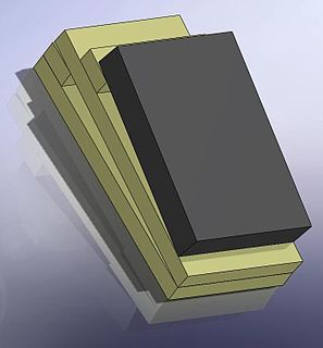
WA sun sensor is a navigational instrument used by spacecraft to detect the position of the sun. Sun sensors are used for attitude control, solar array pointing, gyro updating, and fail-safe recovery.