 W
WNorth America is a continent entirely within the Northern Hemisphere and almost all within the Western Hemisphere. It can also be described as the northern subcontinent of the Americas. It is bordered to the north by the Arctic Ocean, to the east by the Atlantic Ocean, to the southeast by South America and the Caribbean Sea, and to the west and south by the Pacific Ocean. However, Greenland, because it is on the North American Tectonic Plate, is included as part of North America geographically.
 W
WClassification of objects of the administrative-territorial system of Ukraine (KOATUU), is a national standardization system established by the State Committee of Ukraine for the Technical Regulations and Consumer Policy on October 31, 1997, #659, and went into effect on January 1, 1998.
 W
WCountry codes are short alphabetic or numeric geographical codes (geocodes) developed to represent countries and dependent areas, for use in data processing and communications. Several different systems have been developed to do this. The term country code frequently refers to ISO 3166-1 alpha-2 or international dialing codes, the E.164 country calling codes.
The Federal Geographic Data Committee (FGDC) is a United States government committee which promotes the coordinated development, use, sharing, and dissemination of geospatial data on a national basis. Its 32 members are representatives from the Executive Office of the President, and Cabinet level and independent Federal agencies. The Secretary of the Department of the Interior chairs the FGDC, with the Deputy Director for Management, Office of Management and Budget (OMB) as Vice-Chair.
 W
WThe geo URI scheme is a Uniform Resource Identifier (URI) scheme defined by the Internet Engineering Task Force's RFC 5870 as:a Uniform Resource Identifier (URI) for geographic locations using the 'geo' scheme name. A 'geo' URI identifies a physical location in a two- or three-dimensional coordinate reference system in a compact, simple, human-readable, and protocol-independent way.
The Geographic Names Information System (GNIS) is a database that contains name and locative information about more than two million physical and cultural features located throughout the United States of America and its territories. It is a type of gazetteer. GNIS was developed by the United States Geological Survey in cooperation with the United States Board on Geographic Names (BGN) to promote the standardization of feature names.
 W
WGeoNames is a user editable geographical database available and accessible through various web services, under a Creative Commons attribution license. The project was founded in late 2005.
 W
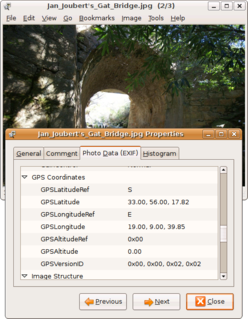
WGeotagging, or GeoTagging, is the process of adding geographical identification metadata to various media such as a geotagged photograph or video, websites, SMS messages, QR Codes or RSS feeds and is a form of geospatial metadata. This data usually consists of latitude and longitude coordinates, though they can also include altitude, bearing, distance, accuracy data, and place names, and perhaps a time stamp.
 W
WA grid reference system, also known as grid reference or grid system, is a geographic coordinate system that defines locations in maps using Cartesian coordinates based on a particular map projection. Grid lines on maps illustrate the underlying coordinate system. Such coordinate lines are numbered to provide a unique reference to each location on the map. Grid coordinates are normally eastings and northings.
 W
WThe ICAO airport code or location indicator is a four-letter code designating aerodromes around the world. These codes, as defined by the International Civil Aviation Organization and published in ICAO Document 7910: Location Indicators, are used by air traffic control and airline operations such as flight planning.
 W
WAn IATA airport code, also known as an IATA location identifier, IATA station code, or simply a location identifier, is a three-letter geocode designating many airports and metropolitan areas around the world, defined by the International Air Transport Association (IATA). The characters prominently displayed on baggage tags attached at airport check-in desks are an example of a way these codes are used.
 W
WThe International Map of the World or IMW was a project to create a complete map of the world according to internationally agreed standards. It was first proposed by the German geographer Albrecht Penck in 1891.
 W
WMarsden square mapping or Marsden squares is a system that divides a chart of the world with latitude-longitude gridlines between 80°N and 70°S latitudes into grid cells of 10° latitude by 10° longitude, each with a unique, numeric identifier. William Marsden, when first secretary of the Admiralty, conceived of this method for collecting and combining information respecting the oceans.
WThe Military Grid Reference System (MGRS) is the geocoordinate standard used by NATO militaries for locating points on Earth. The MGRS is derived from the Universal Transverse Mercator (UTM) grid system and the Universal Polar Stereographic (UPS) grid system, but uses a different labeling convention. The MGRS is used as geocode for the entire Earth.
 W
WThe oblique Mercator map projection is an adaptation of the standard Mercator projection. The oblique version is sometimes used in national mapping systems. When paired with a suitable geodetic datum, the oblique Mercator delivers high accuracy in zones less than a few degrees in arbitrary directional extent.
WThe Ordnance Survey National Grid reference system is a system of geographic grid references used in Great Britain, distinct from latitude and longitude.
 W
WIn geography, statistics and archaeology, a settlement, locality or populated place is a community in which people live. The complexity of a settlement can range from a small number of dwellings grouped together to the largest of cities with surrounding urbanized areas. Settlements may include hamlets, villages, towns and cities. A settlement may have known historical properties such as the date or era in which it was first settled, or first settled by particular people.
 W
WThe transverse Mercator map projection is an adaptation of the standard Mercator projection. The transverse version is widely used in national and international mapping systems around the world, including the Universal Transverse Mercator. When paired with a suitable geodetic datum, the transverse Mercator delivers high accuracy in zones less than a few degrees in east-west extent.
 W
WThe Unique Street Reference Number (USRN) is an eight-digit unique identifier for every street across Great Britain.
The United States Board on Geographic Names (BGN) is a federal body operating under the United States Secretary of the Interior. The purpose of the board is to establish and maintain uniform usage of geographic names throughout the federal government of the United States.
WThe United States National Grid (USNG) is a multi-purpose location system of grid references used in the United States. It provides a nationally consistent "language of location", optimized for local applications, in a compact, user friendly format. It is similar in design to the national grid reference systems used in other countries. The USNG was adopted as a national standard by the Federal Geographic Data Committee (FGDC) of the US Government in 2001.
 W
WWhat3words is a proprietary geocode system that is designed to identify any location with a resolution of about 3 metres (9.8 ft). What3words encodes geographic coordinates into three dictionary words; the encoding is permanently fixed. For example, the front door of 10 Downing Street in London is identified by ///slurs.this.shark. What3words differs from most other location encoding systems in that it displays three words rather than strings of numbers or letters which, it is suggested, significantly reduces the risk of transcription error.
 W
WA machine-readable passport (MRP) is a machine-readable travel document (MRTD) with the data on the identity page encoded in optical character recognition format. Many countries began to issue machine-readable travel documents in the 1980s.