 W
WA1 is a national highway in Kazakhstan that runs from Nur-Sultan to Petropavl with a total length of 456 kilometres (283 mi). It is part of the European route E125.
 W
WA2 is a national highway in Kazakhstan that runs from the border of Uzbekistan to the selo of Horgos with a total length of 1,292 kilometres (803 mi). It is part of the European route E40 and Asian Highway 5.
 W
WA3 is a national highway in Kazakhstan that runs from Almaty to Oskemen with a total length of 1,212 kilometres (753 mi).
 W
WAn agricultural road or farm track is a service road that serves predominantly agricultural or forestry purposes and has only local significance. Agricultural roads are typically unpaved dirt roads or covered with gravel, but in some cases asphalt roads are agricultural roads.
 W
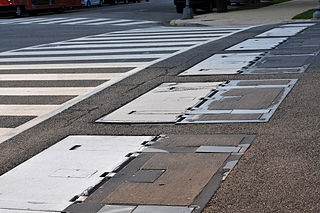
WBarrier boards are typically long plastic or wooden beams or metal plates used during road works and similar activities to cordon off areas, close roads or direct traffic.
 W
WThe bowtie is a type of road intersection which replaces left turns or right turns, with roundabouts on the cross street. It is an alternative to the Michigan left intersection.
 W
WA bus trap is a metal grate placed over a ditch or pit in the road with tines (sides) spaced far enough apart that small vehicles fall between the tines but close enough that larger-diameter-wheeled vehicles, such as buses, may pass. Cycles may cross broader sided examples.
 W
WChina National Highway 581 runs between Kashgar and Erkeshtam on the border with Kyrgyzstan. It is also known as the Sary-Tash-Ulugqat road and it was part of Asian Highway 65, although it is superceded by the G3013 Kashgar–Erkeshtam Expressway.
 W
WA dirt road or track is a type of unpaved road made from the native material of the land surface through which it passes, known to highway engineers as subgrade material. Dirt roads are suitable for vehicles; a narrower path for pedestrians, animals, and possibly small vehicles would be called a dirt track—the distinction is not well-defined. Unpaved roads with a harder surface made by the addition of material such as gravel and aggregate (stones), might be referred to as dirt roads in common usage but are distinguished as improved roads by highway engineers.
 W
WThe F-shape barrier is a concrete crash barrier, originally designed to divide lanes of traffic on a highway. It is a modification of the widely used Jersey barrier design, and is generally considered safer.
 W
WA floodway is a flood plain crossing for a road, built at or close to the natural ground level. It is similar to a causeway, but crosses a shallow depression that is subject to flooding, rather than a waterway or tidal water.
 W
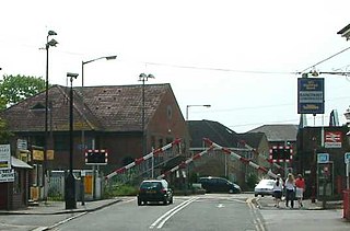
WA four-quadrant gate is a type of boom barrier gate protecting a grade crossing. It has a gate mechanism on both sides of the tracks for both directions of automotive traffic. The exit gates blocking the road leading away from the tracks in this application are equipped with a delay, and begin their descent to their horizontal position several seconds after the entrance gates do, so as to avoid trapping highway vehicles on the crossing. Many people consider four-quadrant gates to be safer than two-quadrant gates because they prevent drivers from illegally driving their vehicles around lowered gates to try to beat a train.
 W
WIn road and highway construction a gore is a triangular plot of land. A "virtual" gore is a triangular shaped space, characteristically marked off with distinguishing highway paint, often found leading to the unpaved area of a larger physical gore.
 W
WA half viaduct is a type of viaduct built into a hillside, where only part of the road is supported by the structure.
 W
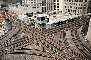
WA junction, when discussed in the context of transport, is a location where traffic can change between different routes, directions, or sometimes modes, of travel.
 W
WLoose chippings are loose gravel or stone fragments on a road surface and form a hazard to vehicles using that road. It may come from the road's chip seal. Causes include:Unbound surplus aggregate not removed from the surface when the road is resurfaced. Raveling of a chip seal or asphalt concrete pavement. This is usually the result of a poor bond between the asphalt and the aggregate. As a result, the aggregate breaks free from the road surface. Raveling caused by mechanical wear from snowplows or studded snow tires. Gravel deposited on the road by erosion of cut sections above the road. Gravel carried onto the road by tyres of a vehicle that was driven onto a gravel shoulder, or entered a paved road from a gravel road.
 W
WThe M1 is a 203 km long highway running across the Azeri coast. The route runs from the border of Russia to Baku. Near Baku the road is a motorway. The entire route is part of the European route E119 and Asian Highway AH8.
 W
WThe M7 is a 89 km (55 mi) long highway in Nakhchivan. The route runs northwest from the city of Nakhchivan to the border with Turkey in the northwestern end of the exclave. The route is one of three open border crossings in Nakhchivan and the only crossing with Turkey. The entire route is an undivided, four-lane highway, except for a short two-lane section crossing the Umut Bridge into Turkey.
 W
WThe M8 is a 89 km (55 mi) long highway in the Nakhchivan Autonomous Republic or Azerbaijan. It begins in the city of Nakhchivan and runs southeast to the closed border with Armenia. It is the primary highway in the southeast of the exclave. The road continues into Armenia as the E002 for 6.5 km (4.0 mi) until connecting to the M2 highway near Agarak.
 W
WThe Marshalite was a form of rotary traffic signal that was designed in 1936 by an Australian Charles Marshall, founder of the Fitzroy firm of Charles Marshall Pty. Ltd.
 W
WA military road is a type of road built by an armed force of a country which is usually responsible for its access, control, and maintenance.
 W
WMotorway is a typeface designed by Jock Kinneir and Margaret Calvert for use on the motorway network of the United Kingdom. Motorway was first used on the M6 Preston bypass in 1958 and has been in use on the UK's motorways ever since. The font is also used in some other countries, most notably Ireland and Portugal.
 W
WPoliScan speed is a system for traffic enforcement made by Vitronic. The measurement is based on lidar. By time-of-flight measurement, a scanning laser determines speeds and positions of all vehicles in the measurement area.
 W
WA primitive road is a minor road system, used for travel or transportation that is generally not maintained or paved.
 W
WPriority traffic signs indicate the order in which vehicles should pass intersection points. Vehicles often come into conflict with other vehicles and pedestrians because their intended courses of travel intersect, and thus interfere with each other's routes. The general principle that establishes who has the right to go first is called "right of way" or "priority". It establishes who has the right to use the conflicting part of the road and who has to wait until the other does so. The vehicle that does not need to wait is said to "have the right of way" or to "have priority."
 W
WProject Graham is a lifelike figure depicting what a human would look like if the species evolved to survive car accidents. Created as part of a road safety campaign for the Transport Accident Commission (TAC), it was meant to symbolise the vulnerability of human bodies in such accidents.
 W
WA refuge island, also known as a pedestrian refuge or pedestrian island, is a small section of pavement or sidewalk, completely surrounded by asphalt or other road materials, where pedestrians can stop before finishing crossing a road. It is typically used when a street is very wide, as the pedestrian crossing can be too long for some individuals to cross in one traffic light cycle. They may also be seen on roads with higher speed limits. In the United Kingdom, refuge islands are commonly illuminated by a white 300 mm beacon mounted on a 5 m grey pole with white reflective bands. In 2015, a solar powered version of the refuge Beacon was introduced, requiring no mains cabling and incorporating the energy saving technology cited in patent GB2519445.
 W
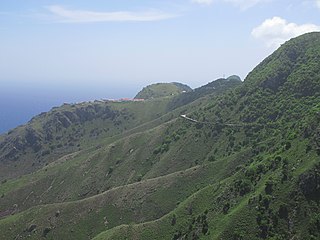
WThe Road is the unofficial name for the road that connects the villages of Saba, Netherlands, a Caribbean island. It is nicknamed as "The Road That Couldn't Be Built."
 W
WLaos traffic signs use Lao, the national language of Laos. However, English is also used for stop and important public places such as tourist attractions, airports, railway stations, and immigration checkpoints. Both Lao and English are used on directional signage.
 W
WA roadblock is a temporary installation set up to control or block traffic along a road. The reasons for one could be:Roadworks Temporary road closure during special events Police chase Robbery Sobriety checkpoint
 W
WRoadworks occur when part of the road, or in rare cases, the entire road, has to be occupied for work relating to the road, most often in the case of road surface repairs. In the United States road work could also mean any work conducted in close proximity of travel way (thoroughfare) such as utility work or work on power lines. The general term of road work is known as work zone.
 W
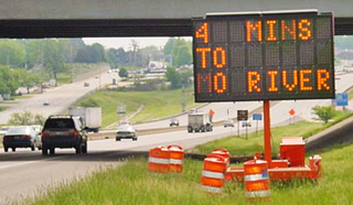
WA smart work zone or intelligent work zone refers to a site-specific configuration of traffic control technology deployed within a roadway work zone to increase the safety of construction workers, provide "real-time" travel information, and efficiently route motorists through a work zone. Smart work zones reduce the dependency on human "flaggers" and make the work zone safer for roadway workers.
 W
WIn Belize, the Southern Highway takes up where the Hummingbird Highway ends and runs from Dangriga to Punta Gorda. It is entirely paved, with the completion of a 10-mile segment between Golden Stream and Big Falls circa 2008–09. The Southern Highway provides important access to a number of Mayan ruins and natural areas. The ancient Mayan sites of Nim Li Punit and Lubaantun are each situated a few miles west of the highway in southern Belize. The Cockscomb Basin Wildlife Sanctuary is several miles west of the highway in south-central Belize.
 W
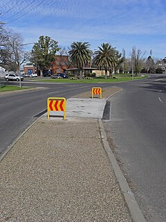
WA traffic island is a solid or painted object in a road that channels traffic. It can also be a narrow strip of island between roads that intersect at an acute angle. If the island uses road markings only, without raised curbs or other physical obstructions, it is called a painted island or ghost island. Traffic islands can be used to reduce the speed of cars driving through, or to provide a central refuge to pedestrians crossing the road.
 W
WA traffic tower is a permanent raised structure providing a clearer view of traffic conditions than can be had from street level and protection for the traffic controller from the hazards of moving vehicles.
 W
WTuckey's Lane is a lane of the old town of Gibraltar. It connects Line Wall Road to Main Street. The Italian Consulate and the Maharaja Indian Restaurant are located here as is Barclays Bank and Sacarello's restaurant on the corner with Main Street.
 W
WA two-way street is a street that allows vehicles to travel in both directions. On most two-way streets, especially main streets, a line is painted down the middle of the road to remind drivers to stay on their side of the road. Sometimes one portion of a street is two-way and the other portion is one-way. If there is no line, a car must stay on the appropriate side and watch for cars coming in the opposite direction and prepare to pull over to let them pass.
PIARC is an international forum for the discussion of all aspects of roads and road networks.