 W
WAn automatic direction finder (ADF) is a marine or aircraft radio-navigation instrument that automatically and continuously displays the relative bearing from the ship or aircraft to a suitable radio station. ADF receivers are normally tuned to aviation or marine NDBs operating in the LW band between 190 – 535 kHz. Like RDF units, most ADF receivers can also receive medium wave (AM) broadcast stations, though as mentioned, these are less reliable for navigational purposes.
 W
WThe automatic identification system (AIS) is an automatic tracking system that uses transceivers on ships and is used by vessel traffic services (VTS). When satellites are used to detect AIS signatures, the term Satellite-AIS (S-AIS) is used. AIS information supplements marine radar, which continues to be the primary method of collision avoidance for water transport. Although technically and operationally distinct, the ADS-B system is analogous to AIS and performs a similar function for aircraft.
 W
WCCGS Bartlett is a Provo Wallis-class buoy tender in operation by the Canadian Coast Guard. The vessel entered service in 1969 and was modernized in 1988. In 1982, the ship commanded the recovery efforts following the Ocean Ranger sinking off the coast of Newfoundland. The vessel is assigned to the Pacific Region and is based at Victoria, British Columbia.
Carlisle & Finch is a manufacturer of nautical equipment founded in 1893 or 1894 in Cincinnati, Ohio, where, as of 2021, it still has its headquarters. It is most recognized today for its searchlights and navigational lights, but is also known as a producer and innovator of electric toy trains in the early years of the company.
 W
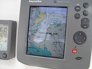
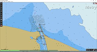
WA Chartplotter is a device used in marine navigation that integrates GPS data with an electronic navigational chart (ENC).
A day beacon is an unlighted nautical sea mark. A signboard attached to a day beacon is called a day mark and is used to identify it. Typically, day beacons mark channels whose key points are marked by lighted buoys. Day beacons may also mark smaller navigable routes in their entirety. They are the most common aid to nautical navigation in shallow water as they are relatively inexpensive to install and maintain. Navigation around day beacons is the same as with all other navigational aids.
 W
WA daymark or a day marker is the daytime identifier of an aid to navigation (ATON) or day beacon.
 W
WDistance measuring equipment (DME) is a radio navigation technology that measures the slant range (distance) between an aircraft and a ground station by timing the propagation delay of radio signals in the frequency band between 960 and 1215 megahertz (MHz). Line-of-visibility between the aircraft and ground station is required. An interrogator (airborne) initiates an exchange by transmitting a pulse pair, on an assigned 'channel', to the transponder ground station. The channel assignment specifies the carrier frequency and the spacing between the pulses. After a known delay, the transponder replies by transmitting a pulse pair on a frequency that is offset from the interrogation frequency by 63 MHz and having specified separation.
 W
WAn Electronic Chart Display and Information System (ECDIS) is a geographic information system used for nautical navigation that complies with International Maritime Organization (IMO) regulations as an alternative to paper nautical charts. IMO refers to similar systems not meeting the regulations as Electronic Chart Systems (ECSs).
WAn electronic navigational chart or ENC is an official database created by a national hydrographic office for use with an Electronic Chart Display and Information System (ECDIS). An electronic chart must conform to standards stated in the International Hydrographic Organization (IHO) Publication S-57 before it can be certified as an ENC. Only ENCs can be used within ECDIS to meet the International Maritime Organization (IMO) performance standard for ECDIS.
 W
WThe Fiddler's Reach Fog Signal is a fog signal station located on the Kennebec River in Arrowsic, Maine, in Sagadahoc County. It is about 1,100 feet (340 m) SW of the front light of the Doubling Point Range Lights, and about 2,000 feet (610 m) east of Doubling Point Light. The pyramidal bell structure was built in 1914, two years after a large steamship, the Ransom B. Fuller, ran aground in the fog on this section of the river.
 W
WA foghorn or fog signal is a device that uses sound to warn vehicles of navigational hazards such as rocky coastlines, or boats of the presence of other vessels, in foggy conditions. The term is most often used in relation to marine transport. When visual navigation aids such as lighthouses are obscured, foghorns provide an audible warning of rock outcrops, shoals, headlands, or other dangers to shipping.
 W
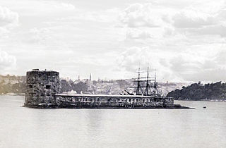
WFort Denison, part of the Sydney Harbour National Park, is a protected national park that is a heritage-listed former penal site and defensive facility occupying a small island located north-east of the Royal Botanic Gardens and approximately 1 kilometre (0.62 mi) east of the Opera House in Sydney Harbour, New South Wales, Australia. The island was formerly known in its indigenous name of Mat-te-wan-ye, and as Pinchgut Island.
 W
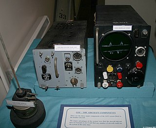
WGee, sometimes written GEE, was a radio navigation system used by the Royal Air Force during World War II. It measured the time delay between two radio signals to produce a fix, with accuracy on the order of a few hundred metres at ranges up to about 350 miles (560 km). It was the first hyperbolic navigation system to be used operationally, entering service with RAF Bomber Command in 1942.
 W
WThe Hemispherical Resonator Gyroscope (HRG), also called wine-glass gyroscope or mushroom gyro, is a compact, low noise, high performance angular rate or rotation sensor. An HRG is made using a thin solid-state hemispherical shell, anchored by a thick stem. This shell is driven to a flexural resonance by electrostatic forces generated by electrodes which are deposited directly onto separate fused-quartz structures that surround the shell. The gyroscopic effect is obtained from the inertial property of the flexural standing waves. Although the HRG is a mechanical system, it has no moving parts, and can be very compact.
 W
WAn inertial navigation system (INS) is a navigation device that uses a computer, motion sensors (accelerometers) and rotation sensors (gyroscopes) to continuously calculate by dead reckoning the position, the orientation, and the velocity of a moving object without the need for external references. Often the inertial sensors are supplemented by a barometric altimeter and occasionally by magnetic sensors (magnetometers) and/or speed measuring devices. INSs are used on mobile robots and on vehicles such as ships, aircraft, submarines, guided missiles, and spacecraft. Other terms used to refer to inertial navigation systems or closely related devices include inertial guidance system, inertial instrument, inertial measurement unit (IMU) and many other variations. Older INS systems generally used an inertial platform as their mounting point to the vehicle and the terms are sometimes considered synonymous.
 W
WIn aviation, the instrument landing system (ILS) is a radio navigation system that provides short-range guidance to aircraft to allow them to approach a runway at night or in bad weather. In its original form, it allows an aircraft to approach until it is 200 feet (61 m) over the ground, within a 1⁄2 mile of the runway. At that point the runway should be visible to the pilot; if it is not, they perform a missed approach. Bringing the aircraft this close to the runway dramatically improves the weather conditions in which a safe landing can be made. Later versions of the system, or "categories", have further reduced the minimum altitudes.
 W
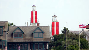
WLeading lights are a pair of light beacons, used in navigation to indicate a safe passage for vessels entering a shallow or dangerous channel; and may also be used for position fixing. At night, the lights are a form of leading line that can be used for safe navigation. The beacons consist of two lights that are separated in distance and elevation, so that when they are aligned, with one above the other, they provide a bearing. Range lights are often illuminated day and night.
 W
WA lightvessel, or lightship, is a ship that acts as a lighthouse. They are used in waters that are too deep or otherwise unsuitable for lighthouse construction. Although some records exist of fire beacons being placed on ships in Roman times, the first modern lightvessel was off the Nore sandbank at the mouth of the River Thames in England, placed there by its inventor Robert Hamblin in 1734. The type has become largely obsolete; lighthouses replaced some stations as the construction techniques for lighthouses advanced, while large, automated buoys replaced others.
 W
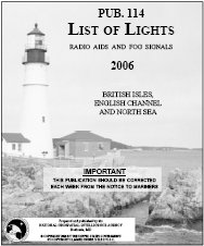
WA list of lights is a publication describing lighthouses and other aids to maritime navigation. Most such lists are published by national hydrographic offices.
 W
WLORAN, short for long range navigation, was a hyperbolic radio navigation system developed in the United States during World War II. It was similar to the UK's Gee system but operated at lower frequencies in order to provide an improved range up to 1,500 miles (2,400 km) with an accuracy of tens of miles. It was first used for ship convoys crossing the Atlantic Ocean, and then by long-range patrol aircraft, but found its main use on the ships and aircraft operating in the Pacific theater during World War II.
 W
WLoran-C was a hyperbolic radio navigation system that allowed a receiver to determine its position by listening to low frequency radio signals transmitted by fixed land-based radio beacons. Loran-C combined two different techniques to provide a signal that was both long-range and highly accurate, features that were formerly incompatible. The disadvantage was the expense of the equipment needed to interpret the signals, which meant that Loran-C was used primarily by militaries after it was introduced in 1957.
 W
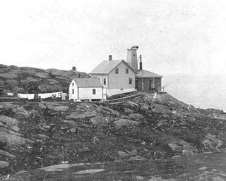
WThe Manana Island Sound Signal Station is an active fog signal station on Manana Island, Maine, United States. Established in 1855, it is one of the only separately managed fog signals in the United States, having been operationally independent of Monhegan Island Light for most of its existence. It is also home to the only known fog signal trumpet tower, built in 1889. The station was listed on the National Register of Historic Places as Manana Island Fog Signal Station in 2002.
 W
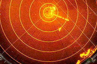
WMarine radars are X band or S band radars on ships, used to detect other ships and land obstacles, to provide bearing and distance for collision avoidance and navigation at sea. They are electronic navigation instruments that use a rotating antenna to sweep a narrow beam of microwaves around the water surface surrounding the ship to the horizon, detecting targets by microwaves reflected from them, generating a picture of the ship's surroundings on a display screen.
 W
WNAVTEX, sometimes styled Navtex or NavTex, is an international automated medium frequency direct-printing service for delivery of navigational and meteorological warnings and forecasts, as well as urgent maritime safety information (MSI) to ships.
 W
WThe U.S. Coast Guard Cutter Oak is a United States Coast Guard seagoing buoy tender; the second of her name and the eleventh of the Juniper class. Home ported in Newport, Rhode Island the "Maine Responder" maintains Aids to Navigation (ATON) along the rugged New England coastline, promoting economic security through navigation safety of the Marine Transportation System. A multi-mission platform, the cutter can also support search & rescue, domestic icebreaking, living marine resources maritime law enforcement, environmental protection, national defense and homeland security missions. The cutter occasionally assists with maintenance support of the National Oceanic and Atmospheric Administration (NOAA) National Data Buoy Center's offshore weather buoys.
 W
WOboe was a British aerial blind bombing system in World War II, based on radio transponder technology. The system consisted of a pair of radio transmitters on the ground, which sent signals which were received and retransmitted by a transponder in the aircraft. By comparing the time each signal took to reach the aircraft, the distance between the aircraft and the station could be determined. The Oboe operators then sent radio signals to the aircraft to bring them onto their target and properly time the release of their bombs.
 W
WOpenCPN is a free software project to create a concise chart plotter and navigation software, for use underway or as a planning tool. OpenCPN is developed by a team of active sailors using real world conditions for program testing and refinement.
 W
WThe PEL sector light is a projector style marine beacon which is used to guide maritime vessels. It does this by projecting a colored sector out to sea with very sharp color changes as the mariner transitions from one sector to the next. Typical PEL sector lights will have a complete color change over 1 meter when the mariner is 5 km from the beacon. The PEL's application becomes relevant to the mariner when combined with a local marine chart as each application of a PEL varies greatly. They are used for guiding vessels into harbor, traffic separation or to illuminate hazards. The main advantage to a PEL sector light is that it has very sharp transitions between colors and is bright enough to be used in daylight with up to 10 Nautical Miles or 18.5 km visibility.
 W
WIn marine navigation, a pelorus is a reference tool for maintaining bearing of a vessel at sea. It is a "dumb compass" without a directive element, suitably mounted and provided with vanes to permit observation of relative bearings.
 W
WRadar beacon is – according to article 1.103 of the International Telecommunication Union's (ITU) ITU Radio Regulations (RR) – defined as "A transmitter-receiver associated with a fixed navigational mark which, when triggered by a radar, automatically returns a distinctive signal which can appear on the display of the triggering radar, providing range, bearing and identification information." Each station shall be classified by the service in which it operates permanently or temporarily.
 W
WRadar navigation is the utilization of marine and aviation radar systems for vessel and aircraft navigation. When a craft is within radar range of land or special radar aids to navigation, the navigator can take distances and angular bearings to charted objects and use these to establish arcs of position and lines of position on a chart. A fix consisting of only radar information is called a radar fix.
 W
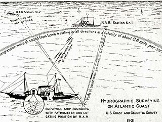
WRadio acoustic ranging, occasionally written as "radio-acoustic ranging" and sometimes abbreviated RAR, was a method for determining a ship's precise location at sea by detonating an explosive charge underwater near the ship, detecting the arrival of the underwater sound waves at remote locations, and radioing the time of arrival of the sound waves at the remote stations to the ship, allowing the ship's crew to use true range multilateration to determine the ship's position. Developed by the United States Coast and Geodetic Survey in 1923 and 1924 for use in accurately fixing the position of survey ships during hydrographic survey operations, it was the first navigation technique in human history other than dead reckoning that did not require visual observation of a landmark, marker, light, or celestial body, and the first non-visual means to provide precise positions. First employed operationally in 1924, radio acoustic ranging remained in use until 1944, when new radio navigation techniques developed during World War II rendered it obsolete.
 W
WRadiofacsimile, radiofax or HF fax is an analogue mode for transmitting monochrome images via high frequency (HF) radio waves. It was the predecessor to slow-scan television (SSTV). It was the primary method of sending photographs from remote sites from the 1930s to the early 1970s. It is still in limited use for transmitting weather charts and information to ships at sea.
 W
WA signal station is a form of Aids to Navigation that is defined by the IHO simply as "A signal station is a place on shore from which signals are made to ships at sea". While this broad definition would include coastal radio stations and fog signal stations, the term is most often used for shore installation that use visual signals to communicate with ships at sea.
 W
WSubmarine signals or Submarine signal had a specific, even proprietary, meaning in the early 20th century. It applied to a navigation aid system developed, patented and produced by the Submarine Signal Company of Boston. The company produced submarine acoustic signals, first bells and receivers then transducers, as aids to navigation. The signals were fixed, associated with lights and other fixed aids, or installed aboard ships enabling warning of fixed hazards or signaling between ships. ATLAS-Werke, at the time Norddeutsche Maschinenund Armaturenfabrik, of Germany also manufactured the equipment under license largely for the European market.
 W
WUSCGC Sycamore (WLB-209) is a United States Coast Guard seagoing buoy tender, the second of her name and the ninth of the Juniper-class. She is now home-ported in Newport, Rhode Island, following a one year long Midlife Maintenance Availability (MMA) in Baltimore, Maryland. She was originally home-ported in Cordova, Alaska. Sycamore primarily tends to aids-to-navigation (ATON) in Martha's Vineyard, the Long Island Sound, Hudson River, and New York City Harbor and entrances; however she is also responsible for maintenance support of National Data Buoy Center's offshore weather buoys. In addition to her primary ATON role, Sycamore also performs other duties, such as, marine environmental protection, maritime law enforcement, domestic icebreaking, search and rescue, and homeland security missions.
 W
WCCGS Tracy was a Marine service vessel and navigational aid tender operated by the Canadian Coast Guard. Designed for service on the Great Lakes and the Saint Lawrence River, the ship joined the fleet in 1968 and was stationed at Canadian Coast Guard Base at Sorel, Quebec and serviced the Quebec Region. The vessel was taken out of service in 2013 and was sold in 2017 to private interests.
 W
WA vessel traffic service (VTS) is a marine traffic monitoring system established by harbour or port authorities, similar to air traffic control for aircraft. The International Maritime Organization defines VTS as "a service implemented by a competent authority designed to improve the safety and efficiency of vessel traffic and protect the environment. The service shall have the capability to interact with the traffic and respond to traffic situations developing in the VTS area". Typical VTS systems use radar, closed-circuit television (CCTV), VHF radiotelephony and automatic identification system to keep track of vessel movements and provide navigational safety in a limited geographical area.
 W
WA vippefyr or bascule light or tipping lantern was a type of small navigational aid popular in Denmark in the 18th century and before. It consisted of a basket in which wood or coal was set; this was then burned. The basket was affixed to a lever that allowed it to be manipulated as required. The vippefyr system was generally viewed as ineffective, as it produced little light and was usually unreliable.
 W
WA VORTAC is a radio-based navigational aid for aircraft pilots consisting of a co-located VHF omnidirectional range (VOR) beacon and a tactical air navigation system (TACAN) beacon. Both types of beacons provide pilots azimuth information, but the VOR system is generally used by civil aircraft and the TACAN system by military aircraft. However, the TACAN distance measuring equipment is also used for civil purposes because civil DME equipment is built to match the military DME specifications. Most VOR installations in the United States are VORTACs. The system was designed and developed by the Cardion Corporation.
 W
WThe Wide Area Augmentation System (WAAS) is an air navigation aid developed by the Federal Aviation Administration to augment the Global Positioning System (GPS), with the goal of improving its accuracy, integrity, and availability. Essentially, WAAS is intended to enable aircraft to rely on GPS for all phases of flight, including precision approaches to any airport within its coverage area. It may be further enhanced with the Local Area Augmentation System (LAAS) also known by the preferred ICAO term Ground-Based Augmentation System (GBAS) in critical areas.
 W
WThe USCGC Willow (WLB-202) is a United States Coast Guard seagoing buoy tender, the third of her name and the second of the Juniper-class. She is home-ported in Charleston, South Carolina, where she replaced her sister ship USCGC Oak in servicing 257 aids to navigation in District 7. Willow's area of operations stretches from South Carolina down to Caribbean, including Puerto Rico, Cuba, U.S. Virgin Islands and Haiti. In addition to her primary aids-to-navigation (ATON) role, Willow also performs other duties, such as maritime border security, marine environmental protection, maritime law enforcement, and search and rescue. The Willow transitioned from her former home port of Newport, RI in 2017 after spending over a year in a Baltimore dry dock being refitted and modernized.
 W
WThe Yeoman Plotter was a plotter used on ships and boats to transfer GPS coordinates or RADAR echo locations onto a paper navigation chart and to read coordinates from the chart. It was manufactured from 1985 to 2014/2015 and was an intermediary step between traditional paper chart navigation and full electronic chart displays. It was easy to understand for people that were accustomed to paper charts and much cheaper than electronic chart displays available at the time. The continuing fall in prices of electronic chart displays, their increase in functionality such as radar overlay and the advent of cheap tablets eventually made the Yeoman plotter uncompetitive.