OpenStreetMap (OSM) is a collaborative project to create a free editable map of the world. The geodata underlying the map is considered the primary output of the project. The creation and growth of OSM has been motivated by restrictions on use or availability of map data across much of the world, and the advent of inexpensive portable satellite navigation devices.
CycleStreets is not-for-profit United Kingdom organisation that provides a free-to-use national cycle journey planner for the United Kingdom. The planner uses OpenStreetMap data for routing, Shuttle Radar Topography Mission for height data and official postcode data. It was launched in March 2009 and by January 2010 had planned 100,000 journeys. As of August 2015, the site has planned over 45 million itineraries. It was 'Highly Commended' at the 2009 ACT Travelwise awards. It provides worldwide routing using OpenStreetMap data.
iD is a free software online editor for OpenStreetMap (OSM) geodata created in JavaScript and released in 2013. It is a default editor on the main OSM page. iD's features include choosing custom aerial imagery and native support for Mapillary photos. Specialized forks of iD include RapiD, developed by Facebook as an import tool for reviewing and adding roads detected by proprietary Facebook algorithms.
 W
WJOSM (Java OpenStreetMap Editor) is a free software desktop editing tool for OpenStreetMap geodata created in Java, originally developed by Immanuel Scholz and currently maintained by Dirk Stöcker. The editing tool contains advanced features that are not present in OSM's default online editor, iD.
 W
WMaps.me is a mobile app for Android, iOS and BlackBerry that provides offline maps using OpenStreetMap data. It was formerly known as MapsWithMe. In November 2014, it was acquired by Mail.Ru Group and became part of its My.com brand. In September 2015, the app was open sourced. First, the whole team has developed an application in Belarus and Switzerland. Maps.me was founded by Yury Melnichek, Alexander Borsuk, Viktor Govako and Siarhei Rachytski. Under the leadership of Alexander, MapsWithMe got its first 2.5M users worldwide. Yury Melnichek was leading the project from November 2013 until April 2016 when Evgeny Lisovskiy took over. In early 2017 the philosophy of the app changed, leading it to be supported by unobtrusive adverts. On Nov 2020 Mail.ru Group sold Maps.me to Daegu Ltd.
 W
WMissing Maps is a humanitarian project that preemptively maps parts of the world that are vulnerable to natural disasters, conflicts, and disease epidemics. It was founded in November 2014 by the American Red Cross, British Red Cross, Humanitarian OpenStreetMap Team, and Médecins Sans Frontières/Doctors Without Borders and has so far mapped large towns and cities in countries such as South Sudan, the Democratic Republic of the Congo, and the Central African Republic.
The Open Database License (ODbL) is a copyleft license agreement intended to allow users to freely share, modify, and use a database while maintaining this same freedom for others.
 W
WThe Open Source Routing Machine or OSRM is a C++ implementation of a high-performance routing engine for shortest paths in road networks. Licensed under the permissive 2-clause BSD license, OSRM is a free network service. OSRM supports Linux, FreeBSD, Windows, and Mac OS X platform.
OpenSeaMap is a software project collecting freely usable nautical information and geospatial data to create a worldwide nautical chart. This chart is available on the OpenSeaMap website, and can also be downloaded for use as an electronic chart for offline applications.
OsmAnd is a map and navigation app for Android and iOS. It uses the OpenStreetMap (OSM) map database for its primary displays, but is an independent app not endorsed by the OpenStreetMap Foundation. It is available in both free and paid versions; the latter unlocks the download limit for offline maps and provides access to Wikipedia points of interest (POIs) and their descriptions from within the app. Map data can be stored on the device for offline use. Using the device's GPS capabilities, OsmAnd offers routing, with visual and voice guidance, for car, bike, and pedestrian. All of the main functionalities work both online and offline.
Potlatch is a free software editing tool for OpenStreetMap geodata using Adobe AIR. For many years embedded directly within the OpenStreetMap website using Adobe Flash, it was rebuilt as a desktop application following the end-of-lifing of Flash. It continues to be actively maintained.
 W
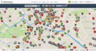
WWheelmap.org is an online, worldwide map for finding and marking wheelchair accessible places, developed by the German nonprofit organisation Sozialhelden e.V. Anyone can find and add public places to the map and rate them according to a simple traffic light system. The map, which is based on OpenStreetMap, was created in 2010 by a team around social entrepreneur Raul Krauthausen to help people who use wheelchairs or wheeled walkers to plan their days more easily. Parents pushing a baby carriage can also benefit from the Wheelmap information. Currently almost 600,000 public places worldwide can be found on the map. About 300 new places are added on a daily basis. Wheelmap is available on the website and as an app for iOS, Android and Windows Phone.