 W
WThe geographic centre of Uganda is north of Lake Kyoga in Olyaka village, Olyaka parish in Namasale sub-county in Amolatar District, Northern Uganda.
 W
WThe location of the geographical centre of Asia depends on the definition of the borders of Asia, mainly whether remote islands are included to define the extreme points of Asia, and on the method of calculating the final result.
 W
WCentre points of Australia are those geographical locations that have been considered to be centre of Australia, as distinct from the extreme points of Australia.
 W
WIn astronomy, axis mundi is the Latin term for the axis of Earth between the celestial poles.
 W
WBrennand Farm is often claimed to be the true centre of Great Britain. This is about seven kilometres north-west of Dunsop Bridge - which has the nearest BT phone box to the 'true centre'. A plaque reads “You are calling from the BT payphone that marks the centre of Great Britain”.
 W
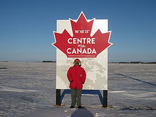
WThere are several ways of determining the centre of Canada giving different locations.There is a sign on the Trans-Canada Highway at 96°48'35"W proclaiming it the longitudinal centre of Canada; in effect, the north-south line midway between the extreme points of Canada on the east and west, including islands. This is 20 minutes west of the location given by the Atlas of Canada, however. See also: 96th meridian west and 97th meridian west.
 W
WThe geographical centre of Earth is the geometric centre of all land surfaces on Earth. In a more strict definition, it is the superficial barycenter of the mass distribution produced by treating each continent or island as a region of a thin shell of uniform density and approximating the geoid with a sphere. The centre is inside Earth but can be projected to the closest point on the surface.
 W
WThe location of the geographical centre of Europe depends on the definition of the borders of Europe, mainly whether remote islands are included to define the extreme points of Europe, and on the method of calculating the final result. Thus, several places claim to host this hypothetical centre.
 W
WCentral Germany (Zentraldeutschland/Mitteldeutschland), in geography, describes the areas surrounding the geographical centre of Germany.
 W
WThe geographical centre of Ireland, according to the Irish Ordnance Survey, is in the townland of Carnagh East, County Roscommon on the western shore of Lough Ree, where the 8° Meridian West meets the 53°30' North Latitude. It is opposite the Cribby Islands and 8.85 kilometres NNW of Athlone Town. Lecarrow is the closest population centre.
 W
WNiederdorla is a village and a former municipality in the Unstrut-Hainich-Kreis district of Thuringia, Germany. It is the geographical center of Germany. Its nearest main city is Erfurt, which also is the capital city of Thuringia. Since 31 December 2012, it is part of the municipality Vogtei.
 W
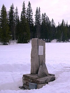
WThe geographical centre of Norway has been identified as a spot in the Ogndalsfjella in the southeastern part of the municipality of Steinkjer in Trøndelag county, located at 63°59′26″N 12°18′28″E. A monument marking the significance of the spot was unveiled in a ceremony on 3 September 2006. It is hoped that it will become a tourist attraction. The site lies just to the west of the large lake Skjækervatnet.
 W
W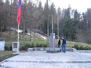 W
WThe Geometric Centre of Slovenia is the geometric centre of the country. Its geographic coordinates are 46°07′11.8″N 14°48′55.2″E and its elevation is 644.842 m. It lies in the hamlet of Spodnja Slivna near Vače in the Municipality of Litija. Since 4 July 1982, it has been marked with a memorial stone designed by the architect Marjan Božič, about 50 m away from the given coordinates. A plaque reading Živimo in gospodarimo na svoji zemlji was added on 14 September 1989. In 2003, Slovenia adopted an act on GEOSS.
 W
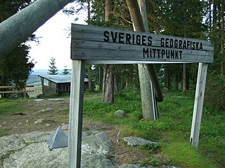
WThe geographical center of Sweden is contested amongst at least two locations.
 W
WThe geographical centre of Switzerland has the coordinates 46°48′4″N 8°13′36″E. It is located at Älggi-Alp in the municipality of Sachseln, Obwalden. The point is the centre of mass determined in 1988 by Swisstopo.
 W
WGeographic Center of Taiwan is the center point of Taiwan Island. It is located at Mount Hutou (t 虎頭山, s 虎头山, Hutoushan, "Tiger Head Mountain") in the township of Puli in Nantou County, Taiwan.
 W
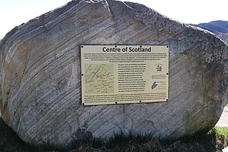
WThere has long been debate over the exact location of the geographical centre of the United Kingdom, and its constituent countries, due to the complexity and method of the calculation, such as whether to include offshore islands, and the fact that erosion will cause the position to change over time. There are two main methods of calculating this "centre": either as the centroid of the two-dimensional shape made by the country, or as the point farthest from the boundary of the country. These two methods give quite different answers.
 W
WThe geographic center of the contiguous United States is the center of 48 U.S. states. It has been regarded as such by the U.S. National Geodetic Survey (NGS) since the 1912 additions of New Mexico and Arizona to the United States.
 W
WThe geographic center of the United States is a point approximately 20 mi (32 km) north of Belle Fourche, South Dakota at 44°58′2.07622″N 103°46′17.60283″W. It has been regarded as such by the U.S. National Geodetic Survey (NGS) since the additions of Alaska and Hawaii to the United States in 1959.
 W
WZero Mile Stone is a monument built by British during the Great Trigonometrical Survey of India in 1907 in Nagpur, Maharashtra. The Zero Mile Stone consists of a pillar made up of sandstone and another small stone representing the GTS Standard Bench Mark, and four stucco horses that were added later. The height of the top of the pillar is 1020.171 feet above mean sea level. In 2008, The Times of India undertook to maintain the monument for the next 5 years.