 W
WIn meteorology, a cyclone (/ˈsaɪ.kloʊn/) is a large scale air mass that rotates around a strong center of low atmospheric pressure. Cyclones are characterized by inward spiraling winds that rotate about a zone of low pressure. The largest low-pressure systems are polar vortices and extratropical cyclones of the largest scale. Warm-core cyclones such as tropical cyclones and subtropical cyclones also lie within the synoptic scale. Mesocyclones, tornadoes, and dust devils lie within smaller mesoscale. Upper level cyclones can exist without the presence of a surface low, and can pinch off from the base of the tropical upper tropospheric trough during the summer months in the Northern Hemisphere. Cyclones have also been seen on extraterrestrial planets, such as Mars, Jupiter, and Neptune. Cyclogenesis is the process of cyclone formation and intensification. Extratropical cyclones begin as waves in large regions of enhanced mid-latitude temperature contrasts called baroclinic zones. These zones contract and form weather fronts as the cyclonic circulation closes and intensifies. Later in their life cycle, extratropical cyclones occlude as cold air masses undercut the warmer air and become cold core systems. A cyclone's track is guided over the course of its 2 to 6 day life cycle by the steering flow of the subtropical jet stream.
 W
WThe Aleutian Low is a semi-permanent low-pressure system located near the Aleutian Islands in the Bering Sea during the Northern Hemisphere winter. It is a climatic feature centered near the Aleutian Islands measured based on mean sea-level pressure. It is one of the largest atmospheric circulation patterns in Northern Hemisphere and represents one of the "main centers of action in atmospheric circulation."
 W
WAustralian east coast lows are extratropical cyclones. The most intense of these systems have many of the characteristics of subtropical cyclones. They develop between 25˚ south and 40˚ south and within 5˚ of the Australian coastline, typically during the winter months, but may occur in autumn and spring as well. Each year there are about ten "significant impact" maritime lows.
 W
WExplosive cyclogenesis is the rapid deepening of an extratropical cyclonic low-pressure area. The change in pressure needed to classify something as explosive cyclogenesis is latitude dependent. For example, at 60° latitude, explosive cyclogenesis occurs if the central pressure decreases by 24 mbar (hPa) or more in 24 hours. This is a predominantly maritime, winter event, but also occurs in continental settings, even in the summer. This process is the extratropical equivalent of the tropical rapid deepening. Although their cyclogenesis is totally different from that of tropical cyclones, bomb cyclones can produce winds of 74 to 95 mph the same order as the first categories of the Saffir-Simpson scale and give heavy precipitation. Even though only a minority of the bombs become so strong, some weaker ones have also caused significant damage.
 W
WA cold-core low, also known as an upper level low or cold-core cyclone, is a cyclone aloft which has an associated cold pool of air residing at high altitude within the Earth's troposphere, without a frontal structure. It is a low pressure system that strengthens with height in accordance with the thermal wind relationship. If a weak surface circulation forms in response to such a feature at subtropical latitudes of the eastern north Pacific or north Indian oceans, it is called a subtropical cyclone. Cloud cover and rainfall mainly occurs with these systems during the day. Severe weather, such as tornadoes, can occur near the center of cold-core lows. Cold lows can help spawn cyclones with significant weather impacts, such as polar lows, and Kármán vortices. Cold lows can lead directly to the development of tropical cyclones, owing to their associated cold pool of air aloft or by acting as additional outflow channels to aid in further development.
 W
WThe December 2019 North American Storm Complex was an extratropical cyclone that dumped heavy rain in the Southeast United States. Forming from a front in the Gulf Of Mexico on December 20th, 2019, it organized into an extratropical cyclone, and with most of the convection pushed to the northeast of the center, it gave heavy rains that prompted flash flooding in the Southeast. The center later moved over Florida on December 24th, and dissipated on December 26th.
 W
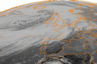
WEuropean windstorms are powerful extratropical cyclones which form as cyclonic windstorms associated with areas of low atmospheric pressure. They can occur throughout the year, but are most frequent between October and March, with peak intensity in the winter months. Deep areas of low pressure are common over the North Atlantic, and occasionally start as nor'easters off the New England coast. They frequently track across the North Atlantic Ocean towards the north of Scotland and into the Norwegian Sea, which generally minimizes the impact to inland areas; however, if the track is further south, it may cause adverse weather conditions across Central Europe, Northern Europe and especially Western Europe. The countries most commonly affected include the United Kingdom, Ireland, the Netherlands, Norway, the Faroe Islands and Iceland.
 W
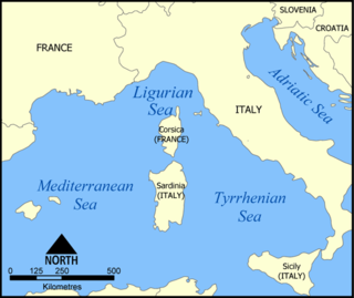
WA Genoa low is a cyclone that forms or intensifies from a pre-existing cyclone to the south of the Alps over the Gulf of Genoa, Ligurian Sea, Po Valley and northern Adriatic. Vb cyclones are rare events which occur on average only 2.3 times per year.
 W
WThe Icelandic Low is a semi-permanent centre of low atmospheric pressure found between Iceland and southern Greenland and extending in the Northern Hemisphere winter into the Barents Sea. In summer it weakens and splits into two centres, one near Davis Strait and the other west of Iceland. It is a principal centre of action in the atmosphere circulation of the Northern Hemisphere, associated with frequent cyclone activity. It forms one pole of the North Atlantic oscillation, the other being the Azores High.
 W
WKona storms are a type of seasonal cyclone in the Hawaiian Islands, usually formed in the winter from winds coming from the westerly "kona" direction. They are mainly cold core cyclones, which places them in the extratropical cyclone rather than the subtropical cyclone category. Hawaii typically experiences two to three annually, which can affect the state for a week or more. Among their hazards are heavy rain, hailstorms, flash floods and their associated landslides, high elevation snow, high winds which result in large surf and swells, and waterspouts.
 W
WA low-pressure area, low area or low is a region where the air pressure is lower than that of surrounding locations. Low-pressure systems form under areas of wind divergence that occur in the upper levels of the atmosphere. The formation process of a low-pressure area is known as cyclogenesis. Within the field of meteorology, atmospheric divergence aloft occurs in two areas. The first area is on the east side of upper troughs, which form half of a Rossby wave within the Westerlies. A second area of wind divergence aloft occurs ahead of embedded shortwave troughs, which are of smaller wavelength. Diverging winds aloft ahead of these troughs cause atmospheric lift within the troposphere below, which lowers surface pressures as upward motion partially counteracts the force of gravity.
 W
WMediterranean tropical-like cyclones, often referred to as medicanes but sometimes also as Mediterranean cyclones or as Mediterranean hurricanes, are meteorological phenomena observed over the Mediterranean Sea. On a few rare occasions, some storms have been observed reaching the strength of a Category 1 hurricane. The main societal hazard posed by medicanes is not usually from destructive winds, but through life-threatening torrential rains and flash floods.
 W
WA mesocyclone is storm-scale region of rotation (vortex), typically around 2 to 6 mi in diameter, within a thunderstorm. In the northern hemisphere it is particularly found in the right rear flank of a supercell or often on the eastern, or front, flank of an HP storm. The circulation of a mesocyclone covers an area much larger than the tornado that may develop within it.
 W
WA polar low is a small-scale, short-lived atmospheric low pressure system (depression) that is found over the ocean areas poleward of the main polar front in both the Northern and Southern Hemispheres, as well as the Sea of Japan. The systems usually have a horizontal length scale of less than 1,000 kilometres (620 mi) and exist for no more than a couple of days. They are part of the larger class of mesoscale weather systems. Polar lows can be difficult to detect using conventional weather reports and are a hazard to high-latitude operations, such as shipping and gas and oil platforms. Polar lows have been referred to by many other terms, such as polar mesoscale vortex, Arctic hurricane, Arctic low, and cold air depression. Today the term is usually reserved for the more vigorous systems that have near-surface winds of at least 17 m/s (38 mph).
 W
WA post-tropical cyclone is a former tropical cyclone. The word may refer to a former tropical cyclone undergoing extratropical transition, a tropical cyclone degenerating into a remnant low, or a tropical cyclone degenerating into a trough.
 W
WA steam devil is a small, weak whirlwind over water that has drawn fog into the vortex, thus rendering it visible.
 W
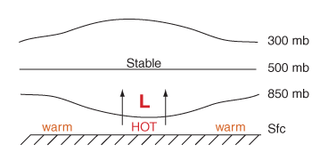
WThermal lows, or heat lows, are non-frontal low-pressure areas that occur over the continents in the subtropics during the warm season, as the result of intense heating when compared to their surrounding environments. Thermal lows occur near the Sonoran Desert, on the Mexican plateau, in California's Great Central Valley, the Sahara, over north-west Argentina in South America, over the Kimberley region of north-west Australia, the Iberian peninsula, and the Tibetan plateau.
 W
WA tornado is a violently rotating column of air that is in contact with both the surface of the Earth and a cumulonimbus cloud or, in rare cases, the base of a cumulus cloud. The windstorm is often referred to as a twister, whirlwind or cyclone, although the word cyclone is used in meteorology to name a weather system with a low-pressure area in the center around which, from an observer looking down toward the surface of the earth, winds blow counterclockwise in the Northern Hemisphere and clockwise in the Southern. Tornadoes come in many shapes and sizes, and they are often visible in the form of a condensation funnel originating from the base of a cumulonimbus cloud, with a cloud of rotating debris and dust beneath it. Most tornadoes have wind speeds less than 110 miles per hour (180 km/h), are about 250 feet (80 m) across, and travel a few miles before dissipating. The most extreme tornadoes can attain wind speeds of more than 300 miles per hour (480 km/h), are more than two miles (3 km) in diameter, and stay on the ground for dozens of miles.
 W
WA tropical cyclone is a rapidly rotating storm system characterized by a low-pressure center, a closed low-level atmospheric circulation, strong winds, and a spiral arrangement of thunderstorms that produce heavy rain or squalls. Depending on its location and strength, a tropical cyclone is referred to by different names, including hurricane, typhoon, tropical storm, cyclonic storm, tropical depression, and simply cyclone. A hurricane is a tropical cyclone that occurs in the Atlantic Ocean and northeastern Pacific Ocean, and a typhoon occurs in the northwestern Pacific Ocean; in the south Pacific or Indian Ocean, comparable storms are referred to simply as "tropical cyclones" or "severe cyclonic storms".
WAn upper tropospheric cyclonic vortex is a vortex, or a circulation with a definable center, that usually moves slowly from east-northeast to west-southwest and is prevalent across Northern Hemisphere's warm season. Its circulations generally do not extend below 6,080 metres (19,950 ft) in altitude, as it is an example of a cold-core low. A weak inverted wave in the easterlies is generally found beneath it, and it may also be associated with broad areas of high-level clouds. Downward development results in an increase of cumulus clouds and the appearance of circulation at ground level. In rare cases, a warm-core cyclone can develop in its associated convective activity, resulting in a tropical cyclone and a weakening and southwest movement of the nearby upper tropospheric cyclonic vortex. Symbiotic relationships can exist between tropical cyclones and the upper level lows in their wake, with the two systems occasionally leading to their mutual strengthening. When they move over land during the warm season, an increase in monsoon rains occurs.
 W
WA wake low, or wake depression, is a mesoscale low-pressure area which trails the mesoscale high following a squall line. Due to the subsiding warm air associated with the system's formation, clearing skies are associated with the wake low. Once difficult to detect in surface weather observations due to their broad spacing, the formation of mesoscale weather station networks, or mesonets, has increased their detection. Severe weather, in the form of high winds, can be generated by the wake low when the pressure difference between the mesohigh preceding it and the wake low is intense enough. When the squall line is in the process of decay, heat bursts can be generated near the wake low. Once new thunderstorm activity along the squall line concludes, the wake low associated with it weakens in tandem.