 W
WRemote sensing is the acquisition of information about an object or phenomenon without making physical contact with the object and thus is in contrast to on-site observation. The term is applied especially to acquiring information about the Earth. Remote sensing is used in numerous fields, including geography, land surveying and most Earth science disciplines ; it also has military, intelligence, commercial, economic, planning, and humanitarian applications, among others.
 W
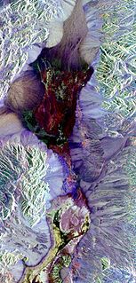
WRemote sensing in geology is remote sensing used in the geological sciences as a data acquisition method complementary to field observation, because it allows mapping of geological characteristics of regions without physical contact with the areas being explored. About one-fourth of the Earth's total surface area is exposed land where information is ready to be extracted from detailed earth observation via remote sensing. Remote sensing is conducted via detection of electromagnetic radiation by sensors. The radiation can be naturally sourced, or produced by machines and reflected off of the Earth surface. The electromagnetic radiation acts as an information carrier for two main variables. First, the intensities of reflectance at different wavelengths are detected, and plotted on a spectral reflectance curve. This spectral fingerprint is governed by the physio-chemical properties of the surface of the target object and therefore helps mineral identification and hence geological mapping, for example by hyperspectral imaging. Second, the two-way travel time of radiation from and back to the sensor can calculate the distance in active remote sensing systems, for example, Interferometric synthetic-aperture radar. This helps geomorphological studies of ground motion, and thus can illuminate deformations associated with landslides, earthquakes, etc.
 W
WPhotographic interpretation is “the act of examining photographic images for the purpose of identifying objects and judging their significance”. This mainly refers to its usage in military aerial reconnaissance using photographs taken from reconnaissance aircraft and satellites.
 W
WAerial video is an emerging form of data acquisition for scene understanding and object tracking. The video is captured by low flying aerial platforms that integrate Global Positioning Systems (GPS) and automated image processing to improve the accuracy and cost-effectiveness of data collection and reduction. Recorders can incorporate in-flight voice records from the cockpit intercom system. The addition of audio narration is an extremely valuable tool for documentation and communication. GPS data is incorporated with a text-captioning device on each video frame. Helicopter platforms enable "low and slow" flights, acquiring a continuous visual record without motion blur.
 W
WThe bidirectional reflectance distribution function is a function of four real variables that defines how light is reflected at an opaque surface. It is employed in the optics of real-world light, in computer graphics algorithms, and in computer vision algorithms. The function takes an incoming light direction, , and outgoing direction, , and returns the ratio of reflected radiance exiting along to the irradiance incident on the surface from direction . Each direction is itself parameterized by azimuth angle and zenith angle , therefore the BRDF as a whole is a function of 4 variables. The BRDF has units sr−1, with steradians (sr) being a unit of solid angle.
 W
WIn atmospheric chemistry, differential optical absorption spectroscopy (DOAS) is used to measure concentrations of trace gases. When combined with basic optical spectrometers such as prisms or diffraction gratings and automated, ground-based observation platforms, it presents a cheap and powerful means for the measurement of trace gas species such as ozone and nitrogen dioxide. Typical setups allow for detection limits corresponding to optical depths of 0.0001 along lightpaths of up to typically 15 km and thus allow for the detection also of weak absorbers, such as water vapour, Nitrous acid, Formaldehyde, Tetraoxygen, Iodine oxide, Bromine oxide and Chlorine oxide.
 W
WA digital elevation model (DEM) is a 3D computer graphics representation of elevation data to represent terrain, commonly of a planet, moon, or asteroid. A "global DEM" refers to a discrete global grid. DEMs are used often in geographic information systems, and are the most common basis for digitally produced relief maps.
 W
WGNSS reflectometry involves making measurements from the reflections from the Earth of navigation signals from Global Navigation Satellite Systems such as GPS. The idea of using reflected GNSS signal for earth observation became more and more popular in the mid-1990s at NASA Langley research centre and is also known as GPS reflectometry. Research applications of GNSS-R are found inAltimetry Oceanography Cryosphere monitoring Soil moisture monitoring
 W
WHemispherical photography, also known as canopy photography, is a technique to estimate solar radiation and characterize plant canopy geometry using photographs taken looking upward through an extreme wide-angle lens or a fisheye lens. Typically, the viewing angle approaches or equals 180-degrees, such that all sky directions are simultaneously visible. The resulting photographs record the geometry of visible sky, or conversely the geometry of sky obstruction by plant canopies or other near-ground features. This geometry can be measured precisely and used to calculate solar radiation transmitted through plant canopies, as well as to estimate aspects of canopy structure such as leaf area index. Detailed treatments of field and analytical methodology have been provided by Paul Rich and Robert Pearcy (1989).
 W
WHydroacoustics is the study and application of sound in water. Hydroacoustics, using sonar technology, is most commonly used for monitoring of underwater physical and biological characteristics.
 W
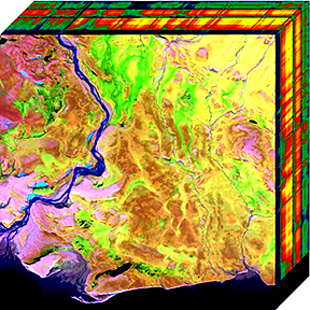
WHyperspectral imaging, like other spectral imaging, collects and processes information from across the electromagnetic spectrum. The goal of hyperspectral imaging is to obtain the spectrum for each pixel in the image of a scene, with the purpose of finding objects, identifying materials, or detecting processes. There are three general branches of spectral imagers. There are push broom scanners and the related whisk broom scanners, which read images over time, band sequential scanners, which acquire images of an area at different wavelengths, and snapshot hyperspectral imaging, which uses a staring array to generate an image in an instant.
 W
WThe Land Remote-Sensing Commercialization Act of 1984 is a United States statute establishing a system to further the utilization of satellite imagery data obtained from Earth observation satellites located in a geocentric orbit above the atmosphere of Earth.
 W
WMETRIC is a computer model developed by the University of Idaho, that uses Landsat satellite data to compute and map evapotranspiration (ET). METRIC calculates ET as a residual of the surface energy balance, where ET is estimated by keeping account of total net short wave and long wave radiation at the vegetation or soil surface, the amount of heat conducted into soil, and the amount of heat convected into the air above the surface. The difference in these three terms represents the amount of energy absorbed during the conversion of liquid water to vapor, which is ET. METRIC expresses near-surface temperature gradients used in heat convection as indexed functions of radiometric surface temperature, thereby eliminating the need for absolutely accurate surface temperature and the need for air-temperature measurements.
 W
WThe moment distance index (MDI) is a shape-based metric or shape index that can be used to analyze spectral reflectance curves and waveform LiDAR, proposed by Salas and Henebry in 2014. In the case of spectral data, the shape of the reflectance curve should unmask fine points of the spectra usually not considered by existing band-specific indices. It has been used to identify spectral regions for chlorophyll and carotenoids, detect greenhouses using WorldView-2 and Landsat satellite data, identify greenhouse crops, compute canopy heights, and estimate green vegetation fraction.
 W
WA multispectral image is one that captures image data within specific wavelength ranges across the electromagnetic spectrum. The wavelengths may be separated by filters or detected via the use of instruments that are sensitive to particular wavelengths, including light from frequencies beyond the visible light range, i.e. infrared and ultra-violet. Spectral imaging can allow extraction of additional information the human eye fails to capture with its visible receptors for red, green and blue. It was originally developed for military target identification and reconnaissance. Early space-based imaging platforms incorporated multispectral imaging technology to map details of the Earth related to coastal boundaries, vegetation, and landforms. Multispectral imaging has also found use in document and painting analysis.4
 W
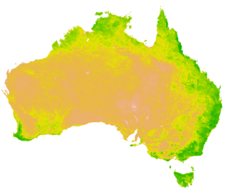
WThe normalized difference vegetation index (NDVI) is a simple graphical indicator that can be used to analyze remote sensing measurements, often from a space platform, assessing whether or not the target being observed contains live green vegetation.
 W
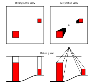
WAn orthophoto, orthophotograph or orthoimage is an aerial photograph or satellite imagery geometrically corrected ("orthorectified") such that the scale is uniform: the photo or image follows a given map projection. Unlike an uncorrected aerial photograph, an orthophoto can be used to measure true distances, because it is an accurate representation of the Earth's surface, having been adjusted for topographic relief, lens distortion, and camera tilt.
 W
WRed edge refers to the region of rapid change in reflectance of vegetation in the near infrared range of the electromagnetic spectrum. Chlorophyll contained in vegetation absorbs most of the light in the visible part of the spectrum but becomes almost transparent at wavelengths greater than 700 nm. The cellular structure of the vegetation then causes this infrared light to be reflected because each cell acts something like an elementary corner reflector. The change can be from 5% to 50% reflectance going from 680 nm to 730 nm. This is an advantage to plants in avoiding overheating during photosynthesis. For a more detailed explanation and a graph of the photosynthetically active radiation (PAR) spectral region, see Normalized difference vegetation index § Rationale.
 W
WMobile mapping is the process of collecting geospatial data from a mobile vehicle, typically fitted with a range of GNSS, photographic, radar, laser, LiDAR or any number of remote sensing systems. Such systems are composed of an integrated array of time synchronised navigation sensors and imaging sensors mounted on a mobile platform. The primary output from such systems include GIS data, digital maps, and georeferenced images and video.
 W
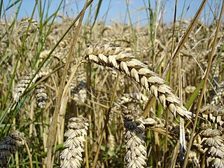
WSatellite crop monitoring is the technology which facilitates real-time crop vegetation index monitoring via spectral analysis of high resolution satellite images for different fields and crops which enables to track positive and negative dynamics of crop development. The difference in vegetation index informs about single-crop development disproportions that speaks for the necessity of additional agriculture works on particular field zones—that is because satellite crop monitoring belongs to precision agriculture methods.
 W
WSpatio-spectral scanning is one of four techniques for hyperspectral imaging, the other three being spatial scanning, spectral scanning and non-scanning, or snapshot hyperspectral imaging.
Specim, Spectral Imaging Ltd is a European technology firm headquartered in Oulu, Finland. Specim manufactures and sells imaging spectrographs, hyperspectral cameras and systems. Specim's airborne AISA hyperspectral cameras have been utilized for example in monitoring the environmental effects of major industrial catastrophes such as Deepwater Horizon oil spill and Red mud spill.
 W
WA swathe or swath is the width of a scythe stroke or a mowing-machine blade, the path of this width made in mowing or the mown grass or grain lying on such a path. The mower with a scythe moves along the mowing-edge with the uncut grass to the right and the cut grass laid in a neat row to the left, on the previously mown land. The swathe width depends on the blade length, the nature of the crop and the mower but is usually about 1.5 metres wide. Mowing may be done by a team of mowers, usually starting at the edges of a meadow then proceeding clockwise leaving a series of staggered swathes and finishing in the middle.
 W
WTasseled cap transformation is a method to transform the spectral information of satellite data into spectral indicators. This index is especially used in the analysis of vegetation.
 W
WTier-scalable reconnaissance is the term for an approach to deploying and controlling vehicles in multiple areas of interest, such as in the exploration of planets or diverse regions on Earth. It is not a rigid or fixed paradigm, but is infinitely extensible. It uses hierarchical levels of oversight called tiers, each tier commanding or controlling the vehicles within the tier beneath it. The size of each tier can be scaled from one to many vehicles.
 W
WA Vegetation Index (VI) is a spectral transformation of two or more bands designed to enhance the contribution of vegetation properties and allow reliable spatial and temporal inter-comparisons of terrestrial photosynthetic activity and canopy structural variations.
 W
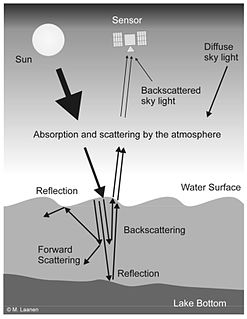
WWater Remote Sensing studies the color of water through the observation of the spectrum of water leaving radiation. From the study of this spectrum, the concentration of optically active components of the upper layer of the water body can be concluded via specific algorithms. Water quality monitoring by remote sensing and close-range instruments has obtained considerable attention since the founding of EU Water Framework Directive.