 W
WTropical Depression One was the wettest tropical cyclone in Cuba since Hurricane Flora of 1963. The first tropical cyclone of the 1988 Atlantic hurricane season, the system developed on May 30 from an area of disturbed weather in the northwestern Caribbean Sea. The tropical depression headed northeastward, making landfall in La Habana Province, Cuba, without intensifying. Crossing Cuba, the depression became very disorganized as it emerged into the Straits of Florida and degenerated into an open trough on June 2. Although only a tropical depression, the system flooded central and western Cuba with over 40 inches (1000 mm) of rain, causing 37 fatalities, damage to over 1,000 houses, and the evacuation of about 65,000 residents.
 W
WThe 1987–88 Australian region cyclone season was the least active tropical cyclone season since 1977–78. It officially started on 1 November 1987, and officially ended on 30 April 1988. The regional tropical cyclone operational plan defines a "tropical cyclone year" separately from a "tropical cyclone season"; the "tropical cyclone year" began on 1 July 1987 and ended on 30 June 1988.
 W
WThe 1987–88 South Pacific cyclone season was a quiet tropical cyclone season with five tropical cyclones and 2 severe tropical cyclones, observed within the South Pacific basin to the east of 160°E.
 W
WThe 1987–88 South-West Indian Ocean cyclone season was a moderately active cyclone season, with nine named storms. Four of the storms attained tropical cyclone status, which is the equivalent of a minimal hurricane with 10 minute sustained winds of at least 120 km/h (75 mph). The seasonal activity was evenly dispersed, officially beginning on December 9 when the Météo-France office (MFR) on Réunion started tracking Tropical Storm Ariny. The storm crossed 90° E from the adjacent Australian basin, one of two storms in the season to do so along with Cyclone Ezenina. There were also two storms tracked unofficially by the Joint Typhoon Warning Center (JTWC) in November.
 W
WThe 1988 Atlantic hurricane season was a near average season that proved costly and deadly, with 15 tropical cyclones directly affecting land. The season officially began on June 1, 1988, and lasted until November 30, 1988, although activity began on May 30 when a tropical depression developed in the Caribbean Sea. The June through November dates conventionally delimit the period of each year when most tropical cyclones form in the Atlantic basin. The first cyclone to attain tropical storm status was Alberto on August 8, nearly a month later than usual. The final storm of the year, Tropical Storm Keith, became extratropical on November 24.
 W
WThe 1988 Bangladesh cyclone was one of the worst tropical cyclones in Bangladeshi history. Striking in November 1988, the tropical system exacerbated the catastrophic damage from what was then considered the worst floods in Bangladesh's history. The tropical cyclone originated from a disturbance that developed within the Strait of Malacca on November 21. Tracking slowly westward, the initial tropical depression reached tropical storm status in the Andaman Sea. On November 26, the storm reached an intensity equivalent to that of a modern-day severe cyclonic storm and subsequently turned northward. Gradually intensifying as it had previously, the tropical cyclone reached peak intensity with winds of 125 mph (200 km/h) as it was making landfall near the Bangladesh–India border on November 29. Although the storm retained strong winds well inland, it was last monitored over central Bangladesh as a moderate cyclonic storm-equivalent on November 30.
 W
WThe 1988 Pacific hurricane season was a Pacific hurricane season that saw a below-average amount of tropical cyclones form, the first time since 1981. It officially began May 15, in the eastern Pacific, and June 1, in the central Pacific and lasted until November 30. These dates conventionally delimit the period of each year when most tropical cyclones form in the northeastern Pacific Ocean. The first named storm, Tropical Storm Aletta, formed on June 16, and the last-named storm, Tropical Storm Miriam, was previously named Hurricane Joan in the Atlantic Ocean before crossing Central America and re-emerging in the eastern Pacific; Miriam continued westward and dissipated on November 2.
 W
WThe 1988 North Indian Ocean cyclone season was part of the annual cycle of tropical cyclone formation. The season has no official bounds but cyclones tend to form between April and December. These dates conventionally delimit the period of each year when most tropical cyclones form in the northern Indian Ocean. There are two main seas in the North Indian Ocean—the Bay of Bengal to the east of the Indian subcontinent and the Arabian Sea to the west of India. The official Regional Specialized Meteorological Centre in this basin is the India Meteorological Department (IMD), while the Joint Typhoon Warning Center (JTWC) releases unofficial advisories. An average of five tropical cyclones form in the North Indian Ocean every season with peaks in May and November. Cyclones occurring between the meridians 45°E and 100°E are included in the season by the IMD.
 W
WThe 1988 Pacific typhoon season has no official bounds; it ran year-round in 1988, but most tropical cyclones tend to form in the northwestern Pacific Ocean between May and November. These dates conventionally delimit the period of each year when most tropical cyclones form in the northwestern Pacific Ocean. Tropical Storms formed in the entire west Pacific basin were assigned a name by the Joint Typhoon Warning Center. Tropical depressions that enter or form in the Philippine area of responsibility are assigned a name by the Philippine Atmospheric, Geophysical and Astronomical Services Administration or PAGASA. This can often result in the same storm having two names.
 W
WThe 1988–89 Australian region cyclone season was a slightly above average tropical cyclone season. It officially started on 1 November 1988, and officially ended on 30 April 1989. The regional tropical cyclone operational plan defines a "tropical cyclone year" separately from a "tropical cyclone season"; the "tropical cyclone year" began on 1 July 1988 and ended on 30 June 1989.
 W
WSevere Tropical Cyclone Anne was one of the most intense tropical cyclones within the South Pacific basin during the 1980s. The cyclone was first noted on January 5, 1988 as a weak tropical depression to the northeast of Tuvalu, in conjunction with the future Typhoon Roy in the Northern Hemisphere. Over the next few days, the system gradually developed while moving southwestward. Once it became a tropical cyclone, it was named Anne on January 8. The next day, Anne rapidly intensified, becoming the fourth major tropical cyclone to affect Vanuatu within four years. On January 11, Anne peaked in intensity while it was equivalent to a Category 5 on the Saffir–Simpson hurricane wind scale, and a Category 4 on the Australian tropical cyclone intensity scale. After turning southward on January 12, Anne struck New Caledonia, becoming the strongest tropical cyclone to affect the French Overseas Territory. The system subsequently weakened as it started to interact with Tropical Cyclone Agi. Anne weakened into a depression and was last noted on January 14 to the south-east of New Caledonia.
 W
WTropical Storm Beryl was an unusual Atlantic tropical cyclone that formed over southeastern Louisiana in August 1988. The second tropical storm of the 1988 Atlantic hurricane season, Beryl developed from a slow-moving trough of low pressure on August 8. It tracked southeastward into the coastal waters of eastern Louisiana, and Beryl reached peak winds of 50 mph (85 km/h) while located about 75 miles (120 km) southeast of New Orleans. The storm turned to the northwest over Louisiana and Texas, and slowly dissipated. The remnants of Beryl continued northward into the central United States, dropping some rainfall and providing relief to a severe heat wave.
 W
WCyclone Bola was one of the costliest cyclones in the history of New Zealand, causing severe damage as an extratropical cyclone when it passed near the country in March 1988. It formed on February 24 to the north of Fiji, and tracking generally southwestward it reached hurricane-force winds near Vanuatu on February 28. The next day it generated peak wind velocities of 195 km/h (120 mph), though it quickly weakened as it accelerated southward. On March 4, Bola transitioned into an extratropical storm, passing to the north of the North Island of New Zealand on March 8. It weakened further and was absorbed by a stationary trough near the South Island on March 12.
 W
WTropical Storm Chris caused minor flooding in the Greater Antilles and the Eastern United States in August 1988. The seventh tropical cyclone and third named storm of the annual hurricane season, Chris developed from a tropical wave while roughly midway between Africa and the Lesser Antilles on August 21. Forming as a tropical depression, it remained weak for several days, crossing the Lesser Antilles, Hispaniola, and The Bahamas during this time. While offshore the coast of Florida on August 28, the depression intensified into Tropical Storm Chris. Thereafter, the system tracked rapidly north-northwestward and came ashore near Savannah, Georgia later that day. Once inland, Chris quickly weakened, and by early on the following day, it weakened to a tropical depression over South Carolina. Six hours later, Chris was absorbed by a cold front while over North Carolina, though the remnants of the system tracked across the Eastern United States and Atlantic Canada before dissipating on August 30.
 W
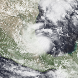
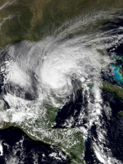
WHurricane Debby was the first hurricane to strike the Mexican state of Veracruz since Hurricane Anna in 1956. The eighth tropical cyclone, fourth named storm, and the first hurricane of the 1988 Atlantic hurricane season, Debby developed from a tropical wave off the west coast of the Yucatan Peninsula on August 31. The system slowly intensified as it tracked west-northwestward toward Mexico, eventually reaching tropical storm status on September 2. Thereafter, Debby began to rapidly strengthen, and the storm was upgraded to a hurricane later that day. After attaining peak winds of 75 mph (120 km/h), Debby made landfall near Tuxpan, Veracruz, in Mexico early on September 3. The hurricane quickly weakened inland, but managed to reach the eastern Pacific on September 5. Debby became Tropical Depression Seventeen-E, which moved northwest but remained poorly organized due to wind shear and dissipated on September 8.
 W
WTropical Cyclone Filao was a moderately intense tropical cyclone that caused widespread flooding in Mozambique in 1988. First classified as a tropical depression north of Madagascar, the system moved southwest, crossing the northern part of the nation before entering the Mozambique Channel on February 27, where it began to deepen. Later that day, the depression was upgraded into a moderate tropical storm. Two days later, Filao attained severe tropical storm intensity as it began to stall. On March 1, the storm reached cyclone intensity just before turning west. Later that day, Filao attained peak intensity, with winds of 135 km/h (85 mph) and a minimum barometric pressure of 954 mbar (hPa); 28.17 inHg. Within 24 hours, however, the system moved ashore near Quelimane in Central Mozambique, and several hours later, Filao dissipated inland.
 W
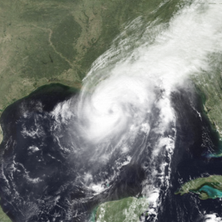
WHurricane Florence was the third of four named tropical cyclones to make landfall on the United States during the 1988 Atlantic hurricane season. The seventh tropical storm and second hurricane of the season, Florence developed on September 7 from an area of convection associated with a dissipating frontal trough in the southern Gulf of Mexico. After initially moving eastward, the storm turned northward and strengthened. Florence reached hurricane status and later peak winds of 80 mph (130 km/h) on September 9 shortly before striking southeastern Louisiana. The storm rapidly weakened over land and dissipated on September 11 over northeastern Texas.
 W
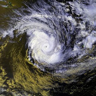
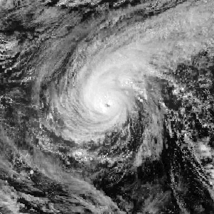
WHurricane Gilbert was the second most intense tropical cyclone on record in the Atlantic basin in terms of barometric pressure, only behind Hurricane Wilma in 2005. An extremely powerful tropical cyclone that formed during the 1988 Atlantic hurricane season, Gilbert peaked as a Category 5 strength hurricane that brought widespread destruction to the Caribbean and the Gulf of Mexico, and is tied with 1969's Hurricane Camille as the second-most intense tropical cyclone to make landfall in the Atlantic Ocean. Gilbert was also one of the largest tropical cyclones ever observed in the Atlantic basin. At one point, its tropical storm-force winds measured 575 mi (925 km) in diameter. In addition, Gilbert was the most intense tropical cyclone in recorded history to strike Mexico. Gilbert is also
 W
WSevere Tropical Cyclone Ilona caused moderate damage across the Pilbara region of Western Australia in mid-December 1988. The system originated from a monsoon trough that coalesced into a tropical low over the Timor Sea on 12 December. The system initially moved southwest, before moving on a more westerly course. Steady intensification occurred and Ilona reached its peak strength on 17 December as a low-end severe tropical cyclone. A southward turn directed the cyclone toward Western Australia, and it made landfall near Mardie Station. The system subsequently degraded over land and dissipated on 19 December.
 W
WHurricane Joan was a long lived, powerful hurricane that caused death and destruction in over a dozen countries in the Caribbean and Central America. Moving on a due west course for nearly two weeks in October 1988, Hurricane Joan caused widespread flooding and over 200 deaths after moving into Central America. Widespread suffering and economic crises were exacerbated by Joan, primarily across Nicaragua, as heavy rains and high winds impacted those near the hurricane's path.
 W
WTropical Storm Keith was the eleventh Atlantic tropical cyclone of the 1988 Atlantic hurricane season. It struck the Continental United States later in the calendar year than any since the 1925 Atlantic hurricane season. Keith developed out of a tropical wave in the Caribbean Sea on November 17. It tracked northwestward, and under generally favorable conditions, it reached a peak intensity of 70 mph (110 km/h) shortly before striking the northeastern tip of the Yucatán Peninsula. It turned northeastward in the Gulf of Mexico, and made landfall near Sarasota, Florida, on November 23. Keith accelerated its forward motion under the influence of a cold front, and became extratropical near Bermuda on November 24. The extratropical remnant persisted for two more days.
 W
WTyphoon Roy, known in the Philippines as Typhoon Asiang, was the second-most intense January tropical cyclone on record in the Western Pacific basin. Forming out of an area of disturbed weather on January 7, 1988, Roy quickly intensified as it moved through the Marshall Islands. By January 9, the storm intensified into a typhoon and attained its peak intensity the following day. At its peak, sustained winds reached 215 km/h (135 mph). Slight weakening took place before the storm moved through the Mariana Islands. Continuing westward, the system eventually struck the Philippines as a minimal typhoon before dissipating over the South China Sea on January 19.
 W
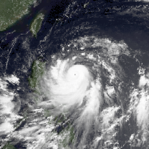
WTyphoon Ruby, known in the Philippines as Typhoon Unsang, was the strongest typhoon to strike the Philippines in 18 years. The tenth typhoon of the 1988 Pacific typhoon season, Ruby formed from an area of low pressure situated east of the Philippines on October 20. The storm steadily intensified as it moved west, and then west-northwest. After developing an eye, Ruby attained typhoon intensity on October 23 and began to strengthen at a brisker clip. Ruby reached maximum intensity later that day, before moving ashore along the central portion of Luzon early on October 24. The storm steadily weakened over land and this trend only continued after Ruby entered the South China Sea. On October 27, Ruby made a second landfall as a tropical storm on Hainan Island before dissipating the next day.
 W
WTyphoon Skip, known in the Philippines as Typhoon Yoning, was the final of three tropical cyclones in 1988 to directly impact the Philippines in a two-week time frame. Several areas of disturbed weather developed within the monsoon trough around November 1. One area situated to the south of Guam gradually became better organized, and by late November 3, the system was upgraded into a tropical depression, and a tropical storm later that day. Steady deepening ensued as Skip veered west and the cyclone was upgraded into a typhoon on November 5. The next day, Skip attained its maximum intensity of 145 km/h (90 mph). Shortly after its peak, weakening ensued as the storm tracked across the Philippines. This trend continued once the cyclone entered the South China Sea, initially as a severe tropical storm late on November 7. Slowing down in forward motion, Skip briefly turned west-northwest, then west and finally turned west-southwest before dissipating on November 12.
 W
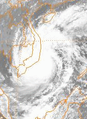
WTropical Storm Tess known in the Philippines as Tropical Storm Welpring was the second of three tropical cyclones to directly impact the Philippines in a two-week time frame in 1988. An area of disturbed weather near the Philippines was first observed on November 1. Following an increase in organization, the disturbance was designated as a tropical cyclone on November 4. Moving west, Tess steadily strengthened due to favorable conditions aloft. During the evening of November 5, Tess was estimated to have achieved its highest intensity, with winds of 115 km/h (70 mph). Rapid weakening then ensured as Tess neared Vietnam, and after making landfall in the country on November 6, Tess dissipated the next day.
 W
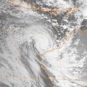
WHurricane Uleki, also referred as Typhoon Uleki, was a long-lived tropical cyclone in August–September 1988 that had minimal effects on land. Originating from a disturbance in the Intertropical Convergence Zone in late-August, Uleki was identified as a tropical depression well to the southeast of Hawaii on August 28. Steady organization ensued as it moved west, becoming a tropical storm on August 30 and a hurricane on August 31. Rapid intensification took place thereafter and the storm reached its peak intensity on September 2 as a Category 3 on the Saffir–Simpson hurricane wind scale. Hurricane Hunters investigating the cyclone found peak winds of 125 mph (205 km/h) and a barometric pressure of 957 mbar. Thereafter, Uleki stalled for two days to the southwest of Hawaii, resulting in heavy surf across the state. The dangerous swells killed two people on Oahu.
 W
WTyphoon Warren, known in the Philippines as Typhoon Huaning, struck the Philippines and China during July 1988. An area of disturbed weather developed within the vicinity of the Caroline Islands during the second week of July. A tropical depression developed southeast of Guam on July 12, and on the next day, intensified into a tropical storm. Tracking generally west-northwest, Warren deepened into a typhoon on July 14. The storm subsequently entered a period of rapid intensification, commencing with Warren reaching its highest intensity on July 16. The following evening, the typhoon brushed Luzon, resulting in a weakening trend, although Warren was still a typhoon when it made landfall near Shantou. Warren rapidly dissipated inland.