 W
WTropical Depression Twelve-E was a short-lived but deadly tropical cyclone that dropped heavy rainfall across large portions of Central America in October 2011. It formed from a tropical disturbance roughly hundred miles south of Mexico, which fluctuated in organization for several days. By October 12, the National Hurricane Center (NHC) deemed the associated low pressure-area well defined enough for it to be considered a tropical depression. After attaining peak wind speeds of 35 mph (55 km/h), the depression moved ashore between Salina Cruz, Oaxaca, and Arriaga, Chiapas. It caused significant flooding and at least 30 fatalities in the region.
 W
WThe 1906 Florida Keys hurricane was a powerful and deadly hurricane that had a major impact on Cuba and southern Florida. The fifth hurricane and third major hurricane of the season, the storm formed from a system near Barbados on October 4. By October 8, it had intensified into a tropical storm, and made landfall as a hurricane in Central America. The hurricane traveled towards Cuba, making landfall and wreaking havoc on the island. The storm then made a third landfall in the Florida Keys during the evening of October 18. At least 240 people were killed as a result of the hurricane, and damages totaled at least $4,135,000.
 W
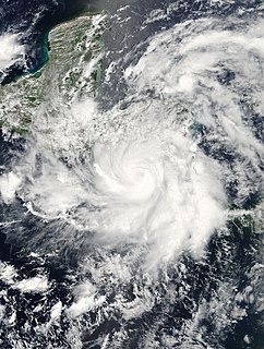
WTropical Storm Agatha was a weak but catastrophic tropical cyclone that brought widespread floods to much of Central America, and was the deadliest tropical cyclone in the eastern Pacific since Hurricane Pauline in 1997. The first storm of the 2010 Pacific hurricane season, Agatha originated from the Intertropical Convergence Zone, a region of thunderstorms across the tropics. It developed into a tropical depression on May 29 and tropical storm later, it was dissipated on May 30, reaching top winds of 45 mph and a lowest pressure of 1000 mbar. It made landfall near the Guatemala–Mexico border on the evening of May 29. Agatha produced torrential rain all across Central America, which resulted in the death of one person in Nicaragua. In Guatemala, 152 people were killed and 100 left missing by landslides. Thirteen deaths also occurred in El Salvador. Agatha soon dissipated over Guatemala. As of June 15, officials in Guatemala have stated that 165 people were killed and 113 others are missing.
 W
WTropical Storm Aletta was a weak but destructive tropical storm that killed 308 people while meandering off the coast of Central America in May 1982. An area of disturbed weather developed into a tropical depression on May 20, and into a tropical storm around noon on May 21. The cyclone turned northeast, reaching its peak as a strong tropical storm on May 23. Aletta meandered and gradually weakened, dissipating a few hundred miles southwest of Acapulco on May 29. Moisture from the tropical system spread over Honduras and Nicaragua, causing flooding. Throughout the two countries, 308 people were killed and total damage was at $466 million (1982 USD). In the aftermath of the storm, many programs provided relief to the victims of Aletta.
 W
WTropical Storm Alma of the 2008 Pacific hurricane season was the easternmost forming Pacific tropical cyclone on record. It formed within the monsoon trough just off the coast of Costa Rica on May 29. Initially forecast to remain a weak tropical storm, the cyclone rapidly strengthened and developed an eye before making landfall in Nicaragua near León with peak winds of 65 mph (100 km/h). Alma was the first tropical storm on record to strike the Pacific coast of Nicaragua. In Costa Rica, heavy rainfall caused flooding and landslides, killing two and causing $35 million (USD) in damage. Three people were killed in Nicaragua, one from drowning and two others from electrocution. Five others died in Honduras from an aviation accident likely related to the storm and one other was swept away in floodwaters.
 W
WTropical Storm Andres is one out of two tropical cyclones on record to strike El Salvador. The first named storm of the active 1997 Pacific hurricane season, Andres formed on June 1 off the coast of Mexico. It initially moved toward the coast, although a change in steering winds turned the storm toward Mexico and Guatemala. After passing just offshore, Andres again changed direction toward the southeast, gradually weakening in the process. On June 7, it turned toward and hit El Salvador before dissipating. The storm brought rainfall to coastlines along much of its path, destroying some houses and inflicted damage. Two fishermen were reported missing in Nicaragua due to high seas, and there were four deaths in El Salvador.
 W
WTropical Storm Bret was the deadliest natural disaster in Venezuela since the 1967 Caracas earthquake. The third tropical cyclone of 1993 Atlantic hurricane season, Bret formed on August 4 from a westward-moving, African tropical wave. Bret would later peak as a 60 mph (95 km/h) tropical storm as it neared Trinidad. It took an extremely southerly course through the Caribbean, passing over the coasts of Venezuela and Colombia. High terrain in the northern parts of those countries severely disrupted the circulation of the storm, and Bret had weakened to a tropical depression before emerging over the extreme southwestern Caribbean Sea. There, it restrengthened to a tropical storm and made landfall in Nicaragua on August 10, dissipating soon after. Bret's remnants reached the Pacific Ocean, where they ultimately became Hurricane Greg.
 W
WHurricane Cesar–Douglas was one of the few tropical cyclones to survive the crossover from the Atlantic to east Pacific basin, and was the last to receive two names upon doing so. Hurricane Cesar was the third named storm and second hurricane of the 1996 Atlantic hurricane season. The system formed in the southern Caribbean Sea and affected several countries in South America before crossing Nicaragua and entering the Eastern Pacific where it was renamed Hurricane Douglas, the fourth named storm, third hurricane, and first and strongest major hurricane of the 1996 Pacific hurricane season. The storm killed 113 people in Central and South America and left 29 others missing, mainly due to flooding and mudslides.
 W
WHurricane Felix was the southernmost landfalling Category 5 hurricane in the Atlantic, surpassing Hurricane Edith of 1971. It was the sixth named storm, second hurricane, and second Category 5 hurricane of the 2007 Atlantic hurricane season. Felix formed from a tropical wave on August 31, passing through the southern Windward Islands on September 1 before strengthening to attain hurricane status. On the next day, Felix rapidly strengthened into a major hurricane, and early on September 3 it was upgraded to Category 5 status; at 2100 UTC on the same day, the hurricane was downgraded to Category 4 status, but strengthened into a Category 5 hurricane for the second and final time by the morning of September 4.
 W
WHurricane Gert was a large tropical cyclone that caused extensive flooding and mudslides throughout Central America and Mexico in September 1993. The seventh named storm and third hurricane of the annual hurricane season, Gert originated as a tropical depression from a tropical wave over the southwestern Caribbean Sea on September 14. The next day, the cyclone briefly attained tropical storm strength before moving ashore in Nicaragua and proceeding through Honduras. It reorganized into a tropical storm over the Gulf of Honduras on September 17, but weakened back to a depression upon crossing the Yucatán Peninsula. Once over the warm waters of the Bay of Campeche, Gert quickly strengthened into a Category 2 hurricane by September 20. The hurricane made a final landfall on the Gulf Coast of Mexico near Tuxpan, Veracruz, with peak winds of 100 mph (155 km/h). The rugged terrain disrupted the cyclone's structure; Gert entered the Pacific Ocean as a depression near the state of Nayarit on September 21, where it briefly redeveloped a few strong thunderstorms before dissipating at sea five days later.
 W
WHurricane Greta, later Hurricane Olivia, was one of ten named Atlantic hurricanes to cross over Central America into the eastern Pacific while remaining a tropical cyclone. The seventh named storm of the 1978 Atlantic hurricane season, Greta formed from a tropical wave just northwest of Trinidad on September 13, and despite being in a climatologically unfavorable area, gradually intensified while moving west-northwestward. On September 16, it became a hurricane south of Jamaica. Two days later, the well-defined eye approached northeastern Honduras but veered to the northwest. After reaching peak winds of 130 mph (215 km/h) that day, Greta weakened while paralleling the northern Honduras coast just offshore. On September 19, it made landfall on Belize near Dangriga and quickly weakened into a tropical depression while crossing Guatemala and southeastern Mexico. After entering the eastern Pacific, the system re-intensified into a hurricane and was renamed Olivia, the eighteenth named storm of the 1978 Pacific hurricane season which weakened before landfall and dissipated over Chiapas on September 23.
 W
WHurricane Anna impacted Central America and the Windward Islands in July 1961. The first tropical cyclone and first hurricane of the hurricane season, Anna developed on July 20 from an easterly wave located in the Intertropical Convergence Zone (ITCZ) over the Windward Islands. Initially a tropical storm, it moved westward across the Caribbean Sea. Favorable environmental conditions allowed Anna to reach hurricane intensity late on July 20. Early on the following day, the storm strengthened into a Category 2 hurricane on the modern-day Saffir–Simpson hurricane wind scale. Intensification continued, and on July 22, Anna peaked with maximum sustained winds of 105 mph (165 km/h). The hurricane then weakened slightly while approaching the coast of Honduras. Further weakening occurred; when Anna made landfall in landfall in Belize on July 24, winds decreased to 80 mph (130 km/h). Anna rapidly weakened over land and dissipated later that day.
 W
WHurricane Sandra was the latest-forming major hurricane in the northeastern Pacific basin, the strongest November Pacific hurricane on record, and the record eleventh major hurricane of the 2015 Pacific hurricane season. Originating from a tropical wave, Sandra was first classified as a tropical depression on November 23 well south of Mexico. Environmental conditions, including high sea surface temperatures and low wind shear, were highly conducive to intensification and the storm quickly organized. A small central dense overcast developed atop the storm and Sandra reached hurricane status early on November 25 after the consolidation of an eye. Sandra reached its peak intensity as a Category 4 hurricane on the Saffir–Simpson hurricane wind scale with winds of 150 mph (240 km/h) and a pressure of 934 mbar early on November 26. Thereafter, increasing shear degraded the hurricane's structure and weakening ensued. Rapid weakening took place on November 27 and Sandra's circulation became devoid of convection as it diminished to a tropical storm that evening. The cyclone degenerated into a remnant low soon thereafter and ultimately dissipated just off the coast of Sinaloa, Mexico, on November 29.
 W
WNicaragua, officially the Republic of Nicaragua, is the largest country in the Central American isthmus, bordered by Honduras to the northwest, the Caribbean to the east, Costa Rica to the south, and the Pacific Ocean to the southwest. Tropical cyclones are common in the country, with an average of one storm a year. The coast is especially subject to destructive tropical storms and hurricanes, particularly from July through October. The high winds and floods, accompanying these storms often cause considerable destruction of property. Hurricanes or heavy rains in the central highlands where agriculture has destroyed much of the natural vegetation also cause considerable crop damage and soil erosion. One of the deadliest hurricanes to hit Nicaragua has been Hurricane Mitch in 1998, in which the storm killed thousands in the country.
 W
WHurricane Ida was the strongest landfalling tropical cyclone during the 2009 Atlantic hurricane season, crossing the coastline of Nicaragua with winds of 80 mph (130 km/h). The remnants of the storm became a powerful nor'easter that caused widespread damage along coastal areas of the Mid-Atlantic States. Ida formed on November 4 in the southwestern Caribbean, and within 24 hours struck the Nicaragua coast with winds of 80 mph (130 km/h). It weakened significantly over land, although it restrengthened in the Yucatán Channel to peak winds of 105 mph (165 km/h). Hurricane Ida weakened and became an extratropical cyclone in the northern Gulf of Mexico before spreading across the southeastern United States. The remnants of Ida contributed to the formation of a nor'easter that significantly affected the eastern coast of the United States.
 W
WHurricane Irene–Olivia was the first actively tracked tropical cyclone to move into the eastern Pacific Ocean from the Atlantic basin. It originated as a tropical depression on September 11, 1971, in the tropical Atlantic. The cyclone tracked nearly due westward at a low latitude, passing through the southern Windward Islands and later over northern South America. In the southwest Caribbean Sea, it intensified to a tropical storm and later a hurricane. Irene made landfall on southeastern Nicaragua on September 19, and maintained its circulation as it crossed the low-lying terrain of the country. Restrengthening after reaching the Pacific, Irene was renamed Hurricane Olivia, which ultimately attained peak winds of 115 mph (185 km/h). Olivia weakened significantly before moving ashore on the Baja California Peninsula on September 30; the next day it dissipated.
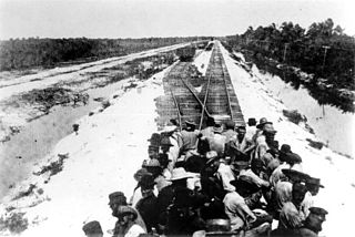
WHurricane Joan was a long lived, powerful hurricane that caused death and destruction in over a dozen countries in the Caribbean and Central America. Moving on a due west course for nearly two weeks in October 1988, Hurricane Joan caused widespread flooding and over 200 deaths after moving into Central America. Widespread suffering and economic crises were exacerbated by Joan, primarily across Nicaragua, as heavy rains and high winds impacted those near the hurricane's path.
 W
WTropical Storm Katrina was a short-lived, weak tropical cyclone that produced minor damage across areas previously devastated by Hurricane Mitch in 1998. Forming out of a broad area of low pressure in the southwestern Caribbean Sea on October 28, 1999, the disorganized tropical storm made landfall near Puerto Cabezas, Nicaragua with winds of 40 mph (65 km/h) on October 30 before weakening to a tropical depression. The remnants of the storm persisted until November 1, at which time it was absorbed by a cold front on the northern end of the Yucatán Peninsula.
 W
WHurricane Martha was the only known tropical cyclone to make landfall in Panama. The eighteenth named storm and twelfth hurricane of the 1969 Atlantic hurricane season, Martha developed in the southwestern Caribbean Sea on November 21. Initially, the storm developed with sustained winds of 50 mph (85 km/h), skipping tropical depression status. It remained stationary and quickly intensified into a hurricane. Martha attained maximum sustained winds of 90 mph (150 km/h) on November 22. Subsequently, Martha weakened and drifted southward. On November 24, Martha made landfall in Veraguas Province, Panama, as a strong tropical storm. The system weakened to a tropical depression and dissipated over land on November 25.
 W
WHurricane Michael was a very powerful and destructive tropical cyclone that became the first Category 5 hurricane to strike the contiguous United States since Andrew in 1992. In addition, it was the third-most intense Atlantic hurricane to make landfall in the contiguous United States in terms of pressure, behind the 1935 Labor Day hurricane and Hurricane Camille in 1969. It was the first Category 5 hurricane on record to impact the Florida Panhandle, the fourth-strongest landfalling hurricane in the contiguous United States, in terms of wind speed, and the most intense hurricane on record to strike the United States in the month of October.
 W
WHurricane Mitch is the second-deadliest Atlantic hurricane on record, causing over 11,000 fatalities in Central America in 1998, including approximately 7,000 in Honduras and 3,800 in Nicaragua due to catastrophic flooding from the slow motion of the storm. It was the deadliest hurricane in Central American history, surpassing Hurricane Fifi–Orlene, which killed slightly fewer people there in 1974.
 W
WHurricane Nate was the costliest natural disaster in Costa Rican history. An unusually fast-moving tropical cyclone, it caused severe flooding in Central America, leading to widespread destruction and casualties, during early October 2017, before making landfall on the US Gulf Coast. The fourteenth named storm and ninth hurricane of the hyperactive 2017 Atlantic hurricane season, Nate originated from a broad area of low pressure over the southwestern Caribbean on October 3. The disturbance moved northwest, organizing into a tropical depression the next day and attaining tropical storm intensity early on October 5. The storm moved ashore the coastline of Nicaragua thereafter. Little change in strength occurred as the system continued into Honduras, and Nate began steady intensification over the warm waters of the northwestern Caribbean Sea shortly thereafter. It attained hurricane strength while moving through the Yucatán Channel early on October 7, attaining peak winds of 90 mph (150 km/h) in the central Gulf of Mexico later that day. Early on the next day, Nate made landfall near the mouth of the Mississippi River in Louisiana. After crossing the marshland of the Mississippi Delta, it made its second U.S. landfall near Biloxi, Mississippi early on October 8, causing a storm surge to flood the ground floor of coastal casinos and buildings, as well as causing rip currents, hurricane-force winds, and beach erosion.
 W
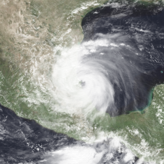
WHurricane Otto was the first tropical cyclone since Hurricane Cesar–Douglas in 1996 to survive the crossover from the Atlantic Ocean to the Pacific Ocean. Forming late on November 20 in the southwestern Caribbean Sea, Otto was the fifteenth and final named storm, seventh hurricane and fourth major hurricane of the 2016 Atlantic hurricane season. It quickly intensified into a strong tropical storm the next day, and on November 23–24, rapidly strengthened into a Category 3 major hurricane, the first in the month of November since Hurricane Paloma in 2008, and the latest date an Atlantic hurricane attained such intensity on record. Otto made landfall in Nicaragua at peak intensity on November 24, thus becoming the latest hurricane to make landfall in the Atlantic basin since 1851 when records began. Traveling along the Nicaragua–Costa Rica border, the system rapidly weakened to a tropical storm before emerging over the eastern Pacific Ocean, becoming the final storm of the 2016 Pacific hurricane season as well. Hostile environmental conditions inhibited reorganization, and Otto subsequently degenerated into an elongated trough on November 26.
 W
WHurricane Patricia was an exceptionally powerful tropical cyclone that became the strongest on record worldwide in terms of wind speed and the second-most intense on record worldwide in terms of pressure, behind Typhoon Tip in 1979, with a minimum atmospheric pressure of 872 mbar. Originating from a sprawling disturbance near the Gulf of Tehuantepec, south of Mexico, in mid-October 2015, Patricia was first classified a tropical depression on October 20. Initial development was slow, with only modest strengthening within the first day of its classification. The system later became a tropical storm and was named Patricia, the twenty-fourth named storm of the annual hurricane season. Exceptionally favorable environmental conditions fueled explosive intensification on October 22. A well-defined eye developed within an intense central dense overcast and Patricia grew from a tropical storm to a Category 5 hurricane in just 24 hours—a near-record pace. On October 23, the hurricane achieved its record peak intensity with maximum sustained winds of 215 mph (345 km/h). This made it the most intense tropical cyclone on record in the Western Hemisphere and the strongest globally in terms of one-minute maximum sustained winds.
 W
WHurricane Paula was a small hurricane that struck Honduras and Cuba in October 2010. The eighteenth tropical cyclone, sixteenth named storm, and ninth hurricane of the season, Paula developed from a low pressure area over the southwestern Caribbean Sea on October 11. Moving northwestward, it slowly organized and was upgraded to a tropical storm shortly thereafter. Around midday on October 11, Paula made landfall near Cabo Gracias a Dios at the border of Honduras and Nicaragua. In northeastern Honduras, strong winds destroyed several homes, while rainfall destroyed a few roads and dozens of buildings, include a school and a police station. Favorable conditions such as low wind shear and warm sea surface temperatures allowed Paula to reach hurricane status early on October 12. Further intensification occurred, and the storm peaked with winds of 105 mph (165 km/h) while curving northward on October 13.
 W
WHurricane Rina was a powerful and slow-moving tropical cyclone that caused minor impacts in the northwestern Caribbean Sea in late October 2011. The seventeenth named storm, seventh hurricane, and fourth major hurricane of the annual hurricane season, Rina developed from a tropical wave in the western Caribbean on October 23. The depression quickly intensified, and was upgraded to Tropical Storm Rina early on the following day. Further strengthening ensued as it tracked west-northwestward, with Rina becoming a hurricane on October 24. The hurricane eventually peaked as a Category 3 hurricane while it moved generally westward on October 25. However, on October 26, Rina weakened substantially and was downgraded to a Category 1 hurricane. Further weakening occurred, with Rina falling to tropical storm intensity on October 27. Rina then made landfall in northern Quintana Roo early the next day. The cyclone degenerated into a remnant low later on October 28 after emerging into the Yucatán Channel. The low dissipated near the western tip of Cuba on October 29.
 W
WHurricane Beta was a compact and intense tropical cyclone that impacted the southwestern Caribbean in late October 2005. Beta was the twenty-fourth tropical storm, fourteenth hurricane, and seventh and final major hurricane of the record-breaking 2005 Atlantic hurricane season. On October 21, a developing tropical wave entered the eastern Caribbean Sea and spawned Tropical Storm Alpha the following day. As the wave entered the southwestern Caribbean, convection redeveloped and on October 26, the system spawned another low-pressure area which developed into Tropical Depression Twenty-six. The depression intensified into a tropical storm the next morning and was named Beta. By the morning of October 28, the storm intensified into a hurricane, the fourteenth of the season. Beta underwent rapid intensification for several hours to attain its peak intensity with winds of 115 mph (185 km/h) on October 30. The storm began to deteriorate before landfall, weakening to Category 2 status as it crossed the Nicaraguan coastline. Rapid weakening followed landfall, and the storm dissipated early the next morning.
 W
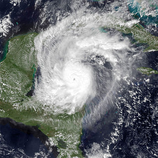
WHurricane Eta was a devastating Category 4 hurricane that wreaked havoc across parts of Central America in early November 2020. The record-tying twenty-eighth named storm, twelfth hurricane and fifth major hurricane of the extremely active 2020 Atlantic hurricane season, Eta originated from a vigorous tropical wave in the eastern Caribbean Sea on October 31. The system rapidly organized as it progressed west, with the cyclone ultimately becoming a Category 4 hurricane on November 3. With a peak intensity of 150 mph (240 km/h) and 923 mbar, it was the third most intense November Atlantic hurricane on record, behind the 1932 Cuba hurricane, and Hurricane Iota just two weeks later. Some weakening took place as the system made landfall near Puerto Cabezas, Nicaragua, late that same day. Eta rapidly weakened to a tropical depression as it meandered across Central America for two days before moving north over water. It later reorganized over the Caribbean as it accelerated toward Cuba on November 7. Over the next five days, the system moved erratically, moving through the Florida Keys and stalling in the southern Gulf of Mexico, its intensity fluctuating along the way. After briefly regaining hurricane strength it weakened once more and accelerated across the Southeastern United States on November 12. It soon became extratropical and dissipated off the Eastern United States the next day.
 W
WHurricane Iota was the latest Atlantic hurricane to attain Category 5 intensity and only the second Category 5 Atlantic hurricane to occur within the month of November on record—the other being the 1932 Cuba hurricane. Iota caused severe damage to areas of Central America already devastated by Hurricane Eta just less than two weeks prior. The 31st and final tropical cyclone, 30th named storm, 13th hurricane, and sixth major hurricane of the record-breaking 2020 Atlantic hurricane season, Iota originated as a tropical wave that moved into the Eastern Caribbean on November 10. Over the next few days, the wave began to become better organized and by November 13, it developed into a tropical depression north of Colombia. The depression strengthened into Tropical Storm Iota six hours later. The storm was initially impacted by some wind shear, but a center relocation and relaxed shear allowed Iota to quickly strengthen into a hurricane on November 15, after which it underwent explosive intensification, becoming a Category 5 hurricane the following day. This made 2020 the fifth consecutive Atlantic hurricane season since 2016 to feature at least one Category 5 hurricane. After weakening slightly, Iota made landfall in northeastern Nicaragua as a high-end Category 4 hurricane, becoming the strongest recorded hurricane to make landfall in Nicaragua in November. Iota then rapidly weakened as it moved inland, dissipating on November 18.