 W
WThe AERMOD atmospheric dispersion modeling system is an integrated system that includes three modules:
 W
WThe Arakawa grid system depicts different ways to represent and compute orthogonal physical quantities on rectangular grids used for Earth system models for meteorology and oceanography. For example, the Weather Research and Forecasting Model uses the Arakawa Staggered C-Grid in its atmospheric calculations when using the ARW core. The five Arakawa grids (A-E) were first introduced in Arakawa and Lamb 1977.
 W
WAn atmospheric model is a mathematical model constructed around the full set of primitive dynamical equations which govern atmospheric motions. It can supplement these equations with parameterizations for turbulent diffusion, radiation, moist processes, heat exchange, soil, vegetation, surface water, the kinematic effects of terrain, and convection. Most atmospheric models are numerical, i.e. they discretize equations of motion. They can predict microscale phenomena such as tornadoes and boundary layer eddies, sub-microscale turbulent flow over buildings, as well as synoptic and global flows. The horizontal domain of a model is either global, covering the entire Earth, or regional (limited-area), covering only part of the Earth. The different types of models run are thermotropic, barotropic, hydrostatic, and nonhydrostatic. Some of the model types make assumptions about the atmosphere which lengthens the time steps used and increases computational speed.
 W
WThe carbon cycle is the biogeochemical cycle by which carbon is exchanged among the biosphere, pedosphere, geosphere, hydrosphere, and atmosphere of the Earth. Carbon is the main component of biological compounds as well as a major component of many minerals such as limestone. Along with the nitrogen cycle and the water cycle, the carbon cycle comprises a sequence of events that are key to make Earth capable of sustaining life. It describes the movement of carbon as it is recycled and reused throughout the biosphere, as well as long-term processes of carbon sequestration to and release from carbon sinks. Carbon sinks in the land and the ocean each currently take up about one-quarter of anthropogenic carbon emissions each year.
 W
WClimate change mitigation consists of actions to limit the magnitude or rate of global warming and its related effects. This generally involves reductions in human emissions of greenhouse gases (GHGs).
 W
WNumerical climate models use quantitative methods to simulate the interactions of the important drivers of climate, including atmosphere, oceans, land surface and ice. They are used for a variety of purposes from study of the dynamics of the climate system to projections of future climate. Climate models may also be qualitative models and also narratives, largely descriptive, of possible futures.
 W
WContour advection is a Lagrangian method of simulating the evolution of one or more contours or isolines of a tracer as it is stirred by a moving fluid. Consider a blob of dye injected into a river or stream: to first order it could be modelled by tracking only the motion of its outlines. It is an excellent method for studying chaotic mixing: even when advected by smooth or finitely-resolved velocity fields, through a continuous process of stretching and folding, these contours often develop into intricate fractals. The tracer is typically passive as in but may also be active as in, representing a dynamical property of the fluid such as vorticity. At present, advection of contours is limited to two dimensions, but generalizations to three dimensions are possible.
 W
WCyclonic Niño is a climatological phenomenon that has been observed in climate models where tropical cyclone activity is increased. Increased tropical cyclone activity mixes ocean waters, introducing cooling in the upper layer of the ocean that quickly dissipates and warming in deeper layers that lasts considerably more, resulting in a net warming of the ocean.
 W
WThe Earth Simulator (ES) , developed by the Japanese government's initiative "Earth Simulator Project", was a highly parallel vector supercomputer system for running global climate models to evaluate the effects of global warming and problems in solid earth geophysics. The system was developed for Japan Aerospace Exploration Agency, Japan Atomic Energy Research Institute, and Japan Marine Science and Technology Center (JAMSTEC) in 1997. Construction started in October 1999, and the site officially opened on 11 March 2002. The project cost 60 billion yen.
 W
WThe Educational Global Climate Model or EdGCM is a fully functional global climate model (GCM) that has been ported for use on desktop computers. It operates through a graphical user interface and is integrated with a relational database and scientific visualization utilities, all of which aim at helping improve the quality of teaching and understanding of climatology by making real-world research experiences more accessible. EdGCM is designed to permit teachers and students to conduct in-depth investigations of past, present and future climate scenarios in a manner that is essentially identical to the techniques used by national and international climate research organizations.
 W
WEnsemble forecasting is a method used in or within numerical weather prediction. Instead of making a single forecast of the most likely weather, a set of forecasts is produced. This set of forecasts aims to give an indication of the range of possible future states of the atmosphere. Ensemble forecasting is a form of Monte Carlo analysis. The multiple simulations are conducted to account for the two usual sources of uncertainty in forecast models: (1) the errors introduced by the use of imperfect initial conditions, amplified by the chaotic nature of the evolution equations of the atmosphere, which is often referred to as sensitive dependence on initial conditions; and (2) errors introduced because of imperfections in the model formulation, such as the approximate mathematical methods to solve the equations. Ideally, the verified future atmospheric state should fall within the predicted ensemble spread, and the amount of spread should be related to the uncertainty (error) of the forecast. In general, this approach can be used to make probabilistic forecasts of any dynamical system, and not just for weather prediction.
 W
WThe Environmental Modeling Center (EMC) is a United States Government agency, which improves numerical weather, marine and climate predictions at the National Centers for Environmental Prediction (NCEP), through a broad program of research in data assimilation and modeling. In support of the NCEP operational forecasting mission, the EMC develops, improves and monitors data assimilation systems and models of the atmosphere, ocean and coupled system, using advanced methods developed internally as well as cooperatively with scientists from universities, NOAA laboratories and other government agencies, and the international scientific community.
 W
WThe Finite Volume Community Ocean Model is a prognostic, unstructured-grid, free-surface, 3-D primitive equation coastal ocean circulation model. The model is developed primarily by researchers at the University of Massachusetts Dartmouth and Woods Hole Oceanographic Institution, and used by researchers worldwide. Originally developed for the estuarine flooding/drying process, FVCOM has been upgraded to the spherical coordinate system for basin and global applications.
 W
WA geodesic grid is a spatial grid based on a geodesic polyhedron or Goldberg polyhedron.
 W
WA general circulation model (GCM) is a type of climate model. It employs a mathematical model of the general circulation of a planetary atmosphere or ocean. It uses the Navier–Stokes equations on a rotating sphere with thermodynamic terms for various energy sources. These equations are the basis for computer programs used to simulate the Earth's atmosphere or oceans. Atmospheric and oceanic GCMs are key components along with sea ice and land-surface components.
The Global Organization of Earth System Science Portals or (GO-ESSP) is an international collaboration, formed in 2003, that is developing software infrastructure to support the distribution, and analysis of climate model data and related observations.
 W
WThe International Comprehensive Ocean-Atmosphere Data Set (ICOADS) is a digital database of 261 million weather observations made by ships, weather ships, and weather buoys spanning the years 1662 to 2007. The database was initially constructed in 1985 and continues to be expanded upon and updated on a regular basis. From the original data, gridded datasets were created. ICOADS information has been useful in determining the reliability of ship and buoy wind measurements, helping to determine temperature trends in the sea surface temperature field, and updating the Atlantic hurricane database.
 W
WThe Mars general circulation model (MGCM) is the result of a research project by NASA to understand the nature of the general circulation of the atmosphere of Mars, how that circulation is driven and how it affects the climate of Mars in the long term.
 W
WThe Met Office Hadley Centre — named in honour of George Hadley — is one of the United Kingdom's leading centres for the study of scientific issues associated with climate change. It is part of, and based at the headquarters of the Met Office in Exeter.
 W
WMETRIC is a computer model developed by the University of Idaho, that uses Landsat satellite data to compute and map evapotranspiration (ET). METRIC calculates ET as a residual of the surface energy balance, where ET is estimated by keeping account of total net short wave and long wave radiation at the vegetation or soil surface, the amount of heat conducted into soil, and the amount of heat convected into the air above the surface. The difference in these three terms represents the amount of energy absorbed during the conversion of liquid water to vapor, which is ET. METRIC expresses near-surface temperature gradients used in heat convection as indexed functions of radiometric surface temperature, thereby eliminating the need for absolutely accurate surface temperature and the need for air-temperature measurements.
 W
WThe history of numerical weather prediction considers how current weather conditions as input into mathematical models of the atmosphere and oceans to predict the weather and future sea state has changed over the years. Though first attempted manually in the 1920s, it was not until the advent of the computer and computer simulation that computation time was reduced to less than the forecast period itself. ENIAC was used to create the first forecasts via computer in 1950, and over the years more powerful computers have been used to increase the size of initial datasets as well as include more complicated versions of the equations of motion. The development of global forecasting models led to the first climate models. The development of limited area (regional) models facilitated advances in forecasting the tracks of tropical cyclone as well as air quality in the 1970s and 1980s.
WNumerical weather prediction (NWP) uses mathematical models of the atmosphere and oceans to predict the weather based on current weather conditions. Though first attempted in the 1920s, it was not until the advent of computer simulation in the 1950s that numerical weather predictions produced realistic results. A number of global and regional forecast models are run in different countries worldwide, using current weather observations relayed from radiosondes, weather satellites and other observing systems as inputs.
 W
WOld Weather is an online weather data project that currently invites members of the public to assist in digitising weather observations recorded in US log books dating from the mid-19th century onwards. It is an example of citizen science that enlists members of the public to help in scientific research. It contributes to the Atmospheric Circulation Reconstructions over the Earth initiative. Data collected by Old Weather has been used by at least five different climate reanalysis projects, including HURDAT, SODA and ECMWF. In February 2013, the project was awarded the Royal Meteorological Society IBM Award for Meteorological Innovation that Matters.
 W
WPRECIS is developed at the Hadley Centre at the UK Met Office, PRECIS is a regional climate modelling system designed to run on a Linux-based PC. PRECIS can be applied to any area of the globe to generate detailed climate change projections.
Regional Ocean Modeling System (ROMS) is a free-surface, terrain-following, primitive equations ocean model widely used by the scientific community for a diverse range of applications. The model is developed and supported by researchers at the Rutgers University, University of California Los Angeles and contributors worldwide.
 W
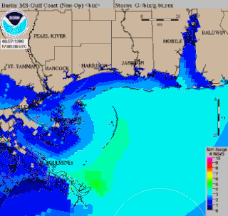
WSea, Lake, and Overland Surge from Hurricanes (SLOSH) is a computerized model developed by the Federal Emergency Management Agency (FEMA), United States Army Corps of Engineers (USACE), and the National Weather Service (NWS), to estimate storm surge depths resulting from historical, hypothetical, or predicted hurricanes. The model functions by taking into account a storm's pressure, size, forward speed, forecast track, wind speeds, and topographical data.
 W
WThe sigma coordinate system is a common coordinate system used in computational models for oceanography, meteorology and other fields where fluid dynamics are relevant. This coordinate system receives its name from the independent variable used to represent a scaled pressure level.
 W
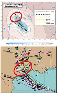
WA tropical cyclone forecast model is a computer program that uses meteorological data to forecast aspects of the future state of tropical cyclones. There are three types of models: statistical, dynamical, or combined statistical-dynamic. Ddual forecast model. Both consensus and superensemble forecasts can use the guidance of global and regional models runs to improve the performance more than any of their respective components. Techniques used at the Joint Typhoon Warning Center indicate that superensemble forecasts are a very powerful tool for track forecasting.
 W
WTropical cyclone track forecasting involves predicting where a tropical cyclone is going to track over the next five days, every 6 to 12 hours. The history of tropical cyclone track forecasting has evolved from a single-station approach to a comprehensive approach which uses a variety of meteorological tools and methods to make predictions. The weather of a particular location can show signs of the approaching tropical cyclone, such as increasing swell, increasing cloudiness, falling barometric pressure, increasing tides, squalls, and heavy rainfall.
 W
WIn computational science, wildfire modeling is concerned with numerical simulation of wildland fires in order to understand and predict fire behavior. Wildfire modeling can ultimately aid wildland fire suppression, namely increase safety of firefighters and the public, reduce risk, and minimize damage. Wildfire modeling can also aid in protecting ecosystems, watersheds, and air quality.