 W
WThe Great Hurricane of 1780, also known as Huracán San Calixto, the Great Hurricane of the Antilles, and the 1780 Disaster, is the deadliest Atlantic hurricane on record. An estimated 22,000 people died throughout the Lesser Antilles when the storm passed through them from October 10–16. Specifics on the hurricane's track and strength are unknown because the official Atlantic hurricane database only goes back to 1851.
 W
WThe 1899 San Ciríaco hurricane, also known as the 1899 Puerto Rico Hurricane or The Great Bahamas Hurricane of 1899, was the longest-lived Atlantic hurricane on record, and the second-longest-lived tropical cyclone globally on record after 1994's Hurricane John in the Pacific. It was also one of the deadliest Atlantic hurricanes in recorded history, with an estimated 3,800 fatalities. The third tropical cyclone and first major hurricane of the season, this storm was first observed southwest of Cape Verde on August 3. It slowly strengthened while heading steadily west-northwestward across the Atlantic Ocean and reached hurricane status by late on August 5. During the following 48 hours, it deepened further, reaching Category 4 on the modern day Saffir–Simpson hurricane wind scale (SSHWS) before crossing the Leeward Islands on August 7. Later that day, the storm peaked with winds of 150 mph (240 km/h). The storm weakened slightly before making landfall in Guayama, Puerto Rico with winds of 140 mph (220 km/h) on August 8. Several hours later, it emerged into the southwestern Atlantic as a Category 3 hurricane. The system paralleled the north coast of Dominican Republic and then crossed the Bahamas, striking several islands. Thereafter, it began heading northward on August 14, while centered east of Florida. Early on the following day, the storm re-curved northeastward and appeared to be heading out to sea. However, by August 17, it turned back to the northwest and made landfall near Hatteras, North Carolina early on the following day. No stronger hurricane has made landfall on the Outer Banks since the San Ciriaco hurricane.
 W
WThe Okeechobee hurricane of 1928, also known as the San Felipe Segundo hurricane, was one of the deadliest hurricanes in the recorded history of the North Atlantic basin, and the third deadliest hurricane in the United States, only behind the 1900 Galveston hurricane and Hurricane Maria. The hurricane killed an estimated 2,500 people in the United States; most of the fatalities occurred in the state of Florida, particularly in Lake Okeechobee. It was the fourth tropical cyclone, third hurricane, and only major hurricane of the year's hurricane season. It developed off the west coast of Africa on September 6 as a tropical depression, but it strengthened into a tropical storm later that day, shortly before passing south of the Cape Verde islands. Further intensification was slow and halted late on September 7. About 48 hours later, the storm strengthened and became a Category 1 hurricane on the Saffir–Simpson hurricane wind scale. Still moving westward, the system reached Category 4 intensity before striking Guadeloupe on September 12, where it brought great destruction and resulted in 1,200 deaths. The islands of Martinique, Montserrat, and Nevis also reported damage and fatalities, but not nearly as severe as in Guadeloupe.
 W
WHurricane Allen was a rare and extremely powerful Cape Verde hurricane that struck the Caribbean, eastern and northern Mexico, and southern Texas in August 1980. The first named storm and second tropical cyclone of the 1980 Atlantic hurricane season, it was the fifth most intense Atlantic hurricane on record in terms of barometric pressure, behind Hurricane Rita, the 1935 Labor Day hurricane, Hurricane Gilbert, and Hurricane Wilma. It was one of the few hurricanes to reach Category 5 status on the Saffir–Simpson Hurricane Scale on three occasions, and spent more time as a Category 5 than all but two other Atlantic hurricanes. Allen is the only hurricane in the recorded history of the Atlantic basin to achieve sustained winds of 190 mph (330 km/h), thus making it the strongest Atlantic hurricane by wind speed. Until Hurricane Patricia in 2015, these were also the highest sustained winds in the Western Hemisphere.
 W
WHurricane Baker was a Category 2 hurricane that affected the Leeward Islands, Greater Antilles, and the Gulf Coast of the United States. The tropical cyclone was the second tropical storm and second hurricane of the 1950 Atlantic hurricane season. Originating as a tropical depression east of the Windward Islands on August 18, Baker became a tropical storm on August 19, and further intensified into a hurricane on August 21. It attained an initial peak intensity with maximum sustained winds of 100 mph (155 km/h) on August 22 before weakening to a tropical storm as it made landfall on the island of Antigua. Baker weakened to a tropical depression late on August 23 while southwest of Puerto Rico. By the following morning, it had restrengthened into a tropical storm, though a landfall in Cuba caused it to weaken once again. Entering the Gulf of Mexico, Baker began to strengthen once more, regaining hurricane strength on August 29 and reaching its peak intensity with maximum sustained winds of 105 mph (165 km/h) early the following day. The cyclone weakened before making its final landfall in the United States near Gulf Shores, Alabama, with winds of 85 mph (140 km/h). Hurricane Baker produced extensive damage in the Lesser Antilles and Cuba, but impacts were minimal in the United States.
 W
WHurricane Bertha was an intense and early-forming major hurricane that affected areas from the Leeward Islands to the United States in July of the 1996 Atlantic hurricane season. The second named storm, first hurricane, and first major hurricane during the season. Bertha originated from a tropical wave that moved off the coast of Africa in early July. Steadily organizing while moving generally towards the west, the disturbance was designated as a tropical depression at 0000 UTC on July 5, and was further upgraded to a tropical storm by 1200 UTC later that day. Over the next few days, continued intensification occurred, and Bertha became a Category 1 hurricane on the Saffir-Simpson hurricane scale, the first hurricane of the season, prior to moving through the northern Leeward Islands. Late on July 8, a period of rapid intensification began, and at 0600 UTC on July 9, Bertha reached its peak intensity with maximum sustained winds of 115 mph (185 km/h) with a minimum barometric pressure of 960 mbar (28 inHg). Moving around the western periphery of the subtropical ridge, Bertha passed north of the Bahamas as a weakening hurricane before turning towards the north-northeast and undergoing another period of rapid intensification. Late on July 12, Bertha made landfall between Wrightsville Beach and Topsail Beach, North Carolina with winds of 105 mph (169 km/h). Gradual weakening ensued the following day as Bertha moved up the Mid-Atlantic and into New England before becoming an extratropical cyclone on July 14.
 W
WHurricane Betsy, known as Hurricane Santa Clara in Puerto Rico, was the first North Atlantic hurricane to make landfall in Puerto Rico in 24 years. The third tropical cyclone of the 1956 Atlantic hurricane season, Betsy developed from a tropical wave on August 9 to the east of the Lesser Antilles. It rapidly developed into a 120 mph (195 km/h) major hurricane before striking Guadeloupe. There, Betsy heavily damaged 1000 houses and left severe crop destruction, and there were 18 deaths in the territory. As Betsy continued into the northeastern Caribbean, it capsized a ship, killing its crew of two.
 W
WHurricane Cleo was the strongest tropical cyclone of the 1964 Atlantic hurricane season. It was the third named storm, first hurricane, and first major hurricane of the season. Cleo was one of the longest-lived storms of the season. This compact yet powerful hurricane travelled through the Caribbean Sea and later hit Florida before moving offshore Georgia into the Carolinas, killing 156 people and causing roughly $187 million in damage. Major damage was seen as far north as east-central Florida, with the heaviest rains falling along the immediate coast of the Southeast United States into southeast Virginia.
 W
WHurricane Danny in was the first major hurricane to develop between the Lesser Antilles and Western Africa since Hurricane Julia in 2010. The fourth tropical cyclone, and first hurricane of the 2015 Atlantic hurricane season, Danny originated from a well-defined tropical wave that emerged over the Atlantic Ocean on August 14. Traveling west, the system gradually coalesced into a tropical depression by August 18. After becoming a tropical storm later that day, dry air slowed further development. On August 20–21, dry air became removed from the system, and Danny rapidly intensified into a Category 3 hurricane on the Saffir–Simpson hurricane wind scale. Its peak was short-lived as wind shear soon increased and prompted significant weakening. Degrading to a tropical storm by August 23, Danny approached the Lesser Antilles. It degenerated into a tropical wave as it traversed the archipelago on August 24 and was last noted over Hispaniola the following day.
 W
WHurricane David was an extremely deadly hurricane which caused massive loss of life in the Dominican Republic in August 1979, and was the most intense hurricane to make landfall in the country in recorded history. A Cape Verde hurricane that reached Category 5 hurricane status on the Saffir-Simpson Hurricane Scale, David was the fourth named tropical cyclone, second hurricane, and first major hurricane of the 1979 Atlantic hurricane season, traversing through the Leeward Islands, Greater Antilles, and East Coast of the United States during late August and early September. David was the first hurricane to affect the Lesser Antilles since Hurricane Inez in 1966. With winds of 175 mph (280 km/h), David was the only storm of Category 5 intensity to make landfall on the Dominican Republic in the 20th century and the deadliest since the 1930 Dominican Republic Hurricane, San Zenon, killing over 2,000 people in its path. In addition, David was the deadliest Dominican tropical cyclone since the 1834 Padre Ruíz hurricane, which killed over 200 people.
 W
WHurricane Dean was the strongest tropical cyclone of the 2007 Atlantic hurricane season. It was the most intense North Atlantic hurricane since Hurricane Wilma of 2005, tying for eighth overall. Additionally, it made the fourth most intense Atlantic hurricane landfall. A Cape Verde hurricane that formed on August 13, 2007, Dean took a west-northwest path from the eastern Atlantic Ocean through the Saint Lucia Channel and into the Caribbean. It strengthened into a major hurricane, reaching Category 5 status on the Saffir–Simpson hurricane wind scale before passing just south of Jamaica on August 20. The storm made landfall on the Yucatán Peninsula on August 21 at peak intensity. It crossed the peninsula and emerged into the Bay of Campeche weakened, but still remained a hurricane. It strengthened briefly before making a second landfall near Tecolutla in the Mexican state of Veracruz on August 22. Dean drifted to the northwest, weakening into a remnant low which dissipated uneventfully over the southwestern United States. Dean was the second-most intense tropical cyclone worldwide of 2007 in terms of pressure, only behind Cyclone George in the Australian region, and tied with Felix as the most intense worldwide in terms of 1-minute sustained winds.
 W
WHurricane Dog was the most intense hurricane in the 1950 Atlantic hurricane season. Prior to reanalysis by the Hurricane Research Division in 2014, it was considered one of the strongest Atlantic hurricanes on record, equivalent to Category 5 status on the modern Saffir-Simpson scale, with winds of 185 miles per hour (298 km/h). The fourth named storm of the season, Dog developed on August 30 to the east of Antigua; after passing through the northern Lesser Antilles, it turned to the north and intensified into a Category 4 hurricane. Dog reached its peak intensity with winds of 145 mph (230 km/h) over the open Atlantic, and after weakening it passed within 200 miles (320 km) of Cape Cod, Massachusetts. The storm became extratropical on September 12.
 W
WHurricane Donna, known in Puerto Rico as Hurricane San Lorenzo, was the strongest hurricane of the 1960 Atlantic hurricane season, and caused severe damage to the Lesser Antilles, the Greater Antilles, and the East Coast of the United States, especially Florida, in August–September. The fifth tropical cyclone, third hurricane, and first major hurricane of the season, Donna developed south of Cape Verde on August 29, spawned by a tropical wave to which 63 deaths from a plane crash in Senegal were attributed. The depression strengthened into Tropical Storm Donna by the following day. Donna moved west-northwestward at roughly 20 mph (32 km/h) and by September 1, it reached hurricane status. Over the next three days, Donna deepened significantly and reached maximum sustained winds of 130 mph (210 km/h) on September 4. Thereafter, it maintained intensity as it struck the Lesser Antilles later that day. On Sint Maarten, the storm left a quarter of the island's population homeless and killed seven people. An additional five deaths were reported in Anguilla, and there were seven other fatalities throughout the Virgin Islands. In Puerto Rico, severe flash flooding led to 107 fatalities, 85 of them in Humacao alone.
 W
WHurricane Dorian caused relatively minor damage across the eastern Caribbean in late August 2019. Originating from a westward moving tropical wave, Dorian organized into a tropical cyclone on August 24 and reached the Lesser Antilles on August 26 as a tropical storm. Turning northwest, the system unexpectedly intensified to a hurricane as it struck the Virgin Islands on August 27. Antecedent to the storm's arrival, local governments across the archipelago issued tropical cyclone warnings and watches, readied public shelters, closed airports, and placed emergency crews on standby. Many of the threatened islands were still reeling from the devastation wrought by Hurricane Irma and Hurricane Maria in September 2017 and fears arose over embattled power grids. In the areas first affected, impacts were limited to gusty winds and modest rainfall. Effects were greater in the Virgin Islands where wind gusts reached 111 mph (179 km/h); however, damage was light. Multiple landslides occurred across the islands and Puerto Rico with only a handful of structures suffering damage. One person died in Puerto Rico while preparing for the storm.
 W
WHurricane Earl was the first major hurricane to threaten New England since Hurricane Bob in 1991. The fifth named storm of the season, Earl originated from a tropical wave to west of the Cape Verde Islands on August 25, 2010. Tracking nearly due west, the system attained tropical storm intensity within hours of genesis. After maintaining winds of 50 mph (85 km/h) for nearly two days, Earl began to strengthen as it neared the Lesser Antilles. The storm intensified into a hurricane on August 29 and later a major hurricane on August 30 as it brushed the Leeward Islands. A temporary weakening trend took place as Earl moved northwestward, contributed to moderate southwesterly wind shear, but intensification later resumed by September 1. Once reorganized, Earl reached its peak winds of 145 mph (230 km/h). Executing a gradual curve to the northeast, the hurricane slowly weakened over decreasing sea surface temperatures; the storm's center passed roughly 85 mi (140 km) east of Cape Hatteras, North Carolina on September 3. Accelerating northeastward, the system briefly weakened to a tropical storm before reattaining hurricane strength as it made landfall near Western Head, Nova Scotia. After traversing the peninsula, the hurricane became extratropical and was later absorbed by a larger low pressure area on September 6, while located north of Newfoundland.
 W
WHurricane Ella brought flooding to the Greater Antilles and Texas in September 1958. The fifth named storm and third hurricane of the annual season, Ella developed from a tropical wave located just east of the Lesser Antilles on August 30. Initially a tropical depression, it strengthened into Tropical Storm Ella six hours later. The system crossed the Leeward Islands and entered the Caribbean Sea late on August 30. Ella headed westward and by August 31, intensified into a Category 1 hurricane. Hours later, it strengthened into a Category 2 hurricane on the Saffir–Simpson hurricane wind scale. The storm curved northwestward while south of Hispaniola and as a result, struck the Tiburon Peninsula of Haiti on September 1. Flooding in that country killed 30 people in Aux Cayes and left 3 other missing. Additionally, thousands were left homeless, about one-third of crops were washed out, and numerous cattle were killed.
 W
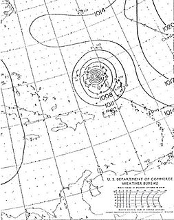
WTropical Storm Erika was a short-lived tropical cyclone that brought minor impacts to the Lesser Antilles. The fifth named storm of the 2009 Atlantic hurricane season, Erika originated out of a tropical wave on September 1 near the Lesser Antilles. Although it was a disorganized system, it was immediately declared a tropical storm, rather than a tropical depression. Later that day, the system reached its peak intensity with winds of 50 mph (85 km/h) and a barometric pressure of 1004 mbar. Increased wind shear caused the storm to weaken shortly thereafter, with Erika barely maintaining tropical storm-status by September 2. Later that day, the storm passed over the island of Guadeloupe and entered the Caribbean Sea. On September 3, Erika weakened to a tropical depression as the low pressure center became fully displaced from convective activity. Later that day, the system degenerated into a remnant low before dissipating near Puerto Rico on September 4.
 W
WTropical Storm Erika was one of the deadliest and most destructive natural disasters in Dominica since Hurricane David in 1979. The fifth named storm of the 2015 Atlantic hurricane season, Erika developed from a westward-moving tropical wave while well east of the Lesser Antilles. Hostile conditions, including dry air and wind shear, inhibited significant development, and Erika failed to acquire sustained winds beyond 50 mph (80 km/h). Contrary to predictions of a northwesterly recurvature, the cyclone persisted on a westerly course and passed through the Leeward Islands and emerged over the Caribbean Sea on August 27. Erika succumbed to adverse conditions the following day, dissipating as a tropical cyclone near the Dominican Republic. The remnant system persisted for several more days, ultimately moving across the Gulf of Mexico, before dissipating over Georgia on September 3.
 W
WHurricane Frederic was an intense and damaging tropical cyclone that carved a path of damage from the Lesser Antilles to Quebec, in particular devastating areas of the United States Gulf Coast. Though only five were killed directly, the US$1.77 billion in damage accrued by Frederic made it the Atlantic basin's costliest tropical cyclone on record at the time. Prior to its final landfall, the threat that Frederic imposed on areas of the U.S. Gulf Coast triggered a mass exodus from the region larger than any other evacuation in the past. While the storm primarily impacted the U.S. states of Mississippi and Alabama, lesser effects were felt throughout the Greater and Lesser Antilles, as well as inland North America.
 W
WHurricane Georges was a powerful and long-lived Cape Verde Category 4 hurricane which caused severe destruction as it traversed the Caribbean and Gulf of Mexico in September 1998, making seven landfalls along its path. Georges was the seventh tropical storm, fourth hurricane, and second major hurricane of the 1998 Atlantic hurricane season. It became the most destructive storm of the season, the costliest Atlantic hurricane since Hurricane Andrew in 1992 and remained the costliest until Hurricane Charley in 2004, and the deadliest since Hurricane Gordon in 1994. Georges killed 604 people, mainly on the island of Hispaniola, and caused extensive damage resulting at just under $10 billion in damages mostly in St. Kitts and Nevis, Puerto Rico and Hispaniola.
 W
WHurricane Gonzalo was the second tropical cyclone, after Hurricane Fay, to directly strike the island of Bermuda in a one-week time frame in October 2014, and was the first Category 4 Atlantic hurricane since Hurricane Ophelia in 2011. At the time, it was the strongest hurricane in the Atlantic since Igor in 2010. Gonzalo struck Bermuda less than a week after the surprisingly fierce Hurricane Fay; 2014 was the first season in recorded history to feature two hurricane landfalls in Bermuda. A powerful Atlantic tropical cyclone that wrought destruction in the Leeward Islands and Bermuda, Gonzalo was the seventh named storm, sixth and final hurricane and only the second major hurricane of the below-average 2014 Atlantic hurricane season. The storm formed from a tropical wave on October 12, while located east of the Lesser Antilles. It made landfall on Antigua, Saint Martin, and Anguilla as a Category 1 hurricane, causing damage on those and nearby islands. Antigua and Barbuda sustained US$40 million in losses, and boats were abundantly damaged or destroyed throughout the northern Leeward Islands. The storm killed three people on Saint Martin and Saint Barthélemy. Gonzalo tracked northwestward as it intensified into a major hurricane. Eyewall replacement cycles led to fluctuations in the hurricane's structure and intensity, but on October 16, Gonzalo peaked with maximum sustained winds of 145 mph.
 W
WHurricane Hortense was the first tropical cyclone to make landfall in Guadeloupe and Puerto Rico since Hurricane Hugo in 1989, and the second most intense hurricane during the 1996 Atlantic hurricane season. The eighth tropical cyclone, eighth named storm, and sixth hurricane of the season. Hortense developed on September 3 from a tropical wave in the central Atlantic Ocean.
 W
WHurricane Hugo was a powerful Cape Verde tropical cyclone that inflicted widespread damage across the northeastern Caribbean and the Southeastern United States in September 1989. Across its track, Hugo affected approximately 2 million people. Its direct effects killed 67 people and inflicted $11 billion in damage. The damage wrought by the storm was more costly than any Atlantic hurricane preceding it. At its peak strength east of the Lesser Antilles, Hugo was classified as a Category 5 hurricane—the highest rating on the Saffir–Simpson scale. Over the course of five days, Hugo made landfalls on Guadeloupe, Saint Croix, Puerto Rico, and South Carolina, bringing major hurricane conditions to these and surrounding areas. Lesser effects were felt along the periphery of the hurricane's path in the Lesser Antilles and across the Eastern United States into Eastern Canada. The scale of Hugo's impacts led to the retirement of the name Hugo from Atlantic hurricane names.
 W
WHurricane Inez was a powerful major hurricane that affected the Caribbean, Bahamas, Florida, and Mexico in 1966. It was the first storm on record to affect all of those areas. It originated from a tropical wave over Africa, and became a tropical depression by September 21. It moved slowly westward, initially failing to intensify much; it was upgraded to Tropical Storm Inez on September 24. The storm strengthened into a hurricane and was quickly intensifying when it struck the French overseas region of Guadeloupe on September 27. Inez severely damaged the island's banana and sugar crops, and thousands of homes were damaged, leaving 10,000 people homeless. Damage on Guadeloupe was estimated at $50 million, and there were 40 deaths. After entering the Caribbean, Inez briefly weakened before restrengthening, attaining peak sustained winds of 150 mph (240 km/h) on September 28. That day a hurricane hunters flight reported a gust of 197 mph (317 km/h), which was the highest recorded at the time.
 W
WHurricane Irene was a large and destructive tropical cyclone which affected much of the Caribbean and East Coast of the United States during late August 2011. The ninth named storm, first hurricane, and first major hurricane of the 2011 Atlantic hurricane season, Irene originated from a well-defined Atlantic tropical wave that began showing signs of organization east of the Lesser Antilles. Due to development of atmospheric convection and a closed center of circulation, the system was designated as Tropical Storm Irene on August 20, 2011. After intensifying, Irene made landfall in St. Croix as a strong tropical storm later that day. Early on August 21, the storm made a second landfall in Puerto Rico. While crossing the island, Irene strengthened into a Category 1 hurricane. The storm paralleled offshore of Hispaniola, continuing to slowly intensify in the process. Shortly before making four landfalls in the Bahamas, Irene peaked as a 120 mph (190 km/h) Category 3 hurricane.
 W
WHurricane Iris was the first of three tropical cyclones to affect the Lesser Antilles in a three-week period, preceding the more destructive hurricanes Luis and Marilyn. The ninth named storm and fifth hurricane of the 1995 Atlantic hurricane season, Iris developed from a tropical wave to the east of the Lesser Antilles on August 22 and attained hurricane status within 30 hours. The hurricane weakened to a tropical storm before crossing the islands of the eastern Caribbean from August 26 through August 28. During that time, Iris became one of four active tropical storms in the Atlantic basin. Earlier it had interacted with Hurricane Humberto, and beginning on August 30, Iris interacted with Tropical Storm Karen. Iris re-intensified into a hurricane and attained peak sustained winds of 110 mph (175 km/h) while moving slowly across the central Atlantic. The hurricane accelerated to the north and absorbed a dissipating Karen on September 3. Iris weakened to a tropical storm and became extratropical on September 4, though its remnants reattained hurricane-force winds before affecting western Europe on September 7.
 W
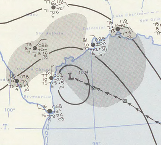
WHurricane Isaac was a deadly and destructive tropical cyclone that came ashore in the U.S. state of Louisiana during August 2012. The ninth named storm and fourth hurricane of the annual hurricane season, Isaac originated from a tropical wave that moved off the west coast of Africa on August 16. Tracking generally west, a broad area of low pressure developed along the wave axis the next day, and the disturbance developed into a tropical depression early on August 21 while several hundred miles east of the Lesser Antilles. The system intensified into a tropical storm shortly thereafter, but high wind shear initially prevented much change in strength.
 W
WHurricane Jose was the fourteenth tropical cyclone, tenth named storm, and seventh hurricane of the annual season that caused moderate damage in the Lesser Antilles in October 1999. Jose developed from a tropical wave several hundred miles east of the Windward Islands on October 17. The depression intensified and was subsequently upgraded to Tropical Storm Jose on October 18. The storm tracked northwestward and was upgraded to a hurricane the following day as it approached the northern Leeward Islands. Jose briefly peaked as a Category 2 hurricane with winds of 100 mph (160 km/h) on October 20. However, wind shear weakened the storm back to a Category 1 hurricane before it struck Antigua. Further deterioration occurred and Jose weakened to a tropical storm before landfall in Tortola on October 21. While located north of Puerto Rico on October 22, the storm turned northward, shortly before curving north-northeastward. Wind shear decreased, allowing Jose to re-intensify into a hurricane while passing east of Bermuda on October 24. However, on the following day, wind shear increased again, while sea surface temperatures decreased, causing Jose to weaken and quickly transition into an extratropical cyclone.
 W
WHurricane Klaus was a minimal Atlantic hurricane that dropped heavy rainfall across the Lesser Antilles in October 1990. The eleventh tropical cyclone and sixth hurricane of the 1990 Atlantic hurricane season, Klaus developed from a tropical wave on October 3 a short distance east of Dominica. It drifted northwestward, and quickly intensified to attain hurricane status on October 5. Though its closest approach to the Lesser Antilles was within 12 miles (19 km), the strongest winds remained to its northeast due to strong wind shear, which caused Klaus to steadily weaken. After deteriorating into a tropical depression, Klaus briefly restrengthened over the Bahamas before dissipating on October 9 under the influence of developing tropical storm, Marco.
 W
WHurricane Luis was a very large, long-lived, powerful and very destructive Category 4 Cape Verde hurricane, as well as one of the strongest and most notable hurricanes of the 1995 Atlantic hurricane season. Luis was also the strongest hurricane to make landfall, and the third-most intense hurricane recorded during the extremely active season. It was the twelfth tropical storm, sixth hurricane, and second major hurricane of the season. At one point, the storm was one of four simultaneous tropical systems in the Atlantic basin, along with Humberto, Iris, and Karen. The storm lasted for 14 days as a tropical storm between late August and mid-September.
 W
WHurricane Maria was a deadly Category 5 hurricane that devastated Dominica, St Croix, and Puerto Rico in September 2017. It is regarded as the worst natural disaster in recorded history to affect those islands and was also the deadliest Atlantic hurricane since Mitch in 1998. The tenth most intense Atlantic hurricane on record and the most intense tropical cyclone worldwide in 2017, Maria was the thirteenth named storm, eighth consecutive hurricane, fourth major hurricane, second Category 5 hurricane, and deadliest storm of the hyperactive 2017 Atlantic hurricane season. At its peak, the hurricane caused catastrophic destruction and numerous fatalities across the northeastern Caribbean, compounding recovery efforts in the areas of the Leeward Islands already struck by Hurricane Irma. Total losses from the hurricane are estimated at upwards of $91.61 billion, mostly in Puerto Rico, ranking it as the third-costliest tropical cyclone on record.
 W
WHurricane Marilyn was the most powerful hurricane to strike the Virgin Islands since Hurricane Hugo of 1989, and the third such tropical cyclone in roughly a two-week time span to strike or impact the Leeward Islands, the others being Hurricane Iris and the much more powerful and destructive Hurricane Luis. The thirteenth named storm, seventh hurricane and third major hurricane of the extremely active 1995 Atlantic hurricane season, Marilyn formed on September 12 as a tropical depression from a tropical wave that moved off the coast of Africa on September 7. After formation, the storm quickly became a tropical storm, and steadily intensified into a hurricane by the time it struck the Lesser Antilles on September 14 at Category 1 strength. Entering the northeastern Caribbean Sea, rapid intensification ensued and it peaked on September 16 north of Puerto Rico as a Category 3 hurricane shortly after it had impacted the U.S. Virgin Islands. A Hurricane Hunter reconnaissance flight reported hail, which is unusual for tropical cyclones. After heading north past Bermuda, Marilyn weakened and became extratropical on September 22. The remnant circulation wandered the Atlantic Ocean from September 23 – October 1, just south of Nova Scotia.
 W
WHurricane Rafael produced minor damage in the northeastern Caribbean Sea in mid-October 2012. The seventeenth named storm and ninth hurricane of the annual hurricane season, Rafael originated from a tropical wave roughly 230 mi (370 km) south-southeast of Saint Croix on October 12; because the system already contained tropical storm-force winds, it skipped tropical depression status. Though initially disorganized due to moderate wind shear, a subsequent decrease allowed for shower and thunderstorm activity to develop in earnest by October 14. While moving north-northwestward the following morning, Rafael intensified into a Category 1 hurricane. A cold front off the East Coast of the United States caused the system to turn northward and eventually northeastward by October 16, at which time Rafael attained its peak intensity with maximum sustained winds of 90 mph (150 km/h). As the cyclone entered a more stable atmosphere and tracked across increasingly cooler sea surface temperatures, it began extratropical transition, a process the system completed by the following afternoon.