 W
WExtratropical cyclones, sometimes called mid-latitude cyclones or wave cyclones, are low-pressure areas which, along with the anticyclones of high-pressure areas, drive the weather over much of the Earth. Extratropical cyclones are capable of producing anything from cloudiness and mild showers to heavy gales, thunderstorms, blizzards, and tornadoes. These types of cyclones are defined as large scale (synoptic) low pressure weather systems that occur in the middle latitudes of the Earth. In contrast with tropical cyclones, extratropical cyclones produce rapid changes in temperature and dew point along broad lines, called weather fronts, about the center of the cyclone.
 W
WThe 1996 Lake Huron Cyclone, commonly referred to as Hurricane Huron, Cyclone Huron, or the Lake Huron Subtropical Cyclone of 1996, was an extremely rare, strong cyclonic storm system that developed over Lake Huron in September 1996. The system resembled a subtropical cyclone at its peak, having some characteristics of a tropical cyclone. It was the first time such a storm has ever been recorded over the Great Lakes region.
 W
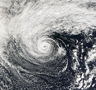
WThe 2006 Central Pacific cyclone, also known as Invest 91C or Storm 91C, was an unusual weather system that formed in 2006. Forming on October 30 from a mid-latitude cyclone in the north Pacific mid-latitudes, it moved over waters warmer than normal. The system acquired some features more typical of subtropical and even tropical cyclones. However, as it neared western North America, the system fell apart, dissipating soon after landfall, on November 4. Moisture from the storm's remnants caused substantial rainfall in British Columbia and the Pacific Northwest. The exact status and nature of this weather event is unknown, with meteorologists and weather agencies having differing opinions.
 W
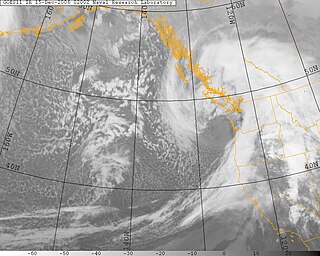
WThe October 2010 North American storm complex is the name given to a historic extratropical cyclone that impacted North America. The massive storm complex caused a wide range of weather events including a major serial derecho stretching from the Gulf Coast to the Great Lakes, a widespread tornado outbreak across the Southeast United States and Midwest and a blizzard across portions of the Canadian Prairies and the Dakotas. The cyclone's lowest minimum pressure of 955.2 mb (28.21 inHg) made it the second most intense non-tropical system recorded in the continental United States (CONUS). The lowest confirmed pressure for a non-tropical system in the continental United States was set by a January 1913 Atlantic coast storm.
 W
WThe November 2011 Bering Sea cyclone was one of the most powerful extratropical cyclones to affect Alaska on record. On November 8, the National Weather Service (NWS) began issuing severe weather warnings, saying that this was a near-record storm in the Bering Sea. It rapidly deepened from 973 mb (28.7 inHg) to 948 mb (28.0 inHg) in just 24 hours before bottoming out at 943 mbar, roughly comparable to a Category 3 or 4 hurricane. The storm had been deemed life-threatening by many people. The storm had a forward speed of at least 60 mph (97 km/h) before it had reached Alaska. The storm began affecting Alaska in the late hours of November 8, 2011. The highest gust recorded was 93 mph (150 km/h) on Little Diomede Island. One person was reported missing after being swept into the Bering Sea, and he was later pronounced dead.
 W
WThe 2013 New Zealand winter storm was an highly intense extratropical cyclone which affected New Zealand on 20–22 June. The storm brought strong winds and high waves especially around the Wellington Region, and further afield chilling cold temperatures and heavy snow to the South Island. The storm was described by the New Zealand National Institute of Water and Atmospheric Research (NIWA) as an extreme event. The maximum 10-minute average, sustained wind reading, recorded at Wellington airport was 101 km/hour, with individual gusts up to 130–140 km/hour at this location. Winds were equivalent to the strength of a category 1 or 2 hurricane on the Saffir–Simpson hurricane wind scale. Record wave heights of 15 m peak to trough were recorded by a buoy offshore from Baring Head in the Cook Strait. The highest wind gust was 202 km/hr, at Mt Kaukau, Wellington.
 W
WThe January 2013 Northwest Pacific cyclone was a powerful extratropical cyclone which caused heavy rainfall and a severe blizzard in Japan in January 2013. Forming northeast of Taiwan on January 13 and absorbing Tropical Depression Bising soon afterward, the storm quickly intensified in the southern sea off Japan on January 14, and reached its peak intensity east of Japan on January 15, with its central atmospheric pressure decreasing to 936 hPa (27.6 inHg). The system then weakened, crossed the Kamchatka Peninsula late on January 18, and dissipated east of Hokkaido on January 21.
 W
WThe 2013 Sardinia floods took place in and around the Sardinian town of Olbia between 17 and 19 November 2013. They also affected other parts of northeastern Sardinia and killed at least 18 people. Thousands of people were left homeless. The places which suffered the most damage were Olbia, and in general the whole region of Gallura. The flood caused damages of over 1 billion euro.
 W
WAn Alberta clipper, also known as a Canadian clipper, is a fast moving low pressure area weather system which generally affects the central provinces of Canada and parts of the Upper Midwest, Great Lakes, and New England, precipitating a sudden temperature drop and sharp winds. Alberta clippers take their name from Alberta, the province from which they appear to descend, and from clipper ships of the 19th century, one of the fastest ships of that time.
 W
WAustralian east coast lows are extratropical cyclones. The most intense of these systems have many of the characteristics of subtropical cyclones. They develop between 25˚ south and 40˚ south and within 5˚ of the Australian coastline, typically during the winter months, but may occur in autumn and spring as well. Each year there are about ten "significant impact" maritime lows.
 W
WCyclone Friedhelm, also referred to unofficially as Hurricane Bawbag, was an intense extratropical cyclone which brought hurricane-force winds to Scotland at the beginning of December 2011. The storm also brought prolonged gales and rough seas to the rest of the British Isles, as well as parts of Scandinavia. On 8 December, winds reached up to 165 mph (266 km/h) at elevated areas, with sustained wind speeds of up to 80 mph (130 km/h) reported across populous areas. The winds uprooted trees and resulted in the closure of many roads, bridges, schools and businesses. Overall, the storm was the worst to affect Scotland in 10 years, though a stronger storm occurred less than a month afterwards, on 3 January 2012. Although the follow-up storm was more intense, the winter of 2011–12 is usually remembered for Bawbag among Scots.
 W
WThe November 2014 Bering Sea cyclone was the most intense extratropical cyclone ever recorded in the Bering Sea, which formed from a new storm developing out of the low-level circulation that separated from Typhoon Nuri, which soon absorbed the latter. The cyclone brought gale-force winds to the western Aleutian Islands and produced even higher gusts in other locations, including a 97 miles per hour (156 km/h) gust in Shemya, Alaska. The storm coincidentally occurred three years after another historic extratropical cyclone impacted an area slightly further to the east.
 W
WA Black nor'easter is a persistent and potentially violent north-easterly storm that occurs on the east coast of Australia during spring and summer, usually about two days a year. It is not a convection wind, but a storm system that develops offshore which can last several days. This is heralded by the rapid build-up of dense black cloud that can convert to a gale in well under one hour, and also bringing with it a heavy rainfall event usually accompanied by a thunderstorm. This type of storm was first recorded during the 1800s.
 W
WA Colorado low is a low-pressure area that forms in southeastern Colorado or northeastern New Mexico, typically in the winter. After forming, the system moves across the Great Plains. Colorado lows can produce heavy wintry precipitation, and have a general east to northeast movement, impacting regions as far north as Winnipeg and as far east as the Atlantic coast. If upper level conditions are right, the jet stream can push the low farther south, bringing wintry precipitation as far as Texas. When pushed this far south, the system is often referred to as a "blue norther". On the more typical track, a Colorado low can be similar to an Alberta clipper. In the winter Colorado lows are responsible for a majority of the snow that the Midwest receives; however, summer systems can trigger long-lasting convective systems, including severe weather. Spring and early summer Colorado low cyclogenesis can result in significant tornado outbreaks over the Great Plains and Midwest.
 W
WCyclone Anne was a European windstorm which caused €75 million in damage across western Europe in early January 2014, followed days later by Cyclone Christina.
 W
WCyclone Christina was a European windstorm which caused three fatalities and €375 million in damage across western Europe in early January 2014, making landfall several days after Cyclone Anne. Forming out of a powerful nor'easter off the coast of North America, Christina reached a peak intensity of 934 mb (27.6 inHg) as it crossed western Europe.
 W
WCyclone Numa, also known as Medicane Numa, was a Mediterranean tropical-like cyclone with the properties of a subtropical cyclone. Numa formed on 11 November 2017 west of the British Isles, out of the extratropical remnants of Tropical Storm Rina, the seventeenth named storm of the 2017 Atlantic hurricane season. Subsequently, on 17 November, Numa acquired subtropical characteristics before reaching peak intensity on 18 November, becoming a rare "medicane". After making landfall in Greece on 18 November, Numa rapidly weakened, and was later absorbed into another extratropical storm on 20 November. The flooding triggered by Numa became the worst weather event Greece had experienced since 1977, and the storm caused an estimated $100 million in damages in Europe.
 W
WCyclone Qendresa, also known as Medicane Qendresa, was one of the most intense Mediterranean tropical-like cyclones on record, which struck Malta and the Italian island of Sicily in 2014. The storm formed on 5 November and rapidly intensified two days later, reaching peak intensity on 7 November, due to a cold-core low aloft. Qendresa directly hit Malta in the afternoon and then crossed the eastern coast of Sicily on 8 November. Later, the cyclone weakened significantly and dissipated over Crete on 11 November. Academic sources indicate that Qendresa transitioned into a subtropical cyclone, prior to reaching peak intensity. Qendresa caused three fatalities, and at least $250 million in damages in Italy.
 W
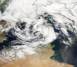
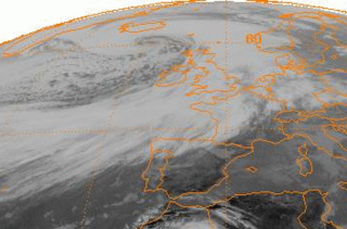
WEuropean windstorms are powerful extratropical cyclones which form as cyclonic windstorms associated with areas of low atmospheric pressure. They can occur throughout the year, but are most frequent between October and March, with peak intensity in the winter months. Deep areas of low pressure are common over the North Atlantic, and occasionally start as nor'easters off the New England coast. They frequently track across the North Atlantic Ocean towards the north of Scotland and into the Norwegian Sea, which generally minimizes the impact to inland areas; however, if the track is further south, it may cause adverse weather conditions across Central Europe, Northern Europe and especially Western Europe. The countries most commonly affected include the United Kingdom, Ireland, the Netherlands, Norway, the Faroe Islands and Iceland.
 W
WThe following is a list of notable European windstorms.
 W
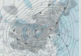
WExplosive cyclogenesis is the rapid deepening of an extratropical cyclonic low-pressure area. The change in pressure needed to classify something as explosive cyclogenesis is latitude dependent. For example, at 60° latitude, explosive cyclogenesis occurs if the central pressure decreases by 24 mbar (hPa) or more in 24 hours. This is a predominantly maritime, winter event, but also occurs in continental settings, even in the summer. This process is the extratropical equivalent of the tropical rapid deepening. Although their cyclogenesis is totally different from that of tropical cyclones, bomb cyclones can produce winds of 74 to 95 mph the same order as the first categories of the Saffir-Simpson scale and give heavy precipitation. Even though only a minority of the bombs become so strong, some weaker ones have also caused significant damage.
 W
WThe February 2017 North American blizzard was a fast-moving but powerful blizzard that affected the Northeastern United States with severe weather in the time span of February 8–9. Forming as an Alberta clipper in the northern United States, the system initially produced light snowfall from the Midwest to the Ohio Valley as it tracked southeastwards. It eventually reached the East Coast of the United States and began to rapidly grow into a powerful nor'easter. Up to 18 inches (46 cm) of snow as well as blizzard conditions were recorded in some of the hardest hit areas before the system moved away from the coastline early on February 10.
 W
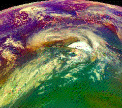
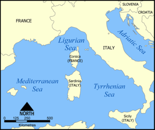
WA Genoa low is a cyclone that forms or intensifies from a pre-existing cyclone to the south of the Alps over the Gulf of Genoa, Ligurian Sea, Po Valley and northern Adriatic. Vb cyclones are rare events which occur on average only 2.3 times per year.
 W
WThe Great Arctic Cyclone, or "Great Arctic Cyclone of 2012," was a powerful extratropical cyclone that was centered on the Arctic Ocean in early August 2012. Such storms are rare in the Arctic summer, although common in the winter. The Great Arctic Cyclone was the strongest summer storm in the Arctic and the 13th strongest storm observed at any time in the Arctic, since satellite observations began in 1979.
 W
WThe Great Blizzard of 1978 was a historic winter storm that struck the Ohio Valley and Great Lakes regions from Wednesday, January 25 through Friday, January 27, 1978. It is often cited as one of the most severe blizzards in US history. The third lowest non-tropical atmospheric pressure ever recorded in the mainland United States occurred as the storm passed over Mount Clemens, Michigan, where the barometer fell to 956.0 mb (28.23 inHg) on January 26.
 W
WA Gulf low or Texas Low is a low pressure area that forms or intensifies over the Gulf of Mexico and move northeast on the western side of the Appalachian mountains and sometimes on the Atlantic coast to become a nor'easter. Because they move from over or near the Gulf of Mexico, these storm systems are capable of transporting copious amounts of moisture with them. At their strongest, these storm systems are even more potent snowfall producers than panhandle hooks, primarily because of the mixing of Atlantic Ocean moisture into the storm system once they cross the Appalachian Mountains. Because of the general west to east movement of weather systems in the mid latitudes of the northern hemisphere, Gulf Lows rarely affect areas west of the Mississippi River. One such exception was the Halloween Blizzard of 1991.
 W
WHurricane Ana was the second tropical cyclone in 2014 to threaten the U.S. state of Hawaii with a direct hit, after Iselle in August. The twenty-first named storm and fifteenth hurricane of the 2014 Pacific hurricane season, Ana formed from a disturbance that formed in the Central Pacific in mid-October. It rapidly consolidated, and a tropical depression developed by October 13. Aided by favorable conditions, Ana gradually strengthened while moving westward, threatening to pass over the island chain of Hawaii once or several times as indicated by early forecasts. By October 17, it had strengthened to a hurricane south of Hawaii and reached its peak intensity shortly afterwards while also making its closest approach. Afterwards, Ana weakened and began to fluctuate in intensity as it turned to the north and eventually northeast as it rounded a subtropical ridge and interacted with a cold front before becoming a hurricane briefly again on October 25. Ana transitioned into an extratropical cyclone on October 26, and raced across the northwest Pacific before dissipating by October 28 after it came ashore in Western Canada.
 W
WThe July 2016 North China cyclone was a devastating extratropical cyclone which produced torrential precipitation and caused widespread flash floods over North China and portions of nearby regions, resulting in at least 184 deaths and ¥33.19 billion of damage in China.
 W
WKona storms are a type of seasonal cyclone in the Hawaiian Islands, usually formed in the winter from winds coming from the westerly "kona" direction. They are mainly cold core cyclones, which places them in the extratropical cyclone rather than the subtropical cyclone category. Hawaii typically experiences two to three annually, which can affect the state for a week or more. Among their hazards are heavy rain, hailstorms, flash floods and their associated landslides, high elevation snow, high winds which result in large surf and swells, and waterspouts.
 W
WA nor'easter is a synoptic-scale extratropical cyclone in the western North Atlantic Ocean. The name derives from the direction of the winds that blow from the northeast. The original use of the term in North America is associated with storms that impact the upper north Atlantic coast of the United States and the Atlantic Provinces of Canada. In 2019, Tropical Storm Melissa became the first tropical or subtropical Nor'easter in history.
 W
WThe January 2010 North American winter storms were a group of seven powerful winter storms that affected Canada and the Contiguous United States, particularly California. The storms developed from the combination of a strong El Niño episode, a powerful jet stream, and an atmospheric river that opened from the West Pacific Ocean into the Western Seaboard. The storms shattered multiple records across the Western United States, with the sixth storm breaking records for the lowest recorded air pressure in multiple parts of California, which was also the most powerful winter storm to strike the Southwestern United States in 140 years. The fourth, fifth, and sixth storms spawned several tornadoes across California and Arizona, with at least 6 tornadoes reported in California and another tornado reported in Arizona; the storms also spawned multiple waterspouts off the coast of California. The storms dumped record amounts of rain and snow in the Western United States, and also brought hurricane-force winds to the U.S. West Coast, causing flooding and wind damage, as well as triggering blackouts across California that cut the power to more than 1.3 million customers. The storms killed at least 10 people, and caused more than $3 million in damages.
 W
WPacific Northwest windstorms, sometimes colloquially known as Big Blows, are extratropical cyclones which form in the Pacific basin, and affect land areas in the Pacific Northwest of the United States and British Columbia, Canada. They form as cyclonic windstorms associated with areas of low atmospheric pressure that track across the North Pacific Ocean towards western North America. Deep low pressure areas are relatively common over the North Pacific. They are most common in the winter months. On average, the month when most windstorms form is November or December.
 W
WA panhandle hook is a relatively infrequent winter storm system whose cyclogenesis occurs in the South to southwestern United States from the late fall through winter and into the early spring months. They trek to the northeast on a path towards the Great Lakes region, as the southwesterly jet streams are most prevalent, usually affecting the Midwestern United States and Eastern Canada. Panhandle hooks account for some of the most memorable and deadly blizzards and snowstorms in North America. The name is derived from the region of surface cyclogenesis in the Texas panhandle and Oklahoma panhandle regions. In some winters, there are no panhandle hook storms; in others, there are several.
 W
WA rainband is a cloud and precipitation structure associated with an area of rainfall which is significantly elongated. Rainbands can be stratiform or convective, and are generated by differences in temperature. When noted on weather radar imagery, this precipitation elongation is referred to as banded structure. Rainbands within tropical cyclones are curved in orientation. Tropical cyclone rainbands contain showers and thunderstorms that, together with the eyewall and the eye, constitute a hurricane or tropical storm. The extent of rainbands around a tropical cyclone can help determine the cyclone's intensity.