 W
WTyphoon Alex, known in the Philippines as Typhoon Etang, affected the Taiwan, China, and South Korea during July 1987. Typhoon Alex developed from the monsoon trough that spawned a tropical disturbance late on July 21 southwest of Guam which organized into a tropical depression shortly thereafter. The system steadily became better organized, and the next day, a tropical depression had developed. Satellite intensity estimates gradually increased, and on July 23, the depression intensified into Tropical Storm Alex. After initially tracking west-northwest, Tropical Storm Alex started tracking northwest. An eye developed on July 24, and on the next day, Alex was classified as a typhoon, when Alex attained its peak intensity of 120 km/h (75 mph) and a minimum barometric pressure of 970 mbar (29 inHg). Alex weakened while tracking more northward, though interaction with Taiwan resulted in a more westward track starting on July 27. The storm struck near Shanghai as a tropical storm, and weakened over land, although it remained identifiable through August 2.
 W
WTyphoon Agnes, known in the Philippines as Typhoon Pining, produced among the heaviest rains recorded during the 20th century in South Korea, with 710 mm (28 in) falling over a two-day span. The storm originated as a tropical depression near Guam on August 25, 1981. Moving along a west-northwest to northwest track, the system gradually strengthened as deep convection organized around it. The depression was assigned the name Agnes on August 27 following the development of gale-force winds. Further intensification to typhoon-status occurred by August 29. Agnes attained its peak intensity on August 31 over the East China Sea as a Category 2-equivalent on the Saffir–Simpson hurricane wind scale with winds of 175 km/h (110 mph). Subsequent interaction with a mid-latitude trough induced an extratropical transition as the cyclone slowed and turned north. The system had lost most of its tropical characteristics by September 1, with the majority of convection sheared northeast over South Korea and Japan. Agnes later accelerated northeast and completed its transition on September 3. The remnants continued along this course, impacting northern Japan and the Kamchatka Peninsula before last being noted on September 6 near the International Dateline.
 W
WTyphoon Billie was the first typhoon officially monitored by the Joint Typhoon Warning Center. The storm brought floods to several East Asian countries in July 1959. Billie developed from a tropical disturbance west of Kiribati on July 12. Situated within favorable conditions, the system quickly reached tropical storm intensity before strengthening further to typhoon status a day after formation. Intensification continued until Billie reached its peak intensity on July 14 east of Taiwan with maximum sustained winds of 165 km/h (105 mph) and a minimum barometric pressure of 970 mbar. Slight weakening occurred before the typhoon made landfall on Zhejiang in China on July 16. After tracking inland, Billie curved northward and moved over the Yellow Sea before making a final landfall on North Korea on July 17; the storm transitioned into an extratropical cyclone shortly afterwards before dissipating over the Sea of Japan a day later.
 W
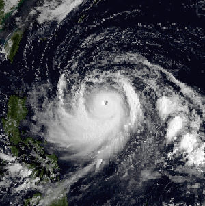
WTyphoon Bolaven, known in the Philippines as Typhoon Julian, was regarded as the most powerful storm to strike the Korean Peninsula in nearly a decade, with wind gusts measured up to 186 km/h (116 mph). Forming as a tropical depression on August 19, 2012 to the southwest of the Mariana Islands, Bolaven steadily intensified as it slowly moved west-northwestward in a region favoring tropical development. The system was soon upgraded to a tropical storm less than a day after formation and further to a typhoon by August 21. Strengthening became more gradual thereafter as Bolaven grew in size. On August 24, the system attained its peak intensity with winds of 185 km/h (115 mph) and a barometric pressure of 910 mbar. Weakening only slightly, the storm passed directly over Okinawa on August 26 as it began accelerating toward the north. Steady weakening continued as Bolaven approached the Korean Peninsula and it eventually made landfall in North Korea late on August 28 before transitioning into an extratropical cyclone. The remnants rapidly tracked northeastward over the Russian Far East before turning eastward and were last noted on September 1 crossing the International Dateline.
 W
WTyphoon Chaba, known in the Philippines as Typhoon Igme, was the fourth most intense tropical cyclone in 2016 and the strongest tropical cyclone to make landfall in South Korea since Sanba in 2012. Chaba also caused 7 deaths in the country. Typhoon Chaba was the eighteenth named storm and the eighth typhoon of the 2016 Pacific typhoon season.
 W
WTyphoon Chan-hom, known in the Philippines as Typhoon Falcon, was a large, powerful and long-lived tropical cyclone that affected most countries in the western Pacific basin. The ninth named storm of the 2015 Pacific typhoon season, Chan-hom developed on June 29 from a westerly wind burst that also spawned Tropical Cyclone Raquel in the southern hemisphere. Chan-hom slowly developed while moving to the northwest, aided by warm waters but disrupted by wind shear. The storm meandered near the Northern Marianas Islands, passing over the island of Rota before beginning a steady northwest track. While near the island, the storm dropped heavy rainfall on neighboring Guam, causing flooding and minor power outages. Chan-hom intensified into a typhoon on July 7, and two days later passed between the Japanese islands of Okinawa and Miyako-jima. There, strong winds left 42,000 people without power, while 27 people were injured. Around that time, the storm caused a surge in the monsoon trough, in conjunction with Tropical Storm Linfa, which caused flooding and killed 16 people in the Philippines.
 W
WTyphoon Dinah, known as Typhoon Luding in the Philippines, was the fourth typhoon to form during August 1987. An area of low pressure developed near Guam on August 19, and two days later, the low reached tropical storm intensity as it moved generally west. Intensification was initially gradual, with Dinah becoming a typhoon early on August 24, before it subsequently intensified at a faster pace. Dinah reached its highest strength on August 26 before turning northward on August 28 and into a less favorable conditions aloft, which prompted weakening. Dinah entered the Sea of Japan after passing near Okinawa on August 29, where Dinah leveled off in intensity. The system then began to recurve towards southwestern Japan, and after tracking through the area, Dinah transitioned into an extratropical cyclone on August 31, although the remnants could be traced for four more days as it approached the International Date Line.
 W
WSuper Typhoon Emma was a powerful typhoon that brought 140 mph (230 km/h) winds and 22 inches (560 mm) of rain to Okinawa and South Korea. Emma left 77 people dead and over $8 million in damage. Emma was one of several typhoons to cause significant damage to Okinawa during the mid-1950s.
 W
WTyphoon Ewiniar, known in the Philippines as Typhoon Ester, was the third named storm of the 2006 Pacific typhoon season and one that lasted for twelve days as a tropical cyclone, moving on a generally northward track. During its lifespan, it affected Palau, Yap, eastern China, the Ryūkyū Islands of Japan, South Korea as well as North Korea, briefly threatening to make landfall in North Korea before doing so in South Korea. Ewiniar is responsible for at least 181 deaths. However, an unofficial report stated that up to 10,000 people had been killed by flooding in North Korea, with 4,000 people missing.
 W
WTyphoon Francisco was a small tropical cyclone that impacted Japan and the Korean Peninsula in August 2019. Originating from a trough over the open Pacific Ocean on July 29, Francisco developed into a tropical depression on August 1. Tracking along a northwest course toward Japan, the system steadily intensified over the following days. It attained typhoon strength on August 5 and soon struck Kyushu at peak strength with winds of 130 km/h (80 mph). Thereafter, the weakened storm traversed the Korea Strait before striking South Korea on August 6. Turning toward the east, Francisco transitioned into an extratropical cyclone on August 7. It later impacted Hokkaido before continuing across the northern Pacific and dissipating.
 W
WTropical Storm Gladys in August 1991 was a large tropical cyclone that affected Japan and South Korea. An area of disturbed weather first formed within the Western Pacific monsoon trough on August 15. Slowly organizing, the disturbance developed into a tropical depression on August 15. Heading northwest, Gladys became a tropical storm the following day. Despite forecasts of significant strengthening, its large size only enabled slow intensification. After turning west, Gladys attained peak intensity on August 21 near Okinawa. After turning north and bypassing Kyushu, Gladys began to encounter significant wind shear, which caused weakening. Gladys veered west, interacting with land. Gladys weakened to a tropical depression on August 24, and dissipated the next day.
 W
WTyphoon Holly, known in the Philippines as Typhoon Isang, affected South Korea, Japan, and the Soviet Union during August 1984. Holly originated from the monsoon trough that extended eastward from its original position in mid-August 1984. Over a period of several days, the system slowly became better organized as it tracked westward, although the system did not initially develop a well-defined center. On August 15, a tropical depression was declared, and on the next day, the depression was upgraded into Tropical Storm Holly. Holly slowly gained strength, becoming a typhoon on August 17 as it passed near Okinawa. The typhoon turned northwest and then north as it rounded a subtropical ridge. At noon on August 19, Holly attained its peak intensity of 130 km/h (80 mph). Shortly after its peak, Holly accelerated northeast due to the westerlies in the general direction of the Korean Peninsula. Land interaction with South Korea triggered a weakening trend, and after entering the Sea of Japan, Holly began to transition into an extratropical cyclone. Thunderstorm activity quickly decreased near the center, and by August 21, Holly had completed its extratropical transition.
 W
WTyphoon Haishen, known in the Philippines as Typhoon Kristine, was a powerful tropical cyclone that became the first super typhoon of the 2020 Pacific typhoon season. Being also the tenth named storm and this season's fifth typhoon, Haishen's origins can be tracked back to a disorganised low pressure area situated near Guam. While the disturbance tracked south-westward and quickly organised, the JTWC issued a Tropical Cyclone Formation Alert (TCFA) on the system, and a day later, on September 1, the system became a tropical depression. The depression strengthened into Tropical Storm Haishen according to the Japan Meteorological Agency as it moved southwestward. At about 12:00 UTC on September 2, the Philippine Atmospheric, Geological and Astronomical Services Administration indicated that Haishen had entered the Philippine Area of Responsibility and was subsequently named Kristine. Later that day, Haishen became a typhoon. Intensification on September 3 was significant. Drifting northwestward into extremely favorable conditions, Haishen became a category 3-equivalent typhoon, acquiring a pinhole eye, before undergoing an eyewall replacement cycle (EWRC). Strengthening resumed soon after and the JTWC assessed wind speeds of 135 kt as it peaked as a Category 4 super typhoon and had attained a new, symmetrical, clear eye.
 W
WTyphoon Judy of July 1989 was a strong tropical cyclone that caused extensive damage and loss of life in Japan, South Korea and the eastern Soviet Union. Originating from a monsoon trough on July 21, Judy began as a tropical depression west of the Northern Mariana Islands. Tracking west-northwest, the system gradually intensified into a tropical storm and was given the name Judy on July 23. By this time, the storm had turned due north. Two days later, Judy attained typhoon status as it began a gradual turn to the west-northwest. Late on July 25, the storm peaked with winds of 165 km/h (110 mph). Striking Kyushu on July 27, interaction with the island's mountainous terrain caused Judy to quickly weaken as it neared South Korea. The weakened storm struck the country west of Pusan the following day before losing its identity near the border with North Korea. The remnants of Judy were last noted over the Sea of Japan.
 W
WTyphoon Kalmaegi, known in the Philippines as Typhoon Helen, was the seventh named storm and the fifth typhoon that was recognised by the Japan Meteorological Agency. The Joint Typhoon Warning Center also recognised it as the eighth tropical depression, the seventh tropical storm and the sixth typhoon of the 2008 Pacific typhoon season.
 W
WSevere Tropical Storm Khanun, known in the Philippines as Tropical Storm Enteng, was the first tropical cyclone to directly impact Korea in two years. It is the 8th named storm, the 3rd severe tropical storm, and overall, the 13th tropical cyclone to be monitored by the Japan Meteorological Agency (JMA) during 2012. Khanun was also the first tropical storm to make a landfall over Korea in 2012. Khanun means "jack fruit" in Thai.
 W
WTyphoon Kompasu, known in the Philippines as Typhoon Glenda, was the strong tropical cyclone that moved along Okinawa, Japan and west coast of the Korean Peninsula before striking the Seoul Metropolitan Area in early-September 2010. It was the first significant system to directly strike the Seoul Metropolitan since Typhoon Prapiroon in 2000 and the strongest typhoon to directly impact the area since Tropical Storm Janis in 1995.
 W
WTyphoon Lingling, also known in the Philippines as Typhoon Liwayway, was a powerful typhoon that hit The Philippines, China, and Korea in 2019. Lingling caused agriculture damage to Japan and the Korean Peninsula, causing several million USD in damage. Overall, Lingling caused $236 million in damage and claimed 8 lives.
 W
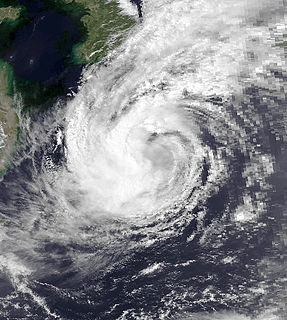
WTyphoon Maemi, known in the Philippines as Typhoon Pogi, was the most powerful typhoon to strike South Korea since record-keeping began in the country in 1904. Maemi formed on September 4, 2003 from a disturbance in a monsoon trough in the western Pacific Ocean. It slowly intensified into Tropical Storm Maemi while moving northwestward, becoming a typhoon on September 8. That day, favorable conditions facilitated more rapid strengthening; the storm developed a well-defined eye and reached peak maximum sustained winds of 195 km/h (120 mph). While near peak intensity, Maemi decelerated and began turning to the north-northeast. Soon after, the eyewall passed over the Japanese island of Miyako-jima on September 10 and produced an air pressure reading of 912 mbar (26.9 inHg), the fourth-lowest recorded in the nation. Due to warm waters, Maemi was able to maintain much of its intensity before it made landfall just west of Busan, South Korea, on September 12. The typhoon became extratropical in the Sea of Japan the next day, although its remnants persisted for several days, lashing northern Japan with strong winds.
 W
WTyphoon Maysak, known in the Philippines as Typhoon Julian, was a deadly, damaging and powerful tropical cyclone that struck the Ryukyu Islands and the Korean Peninsula in September 2020. The third typhoon of the 2020 Pacific typhoon season, Maysak formed from a tropical disturbance. The disturbance gradually organized, receiving the name Julian from PAGASA as it became a tropical depression. As the depression strengthened, the JMA subsequently named the system Maysak. Maysak rapidly intensified into a strong typhoon before weakening and making landfall in South Korea.
 W
WTropical Storm Meari was an unusually large tropical cyclone that caused significant damage from the Philippines to the Korean Peninsula in June 2011.
 W
WTyphoon Nari, known in the Philippines as Typhoon Falcon, was a small but powerful typhoon which struck the Korean Peninsula in early September 2007.
 W
WTyphoon Olga, also known in the Philippines as Typhoon Ising was a typhoon that hit Korean Peninsula in 1999. Olga killed 64 people in North and South Korea.
 W
WTyphoon Prapiroon, known in the Philippines as Typhoon Lusing, was the costliest tropical cyclone to strike the Korean Peninsula and the eighth costliest in the West Pacific on record.
 W
WTyphoon Rammasun, known in the Philippines as Typhoon Florita, was the first of four typhoons to contribute to heavy rainfall and deadly flooding in the Philippines in July 2002. The fifth tropical cyclone of the 2002 Pacific typhoon season, Rammasun developed around the same time as Typhoon Chataan, only further to the west. The storm tracked northwestward toward Taiwan, and on July 2 it attained its peak intensity with winds of 160 km/h (100 mph). Rammasun turned northward, passing east of Taiwan and China. In Taiwan, the outer rainbands dropped rainfall that alleviated drought conditions. In China, the rainfall occurred after previously wet conditions, resulting in additional flooding, although damage was less than expected; there was about $85 million in crop and fishery damage in one province.
 W
WTyphoon Rita, known in the Philippines as Typhoon Gloring, was one of the longest-lived Western Pacific tropical cyclone on record. Rita traversed the basin along an erratic path for 22 days. The second of four simultaneously developing storms, Rita was first identified to the southeast of Guam on July 5, 1972.
 W
WTyphoon Rusa was the most powerful typhoon to strike South Korea in 43 years. It was the 21st JTWC tropical depression, the 15th named storm, and the 10th typhoon of the 2002 Pacific typhoon season. It developed on August 22 from the monsoon trough in the northwestern Pacific Ocean, well to the southeast of Japan. For several days, Rusa moved to the northwest, eventually intensifying into a powerful typhoon. On August 26, the storm moved across the Amami Islands of Japan, where Rusa left 20,000 people without power and caused two fatalities. Across Japan, the typhoon dropped torrential rainfall peaking at 902 mm (35.5 in) in Tokushima Prefecture.
 W
WTyphoon Sally was a powerful tropical cyclone that brought widespread impacts during its week-long trek across the western Pacific in September 1964. It was the most intense typhoon of the 1964 Pacific typhoon season and among the strongest typhoons ever recorded, with one-minute maximum sustained winds of 315 km/h (195 mph) as estimated by the Joint Typhoon Warning Center. Sally first became a tropical cyclone near the Marshall Islands on September 3, organizing into a tropical depression and then a tropical storm later that day. On September 4, Sally intensified into a typhoon and struck southern Guam the next day. Widespread agricultural damage occurred in the island's southern regions, with the banana crop suffering the costliest losses; the damage toll from crops and property exceeded $115,000. Sally continued to intensify on its west-northwestward trek, and reached its peak strength on September 7 over the Philippine Sea.
 W
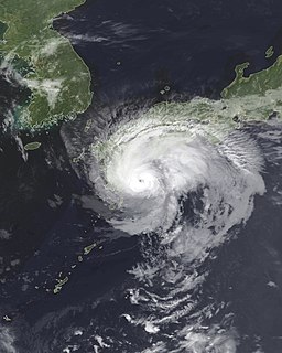
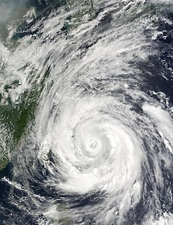
WTyphoon Sanba, known in the Philippines as Typhoon Karen, was the strongest tropical cyclone worldwide in 2012. The sixteenth named storm and tenth typhoon of the annual typhoon season, Sanba formed as a tropical depression east of The Philippines on September 10. The storm gradually intensified as it moved generally northward in an area favorable for tropical development. The system was soon upgraded to a tropical storm less than a day after formation and subsequently further to a typhoon on September 12. Later that day, Sanba entered a phase of explosive intensification, quickly strengthening and gaining annular characteristics. On September 13, the system attained its peak intensity with maximum sustained winds of 125 mph (205 km/h), and a barometric pressure of 900 mbar, becoming the strongest typhoon in the Western Pacific Ocean since Megi in 2010. Accelerating towards more northerly latitudes, a period of gradual weakening ensued afterwards as its eye expanded. It made landfall on South Korea late on September 17 as a typhoon before transitioning into an extratropical cyclone the following day. Sanba's remnants tracked into the Primorsky Krai region of eastern Russia before they were last noted on September 19.
 W
WTyphoon Saomai, known in the Philippines as Typhoon Osang, was a long-tracked and intense tropical cyclone that brought flooding rainfall in Japan and the Korean peninsula in September 2000. The torrential precipitation in Japan was considered some of the worst in the past century.
 W
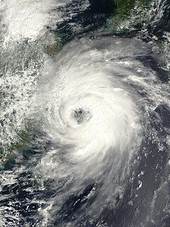
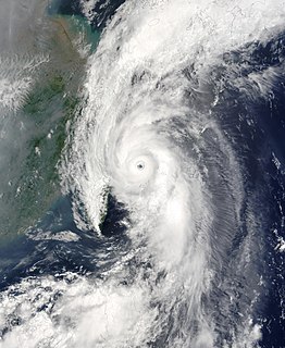
WTyphoon Sarah, as known as the Miyakojima Typhoon in Japan was among the deadliest typhoons on record in the western Pacific Ocean, killing around 2,000 people. It formed during the peak of the busy 1959 Pacific typhoon season near Guam, and moved generally to the west-northwest. Continued observations from the Hurricane Hunters allowed the Joint Typhoon Warning Center (JTWC) to track Sarah from its origins to its peak as a powerful typhoon, with maximum sustained winds estimated at 305 km/h (190 mph) on September 15. Shortly thereafter, the typhoon struck the small Japanese island of Miyako-jima, where the barometric pressure fell to 908.1 mbar (26.82 inHg), the second-lowest on record for the country. Sarah turned to the north and northeast, weakening from its peak intensity. On September 17, the typhoon made landfall just west of Busan, South Korea with winds of 185 km/h (115 mph), the nation's strongest landfall at the time and only to be surpassed by Typhoon Maemi in 2003. Sarah later became extratropical over the Japanese island of Hokkaido on September 18, although the remnants persisted for several days, crossing into the Russian Far East and later dissipating on September 23.
 W
WTyphoon Shanshan, known in the Philippines as Typhoon Luis, was a strong typhoon that affected parts of East Asia in late September 2006. The 13th named storm of the 2006 Pacific typhoon season, Typhoon Shanshan was also the seventh typhoon of the year operationally recognised by the Japan Meteorological Agency. In post-operational analysis Shanshan became the eighth typhoon of the year when Typhoon Maria was added to the list. The Joint Typhoon Warning Center considered Shanshan the 13th tropical storm and eighth typhoon of the season, a Category 4-equivalent typhoon in terms of 1-minute average wind speed. The name Shanshan was submitted to the naming list by Hong Kong and is a girls' given name.
 W
WTyphoon Soudelor, known in the Philippines as Typhoon Egay, was a powerful typhoon that underwent rapid deepening east of Taiwan in the 2003 Pacific typhoon season. It was the sixth named storm by the Japan Meteorological Agency (JMA) of the season, as well as the third typhoon. It formed on June 12 from a disturbance in the monsoon trough, located east of the Philippines. The system moved generally to the northwest after its genesis, gradually intensifying into a tropical storm. While offshore the Philippines, Soudelor dropped heavy rainfall that caused flooding and left thousands homeless. The storm caused $2.46 million in damage, and 12 deaths.
 W
WTyphoon Thelma, known in the Philippines as Typhoon Katring, was the first super typhoon to form in the 1987 Pacific typhoon season. Forming from the monsoon trough in the Philippine Sea, Thelma was first designated as a tropical cyclone on July 7. After moving north, Thelma turned west, while remaining poorly organized. It finally attained typhoon status on July 9, soon after developing an eye, and began to intensify at a brisker clip. During the evening of July 10, Thelma attained maximum intensity while well to the east of the northern Philippines. It also turned sharply northward in response to a trough, slowly weakening. On July 15, Typhoon Thelma, now greatly reduced in intensity, struck the south coast of South Korea. The next day, Thelma rapidly dissipated, shortly after emerging into the Sea of Japan.
 W
WTyphoon Vera, known as Typhoon Loleng in the Philippines, affected Okinawa, China, and South Korea during August 1986. A tropical depression formed on August 13 and attained tropical storm intensity later that day. Initially, Vera meandered in the monsoon trough. On August 17, however, the system abruptly re-formed to east-northeast, and subsequently began to move east and then north. Vera became a typhoon on August 20, and peaked in intensity two days later. Typhoon Vera then turned west-northwest and slowly weakened as it approached Okinawa. After passing near the island, Vera turned north as it tracked east of China. The typhoon made landfall on South Korea on August 28 as a tropical storm, and the next day, transitioned into an extratropical cyclone.