 W
WAERONET - the AERONET is a network of ground-based sun photometers which measure atmospheric aerosol properties. The measurement system is a solar-powered CIMEL Electronique 318A spectral radiometer that measures Sun and sky radiances at a number of fixed wavelengths within the visible and near-infrared spectrum. There is one sea-based reading location aboard the E/V Nautilus, the exploration vessel operated by Dr. Robert Ballard and the Sea Research Foundation. Two readings per day are taken aboard the ship while it is in operation.
 W
WIn aviation, ACARS is a digital datalink system for transmission of short messages between aircraft and ground stations via airband radio or satellite. The protocol was designed by ARINC and deployed in 1978, using the Telex format. More ACARS radio stations were added subsequently by SITA.
 W
WAirport weather stations are automated sensor suites which are designed to serve aviation and meteorological operations, weather forecasting and climatology. Automated airport weather stations have become part of the backbone of weather observing in the United States and Canada and are becoming increasingly more prevalent worldwide due to their efficiency and cost-savings.
 W
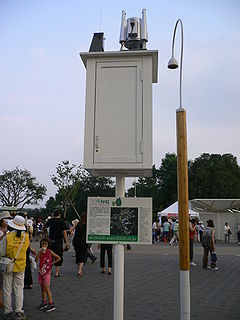
WAMeDAS, commonly known in Japanese as "アメダス" (amedasu), is a high-resolution surface observation network developed by the Japan Meteorological Agency (JMA) used for gathering regional weather data and verifying forecast performance. The system began operating on 1 November 1974, and currently comprises 1,300 stations throughout Japan, with an average separation of 17 km (11 mi).
 W
WThe Citizen Weather Observer Program (CWOP) is a network of privately owned electronic weather stations concentrated in the United States but also located in over 150 countries. Network participation allows volunteers with computerized weather stations to send automated surface weather observations to the National Weather Service (NWS) by way of the Meteorological Assimilation Data Ingest System (MADIS). This data is then used by the Rapid Refresh (RAP) forecast model to produce short term forecasts of conditions across the contiguous United States. Observations are also redistributed to the public.
 W
WA climograph is a graphical representation of a location's basic climate. Climographs display data for two variables: (a) monthly average temperature and (b) monthly average precipitation. These are useful tools to quickly describe a location's climate.
The Community Collaborative Rain, Hail and Snow Network, or CoCoRaHS, is a network of volunteer weather observers in the United States, Canada, and the Bahamas that take daily readings of precipitation and report them to a central data store over the internet.
The NOAA Cooperative Observer Program (COOP) is a citizen weather observer network run by the U.S. National Weather Service (NWS) and National Centers for Environmental Information (NCEI). Over 8,700 volunteers from the fifty states and all territories report at least daily a variety of weather conditions such as daily maximum and minimum temperatures, 24-hour precipitation totals, including snowfall, and significant weather occurrences throughout a day that are recorded via remarks in observer logs. Some stations also report stream stage or tidal levels.
 W
WThe dew point is the temperature to which air must be cooled to become saturated with water vapor. When cooled further, the airborne water vapor will condense to form liquid water (dew). When air cools to its dew point through contact with a surface that is colder than the air, water will condense on the surface.
WThe dew point depression (T-Td) is the difference between the temperature and dew point temperature at a certain height in the atmosphere.
 W
WDoge Weather is a weather forecasting mobile app, web application, and website incorporating the Internet meme Doge.
 W
WThe Dr. Neil Trivett Global Atmosphere Watch Observatory is an atmospheric baseline station operated by Environment and Climate Change Canada located about 6 km (3.7 mi) south south-west of Alert, Nunavut, on the north-eastern tip of Ellesmere Island, about 800 km (500 mi) south of the geographic North Pole.
 W
WThe Facility for Airborne Atmospheric Measurements (FAAM), based on the Cranfield University campus alongside Cranfield Airport in Bedfordshire, England, is an organisation formed by a collaboration between the Met Office and the Natural Environment Research Council (NERC).
 W
WFerret is an interactive computer visualization and analysis environment designed to meet the needs of oceanographers and meteorologists analyzing large and complex gridded data sets. Ferret offers a Mathematica-like approach to analysis; new variables may be defined interactively as mathematical expressions involving data set variables. Calculations may be applied over arbitrarily shaped regions. Fully documented graphics are produced with a single command. It runs on most Unix and Linux systems using X Window for display, and on Windows XP/NT/9x.
FLUXNET is a global network of micrometeorological tower sites that use eddy covariance methods to measure the exchanges of carbon dioxide, water vapor, and energy between the biosphere and atmosphere. FLUXNET is a global 'network of regional networks' that serves to provide an infrastructure to compile, archive and distribute data for the scientific community. It works to ensure that different flux networks are calibrated to facilitate comparison between sites, and it provides a forum for the distribution of knowledge and data between scientists.
The Global Atmosphere Watch (GAW) is a worldwide system established by the World Meteorological Organization – a United Nations agency – to monitor trends in the Earth's atmosphere. It arose out of concerns for the state of the atmosphere in the 1960s.
 W
WHDF Explorer is a data visualization program that reads the HDF, HDF5 and netCDF data file formats. It runs in the Microsoft Windows operating systems. HDF Explorer was developed by Space Research Software, LLC, headquartered in Urbana-Champaign, Illinois.
Hierarchical Data Format (HDF) is a set of file formats designed to store and organize large amounts of data. Originally developed at the National Center for Supercomputing Applications, it is supported by The HDF Group, a non-profit corporation whose mission is to ensure continued development of HDF5 technologies and the continued accessibility of data stored in HDF.
 W
WThe inshore coastal areas of the United Kingdom are 15 fixed stretches of coastline that are used in weather forecasting especially for wind-powered or small coastal craft. Each area is delimited by geographical features such as headlands, seaports or estuaries. When used as part of a broadcast weather forecast they are mentioned in the same order, clockwise round the mainland starting and finishing in the north west of the island of Great Britain. The Isle of Man is included in the forecasts but it is not part of the United Kingdom.
 W
WThe International Comprehensive Ocean-Atmosphere Data Set (ICOADS) is a digital database of 261 million weather observations made by ships, weather ships, and weather buoys spanning the years 1662 to 2007. The database was initially constructed in 1985 and continues to be expanded upon and updated on a regular basis. From the original data, gridded datasets were created. ICOADS information has been useful in determining the reliability of ship and buoy wind measurements, helping to determine temperature trends in the sea surface temperature field, and updating the Atlantic hurricane database.
 W
WReports from these coastal stations and automatic weather logging stations in the British Isles are included in the extended Shipping Forecasts on BBC Radio 4 at 0048 and 0520 local time each day.
 W
WA low-level windshear alert system (LLWAS) measures average surface wind speed and direction using a network of remote sensor stations, situated near runways and along approach or departure corridors at an airport. Wind shear is the generic term for wind differences over an operationally short distance which encompass meteorological phenomena including gust fronts, microbursts, vertical shear, and derechos.
 W
WIn meteorology, a mesonet, portmanteau of mesoscale network, is a network of (typically) automated weather and environmental monitoring stations designed to observe mesoscale meteorological phenomena. Dry lines, squall lines, and sea breezes are examples of phenomena that can be observed by mesonets. Due to the space and time scales associated with mesoscale phenomena, weather stations comprising a mesonet will be spaced closer together and report more frequently than synoptic scale observing networks, such as ASOS. The term mesonet refers to the collective group of these weather stations, and are typically owned and operated by a common entity. Mesonets usually record in situ surface weather observations but some involve other observation platforms, particularly vertical profiles of the planetary boundary layer (PBL).
 W
WOld Weather is an online weather data project that currently invites members of the public to assist in digitising weather observations recorded in US log books dating from the mid-19th century onwards. It is an example of citizen science that enlists members of the public to help in scientific research. It contributes to the Atmospheric Circulation Reconstructions over the Earth initiative. Data collected by Old Weather has been used by at least five different climate reanalysis projects, including HURDAT, SODA and ECMWF. In February 2013, the project was awarded the Royal Meteorological Society IBM Award for Meteorological Innovation that Matters.
OpenWeatherMap is an online service, owned by OpenWeather Ltd, that provides global weather data, including current weather data, forecasts, nowcasts and historical data, utilising meteorological broadcast services and raw data from airport weather stations, radar stations and other weather stations.
 W
WMS Polarfront was a Norwegian weather ship located in the North Atlantic Ocean. It was the last remaining weather ship in the world, maintained by the Norwegian Meteorological Institute.
 W
WPRECIS is developed at the Hadley Centre at the UK Met Office, PRECIS is a regional climate modelling system designed to run on a Linux-based PC. PRECIS can be applied to any area of the globe to generate detailed climate change projections.
PressureNET was a crowd-sourced reporting network for barometric pressure data.
 W
WSkywarn is a program of the National Weather Service (NWS). Its mission is to collect reports of localized severe weather in the United States. These reports are used to aid forecasters in issuing and verifying severe weather watches and warnings and to improve the forecasting and warning processes and the tools used to collect meteorological data. Reports are also used by local emergency managers and public safety organizations.
 W
WStation P is an ocean measurement site, located at 50 degrees north latitude, 145 degrees west longitude.
 W
WSurface weather observations are the fundamental data used for safety as well as climatological reasons to forecast weather and issue warnings worldwide. They can be taken manually, by a weather observer, by computer through the use of automated weather stations, or in a hybrid scheme using weather observers to augment the otherwise automated weather station. The ICAO defines the International Standard Atmosphere (ISA), which is the model of the standard variation of pressure, temperature, density, and viscosity with altitude in the Earth's atmosphere, and is used to reduce a station pressure to sea level pressure. Airport observations can be transmitted worldwide through the use of the METAR observing code. Personal weather stations taking automated observations can transmit their data to the United States mesonet through the Citizen Weather Observer Program (CWOP), the UK Met Office through their Weather Observations Website (WOW), or internationally through the Weather Underground Internet site. A thirty-year average of a location's weather observations is traditionally used to determine the station's climate. In the US a network of Cooperative Observers make a daily record of summary weather and sometimes water level information.
 W
WThe Todd Weather Folios are a collection of continental Australian synoptic charts that were published from 1879 to 1909.
 W
WVis5D is a 3D visualization system used primarily for animated 3D visualization of weather simulations. It was the first system to produce fully interactive animated 3D displays of time-dynamic volumetric data sets and the first open source 3D visualization system. It is GNU GPL licensed.
 W
WWeather buoys are instruments which collect weather and ocean data within the world's oceans, as well as aid during emergency response to chemical spills, legal proceedings, and engineering design. Moored buoys have been in use since 1951, while drifting buoys have been used since 1979. Moored buoys are connected with the ocean bottom using either chains, nylon, or buoyant polypropylene. With the decline of the weather ship, they have taken a more primary role in measuring conditions over the open seas since the 1970s. During the 1980s and 1990s, a network of buoys in the central and eastern tropical Pacific Ocean helped study the El Niño-Southern Oscillation. Moored weather buoys range from 1.5–12 metres (5–40 ft) in diameter, while drifting buoys are smaller, with diameters of 30–40 centimetres (12–16 in). Drifting buoys are the dominant form of weather buoy in sheer number, with 1250 located worldwide. Wind data from buoys has smaller error than that from ships. There are differences in the values of sea surface temperature measurements between the two platforms as well, relating to the depth of the measurement and whether or not the water is heated by the ship which measures the quantity.
The Weather Channel (TWC) is an American pay television channel owned by the Weather Group, LLC, a subsidiary of the Allen Media Group. The channel's headquarters are in Atlanta, Georgia. Launched on May 2, 1982, the channel broadcasts weather forecasts and weather-related news and analysis, along with documentaries and entertainment programming related to weather. A sister network, Weatherscan, is a digital cable and satellite service that offers 24-hour automated local forecasts and radar imagery.
Weather Underground is a commercial weather service providing real-time weather information over the Internet. Weather Underground provides weather reports for most major cities across the world on its Web site, as well as local weather reports for newspapers and third-party sites. Its information comes from the National Weather Service (NWS), and over 250,000 personal weather stations (PWS). The site is available in many languages, and customers can access an ad-free version of the site with additional features for an annual fee. Weather Underground is owned by The Weather Company, a subsidiary of IBM.
WThe wet-bulb temperature (WBT) is the temperature read by a thermometer covered in water-soaked cloth over which air is passed. At 100% relative humidity, the wet-bulb temperature is equal to the air temperature ; at lower humidity the wet-bulb temperature is lower than dry-bulb temperature because of evaporative cooling.
Weather Underground / HeavyWeather Uploader, commonly WUHU, is a free software package for Microsoft Windows which allows users with Personal Weather Stations to contribute weather data to one of several networks, including:Weather Underground (wunderground.com) Citizen Weather Observer Program WeatherBug YoWindow Australian Weather Network UK Weather Net
 W
Wyr.no is a website and a mobile app for weather forecasting and dissemination of other types of meteorological information hosted by the Norwegian Broadcasting Corporation in collaboration with the Norwegian Meteorological Institute. The website was officially launched in september 2007.