 W
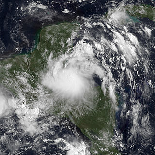
WTropical Depression Twelve-E was a short-lived but deadly tropical cyclone that dropped heavy rainfall across large portions of Central America in October 2011. It formed from a tropical disturbance roughly hundred miles south of Mexico, which fluctuated in organization for several days. By October 12, the National Hurricane Center (NHC) deemed the associated low pressure-area well defined enough for it to be considered a tropical depression. After attaining peak wind speeds of 35 mph (55 km/h), the depression moved ashore between Salina Cruz, Oaxaca, and Arriaga, Chiapas. It caused significant flooding and at least 30 fatalities in the region.
 W
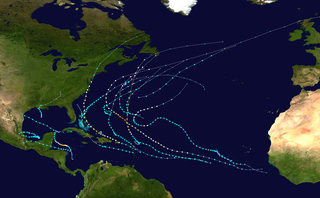
WThe 2011 Atlantic hurricane season was the second in a group of three very active Atlantic hurricane seasons. The above-average activity was mostly due to a La Niña that persisted during the previous year. The season is tied with 1887, 1995, 2010, and 2012 for the fourth highest number of tropical storms since record-keeping began in 1851. Although the season featured 19 tropical storms, most were weak. Only seven of them intensified into hurricanes, and only four of those became major hurricanes: Irene, Katia, Ophelia, and Rina. The season officially began on June 1 and ended on November 30, dates which conventionally delimit the period during each year in which most tropical cyclones develop in the Atlantic Ocean. However, the first tropical storm of the season, Arlene, did not develop until nearly a month later. The final system, Tropical Storm Sean, dissipated over the open Atlantic on November 11.
WThe 2011 Atlantic hurricane season was an event in the annual hurricane season in the north Atlantic Ocean. It was well above average in the number of tropical cyclones that formed, at 19. Even so, it was the first season on record in which the first eight storms failed to attain hurricane strength. The season officially began on June 1, 2011, and ended on November 30, 2011, dates that conventionally delimit the period of each year when most tropical cyclones develop in the Atlantic basin. The season's first storm, Tropical Storm Arlene did not form until June 28. The final storm to develop, Tropical Storm Sean, dissipated on November 11.
 W
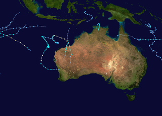
WThe 2010–11 Australian region cyclone season was a near average tropical cyclone season, with eleven tropical cyclones forming compared to an average of 12. The season was also the costliest recorded in the Australian region basin, with a total of $3.62 billion in damages, mostly from the destructive Cyclone Yasi. The season began on 1 November 2010 and ended on 30 April 2011, although the first tropical cyclone formed on 28 October. The Australian region is defined as being to the south of the equator, between the 90th meridian east and 160th meridian east. Tropical cyclones in this area are monitored by five Tropical Cyclone Warning Centres (TCWC's): Jakarta, Port Moresby, Perth, Darwin, and Brisbane, each of which have the power to name a tropical cyclone. The TCWC's in Perth, Darwin, and Brisbane are run by the Bureau of Meteorology, who designate significant tropical lows with a number and the U suffix. The Joint Typhoon Warning Center also issues unofficial warnings for the region, designating significant tropical cyclones with the "S" suffix when they form west of 135°E, and the "P" suffix when they form east of 135°E.
 W
WThe 2011–12 Australian region cyclone season was a below average tropical cyclone season, with 7 cyclones forming rather than the usual 11. It began on 1 November 2011, and ended on 14 May 2012. The regional tropical cyclone operational plan defines a "tropical cyclone year" separately from a "tropical cyclone season"; the "tropical cyclone year" began on 1 July 2011 and ended on 30 June 2012.
 W
WThe 2011 Pacific hurricane season was a below average season in terms of named storms and hurricanes, although it had an above average number of major hurricanes. During the season, 13 tropical depressions formed along with 11 tropical storms, 10 hurricanes and six major hurricanes. The season officially began on May 15 in the East Pacific Ocean, and on June 1 in the Central Pacific; they ended on November 30. These dates conventionally delimit the period of each year when most tropical cyclones form in the Pacific basin. However, the formation of tropical cyclones is possible at any time of the year.
WThe 2011 Pacific hurricane season officially started on May 15, 2011 in the eastern Pacific, designated as the area east of 140°W, and on June 1, 2011 in the central Pacific, which is between the International Date Line and 140°W, and lasted until November 30, 2011. These dates typically limit the period of each year when most tropical cyclones form in the eastern Pacific basin. This timeline documents all the storm formations, strengthening, weakening, landfalls, extratropical transitions, as well as dissipation.
 W
WThe 2011 North Indian Ocean cyclone season was the least active tropical cyclone season in the North Indian Ocean since 1993. Only two cyclonic storms formed, below the average of four to six. The North Indian Ocean cyclone season has no official bounds, but cyclones tend to form between April and December, with peaks in May and November. These dates conventionally delimit the period of each year when most tropical cyclones form in the northern Indian Ocean. The scope of this article is limited to the Indian Ocean in the Northern Hemisphere, east of the Horn of Africa and west of the Malay Peninsula. There are two main seas in the North Indian Ocean — the Arabian Sea to the west of the Indian subcontinent, abbreviated ARB by the India Meteorological Department (IMD); and the Bay of Bengal to the east, abbreviated BOB by the IMD.
 W
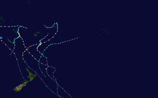
WThe 2010–11 South Pacific cyclone season was an average tropical cyclone season, with seven tropical cyclones and five severe tropical cyclones developing during the season. The season ran from November 1, 2010 until April 30, 2011, though if any tropical cyclones had developed between July 1, 2010 and June 30, 2011, the official tropical cyclone year, they would have been counted towards the season's total. Within the South Pacific basin tropical cyclones were officially monitored by the Fiji Meteorological Service's Regional Specialized Meteorological Center in Nadi, Fiji, north of 25°S, and to the south the Meteorological Service of New Zealand's Tropical Cyclone Warning Center in Wellington, New Zealand. Any disturbances forming in the region were designated with a sequential number suffixed by the letter F. In addition, the United States Military's Joint Typhoon Warning Center unofficially monitored parts of the basin during the season, where any systems judged to have achieved tropical storm strength or greater received a number suffixed with the letter P. RSMC Nadi and TCWC Wellington both use the Australian Tropical Cyclone Intensity Scale, and measure wind speeds over a period of ten minutes, while the JTWC measures sustained winds over a period of one minute which can be applied to the Saffir–Simpson Hurricane Scale. Seven named storms formed or moved into the South Pacific basin during the 2010–11 season, the strongest of which was Severe Tropical Cyclone Wilma in late January.
 W
WThe 2011–12 South Pacific cyclone season was one of the least active South Pacific tropical cyclone seasons on record, with only three tropical cyclones occurring during the season. The season ran from November 1, 2011 to April 30, 2012, however, any tropical cyclones that form before June 30, 2012 would have fallen within the 2011–12 tropical cyclone year and would have counted towards the season total. The strongest and only severe tropical cyclone that occurred during the season was Severe Tropical Cyclone Jasmine, which tracked in from out of the South Pacific basin. Within the basin, tropical cyclones are monitored by the Regional Specialized Meteorological Center (RSMC) in Nadi, Fiji, and the Tropical Cyclone Warning Center (TCWC) in Wellington, New Zealand. RSMC Nadi attaches an F designation to tropical disturbances that form in or move into the South Pacific. The United States Joint Typhoon Warning Center (JTWC) issues unofficial warnings within the South Pacific, designating tropical storm-equivalent or greater tropical cyclones with a number and a P suffix. RSMC Nadi and TCWC Wellington both use the Australian Tropical Cyclone Intensity Scale, and measure windspeeds over a period of ten minutes, while the JTWC measures sustained winds over a period of one minute and uses the Saffir–Simpson Hurricane Scale.
 W
WThe 2010–11 South-West Indian Ocean cyclone season was the least active cyclone season on record in the basin, tied with 1982–83, producing only three systems of gale intensity. This was due to cooler than normal water temperatures and the Walker circulation – a broad atmospheric circulation – causing unusually moist conditions in the eastern Indian Ocean and unusually dry conditions in the western Indian Ocean. The basin includes the waters of the ocean south of the equator and west of 90º E to the eastern coast of Africa.
 W
WThe 2011–12 South-West Indian Ocean cyclone season was a slightly above average event in tropical cyclone formation. It began on November 15, 2011, and ended on April 30, 2012, with the exception for Mauritius and the Seychelles, for which it ended on May 15, 2012. These dates conventionally delimit the period of each year when most tropical cyclones form in the region; however, Severe Tropical Storm Kuena developed in early June after the season had officially ended. The basin is defined as the area west of 90°E and south of the Equator in the Indian Ocean, which includes the waters around Madagascar westward to the east coast of Africa. Tropical cyclones in this basin are monitored by the Regional Specialised Meteorological Centre in Réunion.
 W
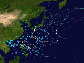
WThe 2011 Pacific typhoon season was a below average season that produced a total of 21 named storms, 8 typhoons, and four super typhoons. This season was much more active than the previous season, although both seasons were below the Pacific typhoon average of 26. The season ran throughout 2011, though most tropical cyclone tend to develop between May and October. The season's first named storm, Aere, developed on May 7 while the season's last named storm, Washi dissipated on December 19.
WThis timeline documents all of the events of the 2011 Pacific typhoon season, the period that tropical cyclones formed in the Western Pacific Ocean in 2011. Most of the tropical cyclones formed between May and November 2011. The scope of this article is limited to the Pacific Ocean, north of the equator between 100°E and the International Date Line. Tropical storms that form in the entire Western Pacific basin are assigned a name by the Japan Meteorological Agency (JMA). Tropical depressions that form in this basin are given a number with a "W" suffix by the United States' Joint Typhoon Warning Center (JTWC). In addition, the Philippine Atmospheric, Geophysical and Astronomical Services Administration (PAGASA) assigns names to tropical cyclones that enter or form in the Philippine area of responsibility. These names, however, are not in common use outside of the Philippines.
 W
WHurricane Adrian was an intense, albeit short-lived early-season category 4 hurricane that brought heavy rainfall and high waves to Mexico in June 2011 during the 2011 Pacific hurricane season. Adrian originated from an area of disturbed weather which had developed during the course of early June, off the Pacific coast of Mexico. On June 7, it acquired a sufficiently organized structure with deep convection to be classified as a tropical cyclone, and the National Hurricane Center (NHC) designated it as Tropical Depression One-E, the first one of 2011. It further strengthened to be upgraded into a tropical storm later that day. Adrian moved rather slowly; briefly recurving northward after being caught in the steering winds. After steady intensification, it was upgraded into a hurricane on June 9. The storm subsequently entered a phase of rapid intensification, developing a distinct eye with good outflow in all quadrants. Followed by this period of rapid intensification, it obtained sustained winds fast enough to be considered a major hurricane and reached its peak intensity as a category 4 hurricane that evening.
 W
WTropical Storm Aere, known in the Philippines as Tropical Storm Bebeng, was a mild tropical storm that affected eastern Philippines and southern Japan. It was the first named storm of the 2011 Pacific typhoon season. Aere is the Marshallese word for storm.
 W
WTropical Storm Arlene, the first named storm of the 2011 Atlantic hurricane season, brought blustery conditions to much of eastern Mexico in late June to early July 2011. Arlene originated from an Atlantic tropical wave, which crossed the Yucatán Peninsula before emerging over warm waters in the Bay of Campeche. Despite moderate wind shear, the disturbance strengthened and developed a surface circulation, prompting the National Hurricane Center to declare it a tropical storm on June 28. Arlene remained vigorous for most of its existence; the storm peaked in intensity with winds of 65 mph (100 km/h) on June 30, just before making landfall on the coast of Veracruz. Crossing the mountains of eastern Mexico, Arlene weakened to a depression before dissipating early on July 1.
 W
WHurricane Beatriz was a Category 1 hurricane that killed four people after brushing the western coast of Mexico in June 2011. Originating from an area of disturbed weather on June 19, several hundred miles south of Mexico, Beatriz gradually intensified. Gaining latitude, the system became increasingly organized and reached hurricane status on the evening of June 20. The following morning, Beatriz attained winds of 90 mph (150 km/h) as it passed roughly 15 mi (20 km) of Mexico. Due to its interaction with land, the hurricane abruptly weakened hours later. Early on June 22, Beatriz dissipated over open waters. Prior to Beatriz's arrival in Mexico, hurricane watches and warnings were issued for coastal areas. Hundreds of shelters opened across the states of Colima and Guerrero. Heavy rains from the storm triggered significant flooding along the Sabana River in Acapulco, killing four people. However, the overall effects of Beatriz were limited and the rains were largely beneficial in mitigating a severe drought.
 W
WTropical Cyclone Bingiza was the only named storm to make landfall in the inactive 2010–11 South-West Indian Ocean cyclone season. The second of three storms, Bingiza developed on February 9 to the northeast of Madagascar. For a few days it meandered generally southwestward, failing to intensify significantly. On February 12, the storm began a steady westward track as environmental conditions became more favorable. In a 24‑hour period, Bingiza developed from a moderate tropical storm into an intense tropical cyclone with a well-defined eye. After attaining peak 10–minute sustained winds of 155 km/h (100 mph), the cyclone moved ashore in northeastern Madagascar on February 14 and quickly weakened as it crossed the country. Bingiza emerged into the Mozambique Channel as a weak tropical disturbance, and it turned southward to move across western Madagascar. Bingiza attained tropical storm status before making its final landfall near Morondava, degenerating into a remnant low on February 17, and dissipating two days later.
 W
WTropical Storm Bret was the second named storm of the 2011 Atlantic hurricane season. Bret formed along the southwestern periphery of a weather front north of the Bahamas on July 17. At first, the storm moved little and gradually strengthened in response to favorable upper-level conditions, reaching peak sustained winds of 70 mph (110 km/h). Steering currents in the area subsequently became better established, and Bret turned toward the northeast only to encounter a substantial increase in vertical wind shear. Despite the shear, the storm maintained a well-defined wind circulation for several days, with intermittent bursts of thunderstorms near its center. By July 22, Bret had been devoid of strong thunderstorm activity for several hours, prompting the National Hurricane Center to discontinue public advisories when it was located about 375 miles (605 km) north of Bermuda.
 W
WTropical Storm Don was the first tropical cyclone to make landfall in the United States during the 2011 season. The fourth named storm of the 2011 Atlantic hurricane season, Tropical Storm Don formed from an area of low pressure along a tropical wave, Don developed into a tropical depression on July 27, and on that same day, was upgraded to tropical storm intensity, based on data from a reconnaissance aircraft noted the presence of tropical-storm-force winds. It tracked across the Gulf of Mexico and reached a peak intensity of 50 mph (85 km/h) before moving ashore in Texas on July 30 as a tropical depression, dissipating shortly afterwards. Initially, Don was expected to provide relief to the state, which was suffering from a major drought. However, the system dissipated rapidly just before making landfall, providing very little in the way of help to the state; rainfall totals were less than 1 in.
 W
WHurricane Dora was the strongest tropical cyclone in the northeastern Pacific in 2011. Dora developed from a tropical wave south of Honduras on July 18. Moving northwestward in favorable conditions, the system quickly intensified to tropical storm status and attained hurricane intensity the next day. Rapid intensification ensued shortly thereafter, bringing the storm to its peak intensity on July 21 as a Category 4 hurricane, with a minimum barometric pressure of 929 mbar and maximum sustained winds of 155 mph (250 km/h). However, the storm's path into an area with cool sea surface temperatures and wind shear caused Dora to quickly deteriorate and weaken. By July 24, Dora had degenerated into a remnant low-pressure area west of the Baja California Peninsula. Dora brought stormy conditions to the southwestern Mexico coast and the Baja California Peninsula throughout its existence. Remaining off the coast from its formation to dissipation, Dora's effects on land were slight. However, the outer rainbands of the hurricane caused flooding and mudslides in southern Mexico and Guatemala, while rough surf toppled a lighthouse and damaged 60 restaurants along the coast. The hurricane's remnants contributed to heightened shower and thunderstorm activity across New Mexico and Arizona in late July.
 W
WTropical Storm Emily was a weak Atlantic tropical cyclone that brought torrential rains to much of the northern Caribbean in 2011. The fifth named storm of the annual hurricane season, Emily developed from a strong but poorly organized tropical wave that traversed the open Atlantic over the last week July. On August 1, it approached the Lesser Antilles and became more consolidated, producing inclement weather over many of the northern islands. Two days later, the disturbance’s wind flow became more cyclonic with a defined center of circulation, which marked the formation of Tropical Storm Emily. The storm remained fairly irregular in structure, though generating strong thunderstorms and gusty winds along its path over the Caribbean Sea. On August 4, Emily was declassified as a tropical cyclone after the mountainous areas of Hispaniola further disrupted its diffuse circulation. Upon exiting the northeastern Caribbean on August 6, its remnants briefly regenerated into a tropical storm before dissipating completely the next day.
 W
WCyclone Grant was a tropical cyclone that affected Queensland and the Northern Territory in late December 2011 and early January 2012.
 W
WTropical Storm Harvey was the final tropical cyclone in a record-breaking string of eight consecutive storms that failed to attain hurricane intensity. The eighth tropical cyclone and eighth named storm of the 2011 Atlantic hurricane season, Harvey developed from a tropical wave in the western Caribbean Sea on August 19. It moved over warm waters in the vicinity of Central America. Later on August 19, the system strengthened into Tropical Storm Harvey while just offshore Honduras. Additional organization occurred and Harvey attained its peak intensity of 65 mph (100 km/h) prior to coming ashore Belize on August 20. Harvey weakened to a tropical depression on August 21, but re-intensified to a tropical storm after emerging into the Bay of Campeche. Early on August 22, it made landfall in Veracruz, then weakened and dissipated several hours later.
 W
WHurricane Hilary was a powerful tropical cyclone that caused significant flooding in southwestern Mexico in late September 2011. The fourth Category 4 and major hurricane, seventh hurricane, and eighth tropical storm of the 2011 Pacific hurricane season, Hilary developed from an area of low pressure off the Pacific coast of Central America in mid-September. Organizing quickly, the system became a tropical depression on September 21, after gaining enough organization to be declared as such. While moving towards the west-northwest, the depression continued to gather strength and was subsequently upgraded to a tropical storm just several hours later. On September 21, Hilary was declared as a Category 1 hurricane, while located close to the Mexican coastline, where the storm brought heavy rainfall and flooding. Undergoing rapid intensification, Hilary strengthened into a Category 4 hurricane on September 22, recognized with a distinct eye feature. Beginning to enter cooler Ocean temperatures, Hilary began to weaken by September 25 but briefly restrengthened into a Category 4 the following day. Atmospheric conditions became increasingly unfavorable late on September 26, and the system began to weaken. During the afternoon hours of September 30, Hilary became a remnant low, while located several hundred miles away from any landmasses.
 W
WHurricane Irene was a large and destructive tropical cyclone which affected much of the Caribbean and East Coast of the United States during late August 2011. The ninth named storm, first hurricane, and first major hurricane of the 2011 Atlantic hurricane season, Irene originated from a well-defined Atlantic tropical wave that began showing signs of organization east of the Lesser Antilles. Due to development of atmospheric convection and a closed center of circulation, the system was designated as Tropical Storm Irene on August 20, 2011. After intensifying, Irene made landfall in St. Croix as a strong tropical storm later that day. Early on August 21, the storm made a second landfall in Puerto Rico. While crossing the island, Irene strengthened into a Category 1 hurricane. The storm paralleled offshore of Hispaniola, continuing to slowly intensify in the process. Shortly before making four landfalls in the Bahamas, Irene peaked as a 120 mph (190 km/h) Category 3 hurricane.
 W
WThe effects of Hurricane Irene in New Jersey in 2011 included about $1 billion in damage to 200,000 homes and buildings. This made it the costliest disaster in the state's history, though this was dwarfed by Hurricane Sandy the following year. Irene struck the state on August 28, and was initially reported to be the first hurricane to hit New Jersey since 1903; however, post-analysis downgraded Irene to a tropical storm at its landfall in the Little Egg Inlet.
WThe Effects of Hurricane Irene in New York were the worst from a hurricane since Hurricane Agnes in 1972. Hurricane Irene formed from a tropical wave on August 21, 2011 in the tropical Atlantic Ocean. It moved west-northwestward, and within an environment of light wind shear and warm waters. Shortly before becoming a hurricane, Irene struck Puerto Rico as a tropical storm. Thereafter, it steadily strengthened to reach peak winds of 120 mph (195 km/h) on August 24. Irene then gradually weakened and made landfall on the Outer Banks of North Carolina with winds of 85 mph (140 km/h) on August 27. It slowly weakened over land and re-emerged into the Atlantic on the following day. Later on August 28, Irene was downgraded to a tropical storm and made two additional landfalls, one in New Jersey and another in New York. The storm quickly began to lose tropical characteristics and became extratropical in Vermont.
 W
WHurricane Jova was a strong Pacific hurricane that made landfall over Jalisco, Mexico. The tenth tropical depression and named storm, ninth hurricane, and fifth major hurricane of the 2011 Pacific hurricane season, Jova developed from an area of showers and thunderstorms that became better organized in early October. Moving towards the west-northwest, the area became better organized, and late on October 5, the National Hurricane Center began issuing advisories on Tropical Depression Ten-E. Steadily organizing, the storm was upgraded to Tropical Storm Jova later the following day, and by October 8, the storm had been classified as a Category 1 hurricane on the Saffir-Simpson hurricane scale. The storm attained Category 2 hurricane status late on October 9, and after a round of rapid intensification early on October 10, Jova had become a major hurricane.
 W
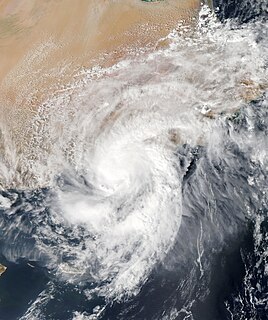
WCyclonic Storm Keila was the first named storm of the 2011 North Indian Ocean cyclone season. A weak system for much of its duration, Keila developed in the western Arabian Sea in late October 2011, amid an area of marginally favorable conditions. On November 2, it briefly organized enough to be classified as a cyclonic storm, which has maximum sustained winds of at least 65 km/h (40 mph). Given the name Keila by the India Meteorological Department (IMD), the storm quickly moved ashore southern Oman near Salalah, and weakened while meandering over the country. The remnants soon after moved offshore, dissipating on November 4.
 W
WTropical Storm Lee was the thirteenth named storm and fifteenth system overall of the 2011 Atlantic hurricane season, developing from a broad tropical disturbance over the gulf on September 1. It was designated as Tropical Storm Lee the next day. Prior to 2020, when Marco formed on August 22, Lee was tied with 2005's Maria as the earliest-forming 13th Atlantic tropical storm. The system was rather large, and due to drifting, Lee brought flash flooding to the Gulf Coast. Flooding associated with the rains caused significant property damage in the areas, with drowning deaths reported in both Mississippi and Georgia. Elsewhere, the storm helped spread wildfires that destroyed homes and killed two people in Texas, and a traffic accident in Alabama resulted in one death. Rough surf offshore drowned one person in each of these states. Lee spawned 30 confirmed tornadoes in the United States. After becoming extratropical, Lee caused historic flooding in Pennsylvania, New York, and Canada, mainly Quebec and Ontario.
 W
WTyphoon Ma-on, known in the Philippines as Typhoon Ineng, was a large and powerful typhoon that affected southern Japan in July 2011. It was the sixth named storm and second typhoon of the 2011 Pacific typhoon season. Originating from an area of low pressure near Wake Island on July 9, the precursor to Ma-on gradually developed as it moved westward. By July 11, it had become sufficiently organized to be declared a tropical depression, although the cyclone's circulation remained broad. Over the following days, Ma-on gradually intensified and attained typhoon status on July 14. Favorable environmental conditions allowed for additional strengthening, and the storm ultimately attained peak ten-minute sustained winds of 175 km/h (110 mph) on July 16. After turning northward in response to a weakening subtropical ridge, the typhoon underwent a series of eyewall replacement cycles that caused it to weaken. On July 19, Ma-on struck Shikoku before turning southeastward and moving back over water. Slow weakening continued as Ma-on succumbed to the effects of high wind shear. The system ultimately became extratropical on July 24, and was last noted by the Japan Meteorological Agency a week later near the Kamchatka Peninsula.
 W
WHurricane Maria was a Category 1 hurricane that made landfall on the island of Newfoundland during September 2011. Originating from a tropical wave over the central Atlantic on September 6, Maria moved toward the west and slowly strengthened. While approaching the northern Leeward Islands, however, the system entered a region of higher vertical wind shear and cooler sea surface temperatures, causing it to degenerate into a low-pressure area. It slowly curved toward the north and northeast around the western periphery of the subtropical ridge, and regained tropical storm status on September 10. Maria further strengthened to attain hurricane status while making its closest approach to Bermuda. The cyclone attained peak winds of 80 mph (130 km/h) on September 16, but weakened thereafter because of an increase in wind shear and cooler sea surface temperatures. Maria made landfall on the southeastern coast of Newfoundland during the afternoon hours of September 16 before becoming absorbed by a frontal system later on that same day.
 W
WTyphoon Muifa, known in the Philippines as Typhoon Kabayan, was a large, powerful and persistent typhoon which affected a number of countries in the Pacific, killing 22 and causing widespread damage worth US$480 million. It was the ninth named storm, third typhoon and the second super-typhoon of the 2011 Pacific typhoon season.
 W
WTyphoon Nalgae, known in the Philippines as Typhoon Quiel, was a powerful tropical cyclone that struck the Philippines, and it affected Hainan, China as a weak tropical storm. Nalgae was the eighth typhoon and the fourth super typhoon in 2011. Forming as the 32nd tropical depression of the season, the system formed on September 26 over the Philippine Sea. On September 27, it was named Nalgae as it explosively intensified into a typhoon on the next day. Nalgae reached its peak intensity as a Category 4 typhoon on September 30 while it made landfall over Luzon. Nalgae weakened into a tropical storm as it entered the South China Sea on October 1. Nalgae made landfall over the island of Guandong in China on October 4 as it weakened to a tropical depression. Nalgae dissipated on October 5 east of Vietnam.
 W
WTyphoon Nanmadol, known in the Philippines as Typhoon Mina, was the strongest tropical cyclone in 2011 to hit the Philippines and also the first of the year to directly impact Taiwan and the rest of the Republic of China (ROC). It was the eleventh named storm, the seventh severe tropical storm and the fourth typhoon of the 2011 Pacific typhoon season. Nanmadol made a total of three landfalls killing 26, and causing widespread damage worth US$26,464,591. The name Nanmadol is derived from Nan Madol, a ruined city that lies off the eastern shore of the island of Pohnpei that was the capital of the Saudeleur dynasty until about AD 1500.
 W
WTyphoon Nesat, known in the Philippines as Typhoon Pedring, was the most powerful tropical cyclone to directly impact China since 2005. It also struck the Philippines during the 2011 Pacific typhoon season, killing 83 people. It is the 17th named storm, the 11th severe tropical storm, the 7th typhoon and overall, the 30th tropical cyclone to be monitored by the Japan Meteorological Agency(JMA) during the year. Nesat came exactly two years after Typhoon Ketsana made landfall in the Philippines as the most devastating typhoon in the 2009 Pacific typhoon season with a damage of US$1.09 billion and 747 fatalities. Nesat was also the first of twin tropical cyclones to batter the Philippines within one week during September 2011, the second was Nalgae.
 W
WSevere Tropical Storm Nock-ten, known in the Philippines as Tropical Storm Juaning, was a strong tropical storm which made a total of four landfalls in Southeast Asia, killing more than 100 people and causing damage estimated at US$126 million. It was the eighth named storm and the fourth severe tropical storm of the 2011 Pacific typhoon season.
 W
WHurricane Ophelia was the most intense hurricane of the 2011 Atlantic hurricane season. The seventeenth tropical cyclone, sixteenth tropical storm, fifth hurricane, and third major hurricane, Ophelia originated in a tropical wave in the central Atlantic, forming approximately midway between the Cape Verde Islands and the Lesser Antilles on September 17. Tracking generally west-northwestward, Ophelia was upgraded to a tropical storm on September 21, and reached an initial peak of 65 mph (100 km/h) on September 22. As the storm entered a region of higher wind shear it began to weaken, and was subsequently downgraded to a remnant low on September 25. The following day, however, the remnants of the system began to reorganize as wind shear lessened, and on September 27, the National Hurricane Center once again began advisories on the system. Moving northward, Ophelia regained tropical storm status early on September 28, and rapidly deepened to attain its peak intensity with maximum sustained winds of 140 mph (220 km/h) several days later. The system weakened as it entered cooler sea surface temperatures and began a gradual transition to an extratropical cyclone, a process it completed by October 3.
 W
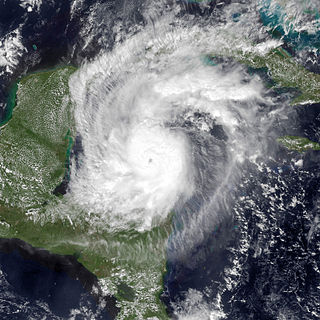
WHurricane Rina was a powerful and slow-moving tropical cyclone that caused minor impacts in the northwestern Caribbean Sea in late October 2011. The seventeenth named storm, seventh hurricane, and fourth major hurricane of the annual hurricane season, Rina developed from a tropical wave in the western Caribbean on October 23. The depression quickly intensified, and was upgraded to Tropical Storm Rina early on the following day. Further strengthening ensued as it tracked west-northwestward, with Rina becoming a hurricane on October 24. The hurricane eventually peaked as a Category 3 hurricane while it moved generally westward on October 25. However, on October 26, Rina weakened substantially and was downgraded to a Category 1 hurricane. Further weakening occurred, with Rina falling to tropical storm intensity on October 27. Rina then made landfall in northern Quintana Roo early the next day. The cyclone degenerated into a remnant low later on October 28 after emerging into the Yucatán Channel. The low dissipated near the western tip of Cuba on October 29.
 W
WTyphoon Roke, known in the Philippines as Tropical Storm Onyok, was a powerful and persistent tropical cyclone that affected Japan, including some areas that had been damaged by another typhoon just a few weeks prior. It was the fifteenth named storm, the tenth severe tropical storm, the sixth typhoon of the 2011 Pacific typhoon season and overall, the 27th tropical cyclone to be monitored by the Japan Meteorological Agency during the year.
 W
WTropical Storm Rolf, also known as Tropical Storm 01M and Invest 99L, was an unusual Mediterranean tropical storm that brought flooding to Italy, France, Spain, and Switzerland in November 2011. Rolf originated from an extratropical system near western France on 4 November. Despite the unfavorable conditions in the Mediterranean Sea, Rolf transitioned into a subtropical depression on 7 November, before becoming a fully tropical storm later that day. On 8 November, Rolf reached its peak intensity, with 1-minute sustained winds peaking at 80 km/h and a minimum central pressure of 991 mb (29.3 inHg). During the next day, the storm made landfall on the island of Île du Levant, France, and soon afterwards, near Hyères in Southeastern France. Following its second landfall, Rolf quickly weakened and dissipated on 10 November. Rolf was the first tropical cyclone ever to be officially monitored by the NOAA in the Mediterranean Sea. Rolf killed 12 people, and it was also the costliest Mediterranean tropical-like cyclone in the 2010s, with the storm causing at least $1.25 billion in damages.
 W
WSevere Tropical Storm Talas, was an unusually large tropical cyclone that caused many deaths and severe damage to Japan. It was the 12th named storm and the 7th severe tropical storm of the 2011 Pacific typhoon season. Talas is known to have killed at least 82 people, and 16 more are still missing. The word Talas is a Filipino word meaning sharpness. It followed five months after Japan was hit by a large tsunami.
 W
WVery Severe Cyclonic Storm Thane was the strongest tropical cyclone of 2011 within the Bay of Bengal. Thane initially developed as a tropical disturbance within the monsoon trough to the west of Indonesia. Over the next couple of days the disturbance gradually developed further while moving towards the northwest, and was declared a Depression during December 25, before being declared Cyclonic Storm Thane during the next day. As it was named, Thane started to turn towards the west under the influence of a subtropical ridge of high pressure before its development slowed during December 27, as a strong outflow and marginally favourable sea surface temperatures fought with persistent vertical wind shear. After its development had slowed during December 27, Thane became a Very Severe Cyclonic Storm during December 28, before as it approached the Indian states of Tamil Nadu, it weakened slightly. Thane then made landfall early on December 30, on the north Tamil Nadu coast between Cuddalore and Puducherry and rapidly weakened into a depression.
 W
WTropical Cyclone Vania was the third depression and first tropical cyclone of the 2010–11 South Pacific cyclone season.
 W
WSevere Tropical Storm Washi, known in the Philippines as Tropical Storm Sendong, was a late-season tropical cyclone that caused catastrophic damage in the Philippines in late 2011. Washi made landfall over Mindanao, a major region in the Philippines, on December 16. Washi weakened slightly after passing Mindanao, but regained strength in the Sulu Sea, and made landfall again over Palawan on December 17.
 W
WSevere Tropical Cyclone Wilma was a powerful tropical cyclone that affected the Samoan Islands, Tonga and New Zealand. Forming out of a trough of low pressure on 19 January 2011 to the northwest of Fiji, Cyclone Wilma initially tracked eastward towards the Samoan Islands. On 22 January, the system took a sharp southward turn, bringing its centre directly over American Samoa the following day. After turning towards the southwest and accelerating, Wilma steadily intensified into a severe tropical cyclone before striking Tonga. The storm reached its peak intensity on 26 January as a Category 4 cyclone with winds of 185 km/h (115 mph) and a barometric pressure of 930 mbar. Gradually re-curving towards the southeast, Wilma weakened quickly as it moved over cooler sea surface temperatures; by 28 January, it was downgraded to a tropical cyclone. Later that day, the storm brushed the North Island of New Zealand before transitioning into an extratropical cyclone.
 W
WSevere Tropical Cyclone Yasi was a powerful and destructive tropical cyclone that made landfall in northern Queensland, Australia in early 2011, causing major damage to the affected areas. Originating as a tropical low near Fiji on 26 January, the system intensified to tropical cyclone status during the evening of 30 January. Yasi deepened rapidly over the next 24 hours, and was classified as a Category 3 cyclone at about 5 PM AEST on 31 January 2011. Late on 1 February, the cyclone strengthened to a Category 4 system; then, early on 2 February, the cyclone intensified into a Category 5 Severe Tropical Cyclone. The system had a well-defined eye and continued to track west-southwestward, maintaining a central pressure of 930 hPa and a Dvorak intensity of T6.5 into the evening.