 W
WThe 1906 Hong Kong typhoon was a tropical cyclone that hit Hong Kong on 18 September 1906. The natural disaster caused property damage exceeding a million pounds sterling, affected international trade, and took the lives of around 15,000 people: about 5% of the then Hong Kong population.
 W
WThe 1937 Great Hong Kong Typhoon was an unnamed typhoon in Hong Kong on 2 September 1937. It was one of the deadliest typhoons in Hong Kong history killing 11,000 people. In Macau, 21 people died by this typhoon.
 W
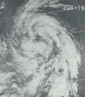
WTyphoon Bess, known in the Philippines as Typhoon Susang, was responsible for the disappearance of a United States Air Force weather reconnaissance aircraft. Developing out of a poorly organized system on October 8 to the east of the Philippines, Bess featured two centers of circulation. Initially the southern low was monitored; however, a low to the north soon became the dominant center. Tracking generally west-northwestward, the storm gradually intensified before striking northern Luzon as a minimal typhoon on October 11. Temporary weakening took place due to interaction with land. After moving back over water the following morning, Bess regained typhoon intensity. This was short-lived though, as conditions surrounding the cyclone soon caused it to weaken. Now moving due west, the weakening storm eventually struck Hainan Island as a tropical storm on October 12 before diminishing to a tropical depression. The depression briefly moved back over water before dissipating in northern Vietnam on October 14.
 W
WSevere Tropical Storm Brendan, also known in the Philippines as Tropical Storm Helming, was a third consecutive tropical cyclone to strike China in July 1991. A weak surface circulation developed near Carolina Islands in July 15. Tracking west-northwestward, the circulation organized into a tropical depression in July 19. The tropical depression intensified into Tropical Storm Brendan in July 21 when the depression approached Philippines. Brendan quickly intensified to reach the first peak intensity of 115 km/h (70 mph) when it made landfall in Luzon, Philippines. After emerging in Luzon Strait as a strong tropical storm and continued to track west-northwestward, Brendan reached the secondary peak intensity of 105 km/h (65 mph) in July 23, before making landfall on Guangdong, China, 30 kilometres (19 mi) southwest of Macau in July 24. After making landfall, Brendan weakened and dissipated later that day.
 W
WTyphoon Clara, known in the Philippines as Typhoon Rubing, left flooding in the northern Philippines and southern China during September 1981. An area of disturbed weather was first detected on September 11 near Ponape. After moving westward, the system gradually became better organized and thunderstorm activity increased. On September 16, the system attained tropical storm status. Two days later, Clara attained typhoon intensity and subsequently began to deepen at a faster rate. On September 19, Clara reached maximum intensity, before making landfall along the northern tip of Luzon. Clara steadily weakened after interacting with land, but by late on September 20, Clara leveled off in intensity over the South China Sea. The next day, Clara moved ashore to the east-northeast of Hong Kong while still at typhoon intensity before rapidly dissipating over land.
 W
WTyphoon Chanchu, known in the Philippines as Typhoon Caloy, was the most intense typhoon in the South China Sea in the month of May according to the Hong Kong Observatory (HKO). The first named storm of the 2006 Pacific typhoon season, Chanchu formed on May 8 in the vicinity of the Federated States of Micronesia and progressed westward. It gradually intensified into a tropical storm and later severe tropical storm before moving through the Philippines. On May 13, Chanchu entered the South China Sea and became a typhoon, according to the Japan Meteorological Agency (JMA). Warm waters and favorable outflow allowed the storm to quickly intensify to peak maximum sustained winds of 175 km/h (110 mph) on May 15. Around that time, the typhoon turned sharply to the north toward southeastern China. Chanchu weakened as it curved to the northeast, making landfall near Shantou, Guangdong on May 17 as a severe tropical storm. The government of China considered Chanchu the earliest typhoon to make landfall in the province. On the next day, the storm emerged into the East China Sea, becoming extratropical on May 19 before dissipating west of Kyushu.
 W
WTyphoon Chanthu, known as Tropical Storm Caloy, was one of the weaker typhoons of the 2010 Pacific typhoon season.
 W
WTyphoon Cimaron, known in the Philippines as Typhoon Paeng, was the most intense tropical cyclone to strike the Philippine island of Luzon since Typhoon Zeb in 1998. Originating from a tropical depression on October 25, Cimaron developed within an environment strongly favoring tropical cyclogenesis east of the Philippines. On October 28, the system underwent rapid intensification, culminating in attaining its peak strength with winds of 185 km/h (115 mph). Estimates from the Joint Typhoon Warning Center ranked the system as a Category 5-equivalent super typhoon with one-minute sustained winds of 260 km/h (160 mph), though this is argued to have underrepresented the typhoon's strength. The system moved ashore near Casiguran, Aurora in northern Luzon at peak strength. Crossing the island, Cimaron emerged over the South China Sea where conditions allowed for temporary reorganization. After becoming nearly stationary on November 1, the typhoon executed a tight anti-cyclonic loop and rapidly weakened. The storm degenerated into a tropical depression on November 4, before dissipating three days later off the coast of Vietnam.
 W
WTyphoon Dot was a strong tropical cyclone that made landfalls on Luzon and near Hong Kong in October 1964. It was the fifth typhoon to impact Hong Kong during the active 1964 Pacific typhoon season, and prompted the issuance of the No. 10 typhoon signal from the Royal Observatory in Hong Kong—the highest warning possible. The storm's precursor disturbance formed west of Pohnpei on October 3 and tracked towards the west, becoming a tropical storm by October 6. Gradually strengthening, Dot moved towards the west-northwest, northwest, and then curved west, leading to a landfall at typhoon intensity on Luzon on October 9. A freighter with 32 crewmembers went missing west of the island after passing through the typhoon and was never recovered.
 W
WTyphoon Dot, known in the Philippines as Typhoon Kuring, was one of several tropical cyclones to impact southern China and northern Vietnam during the 1989 Pacific typhoon season. Originating from a tropical disturbance near Palau on June 4, Dot tracked west-northwestward towards the Philippines. Crossing the country on June 6, the system moved over the South China Sea and attained typhoon status. Late on June 8, Dot reached its peak intensity with winds estimated at 185 km/h (115 mph). The system weakened slightly the next day before making landfall in Hainan Island. A weakened storm then entered the Gulf of Tonkin before striking northern Vietnam and dissipating on June 12.
 W
WTyphoon Elsie, known in the Philippines as Typhoon Tasing, was one of the most intense known tropical cyclones to make landfall in the Philippines. A powerful Category 5 super typhoon, Elsie formed out of a tropical disturbance on October 13, 1989, and initially moved relatively slowly in an area of weak steering currents. On October 15, the storm underwent a period of rapid intensification, attaining an intensity that corresponds to a Category 3 hurricane on the Saffir–Simpson Hurricane Scale. After taking a due west track towards the northern Philippines, the storm intensified further, becoming a Category 5 super typhoon hours before making landfall in Luzon. After moving inland, the typhoon rapidly weakened to a tropical storm. Once back over water in the South China Sea, wind shear prevented re-intensifcation. Elsie eventually made landfall in Vietnam on October 22 and dissipated the following day over Laos.
 W
WTyphoon Fengshen, known in the Philippines as Typhoon Frank, was the sixth named storm and the fourth typhoon recognised by the Japan Meteorological Agency. The Joint Typhoon Warning Center recognised Fengshen as the seventh tropical depression, the sixth tropical storm, and fifth typhoon of the 2008 Pacific typhoon season.
 W
WSuper Typhoon Gordon, known in the Philippines as Typhoon Goring, was a powerful tropical cyclone that caused widespread damage and loss of life in the Philippines and Southern China in July 1989. Originating from a single cumulonimbus cloud on July 9, Gordon developed into a tropical depression near the Northern Mariana Islands and quickly intensified as it tracked west-southwestward. On July 13, the storm attained typhoon status and subsequently underwent a period of rapid intensification. By July 15, the storm attained its peak strength as a Category 5 equivalent super typhoon with winds estimated at 260 km/h (160 mph). After striking the northern Philippines, Gordon moved through the South China Sea and slowly weakened. On July 18, the storm made landfall in southern China and was last noted the following day as it dissipated over land.
 W
WTyphoon Hagupit, known in the Philippines as Typhoon Nina, was a powerful cyclone that caused widespread destruction along its path in September 2008. The 21st depression, 14 tropical storm and 10th typhoon of the 2008 Pacific typhoon season, Hagupit developed from a tropical wave located a couple hundred miles east of the Marshall Islands on September 14th. Moving generally north-west westwards towards the Philippines, the depression gradually intensified into a tropical storm the following day, and then into became a typhoon on September 22 off the northern coast of Luzon. Located within an environment conducive for strengthening, Hagupit rapidly strengthened to attain 10-min sustained winds of 165 km/h and 1-min sustained winds of 230 km/h. After making landfall in Guangdong province in China at peak intensity on September 23, Hagupit rapidly weakened over rugged terrain and dissipated on the 25th.
 W
WTyphoon Haiyan, known in the Philippines as Super Typhoon Yolanda, was one of the most powerful tropical cyclones ever recorded. On making landfall, Haiyan devastated portions of Southeast Asia, particularly the Philippines. It is one of the deadliest Philippine typhoons on record, killing at least 6,300 people in that country alone. In terms of JTWC-estimated 1-minute sustained winds, Haiyan is tied with Meranti in 2016 for being the second strongest landfalling tropical cyclone on record. In January 2014, bodies were still being found.
 W
WTropical Storm Pakhar, known in the Philippines as Tropical Storm Jolina, was a strong tropical storm that impacted South China during late August 2017. This storm followed Typhoon Hato which affected the area a few days prior. Pakhar was the fourteenth named storm of the Pacific typhoon season. Pakhar developed from a tropical depression to the east of Luzon during August 24, and intensified into a tropical storm later that day. Pakhar made landfall over in Aurora on August 25. Pakhar gradually intensified and peaked as a severe tropical storm by August 27, making landfall over Taishan, Jiangmen in Southern China.
 W
WTyphoon Hato, known in the Philippines as Tropical Storm Isang, was a strong tropical cyclone that struck South China in August 2017. Developing as the thirteenth named storm and the fourth typhoon of the Pacific typhoon season, Hato formed as a tropical depression over the east of Luzon on 19 August. The system further developed and became a tropical storm the next day. On 21 August, Hato emerged over the northern portion of the South China Sea and reached typhoon intensity. Rapid intensification ensued on 23 August, and Hato became a Category 3-equivalent typhoon before making landfall over Jinwan, Zhuhai. The storm further weakened over land and dissipated on 24 August.
 W
WTropical Storm Higos, known in the Philippines as Tropical Storm Pablo, was a tropical storm during the 2008 Pacific typhoon season. The name "Higos" is the Chamorro word for fig.
 W
WSuper Typhoon Hope, known in the Philippines as Typhoon Ising, was a powerful Category 4 typhoon that killed over 100 people when it struck Hong Kong in 1979. The fifth typhoon and first super typhoon of the 1979 Pacific typhoon season, it formed as a tropical depression southeast of Guam on July 24. It headed to the west-northwest, but upper-level shear from the TUTT caused the depression to dissipate on the 27th. It turned northward then westward, where it regenerated on the 28th. Intensification became more steady, with the depression reaching storm strength on the 28th and typhoon strength on the 29th. On the 31st, Hope reached a peak of 150 mph winds, but land interaction with Taiwan to the north weakened the storm.
 W
WTyphoon Joe, known in the Philippines as Typhoon Nitang, affected the Philippines, China, and Vietnam during July 1980. An area of disturbed weather formed near the Caroline Islands on July 14. Shower activity gradually became better organized, and two days later, the system was upgraded into a tropical depression. On July 18, the depression was classified as Tropical Storm Joe. Initially, Joe moved northwest, but began to turn to the west-northwest, anchored by a subtropical ridge to its north. Joe started to deepen at a faster clip, and attained typhoon intensity on July 19. The eye began to clear out, and the next day, Joe reached its highest intensity. Shortly thereafter, Joe moved ashore the Philippines. There, 31 people were killed and 300,000 others were directly affected. Around 5,000 homes were destroyed, resulting in an additional 29,000 homeless. Damage in the nation was estimated at $14.5 million (1980 USD).
 W
WTyphoon Kim, known in the Philippines as Typhoon Osang, was the second typhoon in a week to directly affect the Philippines during July 1980. Like Typhoon Joe, Kim formed from the near equatorial monsoon trough in the northwestern Pacific Ocean on July 19. The disturbance tracked quickly westward-northwest underneath a subtropical ridge, reaching tropical storm strength on the July 21 and typhoon strength on July 23. After developing an eye, Kim began to rapidly intensify, and during the afternoon of July 24, peaked in intensity as a super typhoon. Several hours later, Kim made landfall over the Philippines, but the storm had weakened considerably by this time. Throughout the Philippines, 40 people were killed, 2 via drownings, and 19,000 others were directly affected. A total of 12,000 homes were destroyed and 5,000 villages were flooded. Less than a week earlier, the same areas were affected by Joe; however, Kim was considered the more damaging of the two typhoons. Land interaction took its toll on Kim, and upon entering the South China Sea, the storm was down below typhoon intensity. Kim continued northwestward but its disrupted circulation prevented re-intensification, and it remained a tropical storm until hitting southern China July 27 to the northeast of Hong Kong, where only slight damage was reported. Later that day, Kim dissipated.
 W
WTyphoon Kai-tak, known in the Philippines as Tropical Storm Helen, was a mild tropical cyclone that affected China, Vietnam and Laos. It was the seventh typhoon and the thirteenth named storm of the 2012 Pacific typhoon season. The storm killed 41 people and caused a sum of US$765 million in losses. Kai-tak can be tracked back to the broad area of disturbance embedded in a monsoonal trough that was first spotted, early on August 10. It was only at midnight, on August 16, when the JMA officially declared Kai-tak a typhoon. On the morning of August 17, the windspeed dropped to 60 knots and was no longer a typhoon. The typhoon caused heavy damage in China's two provinces killing four people and causing huge economic loss. Kai-Tak slammed the northern Philippines triggering flash floods and landslides and killing at least ten people, one week after deadly monsoon rains battered the country. In Vietnam, Kai-Tak has stormed across the country's north bringing high winds and floods to several areas including the capital Hanoi.
 W
WSevere Tropical Storm Kammuri, known in the Philippines as Tropical Storm Lagalag, killed hundreds of people in the wake of a deadly flood season in China. The system developed from a large monsoonal system that persisted toward the end of July 2002 near the Philippines. On August 2, a tropical depression formed off the northwest coast of Luzon and moved west-northwestward. Late on August 3, it intensified into Tropical Storm Kammuri off the coast of Hong Kong. A weakening ridge turned the storm northward toward the coast of China. The storm made landfall with late on August 4, after reaching peak winds of 100 km/h (65 mph). The system dissipated over the mountainous coastline of eastern China and merged with a cold front on August 7.
 W
WSevere Tropical Storm Kammuri, known in the Philippines as Tropical Storm Julian, was a storm which made landfall on south China in August 2008, having a maximum wind speed of 50 kn (93 km/h). The name Kammuri was submitted to the World Meteorological Organisation's Typhoon Committee by Japan and is Japanese for the Corona Borealis constellation of stars.
 W
WSuper Typhoon Koryn, known in the Philippines as Typhoon Goring, was the third named storm, first typhoon and super typhoon of the 1993 Pacific typhoon season. Koryn formed on June 13 and reached super typhoon status on June 26 with winds at 150 mph (240 km/h) and a barometric pressure of 910 millibars. A powerful super typhoon, Koryn caused serious damage across the Caroline Islands, Philippines, and People's Republic of China, leaving 37 people dead and $14 million.
 W
WLi's Field is a tongue-in-cheek conspiracy theory in Hong Kong over the existence of a force field that repels tropical cyclones from the city.
 W
WSevere Tropical Storm Linfa was the second named storm to develop in the South China Sea during the 2009 Pacific typhoon season. It is the seventh depression and third typhoon of the season. Forming out of an area of low pressure on June 14, the storm briefly attained tropical depression status before degenerating. By June 17 the system regenerated in the South China Sea. Slowly tracking northward, the storm intensified, attaining severe tropical storm status on June 19 and peaking in intensity the following day. On June 21, Linfa made landfall in Fujian Province, China as a tropical storm before weakening to a tropical depression.
 W
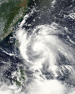
WTyphoon Mangkhut, known in the Philippines as Typhoon Ompong, was an extremely powerful and catastrophic tropical cyclone that caused extensive damage in Guam, the Philippines and South China in September 2018. It was the strongest typhoon to strike Luzon since Megi in 2010, and the strongest to make landfall anywhere in the Philippines since Haiyan in 2013. Mangkhut was also the strongest typhoon to affect Hong Kong since Ellen in 1983.
 W
WTyphoon Mary, also nicknamed "Bloody Mary" by the Joint Typhoon Warning Center (JTWC), was an extremely damaging storm that was part of the 1960 Pacific typhoon season. It began as a circulation in a trough in the South China Sea. A tropical depression formed on June 2, as it was traveling clockwise. It became a tropical storm on the next day, and received the name Mary. It slowly moved across the sea, strengthening to a typhoon. Mary made landfall in Hong Kong on June 8, and moved through Guangdong and Fujian. It reemerged back to the Pacific Ocean, and restrengthened into a typhoon temporarily. It then traveled east, weakening and becoming extratropical on June 12.
 W
WTyphoon Neoguri, known in the Philippines as Typhoon Ambo, was the earliest tropical cyclone on record to strike China. The first named storm in the 2008 Pacific typhoon season, named after the Korean word for raccoon dog, it formed from a low pressure area on April 13 to the east of the Philippine island of Mindanao, and after crossing the island it intensified into a tropical storm in the South China Sea. Environmental conditions allowed for quick strengthening, with Neoguri attaining typhoon status on April 16. The typhoon reached its peak intensity on April 18 as it approached the island of Hainan, and subsequently it turned northward. Due to increased wind shear and cooler waters, Neoguri rapidly weakened and made landfall as a minimal tropical storm in southern China on April 19.
 W
WTyphoon Nesat, known in the Philippines as Typhoon Pedring, was the most powerful tropical cyclone to directly impact China since 2005. It also struck the Philippines during the 2011 Pacific typhoon season, killing 83 people. It is the 17th named storm, the 11th severe tropical storm, the 7th typhoon and overall, the 30th tropical cyclone to be monitored by the Japan Meteorological Agency(JMA) during the year. Nesat came exactly two years after Typhoon Ketsana made landfall in the Philippines as the most devastating typhoon in the 2009 Pacific typhoon season with a damage of US$1.09 billion and 747 fatalities. Nesat was also the first of twin tropical cyclones to batter the Philippines within one week during September 2011, the second was Nalgae.
 W
WSevere Tropical Storm Nock-ten, known in the Philippines as Tropical Storm Juaning, was a strong tropical storm which made a total of four landfalls in Southeast Asia, killing more than 100 people and causing damage estimated at US$126 million. It was the eighth named storm and the fourth severe tropical storm of the 2011 Pacific typhoon season.
 W
WTyphoon Nora, known in the Philippines as Typhoon Luming, was the fourth-most intense tropical cyclone on record. Originating from an area of low pressure over the western Pacific, Nora was first identified as a tropical depression on October 2, 1973. Tracking generally westward, the system gradually intensified, attaining typhoon status the following evening. After turning northwestward, the typhoon underwent a period of rapid intensification, during which its central pressure decreased by 77 mb in 24 hours. At the end of this phase, Nora peaked with winds of 295 km/h (185 mph) and a pressure of 877 mb, making it the most-intense tropical cyclone on record at the time; however, this pressure has since been surpassed by three other typhoons and one hurricane. The typhoon subsequently weakened and turned northwestward as it approached the Philippines. After brushing Luzon on October 7, the system passed south of Taiwan and ultimately made landfall in China on October 10. Once onshore, Nora quickly weakened and dissipated the following day.
 W
WTyphoon Nuri, known in the Philippines as Typhoon Karen, was the 12th named storm and the seventh typhoon that was recognised by the Japan Meteorological Agency. The Joint Typhoon Warning Center recognised it as the 13th tropical depression, the 12th tropical storm and the 8th typhoon of the 2008 Pacific typhoon season. The name Nuri was submitted to the World Meteorological Organisation's Typhoon Committee by Malaysia in 2003 after the name Rusa was retired in 2002. The name Nuri is Malay for a blue crowned parroquet, a type of parrot. The name Karen was assigned by PAGASA to a tropical depression for the second time, the other time being in 2004 to Typhoon Rananim.
 W
WTyphoon Percy, known in the Philippines as Typhoon Klaring, was the third tropical cyclone to affect the country in 1990. The fourth and the last tropical cyclone to be formed in June of the 1990 Pacific typhoon season, Typhoon Percy originated from an area of disturbed weather spawned by the Western Pacific monsoon trough on June 20. That same day, the disturbance was classified as a tropical depression as it slowly organized and on June 21, the depression obtained tropical storm intensity. After initially tracking westward, Percy turned towards the southwest while slowly deepening. During this time, Percy affected several of the Carolina Islands. Thirty homes were damaged and airline services were halted in and out of Yap. Farther south-southwest, seven homes were destroyed on the Ngulu Atoll. Furthermore, one boy was killed on Koror, where numerous homes lost their roofs and communication lines were downed. Percy then turned back to the west-northwest and became a typhoon on June 23. It then began to deepen at a faster rate, with Percy attaining its maximum intensity of 145 km/h (90 mph) on June 25. Two days later, on June 27, increased wind shear began to induce a weakening trend and the typhoon brushed Luzon, where eight people were killed and over 30,000 lost their homes. Despite that however, damages in the country was minor.
 W
WTyphoon Pabuk, known in the Philippines as Tropical Storm Chedeng, was a minimal typhoon that formed during the day of August 5, 2007. The system made landfall on Taiwan on August 7, and on August 9 Pabuk passed to the south of Hong Kong.
 W
WTyphoon Prapiroon, known in the Philippines as Tropical Storm Henry, was a minimal typhoon which caused deadly flooding in southern China in August 2006. Prapiroon developed out of a persistent area of convection accompanied by an area of low pressure on July 25 about 120 km (75 mi) west-southwest of Yap. Two days later, both the Japan Meteorological Agency (JMA) and PAGASA classified the system as a tropical depression, with PAGASA giving it the local name 'Henry'. By July 31, the Joint Typhoon Warning Center (JTWC) classified the system as Tropical Depression 07W. A strong subtropical ridge located to the north of the depression led to a west-northwest movement for most of the storm existence.
 W
WTyphoon Rammasun, known in the Philippines as Typhoon Glenda, was one of the only two Category 5 super typhoons on record in the South China Sea, with the other one being Pamela in 1954. Rammasun had destructive impacts across the Philippines, South China, and Vietnam in July 2014. Rammasun is a Siamese word for thunder god. After Lingling and Kajiki earlier in 2014, Rammasun became the third tropical cyclone, and first typhoon to directly impact the Philippines in 2014. The ninth named storm and the third typhoon of the annual typhoon season, Rammasun formed in the Intertropical Convergence Zone, an area near the equator where the northeast and southeast trade winds come together, and slowly drifted northwest. Having passed through the islands of Micronesia, the system turned west and quickly moved under the influence of a subtropical ridge (STR). Rammasun posed a significant threat to the Philippine island of Luzon, as it was expected to reach typhoon intensity before making landfall there. Though initially forecast to make landfall in Cagayan Valley, the storm followed a more westerly path and was later forecast to make landfall in the Bicol Region and then pass through Bataan and Zambales before brushing past Metro Manila.
 W
WTyphoon Rose, known in the Philippines as Typhoon Uring, was the most violent and intense tropical cyclone to strike Hong Kong since Typhoon Wanda in 1962. The 21st named storm of the 1971 Pacific typhoon season, Rose developed from an area of disturbed weather while west of Guam on August 9. Moving west-northwestward, the storm briefly became a typhoon on the following day. After weakening to a tropical storm on August 11, Rose re-intensified into a typhoon several hours later. The system then curved westward and reached a primary peak intensity with winds of 205 km/h (125 mph) on August 13. Later that day, the typhoon made landfall near Palanan, Isabela in the Philippines. Rose weakened significantly while crossing the island of Luzon and was a minimal typhoon upon reaching the South China Sea on August 14.
 W
WTyphoon Ruby, known in the Philippines as Typhoon Yoning, was a strong tropical cyclone that struck Hong Kong, Macau, and southern China in early September 1964. The precursor disturbance to Ruby was first identified on August 29 over the Philippine Sea, and this system organised into a tropical cyclone by September 1. Ruby intensified as it moved west, becoming a typhoon the next day and subsequently passing over the Babuyan Islands of the Philippines. After reaching the South China Sea, Ruby turned northwest and intensified further, attaining peak ten-minute sustained winds of 195 km/h (120 mph) before making landfall at the peak intensity near Hong Kong on September 5. The typhoon weakened after moving inland and dissipated on September 6 over southeastern China.
 W
WSevere Tropical Storm Rumbia, known in the Philippines as Tropical Storm Gorio, was a tropical cyclone that brought widespread flooding in areas of the Philippines and China late June and early July 2013. The sixth internationally named storm of the season, Rumbia formed from a broad area of low pressure situated in the southern Philippine Sea on June 27. Steadily organizing, the initial tropical depression moved towards the northwest as the result of a nearby subtropical ridge. On June 28, the disturbance strengthened to tropical storm strength, and subsequently made its first landfall on Eastern Samar in the Philippines early the following day. Rumbia spent roughly a day moving across the archipelago before emerging into the South China Sea. Over open waters, Rumbia resumed strengthening, and reached its peak intensity with winds of 95 km/h (50 mph) on July 1, ranking it as a severe tropical storm. The tropical cyclone weakened slightly before moving ashore the Leizhou Peninsula late that day. Due to land interaction, Rumbia quickly weakened into a low pressure area on July 2 and eventually dissipated soon afterwards.
 W
WTyphoon Sally was a powerful tropical cyclone that brought widespread impacts during its week-long trek across the western Pacific in September 1964. It was the most intense typhoon of the 1964 Pacific typhoon season and among the strongest typhoons ever recorded, with one-minute maximum sustained winds of 315 km/h (195 mph) as estimated by the Joint Typhoon Warning Center. Sally first became a tropical cyclone near the Marshall Islands on September 3, organizing into a tropical depression and then a tropical storm later that day. On September 4, Sally intensified into a typhoon and struck southern Guam the next day. Widespread agricultural damage occurred in the island's southern regions, with the banana crop suffering the costliest losses; the damage toll from crops and property exceeded $115,000. Sally continued to intensify on its west-northwestward trek, and reached its peak strength on September 7 over the Philippine Sea.
 W
WSevere Tropical Storm Sam, also known in the Philippines as Luding was a storm that formed on August 1999.
 W
WTyphoon Zeke, known in the Philippines as Typhoon Etang, was the first of two typhoons to make landfall in China within a week during mid-July 1991. An area of disturbed weather developed east of the Philippines towards the end of the first week of July. Tracking west-northwestward, the disturbance organized into a tropical depression on July 9. After tracking across the Philippines, where it left two people missing and injured three others, the depression intensified into a tropical storm on July 10. The storm steadily deepened as it moved across the South China Sea, and on July 12 it strengthened into a typhoon. While at its peak intensity of 120 km/h (75 mph), Zeke moved moved onshore Hainan, where it began to weaken. The system tracked across Vietnam on July 13, and dissipated within two days after moving inland.
 W
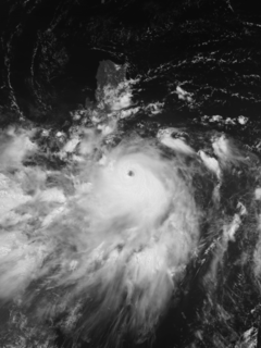
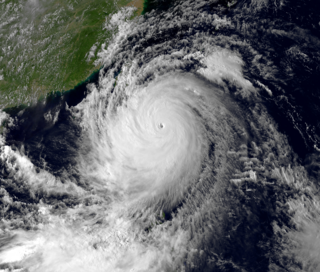
WTyphoon Usagi, known in the Philippines as Typhoon Odette, was a violent tropical cyclone which affected Taiwan, the Philippines, China, and Hong Kong in September 2013. Usagi , or which means the constellation Lepus in Japanese, was the fourth typhoon and the nineteenth tropical storm in the basin. Developing into a tropical storm east of the Philippines late on September 16, Usagi began explosive intensification on September 19 and ultimately became a violent and large typhoon. Afterwards, the system weakened slowly, crossed the Bashi Channel on September 21, and made landfall over Guangdong, China on September 22.
 W
WTyphoon Utor, known in the Philippines as Typhoon Labuyo, was the 15th depression and the 2nd typhoon in the 2013 typhoon season.
 W
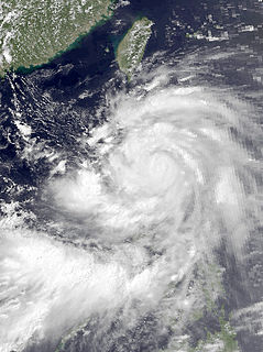
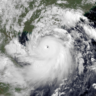
WTyphoon Vicente, known in the Philippines as Tropical Depression Ferdie, was the strongest tropical cyclone to strike the Chinese province of Guangdong since Hagupit in 2008, and was regarded as the strongest storm to affect Hong Kong and Macau in more than ten years. The eighth named storm and third typhoon in the 2012 Pacific typhoon season, Vicente began life as a tropical depression on July 18, 2012 north east of the Philippines. Vicente soon steadily moved into the South China Sea, and began to intensify above warm sea waters, and began explosive intensification early on July 23, and started to charge toward the Guangdong region prompting the Hong Kong Observatory (HKO) to issue the Hurricane Signal, No. 10, the first since York in 1999. The Macao Meteorological and Geophysical Bureau also hoisted the Signal No. 9 for the first time since York and after the transfer of sovereignty over Macau. Late on the same day, Vicente made landfall over Taishan in Guangdong, China.
 W
WTyphoon Wanda was one of the most intense tropical cyclones on record in Hong Kong. It was the 59th disturbance in the record-breaking 1962 Pacific typhoon season, forming in August east of the Philippines. Typhoon Wanda reached peak winds of 175 km/h (110 mph) in the South China Sea, and it made landfall on Hong Kong on September 1, producing gusts of 261 km/h (161 mph) which, in combination with a high storm surge, damaged thousands of huts and left 72,000 people homeless. Wanda left a total of 434 deaths, and it is estimated that an identical typhoon striking today would cause HK$2.6 billion in losses.
 W
WTyphoon Wayne, known in the Philippines as Typhoon Miding, is one of the longest-lived tropical cyclones on record in the north-western Pacific Ocean. The system meandered for 21 days in August–September 1986 between the South China Sea and far western tropical North Pacific Ocean, staying within the monsoon trough and causing heavy rains across the Philippines, Taiwan, southeast China, Hainan Island, and Vietnam. Its maximum sustained winds peaked at category two strength on the Saffir–Simpson scale. Various signals were raised for Hong Kong three times due to Wayne's unusual track. A total of 490 perished, and the storm caused US $399 million in damage.