 W
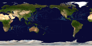
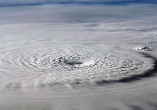
WDuring 2012, tropical cyclones formed within seven different tropical cyclone basins, located within various parts of the Atlantic, Pacific and Indian Oceans. During the year, a total of 128 tropical cyclones had formed this year to date. 88 tropical cyclones had been named by either a Regional Specialized Meteorological Center (RSMC) or a Tropical Cyclone Warning Center (TCWC).
 W
WThe 2012 Atlantic hurricane season was the final year in a consecutive string of three very active seasons, although many of the storms were weak and short-lived. It is tied with 1887, 1995, 2010, and 2011 for the fourth-most active Atlantic hurricane season on record, with 19 tropical storms. It was also the third-costliest season, behind 2005 and 2017. The season officially began on June 1 and ended on November 30, dates that conventionally delimit the period during each year in which most tropical cyclones form in the Atlantic Ocean. However, Alberto, the first system of the year, developed on May 19 – the earliest date of formation since Tropical Storm Ana in 2003. A second tropical cyclone, Beryl, developed later that month. This was the first occurrence of two pre-season named storms in the Atlantic basin since 1951. It moved ashore in North Florida on May 29 with winds of 65 mph (105 km/h), making it the strongest pre-season storm to make landfall in the Atlantic basin. This season marked the first time since 2009 where no tropical cyclones formed in July. Another record was set by Hurricane Nadine later in the season; the system became the fourth-longest-lived tropical cyclone ever recorded in the Atlantic, with a total duration of 22.25 days. The final storm to form, Tony, dissipated on October 25 – however, Hurricane Sandy, which formed before Tony, became extratropical on October 29.
WThe 2012 Atlantic hurricane season was an event in the annual hurricane season in the north Atlantic Ocean. It featured the third-most named storms for the third consecutive year on record. The season officially began on June 1, 2012, and ended on November 30, 2012, dates that conventionally delimit the period of each year when most tropical cyclones develop in the Atlantic basin. Surprisingly, two preseason storms formed: Alberto on May 19, and Beryl on May 26. This was the first such occurrence since the 1908 season. The final storm to dissipate was Sandy, on October 29. Altogether, there were 19 named storms during the season, including ten hurricanes of which two intensified into major hurricanes.
 W
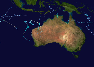
WThe 2011–12 Australian region cyclone season was a below average tropical cyclone season, with 7 cyclones forming rather than the usual 11. It began on 1 November 2011, and ended on 14 May 2012. The regional tropical cyclone operational plan defines a "tropical cyclone year" separately from a "tropical cyclone season"; the "tropical cyclone year" began on 1 July 2011 and ended on 30 June 2012.
 W
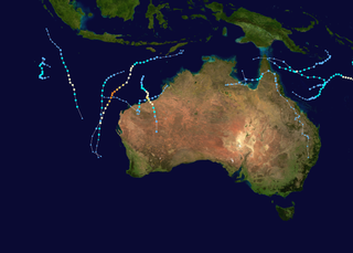
WThe 2012–13 Australian region cyclone season was a slightly below average tropical cyclone season event in the ongoing cycle of tropical cyclone formation. It officially started on 1 November 2012, and officially ended on 30 April 2013, despite Cyclone Zane being an active system at the time. The regional tropical cyclone operational plan defines a "tropical cyclone year" separately from a "tropical cyclone season"; the "tropical cyclone year" began on 1 July 2012 and ended on 30 June 2013.
 W
WThe 2012 Pacific hurricane season was a moderately active Pacific hurricane season that saw an unusually high number of tropical cyclones pass west of the Baja California Peninsula. The season officially started on May 15 in the eastern Pacific, and on June 1 in the central Pacific, and ended on November 30; these dates conventionally delimit the period during which most tropical cyclones form in the northeastern Pacific Ocean. However, with the formation of Tropical Storm Aletta on May 14 the season slightly exceeded these bounds.
WThe 2012 Pacific hurricane season was an above-average year in which seventeen named storms formed. The hurricane season officially began on May 15 with the formation of Tropical Storm Aletta in the East Pacific—defined as the region east of 140°W—and on June 1 in the central Pacific—defined as the region west of 140°W to the International Date Line—and ended on November 30 in both basins. These dates conventionally delimit the period during each year when most tropical cyclones form. The final cyclone of the year, Tropical Storm Rosa, dissipated on November 3.
 W
WThe 2012 North Indian Ocean cyclone season was an event in the annual cycle of tropical cyclone formation. The season had a late start, with the first system forming in October. During the season, only five systems formed, of which only two became cyclonic storms. Both the storms made landfall, and they, along with the deep depressions, were responsible for 128 deaths and economic losses worth at least $56.7 million.
WThe 2012 North Indian Ocean cyclone season is an ongoing event in the annual cycle of tropical cyclone formation. The scope of this article is limited to the Indian Ocean in the Northern Hemisphere, east of the Horn of Africa and west of the Malay Peninsula. There are two main seas in the North Indian Ocean — the Arabian Sea to the west of the Indian subcontinent, abbreviated ARB by the India Meteorological Department (IMD); and the Bay of Bengal to the east, abbreviated BOB by the IMD. The official Regional Specialized Meteorological Centre in this basin is the India Meteorological Department (IMD), while the Joint Typhoon Warning Center releases unofficial advisories. This timeline includes information that was operationally released, meaning that data from post-storm reviews by the IMD, such as a storm that was not operationally warned upon, has not been included. This timeline documents tropical cyclone formations, strengthening, weakening, landfalls, and dissipations during the season.
 W
WThe 2011–12 South Pacific cyclone season was one of the least active South Pacific tropical cyclone seasons on record, with only three tropical cyclones occurring during the season. The season ran from November 1, 2011 to April 30, 2012, however, any tropical cyclones that form before June 30, 2012 would have fallen within the 2011–12 tropical cyclone year and would have counted towards the season total. The strongest and only severe tropical cyclone that occurred during the season was Severe Tropical Cyclone Jasmine, which tracked in from out of the South Pacific basin. Within the basin, tropical cyclones are monitored by the Regional Specialized Meteorological Center (RSMC) in Nadi, Fiji, and the Tropical Cyclone Warning Center (TCWC) in Wellington, New Zealand. RSMC Nadi attaches an F designation to tropical disturbances that form in or move into the South Pacific. The United States Joint Typhoon Warning Center (JTWC) issues unofficial warnings within the South Pacific, designating tropical storm-equivalent or greater tropical cyclones with a number and a P suffix. RSMC Nadi and TCWC Wellington both use the Australian Tropical Cyclone Intensity Scale, and measure windspeeds over a period of ten minutes, while the JTWC measures sustained winds over a period of one minute and uses the Saffir–Simpson Hurricane Scale.
 W
WThe 2012–13 South Pacific cyclone season was a below average tropical cyclone season, with five tropical cyclones occurring within the basin between 160°E and 120°W. The season officially ran from November 1, 2012 to April 30, 2013, however the last tropical disturbance was last noted on May 1, as it moved into the subtropics. During the season, tropical cyclones were officially monitored by the Fiji Meteorological Service (FMS), Australian Bureau of Meteorology (BoM) and New Zealand's MetService. The United States Joint Typhoon Warning Center (JTWC) and other national meteorological services including Météo-France and NOAA also monitored the basin during the season. During the season there were 22 significant tropical disturbances assigned a number and a F suffix by the FMS's Regional Specialized Meteorological Center in Nadi, Fiji (RSMC Nadi), including Severe Tropical Cyclone Sandra which moved into the basin from the Australian region on March 9. The BoM, MetService and RSMC Nadi all estimated sustained wind speeds over a period of 10-minutes and used the Australian tropical cyclone intensity scale, while the JTWC estimated sustained winds over a 1-minute period, which are subsequently compared to the Saffir–Simpson hurricane wind scale (SSHS).
 W
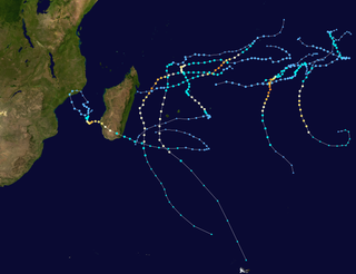
WThe 2011–12 South-West Indian Ocean cyclone season was a slightly above average event in tropical cyclone formation. It began on November 15, 2011, and ended on April 30, 2012, with the exception for Mauritius and the Seychelles, for which it ended on May 15, 2012. These dates conventionally delimit the period of each year when most tropical cyclones form in the region; however, Severe Tropical Storm Kuena developed in early June after the season had officially ended. The basin is defined as the area west of 90°E and south of the Equator in the Indian Ocean, which includes the waters around Madagascar westward to the east coast of Africa. Tropical cyclones in this basin are monitored by the Regional Specialised Meteorological Centre in Réunion.
 W
WThe 2012–13 South-West Indian Ocean cyclone season was a slightly above average event in tropical cyclone formation in the Southern hemisphere tropical cyclone year starting on July 1, 2012, and ending on June 30, 2013. Within this basin, tropical and subtropical disturbances are officially monitored by the Regional Specialised Meteorological Centre on Réunion island, while the Mauritius and Madagascar weather services assign names to significant tropical and subtropical disturbances. The first tropical disturbance of the season developed on October 12 and rapidly developed into the earliest known intense tropical cyclone on record during October 14.
 W
WThe 2012 Pacific typhoon season was a slightly below average but destructive season, though rather active since 2004. It produced 25 named storms, fourteen typhoons, and four intense typhoons. It was an event in the annual cycle of tropical cyclone formation, in which tropical cyclones form in the western Pacific Ocean. The season ran throughout 2012, though most tropical cyclones typically develop between May and October. The season's first named storm, Pakhar, developed on March 28, while the season's last named storm, Wukong, dissipated on December 29. The season's first typhoon, Guchol, reached typhoon status on June 15, and became the first super typhoon of the year on June 17.
WThis timeline documents all of the events of the 2012 Pacific typhoon season, the period that tropical cyclones formed in the Western Pacific Ocean during 2012. Most of these tropical cyclones formed between May and November 2012. The scope of this article is limited to the Pacific Ocean, north of the equator between 100°E and the International Date Line. Tropical storms that form in the entire Western Pacific basin are assigned a name by the Japan Meteorological Agency (JMA). Tropical depressions that form in this basin are given a number with a "W" suffix by the United States' Joint Typhoon Warning Center (JTWC). In addition, the Philippine Atmospheric, Geophysical and Astronomical Services Administration (PAGASA) assigns names to tropical cyclones that enter or form in the Philippine area of responsibility. These names, however, are not in common use outside of the Philippines.
 W
WTropical Storm Beryl was the strongest off-season Atlantic tropical cyclone on record to make landfall in the United States. The second tropical cyclone of the 2012 Atlantic hurricane season, Beryl developed on May 26 from a low-pressure system offshore North Carolina. Initially subtropical, the storm slowly acquired tropical characteristics as it tracked across warmer sea surface temperatures and within an environment of decreasing vertical wind shear. Late on May 27, Beryl transitioned into a tropical cyclone less than 120 miles (190 km) from North Florida. Early the following day, the storm moved ashore near Jacksonville Beach, Florida, with peak winds of 65 mph (100 km/h). It quickly weakened to a tropical depression, dropping heavy rainfall while moving slowly across the southeastern United States. A cold front turned Beryl to the northeast, and the storm became extratropical on May 30.
 W
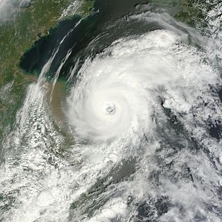
WTyphoon Bolaven, known in the Philippines as Typhoon Julian, was regarded as the most powerful storm to strike the Korean Peninsula in nearly a decade, with wind gusts measured up to 186 km/h (116 mph). Forming as a tropical depression on August 19, 2012 to the southwest of the Mariana Islands, Bolaven steadily intensified as it slowly moved west-northwestward in a region favoring tropical development. The system was soon upgraded to a tropical storm less than a day after formation and further to a typhoon by August 21. Strengthening became more gradual thereafter as Bolaven grew in size. On August 24, the system attained its peak intensity with winds of 185 km/h (115 mph) and a barometric pressure of 910 mbar. Weakening only slightly, the storm passed directly over Okinawa on August 26 as it began accelerating toward the north. Steady weakening continued as Bolaven approached the Korean Peninsula and it eventually made landfall in North Korea late on August 28 before transitioning into an extratropical cyclone. The remnants rapidly tracked northeastward over the Russian Far East before turning eastward and were last noted on September 1 crossing the International Dateline.
 W
WTyphoon Bopha, known in the Philippines as Typhoon Pablo, was the strongest tropical cyclone on record to ever affect the southern Filipino island of Mindanao, making landfall as a Category 5 super typhoon with winds of 175 mph (280 km/h). The twenty-fourth tropical storm, along with being the fourth and final super typhoon of the 2012 Pacific Typhoon season, Bopha originated unusually close to the equator, becoming the second-most southerly Category 5 super typhoon, reaching a minimum latitude of 7.4°N on December 3, 2012, as only Typhoon Louise-Marge of 1964 came closer to the equator at this strength, at 7.3°N. After first landfalling in Palau, where it destroyed houses, disrupted communications and caused power outages, flooding and uprooted trees, Bopha made landfall late on December 3 on Mindanao, an island that had been devastated by the much weaker Tropical Storm Washi in December 2011. The storm caused widespread destruction on Mindanao, leaving thousands of people homeless and killing 1901 people.
 W
WThe effects of Typhoon Bopha in the Federated States of Micronesia and Palau were significant, though limited in extent in comparison to the cyclone's intensity. Typhoon Bopha originated from a tropical depression south of Pohnpei on November 25, 2012, and tracked generally westward for more than a week. During this time, it threatened several islands across Micronesia, prompting the issuance of typhoon watches and warnings. The system skirted the Nomoi Islands on November 28 where it caused limited damage. Thereafter, it became a threat to Palau as an intense typhoon. Residents there boarded up their homes and some evacuated to public shelters while officials enacted a strict curfew during the typhoon's passage. Bopha passed 55 km (35 mi) south of Angaur island, or 100 km (65 mi) south of Babeldaob, on December 2 with winds of 185 km/h (115 mph).
 W
WHurricane Bud was a rare May major hurricane that skirted areas of the western Mexican coast. The second tropical cyclone and named storm of the 2012 Pacific hurricane season, Bud developed slowly into a tropical depression from a low-pressure area, centered well south of Mexico on May 20. It moved generally west-northwestward and by the following day, strengthened into Tropical Storm Bud. Thereafter, further intensification was slow. By late on May 23, Bud reached winds of 65 mph (100 km/h). On the following day, however, rapid deepening commenced, with the storm becoming a hurricane on that day. Bud peaked as a 115 mph (185 km/h) Category 3 hurricane on May 25. Several hours after reaching that intensity, the storm began to quickly weaken as it moved near Western Mexico. Bud continued to weaken, eventually dissipating the next day.
 W
WHurricane Carlotta was the easternmost tropical cyclone in the Eastern Pacific to make landfall at hurricane intensity since 1966. The third tropical cyclone and third named storm of the 2012 Pacific hurricane season, Carlotta developed slowly into a tropical depression from a tropical wave southwest of Central America on June 14. It moved generally west-northwestward and by the following day, strengthened into tropical storm strength. Thereafter, gradual intensification occurred and the storm reached hurricane strength on June 15. Rapid intensification ensued further, as Carlotta peaked as a 110 mph (175 km/h) Category 2 hurricane on the same day. At 0100 UTC the following day, Carlotta made landfall near Puerto Escondido, the easternmost landfalling Pacific hurricane in recorded history at the time. The next day the storm began to weaken as it moved onshore Southwestern Mexico. Carlotta continued to weaken rapidly, eventually dissipating on June 16.
 W
WTyphoon Damrey was a compact tropical cyclone, which became the strongest to affect the area north of the Yangtze River since 1949. It was the tenth named storm and the fifth typhoon of the 2012 Pacific typhoon season. The name Damrey means elephant in Khmer, the official language of Cambodia.
 W
WTropical Storm Debby caused extensive flooding in North Florida and Central Florida during late June 2012. The fourth tropical cyclone and named storm of the 2012 Atlantic hurricane season, Debby developed from a trough of low pressure in the central Gulf of Mexico on June 23. The formation of Debby marked the earliest formation on record of the fourth named storm within the Atlantic basin until this record was beaten by Tropical Storm Danielle in 2016. Despite a projected track toward landfall in Louisiana or Texas, the storm headed the opposite direction, moving slowly north-northeast and northeastward. The storm slowly strengthened, and at 1800 UTC on June 25, attained its peak intensity with maximum sustained winds of 65 mph (100 km/h). Dry air, westerly wind shear, and upwelling of cold waters prevented further intensification over the next 24 hours. Instead, Debby weakened, and by late on June 26, it was a minimal tropical storm. At 2100 UTC, the storm made landfall near Steinhatchee, Florida with winds of 40 mph (65 km/h). Once inland, the system continued to weaken while crossing Florida, and dissipated shortly after emerging into the Atlantic on June 27.
 W
WHurricane Ernesto was a Category 2 hurricane and a damaging tropical cyclone that affected several Caribbean Islands and areas of Central America during August 2012. The fifth named storm and second hurricane of the 2012 Atlantic hurricane season, Ernesto originated from a tropical wave that emerged off the west coast of Africa in late July. Moving westward, the system developed into a tropical depression in the central Atlantic, and further into a tropical storm prior to entering the Caribbean Sea. The system encountered high wind shear south of Jamaica but subsequently reached its peak intensity as a Category 2 hurricane as it made landfall on the Yucatán Peninsula. Ernesto briefly emerged in the Bay of Campeche as a strong tropical storm before dissipating over the mountainous terrain of Mexico. The remnant circulation emerged in the eastern Pacific basin, contributing to the formation of Tropical Storm Hector.
 W
WSevere Tropical Cyclone Evan was considered to be the worst tropical cyclone to affect the island nation of Samoa since Cyclone Val in 1991 and was formerly the strongest storm to impact the main islands until Winston in 2016. The system was first noted on December 9, 2012, as a weak tropical depression about 700 km (435 mi) to the northeast of Suva, Fiji. Over the next couple of days the depression gradually developed further before it was named Evan on December 12, as it had developed into a tropical cyclone. During that day the system moved toward the Samoan Islands and gradually intensified, before the system slowed and severely affected the Samoan Islands during the next day with wind gusts of up to 210 km/h (130 mph).
 W
WSevere Tropical Cyclone Freda was an intense tropical cyclone that developed during the 2012–13 South Pacific cyclone season and affected New Caledonia and the Solomon Islands as a weak tropical cyclone. The system that was to become Cyclone Freda was first classified on December 26, 2012, as a tropical disturbance. It gradually developed and was classified as a tropical cyclone and named Freda as it passed through the Solomon Islands on December 28.
 W
WIntense Tropical Cyclone Funso was a powerful tropical cyclone which produced flooding in Mozambique and Malawi in January 2012. It was the eighth tropical cyclone, the sixth named storm and the second tropical cyclone to form during the 2011–12 South-West Indian Ocean cyclone season. Funso was also the first intense tropical cyclone since Gelane in 2010 and the first storm to affect Mozambique since Jokwe in 2008.
 W
WIntense Tropical Cyclone Giovanna was a powerful tropical cyclone that affected Madagascar. Giovanna was the ninth tropical depression, seventh named storm and third tropical cyclone of the 2011–12 South-West Indian Ocean cyclone season. Giovanna was blamed for 35 deaths along the Madagascar coast, La Réunion, and Mauritius, and it was the first intense tropical cyclone to impact Madagascar since Cyclone Bingiza in February 2011.
 W
WCyclone Grant was a tropical cyclone that affected Queensland and the Northern Territory in late December 2011 and early January 2012.
 W
WTyphoon Guchol, known in the Philippines as Typhoon Butchoy, was a powerful tropical cyclone which impacted Southern Japan in June 2012. The storm formed as tropical disturbance south-southeast of Pohnpei on June 7, and was upgraded to a tropical depression on June 10. The system later intensified in favorable conditions, and reached typhoon intensity on June 15. It reached peak intensity late on June 17, before making landfall over Japan as a typhoon on June 19. The system became extratropical shortly after traversing Japan and was last noted by the Japan Meteorological Agency on June 20.
 W
WTyphoon Haikui was the third tropical cyclone in the span of a week to impact Mainland China during late July and early August 2012. The name Haikui, which replaces Longwang, means sea anemone in Chinese.
 W
WSevere Tropical Storm Irina was a large tropical cyclone that brought gusty winds and torrential rain across Madagascar, Mozambique, and South Africa. Irina is considered one of the most devastating systems of the 2011–12 season. Irina formed from a tropical wave that was located north of Madagascar. The disturbance continued to move south and became Irina on February 27. Irina moved parallel to the Madagascar coast causing extreme flooding which claimed nearly 77 lives. The system still has an unknown damage total.
 W
WHurricane Isaac was a deadly and destructive tropical cyclone that came ashore in the U.S. state of Louisiana during August 2012. The ninth named storm and fourth hurricane of the annual hurricane season, Isaac originated from a tropical wave that moved off the west coast of Africa on August 16. Tracking generally west, a broad area of low pressure developed along the wave axis the next day, and the disturbance developed into a tropical depression early on August 21 while several hundred miles east of the Lesser Antilles. The system intensified into a tropical storm shortly thereafter, but high wind shear initially prevented much change in strength.
 W
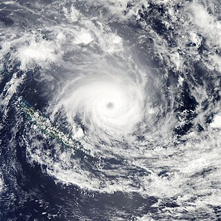
WSevere Tropical Cyclone Jasmine was a powerful and long-lived annular tropical cyclone that affected several countries, particularly Vanuatu and Tonga, over a 16-day span in February 2012. The system was the second cyclone and the only severe tropical cyclone of the relatively quiet 2011–12 South Pacific cyclone season. Cyclone Jasmine developed from an area of disturbed weather on 1 February in the Gulf of Carpentaria. Initially, the storm moved towards the east and across the Cape York Peninsula. As it moved across the South Pacific, earlier existing wind shear conditions lessened, and Jasmine began to strengthen at a faster rate. Steadily intensifying, Jasmine reached peak intensity on 8 February as a Category 4 equivalent on the Saffir–Simpson Hurricane Scale, while beginning to show annular characteristics.
 W
WTyphoon Jelawat, known in the Philippines as Typhoon Lawin, was the most intense tropical cyclone of the 2012 Pacific typhoon season in terms of ten-minute maximum sustained winds, tied with Typhoon Sanba. Following Bolaven and Sanba, Jelawat was the third typhoon directly hitting Okinawa Island in 2012. Jelawat, which means carp in Malaysian, is a type of freshwater fish.
 W
WTyphoon Kai-tak, known in the Philippines as Tropical Storm Helen, was a mild tropical cyclone that affected China, Vietnam and Laos. It was the seventh typhoon and the thirteenth named storm of the 2012 Pacific typhoon season. The storm killed 41 people and caused a sum of US$765 million in losses. Kai-tak can be tracked back to the broad area of disturbance embedded in a monsoonal trough that was first spotted, early on August 10. It was only at midnight, on August 16, when the JMA officially declared Kai-tak a typhoon. On the morning of August 17, the windspeed dropped to 60 knots and was no longer a typhoon. The typhoon caused heavy damage in China's two provinces killing four people and causing huge economic loss. Kai-Tak slammed the northern Philippines triggering flash floods and landslides and killing at least ten people, one week after deadly monsoon rains battered the country. In Vietnam, Kai-Tak has stormed across the country's north bringing high winds and floods to several areas including the capital Hanoi.
 W
WSevere Tropical Storm Khanun, known in the Philippines as Tropical Storm Enteng, was the first tropical cyclone to directly impact Korea in two years. It is the 8th named storm, the 3rd severe tropical storm, and overall, the 13th tropical cyclone to be monitored by the Japan Meteorological Agency (JMA) during 2012. Khanun was also the first tropical storm to make a landfall over Korea in 2012. Khanun means "jack fruit" in Thai.
 W
WHurricane Leslie was an Atlantic tropical cyclone that had minor effects in Bermuda and Atlantic Canada in September 2012. The twelfth tropical cyclone of the annual hurricane season, Leslie developed from a tropical wave located nearly 1,500 miles (2,400 km) east of the Leeward Islands on August 30. About twelve hours later, it strengthened into Tropical Storm Leslie. Tracking steadily west-northwestward, it slowly intensified due to only marginally favorable conditions. By September 2, the storm curved north-northwestward while located north of the Leeward Islands. Thereafter, a blocking pattern over Atlantic Canada caused Leslie to drift for four days. Late on September 5, Leslie was upgraded to a Category 1 hurricane. However, due to its slow movement, the storm causing upwelling, which decreased sea surface temperatures (SST's), weakening Leslie back to a tropical storm on September 7.
 W
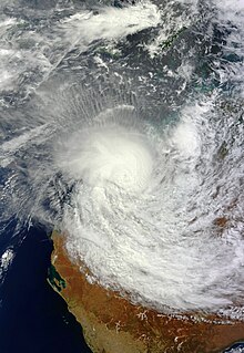
WSevere Tropical Cyclone Lua affected a sparsely populated region of Western Australia during mid-March 2012. Originating in a broad low pressure area that formed northwest of Australia by 8 March, the storm was plagued by inhibiting wind shear for the duration of its formative stages. However, it gradually organised, and received the name Lua on 13 March. The cyclone meandered for the first several days of its existence, caught between weak and competing steering currents. After the cyclone drifted northwestward, a building ridge of high pressure to the north drove Lua southeastward toward the Pilbara region. Ultimately intensifying into an upper-end Category 3 severe tropical cyclone with maximum sustained 10-minute winds of 155 km/h (100 mph), Lua made landfall near the remote community of Pardoo, about 150 km (95 mi) east of Port Hedland. It steadily weakened as it progressed south over interior Western Australia, diminishing below tropical cyclone status on 18 March.
 W
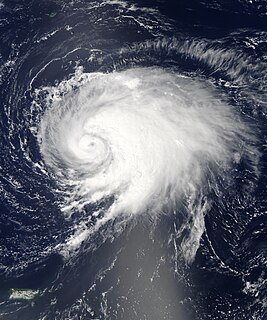
WHurricane Nadine was the fourth-longest-lived Atlantic hurricane on record. As the fourteenth tropical cyclone and named storm of the 2012 Atlantic hurricane season, Nadine developed from a tropical wave traveling west of Cape Verde on September 10. On the following day, it had strengthened into Tropical Storm Nadine. After initially tracking northwestward, Nadine turned northward, well away from any landmass. Early on September 15, Nadine reached hurricane status as it was curving eastward. Soon after, an increase in vertical wind shear weakened Nadine and by September 16 it was back to a tropical storm. On the following day, the storm began moving northeastward and threatened the Azores but late on September 19, Nadine veered east-southeastward before reaching the islands. Nonetheless, the storm produced tropical storm force winds on a few islands. On September 21, the storm curved south-southeastward while south of the Azores. Later that day, Nadine transitioned into a non-tropical low pressure area.
 W
WCyclonic Storm Nilam was the deadliest tropical cyclone to directly affect South India since Cyclone Jal in 2010. Originating from an area of low pressure over the Bay of Bengal on October 28, 2012, the system began as a weak depression 550 km (340 mi) northeast of Trincomalee, Sri Lanka. Over the following few days, the depression gradually intensified into a deep depression, and subsequently a cyclonic storm by October 30. It made landfall near Mahabalipuram on October 31 as a strong cyclonic storm with peak winds of 85 km/h (50 mph). In Chennai's Marina Beach, strong winds pushed piles of sand ashore and seawater reached nearly a 100 m (330 ft) inland. Schools and colleges in the city remained closed for more than three days.
 W
WTropical Storm Norman was the fourteenth tropical cyclone of the 2012 Pacific hurricane season that brought minor flooding to western Mexico and record rainfall to areas of Texas in September 2012. Originating from a disturbance near the southern tip of Baja California, it soon moves north and developed into a tropical cyclone on September 28. Upon developing into one, Norman attained its peak intensity with maximum sustained winds of 50 mph (85 km/h). Heading northward into the Gulf of California, the storm began to weaken later that day due to southwesterly wind shear and land interaction. Norman curved northwestward and weakened to a tropical depression early on September 29. Around that time, it briefly moved inland near Topolobampo, Sinaloa, before re-emerging into the Gulf of California. Later on September 29, Norman degenerated into a remnant low pressure area.
 W
WHurricane Paul was a strong tropical cyclone that threatened the Baja California peninsula during October 2012. The sixteenth tropical cyclone, tenth hurricane, and fifth major hurricane of the season, Paul originated from a trough of low pressure west of the coastline of Mexico on October 13. While turning towards the north, the system quickly organized, reaching hurricane status on the afternoon of October 15. By that afternoon, Paul had reached its peak intensity as a Category 3 hurricane on the Saffir-Simpson hurricane wind scale (SSHWS) with maximum sustained winds of 120 mph (195 km/h), but began to weaken rapidly thereafter due to land interaction and strong wind shear. Late on October 17, Paul degenerated into a remnant low. The remnants of Paul later moved ashore along the central Baja California Peninsula.
 W
WHurricane Rafael produced minor damage in the northeastern Caribbean Sea in mid-October 2012. The seventeenth named storm and ninth hurricane of the annual hurricane season, Rafael originated from a tropical wave roughly 230 mi (370 km) south-southeast of Saint Croix on October 12; because the system already contained tropical storm-force winds, it skipped tropical depression status. Though initially disorganized due to moderate wind shear, a subsequent decrease allowed for shower and thunderstorm activity to develop in earnest by October 14. While moving north-northwestward the following morning, Rafael intensified into a Category 1 hurricane. A cold front off the East Coast of the United States caused the system to turn northward and eventually northeastward by October 16, at which time Rafael attained its peak intensity with maximum sustained winds of 90 mph (150 km/h). As the cyclone entered a more stable atmosphere and tracked across increasingly cooler sea surface temperatures, it began extratropical transition, a process the system completed by the following afternoon.
 W
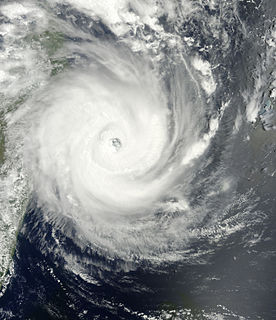
WTyphoon Sanba, known in the Philippines as Typhoon Karen, was the strongest tropical cyclone worldwide in 2012. The sixteenth named storm and tenth typhoon of the annual typhoon season, Sanba formed as a tropical depression east of The Philippines on September 10. The storm gradually intensified as it moved generally northward in an area favorable for tropical development. The system was soon upgraded to a tropical storm less than a day after formation and subsequently further to a typhoon on September 12. Later that day, Sanba entered a phase of explosive intensification, quickly strengthening and gaining annular characteristics. On September 13, the system attained its peak intensity with maximum sustained winds of 125 mph (205 km/h), and a barometric pressure of 900 mbar, becoming the strongest typhoon in the Western Pacific Ocean since Megi in 2010. Accelerating towards more northerly latitudes, a period of gradual weakening ensued afterwards as its eye expanded. It made landfall on South Korea late on September 17 as a typhoon before transitioning into an extratropical cyclone the following day. Sanba's remnants tracked into the Primorsky Krai region of eastern Russia before they were last noted on September 19.
 W
WHurricane Sandy was the deadliest and most destructive, as well as the strongest hurricane of the 2012 Atlantic hurricane season. The storm inflicted nearly $70 billion in damage and killed 233 people across eight countries from the Caribbean to Canada. The eighteenth named storm, tenth hurricane, and second major hurricane of the year, Sandy was a Category 3 storm at its peak intensity when it made landfall in Cuba. While it was a Category 2 hurricane off the coast of the Northeastern United States, the storm became the largest Atlantic hurricane on record.
 W
WTyphoon Saola, known in the Philippines as Typhoon Gener and in Taiwan as Typhoon Sura, was a strong tropical cyclone affecting the Philippines, Taiwan and China. It was the ninth named storm and the fourth typhoon of the 2012 Pacific typhoon season. Saola is the name of a rare mammal found in Vietnam.
 W
WTyphoon Son-Tinh, known in the Philippines as Tropical Storm Ofel, was a powerful, late-forming typhoon that devastated the Philippines with tropical storm strength, and battered Northern Vietnam with hurricane-force winds at landfall on October 28, 2012. Originating from a broad area of low pressure over Palau on October 20, the system strengthened into a tropical depression by October 21, and on October 22, it became the 23rd named storm of the season.
 W
WTyphoon Tembin, known in the Philippines as Typhoon Igme, was a strong tropical cyclone which unusually approached Taiwan twice. Tembin, which means Libra in Japanese, was the eighth typhoon and the fourteenth named storm of the 2012 Pacific typhoon season. After making landfall over the southern tip of Taiwan late on August 23, Tembin weakened but regained strength in the South China Sea, looping before making a second landfall on southern Taiwan as a tropical storm on August 27. However, the system did not restrengthen in the East China Sea, and made landfall over South Korea on August 30 before becoming extratropical.
 W
WTyphoon Vicente, known in the Philippines as Tropical Depression Ferdie, was the strongest tropical cyclone to strike the Chinese province of Guangdong since Hagupit in 2008, and was regarded as the strongest storm to affect Hong Kong and Macau in more than ten years. The eighth named storm and third typhoon in the 2012 Pacific typhoon season, Vicente began life as a tropical depression on July 18, 2012 north east of the Philippines. Vicente soon steadily moved into the South China Sea, and began to intensify above warm sea waters, and began explosive intensification early on July 23, and started to charge toward the Guangdong region prompting the Hong Kong Observatory (HKO) to issue the Hurricane Signal, No. 10, the first since York in 1999. The Macao Meteorological and Geophysical Bureau also hoisted the Signal No. 9 for the first time since York and after the transfer of sovereignty over Macau. Late on the same day, Vicente made landfall over Taishan in Guangdong, China.